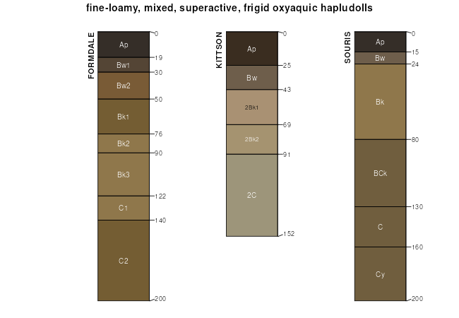
| Balaton-Souris-Svea loams, 0 to 4 percent slopes | F1152B | 118224 | 3247647 | 2ykxf | nd005 | | 1:12000 |
Balaton-Souris-Svea loams, 3 to 9 percent slopes | F1152C | 30640 | 3247648 | 2ykxg | nd005 | | 1:12000 |
Souris-Balaton-Svea loams, 0 to 4 percent slope | F1153B | 18785 | 3247649 | 2ykxh | nd005 | | 1:12000 |
Balaton-Souris loams, 0 to 4 percent slopes | F1169B | 1493 | 3247644 | 2ykx9 | nd005 | | 1:12000 |
Wyard-Souris-Balaton loams, 0 to 3 percent slopes | F1151A | 623 | 3247650 | 2ykxk | nd005 | | 1:12000 |
Hamlet-Souris-Tonka complex, 0 to 3 percent slopes | F158A | 154330 | 2989626 | 2vyjx | nd009 | 1981 | 1:20000 |
Hamlet-Souris loams, 1 to 3 percent slopes | F160A | 26577 | 2989624 | 2vyjq | nd009 | 1981 | 1:20000 |
Hamlet-Souris-Balaton loams, 1 to 5 percent slopes | F155B | 16441 | 2989619 | 2vyjt | nd009 | 1981 | 1:20000 |
Hamlet-Souris loams, 1 to 5 percent slopes | F160B | 1740 | 2989625 | 2vyjr | nd009 | 1981 | 1:20000 |
Hamlet-Souris-Tonka complex, 0 to 5 percent slopes | F158B | 669 | 2989623 | 2vyjy | nd009 | 1981 | 1:20000 |
Hamlet-Souris loams, 1 to 3 percent slopes | F160A | 7439 | 2989628 | 2vyjq | nd013 | 1991 | 1:24000 |
Hamlet-Souris-Tonka complex, 0 to 3 percent slopes | F158A | 2779 | 3011830 | 2vyjx | nd013 | 1991 | 1:24000 |
Hamlet-Souris loams, 1 to 5 percent slopes | F160B | 2275 | 2989629 | 2vyjr | nd013 | 1991 | 1:24000 |
Hamlet-Souris-Tonka complex, 0 to 5 percent slopes | F158B | 388 | 2989627 | 2vyjy | nd013 | 1991 | 1:24000 |
Balaton-Souris-Svea loams, 0 to 4 percent slopes | F1152B | 84170 | 3247668 | 2ykxf | nd019 | 1987 | 1:20000 |
Souris-Balaton-Svea loams, 0 to 4 percent slope | F1153B | 10499 | 3247670 | 2ykxh | nd019 | 1987 | 1:20000 |
Balaton-Souris-Svea loams, 3 to 9 percent slopes | F1152C | 1406 | 3247669 | 2ykxg | nd019 | 1987 | 1:20000 |
Balaton-Souris loams, 0 to 4 percent slopes | F1169B | 847 | 3247665 | 2ykx9 | nd019 | 1987 | 1:20000 |
Wyard-Souris-Balaton loams, 0 to 3 percent slopes | F1151A | 400 | 3247671 | 2ykxk | nd019 | 1987 | 1:20000 |
Hamlet-Souris loams, 1 to 3 percent slopes | F160A | 32356 | 3011832 | 2vyjq | nd049 | 1987 | 1:20000 |
Hamlet-Souris loams, 1 to 5 percent slopes | F160B | 19578 | 3011833 | 2vyjr | nd049 | 1987 | 1:20000 |
Hamlet-Souris-Tonka complex, 0 to 3 percent slopes | F158A | 3940 | 3011834 | 2vyjx | nd049 | 1987 | 1:20000 |
Hamlet-Souris-Tonka complex, 0 to 5 percent slopes | F158B | 1430 | 3011831 | 2vyjy | nd049 | 1987 | 1:20000 |
Hamlet-Souris-Balaton loams, 1 to 5 percent slopes | F155B | 58 | 2989621 | 2vyjt | nd049 | 1987 | 1:20000 |
Balaton-Souris-Svea loams, 0 to 4 percent slopes | F1152B | 24078 | 3247689 | 2ykxf | nd063 | | 1:12000 |
Souris-Balaton-Svea loams, 0 to 4 percent slope | F1153B | 4281 | 3247691 | 2ykxh | nd063 | | 1:12000 |
Balaton-Souris-Svea loams, 3 to 9 percent slopes | F1152C | 2020 | 3247690 | 2ykxg | nd063 | | 1:12000 |
Balaton-Souris loams, 0 to 4 percent slopes | F1169B | 412 | 3247686 | 2ykx9 | nd063 | | 1:12000 |
Wyard-Souris-Balaton loams, 0 to 3 percent slopes | F1151A | 126 | 3247692 | 2ykxk | nd063 | | 1:12000 |
Balaton-Souris-Svea loams, 0 to 4 percent slopes | F1152B | 16236 | 3247710 | 2ykxf | nd069 | 1975 | 1:20000 |
Souris-Balaton-Svea loams, 0 to 4 percent slope | F1153B | 7664 | 3247712 | 2ykxh | nd069 | 1975 | 1:20000 |
Balaton-Souris-Svea loams, 3 to 9 percent slopes | F1152C | 1248 | 3247711 | 2ykxg | nd069 | 1975 | 1:20000 |
Balaton-Souris loams, 0 to 4 percent slopes | F1169B | 445 | 3247707 | 2ykx9 | nd069 | 1975 | 1:20000 |
Wyard-Souris-Balaton loams, 0 to 3 percent slopes | F1151A | 117 | 3247713 | 2ykxk | nd069 | 1975 | 1:20000 |
Balaton-Souris-Svea loams, 0 to 4 percent slopes | F1152B | 152167 | 3247731 | 2ykxf | nd071 | 1984 | 1:12000 |
Souris-Balaton-Svea loams, 0 to 4 percent slope | F1153B | 28095 | 3247733 | 2ykxh | nd071 | 1984 | 1:12000 |
Balaton-Souris-Svea loams, 3 to 9 percent slopes | F1152C | 7606 | 3247732 | 2ykxg | nd071 | 1984 | 1:12000 |
Wyard-Souris-Balaton loams, 0 to 3 percent slopes | F1151A | 2929 | 3247734 | 2ykxk | nd071 | 1984 | 1:12000 |
Balaton-Souris loams, 0 to 4 percent slopes | F1169B | 1738 | 3247728 | 2ykx9 | nd071 | 1984 | 1:12000 |
Hamlet-Souris-Tonka complex, 0 to 3 percent slopes | F158A | 233229 | 3011838 | 2vyjx | nd075 | 1972 | 1:20000 |
Hamlet-Souris loams, 1 to 3 percent slopes | F160A | 95425 | 3011836 | 2vyjq | nd075 | 1972 | 1:20000 |
Hamlet-Souris loams, 1 to 5 percent slopes | F160B | 26151 | 3011837 | 2vyjr | nd075 | 1972 | 1:20000 |
Hamlet-Souris-Tonka complex, 0 to 5 percent slopes | F158B | 21843 | 3011835 | 2vyjy | nd075 | 1972 | 1:20000 |
Balaton-Souris-Svea loams, 0 to 4 percent slopes | F1152B | 75877 | 3247752 | 2ykxf | nd079 | 1990 | 1:24000 |
Souris-Balaton-Svea loams, 0 to 4 percent slope | F1153B | 11782 | 3247754 | 2ykxh | nd079 | 1990 | 1:24000 |
Balaton-Souris-Svea loams, 3 to 9 percent slopes | F1152C | 1760 | 3247753 | 2ykxg | nd079 | 1990 | 1:24000 |
Balaton-Souris loams, 0 to 4 percent slopes | F1169B | 700 | 3247749 | 2ykx9 | nd079 | 1990 | 1:24000 |
Wyard-Souris-Balaton loams, 0 to 3 percent slopes | F1151A | 346 | 3247755 | 2ykxk | nd079 | 1990 | 1:24000 |
Balaton-Souris-Svea loams, 0 to 4 percent slopes | F1152B | 158357 | 3247773 | 2ykxf | nd095 | 1992 | 1:24000 |
Souris-Balaton-Svea loams, 0 to 4 percent slope | F1153B | 35100 | 3247775 | 2ykxh | nd095 | 1992 | 1:24000 |
Balaton-Souris-Svea loams, 3 to 9 percent slopes | F1152C | 4134 | 3247774 | 2ykxg | nd095 | 1992 | 1:24000 |
Wyard-Souris-Balaton loams, 0 to 3 percent slopes | F1151A | 2069 | 3247776 | 2ykxk | nd095 | 1992 | 1:24000 |
Balaton-Souris loams, 0 to 4 percent slopes | F1169B | 1871 | 3247770 | 2ykx9 | nd095 | 1992 | 1:24000 |
Hamlet-Souris-Tonka complex, 0 to 3 percent slopes | F158A | 121211 | 3011842 | 2vyjx | nd101 | 1967 | 1:20000 |
Hamlet-Souris loams, 1 to 3 percent slopes | F160A | 60957 | 3011840 | 2vyjq | nd101 | 1967 | 1:20000 |
Hamlet-Souris loams, 1 to 5 percent slopes | F160B | 30790 | 3011841 | 2vyjr | nd101 | 1967 | 1:20000 |
Hamlet-Souris-Tonka complex, 0 to 5 percent slopes | F158B | 7858 | 3011839 | 2vyjy | nd101 | 1967 | 1:20000 |