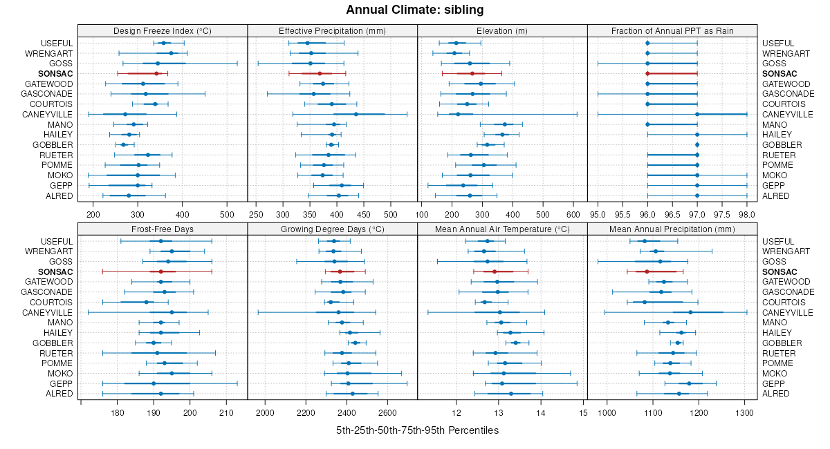
| Sonsac flaggy silt loam, 18 to 35 percent slopes | 658F | 4582 | 184110 | 65l1 | il133 | 1998 | 1:12000 |
Hailey-Sonsac complex, 35 to 70 percent slopes, very rocky | 73353 | 1229 | 2536096 | 2qpxy | mo009 | 1990 | 1:24000 |
Sonsac-Gobbler complex, 20 to 35 percent slopes, very stony | 70036 | 319 | 2534036 | 2qpc1 | mo009 | 1990 | 1:24000 |
Gobbler-Sonsac complex, 8 to 15 percent slopes, stony | 73128 | 102 | 2534837 | 2qpj0 | mo009 | 1990 | 1:24000 |
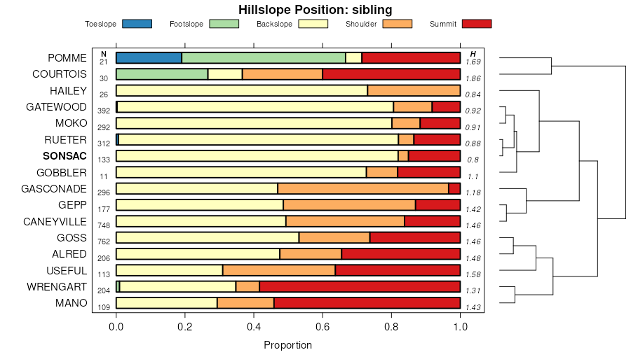
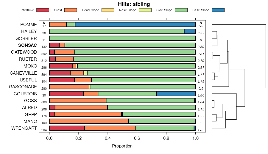
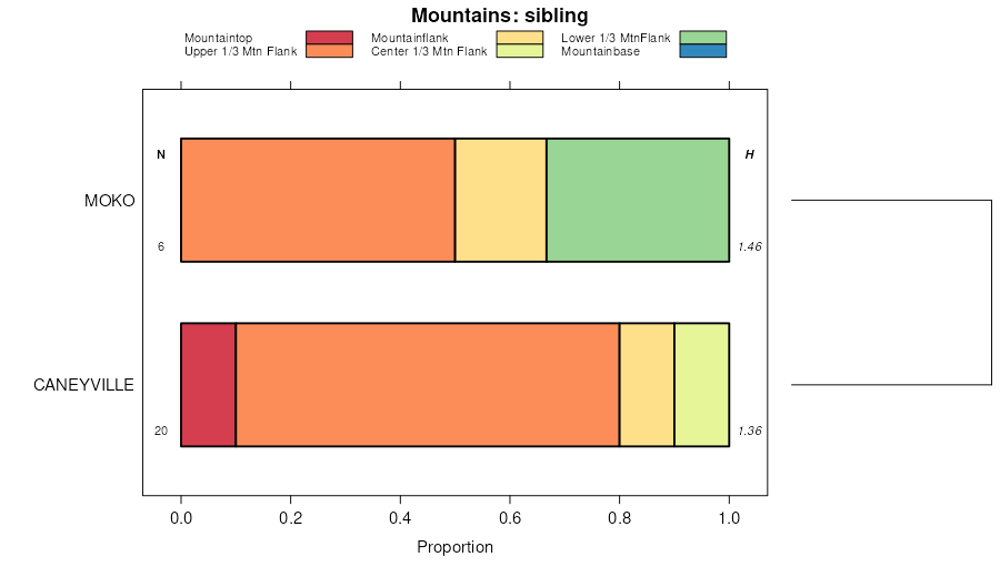
Sonsac-Moko-Rock outcrop complex, 3 to 15 percent slopes | 70043 | 13448 | 2534054 | 2qpc4 | mo039 | 2001 | 1:24000 |
Sonsac-Moko complex, 15 to 35 percent slopes, rocky | 70044 | 11038 | 2534059 | 2qpc5 | mo039 | 2001 | 1:24000 |
Alred-Sonsac complex, 15 to 35 percent slopes, very rocky, very stony | 73282 | 34367 | 2502288 | 2vxrl | mo055 | 2003 | 1:24000 |
Sonsac-Moko-Rock outcrop complex, 15 to 50 percent slopes, extremely stony | 73279 | 6127 | 2502278 | 2vxrj | mo055 | 2003 | 1:24000 |
Sonsac gravelly silt loam, 3 to 15 percent slopes, very stony | 73200 | 1932 | 2501749 | 2vxqw | mo055 | 2003 | 1:24000 |
Useful-Sonsac complex, 15 to 35 percent slopes, eroded | 73287 | 682 | 2502306 | 2q1qx | mo055 | 2003 | 1:24000 |
Sonsac-Moko-Rock outcrop complex, 3 to 15 percent slopes | 70043 | 15969 | 2534053 | 2qpc4 | mo057 | 1996 | 1:24000 |
Sonsac-Moko complex, 15 to 35 percent slopes, rocky | 70044 | 9035 | 2534058 | 2qpc5 | mo057 | 1996 | 1:24000 |
Alred-Sonsac complex, 15 to 35 percent slopes, very rocky, very stony | 73282 | 266 | 2502289 | 2vxrl | mo065 | 1971 | 1:24000 |
Sonsac-Moko-Rock outcrop complex, 15 to 50 percent slopes, extremely stony | 73279 | 44 | 2502279 | 2vxrj | mo065 | 1971 | 1:24000 |
Alred-Sonsac complex, 15 to 35 percent slopes, very rocky, very stony | 73282 | 1118 | 2502290 | 2vxrl | mo071 | 1986 | 1:24000 |
Rueter-Sonsac complex, 15 to 55 percent slopes, extremely stony | 73203 | 267 | 2501763 | 2vxqz | mo071 | 1986 | 1:24000 |
Sonsac gravelly silt loam, 15 to 40 percent slopes, very stony | 73201 | 216 | 2501755 | 2vxqx | mo071 | 1986 | 1:24000 |
Sonsac-Moko-Rock outcrop complex, 15 to 50 percent slopes, extremely stony | 73279 | 171 | 2502280 | 2vxrj | mo071 | 1986 | 1:24000 |
Sonsac gravelly silt loam, 3 to 15 percent slopes, very stony | 73200 | 21 | 2501750 | 2vxqw | mo071 | 1986 | 1:24000 |
Useful-Sonsac complex, 15 to 35 percent slopes, eroded | 73287 | 4 | 2502307 | 2q1qx | mo071 | 1986 | 1:24000 |
Sonsac-Moko complex, 15 to 35 percent slopes, rocky | 70044 | 205 | 2534060 | 2qpc5 | mo077 | 1979 | 1:24000 |
Sonsac-Moko-Rock outcrop complex, 3 to 15 percent slopes | 70043 | 103 | 2534056 | 2qpc4 | mo077 | 1979 | 1:24000 |
Sonsac-Moko-Rock outcrop complex, 15 to 50 percent slopes, extremely stony | 73279 | 9 | 2502281 | 2vxrj | mo093 | 1988 | 1:24000 |
Sonsac gravelly silt loam, 15 to 40 percent slopes, very stony | 73201 | 3 | 2501756 | 2vxqx | mo093 | 1988 | 1:24000 |
Sonsac gravelly silt loam, 15 to 40 percent slopes, very stony | 73201 | 78248 | 2501757 | 2vxqx | mo099 | 2000 | 1:24000 |
Rueter-Sonsac complex, 15 to 55 percent slopes, extremely stony | 73203 | 8112 | 2501764 | 2vxqz | mo099 | 2000 | 1:24000 |
Sonsac gravelly silt loam, 3 to 15 percent slopes, very stony | 73200 | 2902 | 2501751 | 2vxqw | mo099 | 2000 | 1:24000 |
Useful-Sonsac complex, 15 to 50 percent slopes, very stony | 73217 | 2553 | 574236 | m8jr | mo099 | 2000 | 1:24000 |
Sonsac-Moko-Rock outcrop complex, 3 to 15 percent slopes | 70043 | 76 | 2534057 | 2qpc4 | mo109 | 1979 | 1:24000 |
Sonsac-Moko complex, 15 to 35 percent slopes, rocky | 70044 | 21 | 2534061 | 2qpc5 | mo109 | 1979 | 1:24000 |
Hailey-Sonsac complex, 35 to 70 percent slopes, very rocky | 73353 | 37280 | 2536097 | 2qpxy | mo119 | 2004 | 1:24000 |
Sonsac-Rueter complex, 15 to 35 percent slopes, rocky | 73351 | 1191 | 808574 | w4d1 | mo119 | 2004 | 1:24000 |
Hailey-Sonsac complex, 35 to 70 percent slopes, very rocky | 73353 | 28 | 2536095 | 2qpxy | mo145 | 1984 | 1:24000 |
Sonsac-Moko-Rock outcrop complex, 3 to 15 percent slopes | 70043 | 125 | 2534055 | 2qpc4 | mo185 | 1984 | 1:24000 |
Rueter-Sonsac complex, 15 to 55 percent slopes, extremely stony | 73203 | 1263 | 2501766 | 2vxqz | mo186 | 1982 | 1:24000 |
Rueter-Sonsac complex, 15 to 55 percent slopes, extremely stony | 73203 | 839 | 2501765 | 2vxqz | mo187 | 1979 | 1:24000 |
Sonsac gravelly silt loam, 15 to 40 percent slopes, very stony | 73201 | 136 | 2501758 | 2vxqx | mo187 | 1979 | 1:24000 |
Sonsac-Moko-Rock outcrop complex, 15 to 50 percent slopes, extremely stony | 73279 | 19 | 2502282 | 2vxrj | mo187 | 1979 | 1:24000 |
Sonsac gravelly silt loam, 3 to 15 percent slopes, very stony | 73200 | 16 | 2501752 | 2vxqw | mo187 | 1979 | 1:24000 |
Alred-Sonsac complex, 15 to 35 percent slopes, very rocky, very stony | 73282 | 12 | 2502291 | 2vxrl | mo187 | 1979 | 1:24000 |
Sonsac gravelly silt loam, 15 to 40 percent slopes, very stony | 73201 | 19 | 2501754 | 2vxqx | mo189 | 1979 | 1:24000 |
Sonsac-Gobbler complex, 20 to 35 percent slopes, very stony | 70036 | 19641 | 2534037 | 2qpc1 | mo209 | 1998 | 1:24000 |
Sonsac-Gobbler complex, 15 to 20 percent slopes | 70035 | 6753 | 889813 | yvxn | mo209 | 1998 | 1:24000 |
Gobbler-Sonsac complex, 8 to 15 percent slopes, stony | 73128 | 4950 | 2534836 | 2qpj0 | mo209 | 1998 | 1:24000 |
Sonsac-Rueter complex, 35 to 70 percent slopes, very rocky | 70037 | 3319 | 889818 | yvxt | mo209 | 1998 | 1:24000 |
Gobbler-Sonsac complex, 3 to 8 percent slopes | 73127 | 2305 | 2534835 | 2qphz | mo209 | 1998 | 1:24000 |
Sonsac-Gobbler complex, 20 to 35 percent slopes, very stony | 70036 | 578 | 2534035 | 2qpc1 | mo213 | 1990 | 1:24000 |
Gobbler-Sonsac complex, 3 to 8 percent slopes | 73127 | 128 | 2534834 | 2qphz | mo213 | 1990 | 1:24000 |
Alred-Sonsac complex, 15 to 35 percent slopes, very rocky, very stony | 73282 | 91200 | 2502292 | 2vxrl | mo221 | 2003 | 1:24000 |
Sonsac-Moko-Rock outcrop complex, 15 to 50 percent slopes, extremely stony | 73279 | 16523 | 2502283 | 2vxrj | mo221 | 2003 | 1:24000 |
Sonsac gravelly silt loam, 15 to 40 percent slopes, very stony | 73201 | 10557 | 2501759 | 2vxqx | mo221 | 2003 | 1:24000 |
Sonsac gravelly silt loam, 3 to 15 percent slopes, very stony | 73200 | 8819 | 2501753 | 2vxqw | mo221 | 2003 | 1:24000 |
Useful-Sonsac complex, 15 to 35 percent slopes, eroded | 73287 | 1352 | 2502308 | 2q1qx | mo221 | 2003 | 1:24000 |