| Sonoma-Poole families complex, 0 to 2 percent slopes. | 377 | 3934 | 471490 | htmc | ca732 | 1998 | 1:24000 |
Sonoma-Poole families complex, 0 to 2 percent slopes. | 377iw | 21 | 488498 | htmc | ca802 | 1996 | 1:24000 |
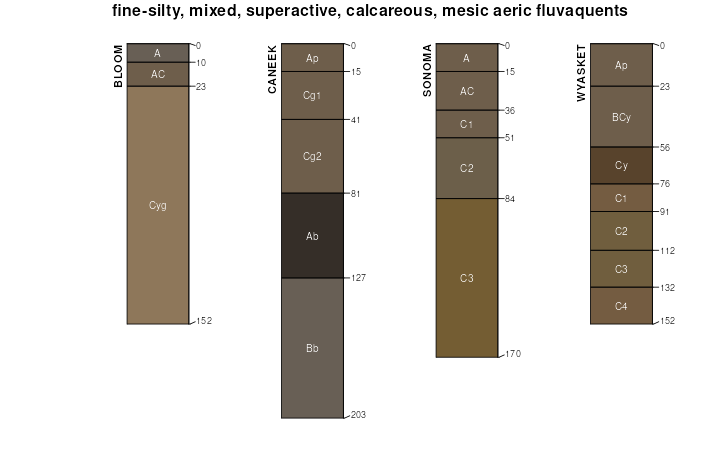
Sonoma silt loam, drained | 161 | 2750 | 477072 | j0ff | nv763 | 1986 | 1:24000 |
Sonoma-Sonoma, occasionally flooded association | 183 | 3925 | 474923 | hy63 | nv765 | 1986 | 1:24000 |
Sonoma-Deleplain-Ocala association | 187 | 3010 | 474926 | hy66 | nv765 | 1986 | 1:24000 |
Sonoma-Devilsgait-Sonoma, strongly saline-Sodic association | 180 | 2680 | 474921 | hy61 | nv765 | 1986 | 1:24000 |
Sonoma-Devilsgait-Sonoma, occasionally flooded association | 182 | 2520 | 474922 | hy62 | nv765 | 1986 | 1:24000 |
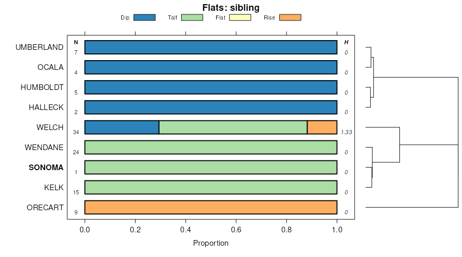
Kelk-Sonoma association | 580 | 2005 | 475058 | hybg | nv765 | 1986 | 1:24000 |
Sonoma-Ocala variant association | 185 | 1245 | 474924 | hy64 | nv765 | 1986 | 1:24000 |
Sonoma, frequently flooded-Devilsgait-Sonoma association | 164 | 820 | 2633855 | 2rgmx | nv765 | 1986 | 1:24000 |
Sonoma-Devilsgait association | 0310 | 722 | 2633874 | 2rgnh | nv765 | 1986 | 1:24000 |
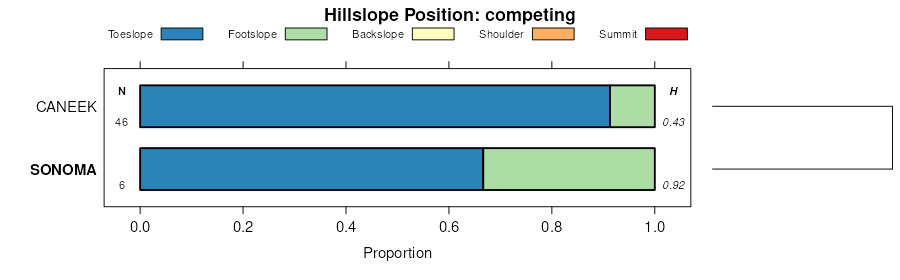
Kolda-Duffer-Sonoma association | 1620 | 1650 | 478670 | j22z | nv766 | 1994 | 1:24000 |
Sonoma-Kelk association | 311 | 554 | 478294 | j1pv | nv766 | 1994 | 1:24000 |
Sonoma-Devilsgait association | 310 | 344 | 478293 | j1pt | nv766 | 1994 | 1:24000 |
Sonoma, frequently flooded-Devilsgait-Sonoma association | 163 | 8593 | 478760 | j25w | nv767 | 1986 | 1:24000 |
Kelk-Sonoma association | 149 | 3818 | 478753 | j25n | nv767 | 1986 | 1:24000 |
Sonoma-Sonoma, rarely flooded association | 161 | 3282 | 478758 | j25t | nv767 | 1986 | 1:24000 |
Devilsgait-Sonoma association | 443 | 3019 | 478911 | j2br | nv767 | 1986 | 1:24000 |
Ocala-Sonoma association | 259 | 2749 | 478859 | j292 | nv767 | 1986 | 1:24000 |
Sonoma-Hussa association | 162 | 2339 | 478759 | j25v | nv767 | 1986 | 1:24000 |
Sonoma variant-Halleck association | 294 | 2030 | 478868 | j29c | nv767 | 1986 | 1:24000 |
Sonoma-Kelk association | 167 | 1200 | 478766 | j262 | nv767 | 1986 | 1:24000 |
Sonoma-Devilsgait association | 166 | 1177 | 478762 | j25y | nv767 | 1986 | 1:24000 |
Wendane-Sonoma-Valmy association | 1146 | 8809 | 479041 | j2gy | nv768 | 1985 | 1:63360 |
Ocala-Sonoma-Paranat association | 683 | 8647 | 479296 | j2r5 | nv768 | 1985 | 1:63360 |
Sonoma-Paranat association | 998 | 8364 | 479315 | j2rs | nv768 | 1985 | 1:63360 |
Sonoma-Wendane association | 990 | 3601 | 479314 | j2rr | nv768 | 1985 | 1:63360 |
Sonoma-Wendane-Paranat association | 999 | 2196 | 479316 | j2rt | nv768 | 1985 | 1:63360 |
Yobe-Sonoma association | 1411 | 6543 | 475213 | hyhg | nv769 | 1986 | 1:24000 |
Sonoma silt loam, occasionally flooded, strongly saline-sodic | 561 | 3988 | 475279 | hykl | nv769 | 1986 | 1:24000 |
Sonoma silt loam | 4200 | 2021 | 476973 | j0b7 | nv774 | 1985 | 1:24000 |
Sonoma silty clay loam, frequently flooded | 567 | 6786 | 2633951 | 2rhg7 | nv775 | 1985 | 1:24000 |
Batan-Wendane-Sonoma association | 166 | 6460 | 479488 | j2yc | nv775 | 1985 | 1:24000 |
Wendane-Sonoma-Valmy association | 1146 | 1955 | 479419 | j2w4 | nv775 | 1985 | 1:24000 |
Sonoma silty clay loam, strongly saline, occasionally flooded | 995 | 1875 | 479754 | j36y | nv775 | 1985 | 1:24000 |
Sonoma silty clay loam, drained, strongly saline, occasionally flooded | 994 | 1325 | 479753 | j36x | nv775 | 1985 | 1:24000 |
Argenta-Sonoma complex | 152 | 1220 | 479477 | j2y0 | nv775 | 1985 | 1:24000 |
Prida-Sonoma silty clay loams | 774 | 955 | 479717 | j35r | nv775 | 1985 | 1:24000 |
Sonoma silt loam, strongly saline, rarely flooded | 992 | 955 | 479751 | j36v | nv775 | 1985 | 1:24000 |
Sonoma silty clay loam, strongly saline | 563 | 421 | 2633950 | 2rhg6 | nv775 | 1985 | 1:24000 |
Sonoma silt loam, drained | 990 | 335 | 479749 | j36s | nv775 | 1985 | 1:24000 |
Sonoma silty clay loam, strongly saline, frequently flooded | 997 | 305 | 479756 | j370 | nv775 | 1985 | 1:24000 |
Sonoma, strongly saline-Sonoma complex | 996 | 305 | 479755 | j36z | nv775 | 1985 | 1:24000 |
Sonoma silt loam, drained, slightly saline | 991 | 280 | 479750 | j36t | nv775 | 1985 | 1:24000 |
Sonoma variant silt loam | 200 | 120 | 479512 | j2z4 | nv775 | 1985 | 1:24000 |
Sonoma silty clay loam, strongly saline, frequently flooded | 997 | 86 | 2634062 | 2rn30 | nv776 | 1983 | 1:63360 |
Sonoma variant silt loam* | 200 | 68 | 479793 | j386 | nv776 | 1983 | 1:63360 |
Sonoma silt loam, strongly saline 1/ | 561 | 13408 | 475796 | hz38 | nv777 | 1993 | 1:24000 |
Sonoma-Paranat complex 1/ | 566 | 7364 | 475800 | hz3d | nv777 | 1993 | 1:24000 |
Sonoma silty clay loam, occasionally flooded 1/ | 562 | 6978 | 475797 | hz39 | nv777 | 1993 | 1:24000 |
Wendane-Sonoma complex 1/ | 1104 | 5507 | 475403 | hypl | nv777 | 1993 | 1:24000 |
Sonoma silty clay loam, strongly saline 1/ | 563 | 1305 | 475798 | hz3b | nv777 | 1993 | 1:24000 |
Sonoma silt loam, drained 1/ | 564 | 1152 | 475799 | hz3c | nv777 | 1993 | 1:24000 |
Sonoma silty clay loam, frequently flooded 1/ | 567 | 586 | 475801 | hz3f | nv777 | 1993 | 1:24000 |
Sonoma silt loam, 0 to 2 percent slopes | 414 | 427 | 3270871 | 2v4zr | nv777 | 1993 | 1:24000 |
Sonoma-Kelk association | 1020 | 4442 | 480137 | j3m9 | nv780 | 1990 | 1:24000 |
Sonoma silt loam, 0 to 2 percent slopes | 414 | 4328 | 2844654 | 2v4zr | or644 | 2021 | 1:24000 |
Wabuska-Sonoma complex, 0 to 2 percent slopes | 409 | 3914 | 2844632 | 2v4z0 | or644 | 2021 | 1:24000 |
Sonoma-Alvodest complex, 0 to 3 percent slopes | 411 | 2289 | 2844634 | 2v4z2 | or644 | 2021 | 1:24000 |