| Theon-Singatse association | 1051 | 26 | 2439163 | 2tfnh | nv602 | 1985 | 1:24000 |
Pirouette-Singatse-Hawsley association | 7201 | 12090 | 2427780 | 2mh9h | nv603 | 1971 | 1:24000 |
Theon-Singatse-Weena association | 7036 | 3701 | 2427762 | 2mh8x | nv603 | 1971 | 1:24000 |
Singatse-Theon association | 633 | 16921 | 474019 | hx7y | nv625 | 1981 | 1:24000 |
Pirouette-Singatse-Hawsley association | 7201 | 5631 | 2425579 | 2mf0h | nv625 | 1981 | 1:24000 |
Theon-Singatse-Hawsley association | 7202 | 5130 | 2425580 | 2tfnl | nv625 | 1981 | 1:24000 |
Theon-Singatse-Rock outcrop association | 7005 | 2600 | 2425530 | 2tfn8 | nv625 | 1981 | 1:24000 |
Theon-Singatse-Weena association | 7036 | 1899 | 2452818 | 2nbc5 | nv625 | 1981 | 1:24000 |
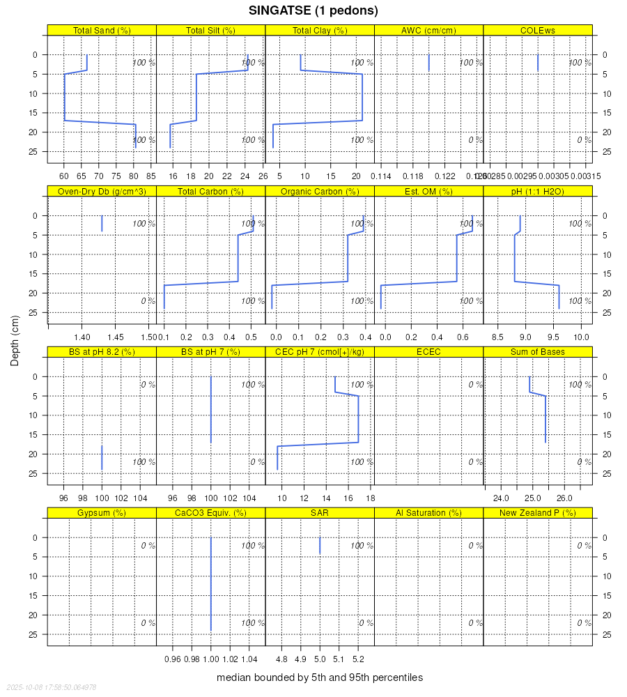
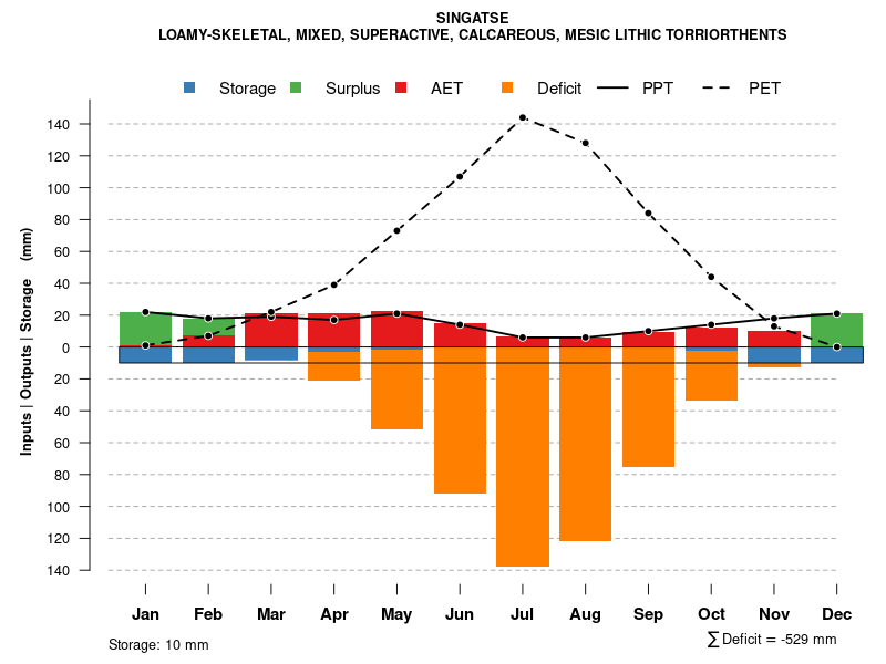
Singatse very gravelly sandy loam, 8 to 15 percent slopes | 631 | 1809 | 474017 | hx7w | nv625 | 1981 | 1:24000 |
Singatse-Rock outcrop association | 632 | 1747 | 474018 | 2tfn9 | nv625 | 1981 | 1:24000 |
Singatse-Weena-Rock outcrop association | 7009 | 42 | 2425551 | 2mdzl | nv625 | 1981 | 1:24000 |
Singatse-Fireball-Rednik association | 1370 | 8627 | 474189 | hxff | nv628 | 1980 | 1:24000 |
Singatse-Mizel-Stingdorn association | 1373 | 6427 | 474192 | hxfj | nv628 | 1980 | 1:24000 |
Singatse-Isolde association | 1372 | 5825 | 474191 | hxfh | nv628 | 1980 | 1:24000 |
Singatse-Flex-Acrelane association | 1371 | 5596 | 474190 | hxfg | nv628 | 1980 | 1:24000 |
Singatse-Fireball-Osobb associaton | 1374 | 3854 | 474193 | hxfk | nv628 | 1980 | 1:24000 |
Stingdorn-Singatse-Rock outcrop association | 1380 | 3769 | 474194 | hxfl | nv628 | 1980 | 1:24000 |
Theon-Singatse association | 1606 | 1825 | 474449 | 2tfnh | nv628 | 1980 | 1:24000 |
Pirouette-Singatse-Hawsley association | 7201 | 723 | 2452481 | 2nb09 | nv628 | 1980 | 1:24000 |
Singatse-Tuffman-Rock outcrop association | 1378 | 423 | 3014730 | 2xdmx | nv628 | 1980 | 1:24000 |
Singatse-Rocconda-Badland association | 806 | 29257 | 474804 | hy28 | nv760 | 1994 | 1:24000 |
Singatse-Jaybee association | 805 | 22771 | 474803 | hy27 | nv760 | 1994 | 1:24000 |
Singatse-Rock outcrop association | 804 | 17613 | 474802 | 2tfn9 | nv760 | 1994 | 1:24000 |
Theon-Singatse association | 1051 | 46652 | 476217 | 2tfnh | nv761 | 1988 | 1:24000 |
Theon-Singatse association, cobbly | 1050 | 1939 | 476216 | hzjt | nv761 | 1988 | 1:24000 |
Theon-Singatse association | 191 | 31028 | 475240 | 2tfnh | nv769 | 1986 | 1:24000 |
Theon-Singatse-Rock outcrop association | 190 | 25355 | 475239 | 2tfn8 | nv769 | 1986 | 1:24000 |
Singatse-Rock outcrop association, very steep | 3030 | 4667 | 475257 | 2w4dj | nv769 | 1986 | 1:24000 |
Singatse-Jobpeak-Rock outcrop association | 3031 | 1170 | 475258 | hyjx | nv769 | 1986 | 1:24000 |
Theon-Singatse-Rock outcrop association | 191 | 82575 | 476476 | 2tfn8 | nv770 | 1995 | 1:24000 |
Singatse-Rock outcrop association, very steep | 160 | 38549 | 476455 | 2w4dj | nv770 | 1995 | 1:24000 |
Singatse-Theon-Rezave association | 162 | 27528 | 476457 | hzsl | nv770 | 1995 | 1:24000 |
Old Camp-Singatse-Rock outcrop association | 302 | 22547 | 476523 | hzvq | nv770 | 1995 | 1:24000 |
Roic-Singatse-Celeton association | 1144 | 11906 | 476412 | hzr4 | nv770 | 1995 | 1:24000 |
Coppereid-Singatse-Findout association | 880 | 9589 | 476682 | j00v | nv770 | 1995 | 1:24000 |
Hooplite-Old Camp-Singatse association | 731 | 9265 | 476655 | hzzz | nv770 | 1995 | 1:24000 |
Osobb-Singatse-Pirouette association | 691 | 5169 | 476649 | hzzs | nv770 | 1995 | 1:24000 |
Rezave-Singatse-Rock outcrop association | 250 | 4576 | 476510 | hzv9 | nv770 | 1995 | 1:24000 |
Pirouette-Singatse-Hawsley association | 7201 | 3855 | 2425540 | 2mdz7 | nv770 | 1995 | 1:24000 |
Theon-Hooplite-Singatse association | 194 | 3717 | 476479 | hzt9 | nv770 | 1995 | 1:24000 |
Theon-Roic-Singatse association | 1104 | 3591 | 476404 | hzqw | nv770 | 1995 | 1:24000 |
Findout-Uripnes-Singatse association | 620 | 3571 | 476631 | hzz6 | nv770 | 1995 | 1:24000 |
Theon-Olac-Singatse association | 199 | 3516 | 476484 | hztg | nv770 | 1995 | 1:24000 |
Sojur-Singatse association | 1160 | 3315 | 476415 | hzr7 | nv770 | 1995 | 1:24000 |
Singatse-Loomer association | 164 | 2462 | 476459 | hzsn | nv770 | 1995 | 1:24000 |
Singatse-Weena-Rock outcrop association | 7009 | 2446 | 2425536 | 2mdz3 | nv770 | 1995 | 1:24000 |
Singatse-Uripnes-Rock outcrop association | 161 | 1154 | 476456 | hzsk | nv770 | 1995 | 1:24000 |
Theon-Trocken-Singatse association | 1373 | 7195 | 477355 | j0qk | nv771 | 1990 | 1:24000 |
Jaybee-Theon-Singatse association | 1320 | 6762 | 477342 | j0q4 | nv771 | 1990 | 1:24000 |
Slocave-Singatse-Jaybee association | 892 | 4517 | 477578 | j0yr | nv771 | 1990 | 1:24000 |
Hooplite-Singatse association | 1310 | 3966 | 477340 | j0q2 | nv771 | 1990 | 1:24000 |
Singatse-Jaybee association | 1230 | 1394 | 477322 | j0ph | nv771 | 1990 | 1:24000 |
Theon-Singatse-Rock outcrop association | 7005 | 32561 | 2425531 | 2tfn8 | nv774 | 1985 | 1:24000 |
Theon-Singatse-Hawsley association | 7202 | 8835 | 2425607 | 2tfnl | nv774 | 1985 | 1:24000 |
Singatse-Theon- Rock outcrop association | 1090 | 5331 | 476709 | 2xdmq | nv774 | 1985 | 1:24000 |
Singatse-Hawsley association | 1094 | 3547 | 476711 | 2xdmr | nv774 | 1985 | 1:24000 |
Singatse-Gynelle-Bluewing association | 1091 | 2706 | 476710 | j01r | nv774 | 1985 | 1:24000 |
Hawsley-Sodaspring-Singatse association | 7091 | 1983 | 2425597 | 2mf12 | nv774 | 1985 | 1:24000 |
Pirouette-Singatse-Hawsley association | 7201 | 70 | 2425729 | 2mf5b | nv774 | 1985 | 1:24000 |
Singatse-Theon- Rock outcrop association | 1071 | 1185 | 480675 | 2xdmq | nv781 | 1994 | 1:24000 |
Singatse-Hawsley association | 1076 | 1112 | 480676 | 2xdmr | nv781 | 1994 | 1:24000 |

