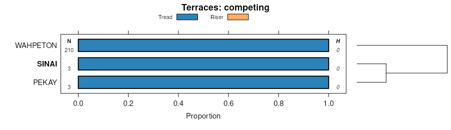
| Sinai silty clay, levees, 0 to 6 percent slopes | I475B | 314 | 2798105 | 2pg9f | mn027 | 1980 | 1:20000 |
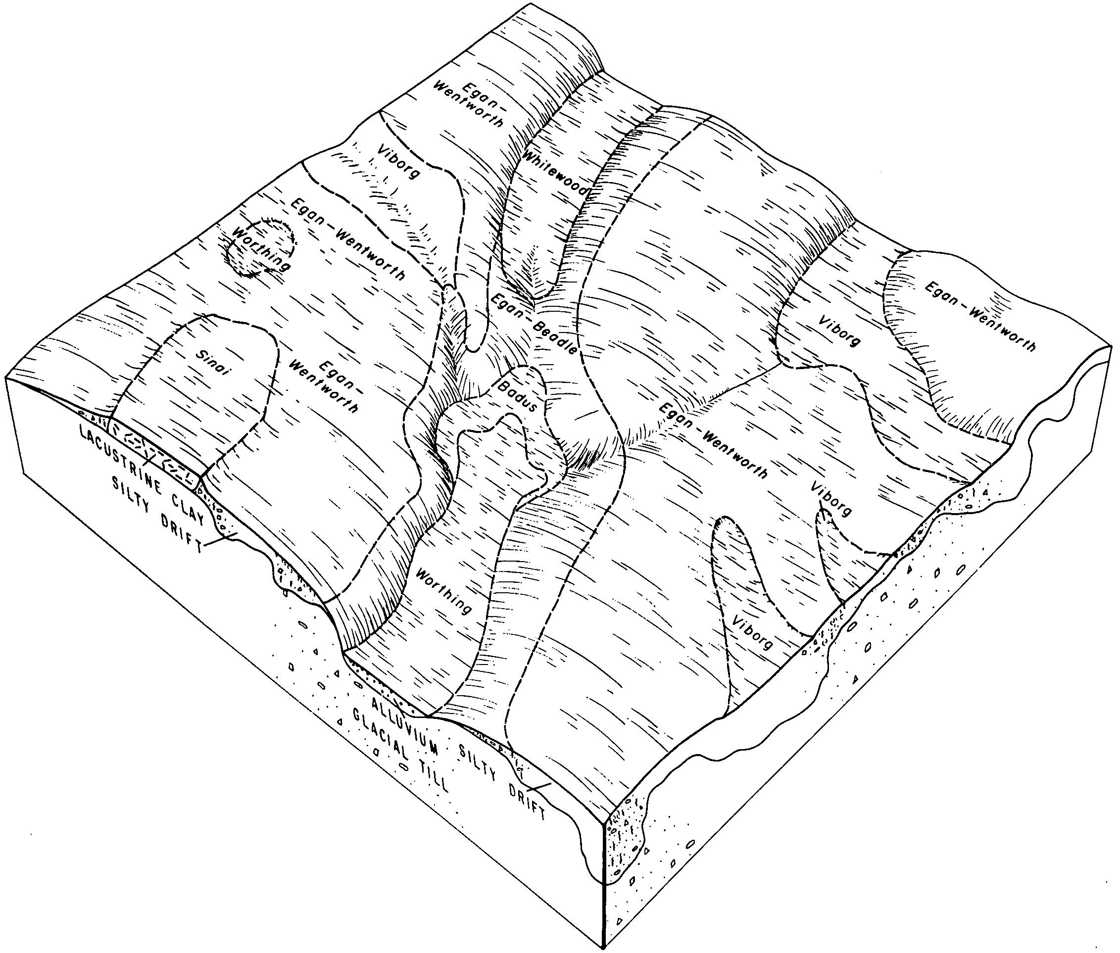
Sinai clay, 2 to 6 percent slopes | SlB | 8921 | 397321 | fbft | mn041 | 1970 | 1:12000 |
Sinai clay, 0 to 2 percent slopes | SlA | 835 | 397320 | fbfs | mn041 | 1970 | 1:12000 |
Sinai silty clay, 1 to 6 percent slopes | 212B | 672 | 398026 | fc5k | mn051 | 1974 | 1:20000 |
Sinai silty clay, 6 to 12 percent slopes | 212C | 300 | 398027 | fc5l | mn051 | 1974 | 1:20000 |
Sinai-Ludden, flooded, clays, very-fine family, 0 to 6 percent slopes | I137B | 2455 | 2798882 | 21x2v | mn069 | 2007 | 1:12000 |
Sinai silty clay loam, 1 to 3 percent slopes | 212A | 2036 | 430271 | gfqq | mn073 | 1994 | 1:20000 |
Sinai silty clay, 3 to 6 percent slopes | 212B | 976 | 430272 | gfqr | mn073 | 1994 | 1:20000 |
Sinai silty clay, 1 to 3 percent slopes | 212 | 8 | 1859027 | 20dgm | mn083 | 2008 | 1:12000 |
Sinai silty clay, levees, 0 to 6 percent slopes | I475B | 810 | 2799007 | 2pg9f | mn089 | 1994 | 1:20000 |
Sinai silty clay, levees, 0 to 6 percent slopes | I475B | 555 | 2799086 | 2pg9f | mn107 | 1970 | 1:20000 |
Sinai silty clay, levees, 0 to 6 percent slopes | I475B | 1039 | 2799710 | 2pg9f | mn119 | 1996 | 1:20000 |
Sinai silty clay, 2 to 6 percent slopes | J10B | 243 | 434775 | glf0 | mn151 | 2000 | 1:12000 |
Sinai silty clay, 0 to 2 percent slopes | J10A | 202 | 434774 | gldz | mn151 | 2000 | 1:12000 |
Sinai silty clay, levees, 0 to 6 percent slopes | I475B | 512 | 2800431 | 2pg9f | mn167 | 1985 | 1:20000 |
Sinai silty clay loam, 0 to 2 percent slopes, colluvial | G607A | 1084 | 2573641 | 2q5sc | nd003 | 1988 | 1:20000 |
Sinai silty clay loam, 2 to 6 percent slopes, colluvial | G607B | 579 | 2573642 | 2q5sd | nd003 | 1988 | 1:20000 |
Sinai silty clay, levees, 0 to 6 percent slopes | I475B | 2002 | 2640839 | 2pg9f | nd017 | 1983 | 1:20000 |
Sinai silty clay loam, 0 to 2 percent slopes | G516A | 1408 | 2575348 | 2q5p7 | nd021 | 1989 | 1:20000 |
Sinai silty clay loam, 0 to 2 percent slopes | G516A | 16 | 2577171 | 2q5p7 | nd055 | 1974 | 1:20000 |
Sinai silty clay, wet, 0 to 2 percent slopes | G511A | 1734 | 2577423 | 2q5p5 | nd077 | 2005 | 1:12000 |
Sinai, wet-Harmony silty clay loams, 0 to 2 percent slopes | G515A | 655 | 2577391 | 2q5p6 | nd077 | 2005 | 1:12000 |
Sinai silty clay, 0 to 2 percent slopes | J222A | 111 | 1544946 | 1nvmz | nd077 | 2005 | 1:12000 |
Sinai-Harmony silty clay loams, 0 to 2 percent slopes | J215A | 80 | 1544945 | 1nvmy | nd077 | 2005 | 1:12000 |
Sinai, wet-Harmony silty clay loams, 0 to 2 percent slopes | G515A | 313 | 2579436 | 2q5p6 | nd081 | 1959 | 1:12000 |
Sinai silty clay, wet, 0 to 2 percent slopes | G511A | 199 | 2579529 | 2q5p5 | nd081 | 1959 | 1:12000 |
Sinai silty clay loam, 0 to 2 percent slopes | G516A | 165 | 2581388 | 2q5p7 | nd093 | 1990 | 1:24000 |
Sinai silty clay, levees, 0 to 6 percent slopes | I475B | 3335 | 2642493 | 2pg9f | nd097 | 1974 | 1:20000 |
Sinai silty clay, levees, 0 to 6 percent slopes | I475B | 2759 | 2642926 | 2pg9f | nd099 | 1967 | 1:20000 |
Sinai silty clay, 0 to 2 percent slopes | SnA | 521 | 417786 | 2xhc9 | sd025 | 1992 | 1:20000 |
Sinai silty clay, 2 to 6 percent slopes | SnB | 440 | 417787 | 2xhcg | sd025 | 1992 | 1:20000 |
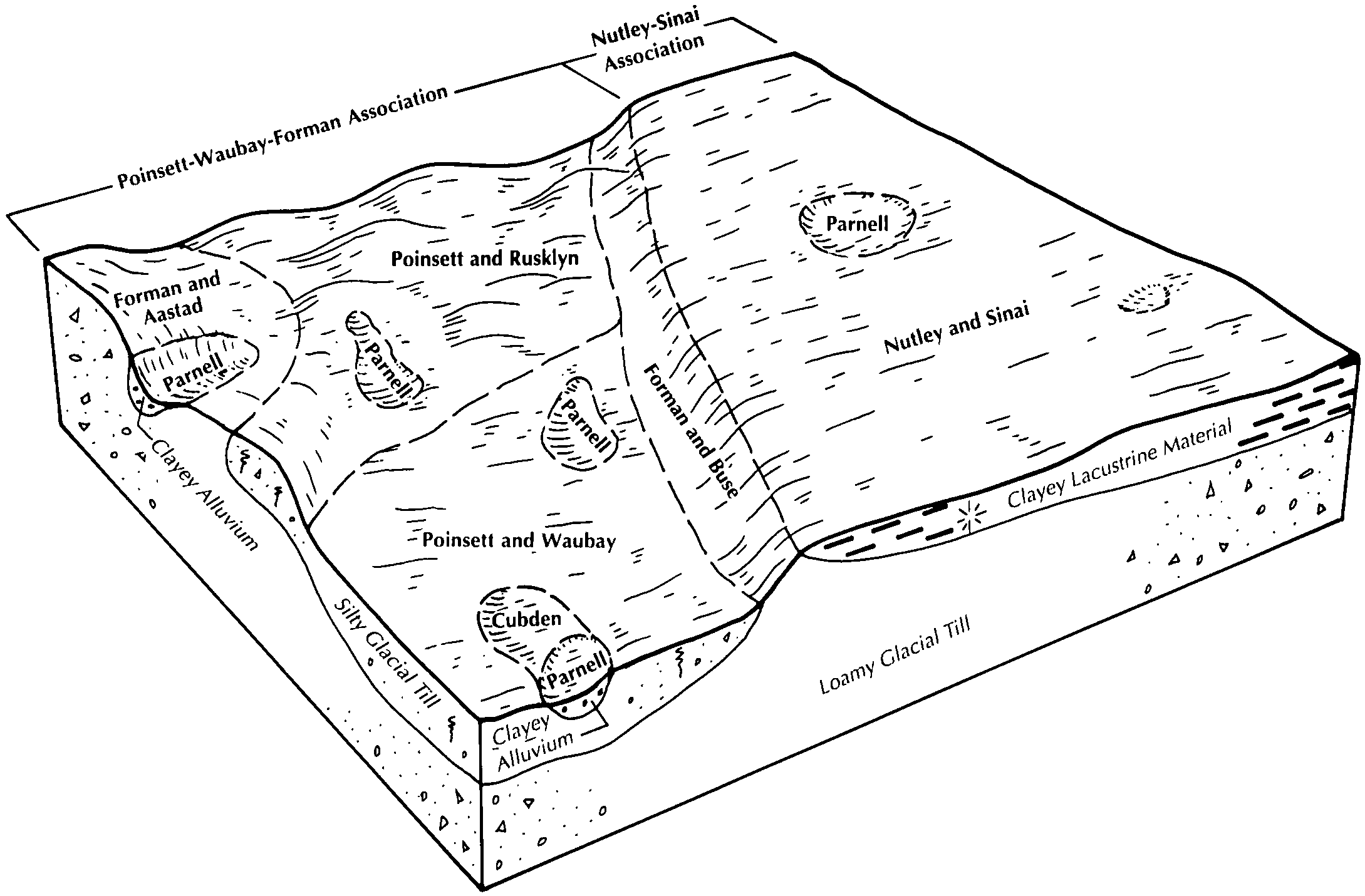
Nutley-Sinai silty clays, 2 to 6 percent slopes | NsB | 5306 | 417112 | 30t3g | sd037 | 1992 | 1:20000 |
Sinai-Nutley silty clays, 0 to 2 percent slopes | SaA | 1364 | 417130 | 30t3f | sd037 | 1992 | 1:20000 |
Sinai silty clay, 0 to 2 percent slopes | SbA | 3155 | 416899 | 30t3b | sd039 | 1992 | 1:20000 |
Sinai silty clay, 2 to 6 percent slopes | SbB | 2619 | 416900 | 30t3c | sd039 | 1992 | 1:20000 |
Nutley-Sinai silty clays, 6 to 12 percent slopes | NsC | 1073 | 416880 | 30t3h | sd039 | 1992 | 1:20000 |
Sinai silty clay, 0 to 2 percent slopes | SnA | 1927 | 417512 | 2xhc9 | sd077 | 1992 | 1:20000 |
Sinai silty clay, 2 to 6 percent slopes | SkB | 4992 | 416607 | 2xhcg | sd091 | 1970 | 1:20000 |
Sinai silty clay, 0 to 2 percent slopes | SkA | 2505 | 416606 | 2xhc9 | sd091 | 1970 | 1:20000 |
Sinai silty clay, 6 to 9 percent slopes | SkC | 852 | 416608 | 30t3d | sd091 | 1970 | 1:20000 |
Sinai silty clay, 0 to 2 percent slopes | SnA | 2696 | 417871 | 2xhc9 | sd109 | 1977 | 1:20000 |
Sinai silty clay, 2 to 6 percent slopes | SnB | 734 | 417872 | 2xhcg | sd109 | 1977 | 1:20000 |
