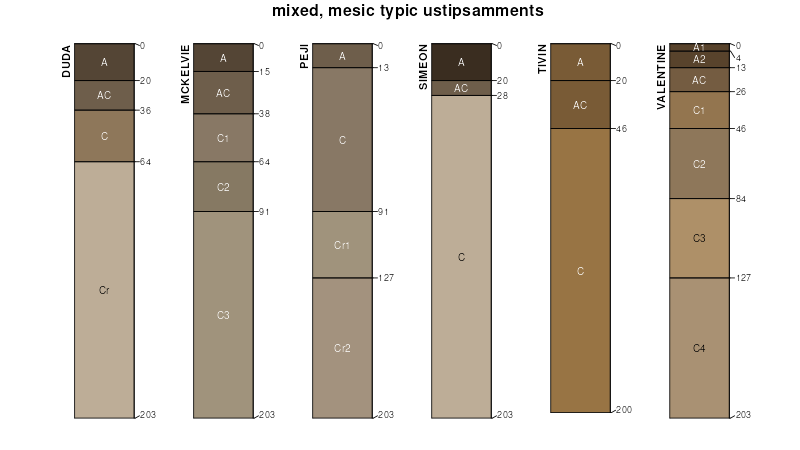
| Simeon loamy sand, 5 to 15 percent slopes | 2798 | 9462 | 1150546 | 31rhm | ks109 | 1962 | 1:24000 |
Simeon loamy sand, 5 to 15 percent slopes | 2798 | 449 | 1150010 | 31rhl | ks179 | 1982 | 1:24000 |
Simeon sandy loam, 0 to 3 percent slopes | 8932 | 387 | 2216107 | 2dd1b | ne001 | 1970 | 1:20000 |
Valentine-Simeon complex, moist, 0 to 9 percent slopes | 4877 | 1983 | 2876697 | 2v9w8 | ne003 | 1975 | 1:20000 |
Valentine-Simeon complex, 6 to 11 percent slopes | 4879 | 1846 | 427011 | gbbk | ne003 | 1975 | 1:20000 |
Valentine-Simeon sands, 3 to 9 percent slopes | 4881 | 403 | 2215953 | 2dcwc | ne003 | 1975 | 1:20000 |
Simeon sand, 6 to 30 percent slopes, eroded | 8931 | 217 | 2215986 | 2dcxf | ne003 | 1975 | 1:20000 |
Simeon sandy loam, 0 to 6 percent slopes | 8933 | 21 | 2215988 | 2dcxh | ne003 | 1975 | 1:20000 |
Simeon sand, 0 to 3 percent slopes | 8929 | 4047 | 1699498 | 2v9wf | ne009 | 1988 | 1:20000 |
Valentine-Simeon complex, moist, 0 to 9 percent slopes | 4877 | 1100 | 1699510 | 2v9w8 | ne009 | 1988 | 1:20000 |
Simeon sand, 3 to 30 percent slopes | 8930 | 609 | 1699499 | 319nd | ne009 | 1988 | 1:20000 |
Simeon-Valentine complex, 0 to 9 percent slopes | 8939 | 64 | 2219157 | 2v9w9 | ne009 | 1988 | 1:20000 |
Simeon-Valentine complex, 3 to 30 percent slopes, eroded | 8940 | 8497 | 357669 | d05q | ne015 | 1976 | 1:20000 |
Simeon loamy sand, 0 to 3 percent slopes | 8925 | 2988 | 357667 | 2v9wg | ne015 | 1976 | 1:20000 |
Simeon-Valentine loamy sands, 0 to 6 percent slopes | 8946 | 2751 | 357668 | d05p | ne015 | 1976 | 1:20000 |
Simeon-Valentine complex, 0 to 9 percent slopes | 8939 | 18405 | 2876701 | 2v9w9 | ne017 | 1987 | 1:20000 |
Valentine-Simeon complex, 9 to 40 percent slopes, eroded | 4880 | 7184 | 100041 | 3c34 | ne017 | 1987 | 1:20000 |
Simeon loamy sand, 0 to 3 percent slopes | 8925 | 5801 | 100025 | 2v9wg | ne017 | 1987 | 1:20000 |
Simeon loamy sand, 3 to 11 percent slopes | 8928 | 2674 | 100026 | 3c2n | ne017 | 1987 | 1:20000 |
Simeon sandy loam, 0 to 3 percent slopes | 8932 | 552 | 1700078 | 1v227 | ne019 | 1967 | 1:20000 |
Simeon loamy sand, 0 to 3 percent slopes | 8925 | 1295 | 1691325 | 1tryw | ne023 | 1979 | 1:20000 |
Simeon-Talmo-Ortello complex, 11 to 30 percent slopes | 8937 | 6069 | 427134 | gbgj | ne027 | 1982 | 1:20000 |
Simeon sand, 6 to 30 percent slopes, eroded | 8931 | 14 | 2216823 | 2ddsf | ne027 | 1982 | 1:20000 |
Simeon-Valentine complex, 0 to 9 percent slopes | 8939 | 18574 | 100431 | 2v9w9 | ne031 | 1995 | 1:24000 |
Simeon sand, 0 to 3 percent slopes | 8929 | 8546 | 100430 | 2v9wf | ne031 | 1995 | 1:24000 |
Simeon-Valentine complex, 9 to 24 percent slopes | 8941 | 2949 | 100432 | 2v9wc | ne031 | 1995 | 1:24000 |
Simeon loamy sand, 3 to 30 percent slopes | 8927 | 196 | 1699803 | 1v1sc | ne071 | 1984 | 1:20000 |
Simeon loamy sand, 0 to 3 percent slopes | 8925 | 361 | 1699964 | 2v9wg | ne077 | 1987 | 1:20000 |
Simeon sandy loam, 0 to 3 percent slopes | 8932 | 1662 | 1700176 | 1v25d | ne079 | 2003 | 1:12000 |
Valentine-Simeon sands, 9 to 30 percent slopes, eroded | 4882 | 15382 | 100169 | 3c78 | ne089 | 1981 | 1:20000 |
Simeon loamy sand, 0 to 3 percent slopes | 8925 | 12349 | 100156 | 2v9wg | ne089 | 1981 | 1:20000 |
Valentine-Simeon sands, 3 to 9 percent slopes | 4881 | 5806 | 100168 | 3c77 | ne089 | 1981 | 1:20000 |
Simeon sand, 0 to 3 percent slopes | 8929 | 2816 | 100155 | 2v9wf | ne089 | 1981 | 1:20000 |
Simeon sand, 6 to 30 percent slopes, eroded | 8931 | 1279 | 2219610 | 2dhpb | ne089 | 1981 | 1:20000 |
Simeon-Valentine sands, 11 to 60 percent slopes, eroded | 8947 | 49 | 2219626 | 2dhpv | ne089 | 1981 | 1:20000 |
Simeon loamy sand, 0 to 3 percent slopes | 8925 | 3562 | 99743 | 3bsj | ne093 | 1968 | 1:12000 |
Simeon sandy loam, 0 to 3 percent slopes | 8932 | 9237 | 1691871 | 1tsjh | ne099 | 1982 | 1:20000 |
Simeon-Holt variant-Ronson complex, 6 to 17 percent slopes | 8935 | 30295 | 357735 | d07v | ne103 | 1977 | 1:20000 |
Simeon-Valentine loamy sands, 0 to 3 percent slopes | 8945 | 4917 | 357737 | d07x | ne103 | 1977 | 1:20000 |
Simeon-Valentine fine sands, 6 to 17 percent slopes, eroded | 8943 | 2008 | 357736 | d07w | ne103 | 1977 | 1:20000 |
Simeon-Valentine loamy sands, 0 to 6 percent slopes | 8946 | 8 | 2217595 | 2dflb | ne103 | 1977 | 1:20000 |
Simeon sand, 6 to 30 percent slopes, eroded | 8931 | 10074 | 1144289 | 17dqk | ne107 | 1989 | 1:20000 |
Simeon-Thurman complex, 6 to 30 percent slopes | 8938 | 6816 | 1144292 | 17dqn | ne107 | 1989 | 1:20000 |
Simeon loamy sand, 0 to 6 percent slopes | 8926 | 2537 | 1144290 | 17dql | ne107 | 1989 | 1:20000 |
Simeon sandy loam, 0 to 6 percent slopes | 8933 | 2269 | 1144291 | 17dqm | ne107 | 1989 | 1:20000 |
Simeon sand, 0 to 3 percent slopes | 8929 | 1862 | 1699549 | 2v9wf | ne115 | 1986 | 1:20000 |
Boelus sandy substratum-Simeon loamy sands, 0 to 3 percent slopes | 6644 | 1505 | 1699519 | 319nc | ne115 | 1986 | 1:20000 |
Valentine-Simeon complex, moist, 0 to 9 percent slopes | 4877 | 1130 | 1699563 | 2v9w8 | ne115 | 1986 | 1:20000 |
Simeon sand, 3 to 30 percent slopes | 8930 | 382 | 1699550 | 319nd | ne115 | 1986 | 1:20000 |
Simeon loamy sand, 0 to 3 percent slopes | 8925 | 1134 | 1709681 | 1vd20 | ne121 | 1978 | 1:20000 |
Simeon loamy sand, 0 to 3 percent slopes | 8925 | 38 | 2228974 | 2dtfd | ne125 | 1958 | 1:20000 |
Simeon sandy loam, 0 to 3 percent slopes | 8932 | 299 | 2219471 | 2dhjv | ne137 | 1967 | 1:20000 |
Simeon sandy loam, 3 to 11 percent slopes | 8934 | 742 | 427605 | gbyq | ne139 | 1970 | 1:20000 |
Simeon loamy sand, 0 to 3 percent slopes | 8925 | 828 | 427677 | gc11 | ne141 | 1984 | 1:20000 |
Simeon loamy sand, 0 to 3 percent slopes | 8925 | 2480 | 2218993 | 2dh1f | ne143 | 1967 | 1:20000 |
Simeon-Valentine sands, 11 to 60 percent slopes, eroded | 8947 | 8121 | 100256 | 3cb2 | ne149 | 1982 | 1:20000 |
Simeon loamy sand, 0 to 3 percent slopes | 8925 | 4952 | 100254 | 2v9wg | ne149 | 1982 | 1:20000 |
Valentine-Simeon complex, 9 to 40 percent slopes, eroded | 4880 | 4541 | 2219842 | 2dhxt | ne149 | 1982 | 1:20000 |
Simeon-Meadin complex, 0 to 9 percent slopes | 8936 | 3286 | 100255 | 3cb1 | ne149 | 1982 | 1:20000 |
Simeon loamy sand, 3 to 11 percent slopes | 8928 | 63 | 2219840 | 2dhxr | ne149 | 1982 | 1:20000 |
Simeon-Valentine complex, 9 to 24 percent slopes | 8941 | 346 | 2605684 | 2v9wc | ne171 | 1963 | 1:24000 |
Simeon-Valentine complex, 0 to 9 percent slopes | 8939 | 302 | 2605683 | 2v9w9 | ne171 | 1963 | 1:24000 |
Simeon sand, 0 to 3 percent slopes | 8929 | 91 | 2605682 | 2v9wf | ne171 | 1963 | 1:24000 |
Simeon loamy sand, 3 to 30 percent slopes | 8927 | 892 | 1699911 | 1v1wv | ne175 | 1983 | 1:20000 |
Simeon loamy sand, 0 to 3 percent slopes | 8925 | 201 | 1699910 | 2v9wg | ne175 | 1983 | 1:20000 |
