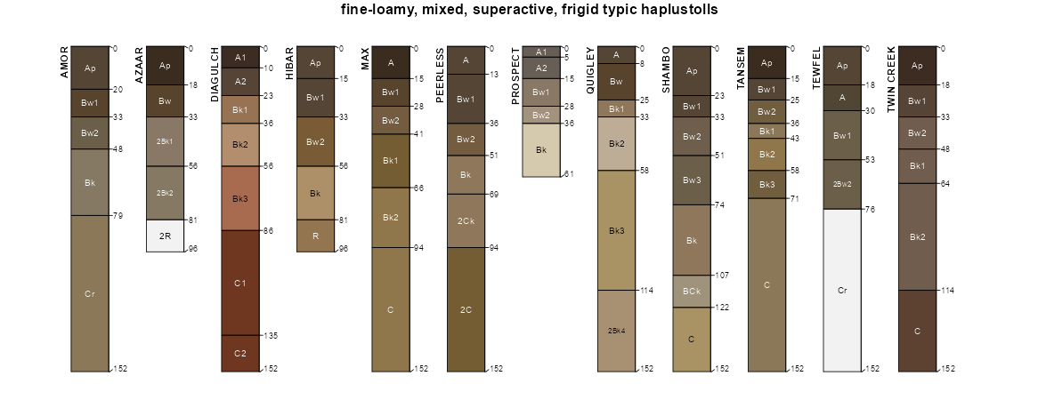
| Shambo-Mowbray-Parchin complex, 4 to 25 percent slopes | 231D | 15325 | 343036 | chyp | mt011 | 1992 | 1:24000 |
Shambo-Noonan loams, 4 to 15 percent slopes | 131C | 4645 | 342871 | chsc | mt011 | 1992 | 1:24000 |
Shambo-Lisk-Dast complex, 8 to 25 percent slopes | 802E | 12425 | 343692 | cjmv | mt017 | 1995 | 1:24000 |
Tally-Shambo complex, 2 to 8 percent slopes | 342C | 7351 | 343394 | cjb7 | mt017 | 1995 | 1:24000 |
Shambo-Doney loams, 2 to 8 percent slopes | 511C | 6204 | 343517 | cjg6 | mt017 | 1995 | 1:24000 |
Shambo loam, 2 to 8 percent slopes | 51C | 4188 | 343518 | cjg7 | mt017 | 1995 | 1:24000 |
Shambo loam, 4 to 8 percent slopes | 59C | 402 | 1487182 | 1lxjm | mt021 | 1971 | 1:24000 |
Shambo loam, 2 to 4 percent slopes | 59B | 377 | 1487183 | 1lxjn | mt021 | 1971 | 1:24000 |
Shambo loam, 0 to 2 percent slopes | 59A | 228 | 1487184 | 1lxjp | mt021 | 1971 | 1:24000 |
Shambo loam, 2 to 6 percent slopes | E2145B | 2404 | 342200 | 1vztf | mt025 | 1991 | 1:24000 |
Farnuf loam, 0 to 4 percent slopes | 97 | 12916 | 342602 | chhp | mt027 | 1979 | 1:24000 |
Shambo loam, 2 to 8 percent slopes | 200 | 8903 | 342436 | chbb | mt027 | 1979 | 1:24000 |
Shambo loam, 0 to 2 percent slopes | 199 | 3300 | 342433 | chb7 | mt027 | 1979 | 1:24000 |
Shambo-Labre complex, 2 to 8 percent slopes | 201 | 1441 | 342437 | chbc | mt027 | 1979 | 1:24000 |
Shambo-Labre complex, 8 to 15 percent slopes | 202 | 985 | 342438 | chbd | mt027 | 1979 | 1:24000 |
Shambo-Cambert loams, 2 to 8 percent slopes | 127 | 35591 | 344324 | ck97 | mt055 | 1981 | 1:24000 |
Shambo loam, 0 to 4 percent slopes | 124 | 15259 | 344321 | ck94 | mt055 | 1981 | 1:24000 |
Shambo loam, 4 to 8 percent slopes | 125 | 8765 | 344322 | ck95 | mt055 | 1981 | 1:24000 |
Shambo-Cabba loams, 8 to 15 percent slopes | 126 | 820 | 344323 | ck96 | mt055 | 1981 | 1:24000 |
Shambo-Korchea-Barvon loams, 2 to 8 percent slopes | 255C | 12214 | 344528 | ckht | mt065 | 1996 | 1:24000 |
Barvon-Cabba-Shambo loams, 4 to 15 percent slopes | 255D | 6939 | 344529 | ckhv | mt065 | 1996 | 1:24000 |
Shambo loam, 2 to 8 percent slopes | 294C | 2298 | 344559 | ckjt | mt065 | 1996 | 1:24000 |
Shambo loam, 0 to 4 percent slopes | 114 | 525 | 344791 | cks9 | mt079 | 1986 | 1:24000 |
Shambo loam, 4 to 8 percent slopes | 113 | 282 | 344790 | cks8 | mt079 | 1986 | 1:24000 |
Shambo loam, 2 to 4 percent slopes | ShB | 30603 | 345357 | clck | mt083 | 1973 | 1:24000 |
Shambo loam, 0 to 2 percent slopes | ShA | 27265 | 345356 | clcj | mt083 | 1973 | 1:24000 |
Shambo loam, 4 to 8 percent slopes | ShC | 4425 | 2837899 | clcl | mt083 | 1973 | 1:24000 |
Shambo loam, 6 to 9 percent slopes | E2147C | 3451 | 345358 | 2q511 | mt083 | 1973 | 1:24000 |
Shambo loam, 4 to 8 percent slopes | 59C | 332 | 2216042 | 2dcz7 | mt083 | 1973 | 1:24000 |
Shambo loam, 2 to 4 percent slopes | 59B | 33 | 2216040 | 2dcz5 | mt083 | 1973 | 1:24000 |
Shambo loam | Sh | 2393 | 348869 | cq0v | mt091 | 1971 | 1:24000 |
Shambo loam, 0 to 4 percent slopes | 74B | 2357 | 345266 | cl8m | mt101 | 1992 | 1:24000 |
Shambo-Fairway loams, 0 to 2 percent slopes | 743A | 2013 | 345265 | cl8l | mt101 | 1992 | 1:24000 |
Shambo-Korchea-Barvon loams, 2 to 8 percent slopes | 255C | 40 | 1913569 | ckht | mt111 | 1966 | 1:20000 |
Shambo-Amor-Cabba loams, 15 to 45 percent slopes | 745F | 12609 | 346905 | cmzh | mt615 | 1992 | 1:24000 |
Shambo-Straw loams, 0 to 4 percent slopes | 741B | 3932 | 346904 | cmzg | mt615 | 1992 | 1:24000 |
Shambo loam, 2 to 8 percent slopes | 74C | 1925 | 346907 | cmzk | mt615 | 1992 | 1:24000 |
Shambo loam, 4 to 15 percent slope | 643D | 1456 | 1902209 | 21vdl | mt624 | 2021 | 1:24000 |
Absarokee-Shambo complex, 8 to 15 percent slopes | 184D | 1408 | 347308 | cndh | mt624 | 2021 | 1:24000 |
Shambo loam, 2 to 4 percent slopes | 643B | 1131 | 1902135 | 21vb6 | mt624 | 2021 | 1:24000 |
Shambo-Cabba loams, 8 to 35 percent slopes | 25E | 212 | 2485111 | 2pdyw | mt624 | 2021 | 1:24000 |
Shambo-Tally complex, 2 to 8 percent slopes | 14C | 5 | 3176847 | v6j0 | mt624 | 2021 | 1:24000 |
Shambo-Cabba complex, 8 to 35 percent slopes | 125E | 3678 | 2496380 | 2pqkd | mt637 | 2014 | 1:24000 |
Shambo-Cabba complex, 8 to 35 percent slopes, foothills | 25E | 1396 | 148010 | 4z0j | mt637 | 2014 | 1:24000 |
Shambo-Tally complex, 2 to 8 percent slopes | 14C | 362 | 780828 | v6j0 | mt637 | 2014 | 1:24000 |
Shambo loam, 2 to 4 percent slopes | 643B | 58 | 2517341 | 21vb6 | mt637 | 2014 | 1:24000 |
Shambo loam, 4 to 8 percent slopes | 224C | 44 | 1858526 | 20cyg | mt637 | 2014 | 1:24000 |
Shambo loam, 4 to 8 percent slopes | 224C | 2929 | 149779 | 50vl | mt639 | 2000 | 1:24000 |
Shambo loam, 8 to 15 percent slopes | 224D | 2003 | 149780 | 50vm | mt639 | 2000 | 1:24000 |
Shawmut-Shambo complex, 2 to 8 percent slopes | 304C | 1417 | 149872 | 50yl | mt639 | 2000 | 1:24000 |
Shawmut-Shambo complex, 8 to 15 percent slopes | 304D | 733 | 149873 | 50ym | mt639 | 2000 | 1:24000 |
Shambo clay loam, calcareous, 4 to 8 percent slopes | 279C | 422 | 149849 | 50xv | mt639 | 2000 | 1:24000 |
Shambo loam, 0 to 4 percent slopes | 224B | 356 | 149778 | 50vk | mt639 | 2000 | 1:24000 |
Castner-Shambo complex, 8 to 15 percent slopes | 192D | 154 | 149733 | 50t3 | mt639 | 2000 | 1:24000 |
Absarokee-Shambo loams, 8 to 15 percent slopes | 184D | 153 | 149722 | 50sr | mt639 | 2000 | 1:24000 |
Shambo gravelly clay loam, 2 to 8 percent slopes | 189C | 68 | 149729 | 50sz | mt639 | 2000 | 1:24000 |
Shambo-Doney-Cabba loams, 8 to 35 percent slopes | 166 | 24048 | 347993 | cp3l | mt649 | 1985 | 1:24000 |
Shambo-Doney loams, 4 to 15 percent slopes | 165 | 10071 | 347992 | cp3k | mt649 | 1985 | 1:24000 |
Shambo loam, 2 to 8 percent slopes | 162 | 9347 | 347989 | cp3g | mt649 | 1985 | 1:24000 |
Shambo-Doney-Sagedale complex, 8 to 35 percent slopes | 167 | 4933 | 347994 | cp3m | mt649 | 1985 | 1:24000 |
Shambo loam, 8 to 15 percent slopes | 163 | 3675 | 347990 | cp3h | mt649 | 1985 | 1:24000 |
Bitton-Shambo complex, 4 to 15 percent slopes | 26 | 2472 | 348055 | cp5l | mt649 | 1985 | 1:24000 |
Castner-Shambo complex, 2 to 15 percent slopes | 61 | 2158 | 348094 | cp6v | mt649 | 1985 | 1:24000 |
Twin Creek-Shambo loams, 2 to 8 percent slopes | 179 | 1910 | 348007 | cp41 | mt649 | 1985 | 1:24000 |
Shambo-Bitton-Cabba complex, 8 to 15 percent slopes | 164 | 1682 | 347991 | cp3j | mt649 | 1985 | 1:24000 |
Shambo loam, 0 to 2 percent slopes | 161 | 854 | 347988 | cp3f | mt649 | 1985 | 1:24000 |
Shambo loam, 4 to 8 percent slopes | 224C | 16 | 361449 | d43n | mt655 | 1975 | 1:24000 |
Shambo-Amor loams, 2 to 8 percent slopes | 384C | 7473 | 348610 | cprh | mt657 | 1990 | 1:24000 |
Shambo-Amor loams, 8 to 15 percent slopes | 384D | 5783 | 348611 | cprj | mt657 | 1990 | 1:24000 |
Deville-Sawicki-Shambo complex, 15 to 60 percent slopes | 5641F | 3065 | 696051 | rc98 | mt669 | | 1:24000 |
Wickes-Shambo-Whitlash complex, 8 to 35 percent slopes | 5543E | 347 | 699260 | rgms | mt669 | | 1:24000 |
Amor-Shambo loams, 3 to 6 percent slopes | E2803B | 27240 | 2525751 | 1vzv0 | nd001 | 1983 | 1:20000 |
Shambo loam, 0 to 2 percent slopes | E2145A | 16260 | 2525745 | 1vztd | nd001 | 1983 | 1:20000 |
Shambo loam, 2 to 6 percent slopes | E2145B | 13193 | 2525746 | 1vztf | nd001 | 1983 | 1:20000 |
Cabba-Chama-Shambo loams, 9 to 50 percent slopes | E2617F | 7664 | 2525747 | 1vzts | nd001 | 1983 | 1:20000 |
Shambo loam, gravelly substratum, 0 to 2 percent slopes | E4571A | 2762 | 2755667 | 2r4fj | nd001 | 1983 | 1:20000 |
Shambo loam, gravelly substratum, 2 to 6 percent slopes | E4571B | 1234 | 2755668 | 2r4fk | nd001 | 1983 | 1:20000 |
Stady-Shambo, gravelly substratum loams, 0 to 2 percent slopes | E4570A | 14 | 2755666 | 2r4fh | nd001 | 1983 | 1:20000 |
Amor-Shambo loams, 3 to 6 percent slopes | E2803B | 5816 | 1715188 | 1vzv0 | nd007 | 1998 | 1:24000 |
Cabba-Chama-Shambo loams, 9 to 50 percent slopes | E2617F | 2757 | 2699060 | 1vzts | nd007 | 1998 | 1:24000 |
Arikara-Shambo-Cabba loams, 9 to 70 percent slopes | E2725F | 1162 | 2699062 | 1vztv | nd007 | 1998 | 1:24000 |
Shambo loam, 0 to 2 percent slopes | E2145A | 996 | 1715180 | 1vztd | nd007 | 1998 | 1:24000 |
Shambo loam, 2 to 6 percent slopes | E2145B | 689 | 2699057 | 1vztf | nd007 | 1998 | 1:24000 |
Shambo loam, gravelly substratum, 0 to 2 percent slopes | E4571A | 16 | 2758433 | 2r4fj | nd007 | 1998 | 1:24000 |
Amor-Shambo loams, 3 to 6 percent slopes | E2803B | 27926 | 2563516 | 1vzv0 | nd011 | 1969 | 1:20000 |
Cabba-Chama-Shambo loams, 9 to 50 percent slopes | E2617F | 10311 | 2563538 | 1vzts | nd011 | 1969 | 1:20000 |
Shambo loam, 0 to 2 percent slopes | E2145A | 5512 | 2758450 | 1vztd | nd011 | 1969 | 1:20000 |
Stady-Shambo, gravelly substratum loams, 0 to 2 percent slopes | E4570A | 2038 | 2563616 | 2r4fh | nd011 | 1969 | 1:20000 |
Shambo-Arnegard loams, 0 to 2 percent slopes | E2117A | 2001 | 2563612 | 2q50z | nd011 | 1969 | 1:20000 |
Shambo-Arnegard loams, 2 to 6 percent slopes | E2117B | 1589 | 2563613 | 2q510 | nd011 | 1969 | 1:20000 |
Shambo loam, 2 to 6 percent slopes | E2145B | 1330 | 2758451 | 1vztf | nd011 | 1969 | 1:20000 |
Shambo loam, gravelly substratum, 0 to 2 percent slopes | E4571A | 1000 | 2563610 | 2r4fj | nd011 | 1969 | 1:20000 |
Reeder-Shambo loams, 3 to 6 percent slopes | ReB | 185 | 992881 | 12b5f | nd011 | 1969 | 1:20000 |
Amor-Shambo loams, 3 to 6 percent slopes | AmB | 150 | 992781 | 12b26 | nd011 | 1969 | 1:20000 |
Shambo loam, gravelly substratum, 2 to 6 percent slopes | E4571B | 63 | 2563611 | 2r4fk | nd011 | 1969 | 1:20000 |
Reeder-Shambo loams, 0 to 3 percent slopes | ReA | 38 | 992880 | 12b5d | nd011 | 1969 | 1:20000 |
Shambo-Belfield-Rhoades loams, 0 to 2 percent slopes | SmA | 11 | 992905 | 12b66 | nd011 | 1969 | 1:20000 |
Amor-Shambo loams, 3 to 6 percent slopes | E2803B | 36 | 2661697 | 1vzv0 | nd015 | 1967 | 1:20000 |
Cabba-Chama-Shambo loams, 9 to 50 percent slopes | E2617F | 71036 | 2525635 | 1vzts | nd025 | 1981 | 1:20000 |
Amor-Shambo loams, 3 to 6 percent slopes | E2803B | 18434 | 1714650 | 1vzv0 | nd025 | 1981 | 1:20000 |
Arikara-Shambo-Cabba loams, 9 to 70 percent slopes | E2725F | 9912 | 1714645 | 1vztv | nd025 | 1981 | 1:20000 |
Shambo loam, 0 to 2 percent slopes | E2145A | 5053 | 1714636 | 1vztd | nd025 | 1981 | 1:20000 |
Shambo loam, 2 to 6 percent slopes | E2145B | 4390 | 2707202 | 1vztf | nd025 | 1981 | 1:20000 |
Shambo loam, gravelly substratum, 0 to 2 percent slopes | E4571A | 205 | 2758477 | 2r4fj | nd025 | 1981 | 1:20000 |
Shambo loam, gravelly substratum, 2 to 6 percent slopes | E4571B | 99 | 2758478 | 2r4fk | nd025 | 1981 | 1:20000 |
Shambo loam, 0 to 2 percent slopes | E2145A | 4177 | 2661777 | 1vztd | nd029 | 1979 | 1:20000 |
Shambo loam, 2 to 6 percent slopes | E2145B | 1799 | 2661778 | 1vztf | nd029 | 1979 | 1:20000 |
Shambo loam, 0 to 2 percent slopes | C480A | 860 | 2564349 | 2q6lm | nd029 | 1979 | 1:20000 |
Shambo loam, 2 to 6 percent slopes | C480B | 687 | 2564294 | 2q2k0 | nd029 | 1979 | 1:20000 |
Amor-Shambo loams, 3 to 6 percent slopes | E2803B | 113 | 2661782 | 1vzv0 | nd029 | 1979 | 1:20000 |
Shambo loam, gravelly substratum, 2 to 6 percent slopes | E4571B | 23 | 2661823 | 2r4fk | nd029 | 1979 | 1:20000 |
Amor-Shambo loams, 3 to 6 percent slopes | E2803B | 3491 | 2707296 | 1vzv0 | nd033 | 1985 | 1:24000 |
Shambo loam, 2 to 6 percent slopes | E2145B | 2380 | 2759734 | 1vztf | nd033 | 1985 | 1:24000 |
Shambo loam, 0 to 2 percent slopes | E2145A | 2106 | 2759735 | 1vztd | nd033 | 1985 | 1:24000 |
Shambo loam, gravelly substratum, 0 to 2 percent slopes | E4571A | 700 | 2707310 | 2r4fj | nd033 | 1985 | 1:24000 |
Cabba-Chama-Shambo loams, 9 to 50 percent slopes | E2617F | 138 | 2759739 | 1vzts | nd033 | 1985 | 1:24000 |
Shambo loam, gravelly substratum, 2 to 6 percent slopes | E4571B | 87 | 2707311 | 2r4fk | nd033 | 1985 | 1:24000 |
Arikara-Shambo-Cabba loams, 9 to 70 percent slopes | E2725F | 61 | 2759741 | 1vztv | nd033 | 1985 | 1:24000 |
Amor-Shambo loams, 3 to 6 percent slopes | E2803B | 82832 | 1715499 | 1vzv0 | nd037 | 1985 | 1:20000 |
Cabba-Chama-Shambo loams, 9 to 50 percent slopes | E2617F | 42696 | 2525636 | 1vzts | nd037 | 1985 | 1:20000 |
Shambo loam, 0 to 2 percent slopes | E2145A | 21939 | 1715492 | 1vztd | nd037 | 1985 | 1:20000 |
Shambo loam, 2 to 6 percent slopes | E2145B | 10847 | 2525881 | 1vztf | nd037 | 1985 | 1:20000 |
Shambo loam, gravelly substratum, 0 to 2 percent slopes | E4571A | 1077 | 2759658 | 2r4fj | nd037 | 1985 | 1:20000 |
Shambo loam, gravelly substratum, 2 to 6 percent slopes | E4571B | 619 | 2759659 | 2r4fk | nd037 | 1985 | 1:20000 |
Wabek-Cabba-Shambo complex, 6 to 35 percent slopes | E4569F | 14 | 2759657 | cdmw | nd037 | 1985 | 1:20000 |
Amor-Shambo loams, 3 to 6 percent slopes | E2803B | 26097 | 1718602 | 1vzv0 | nd041 | 1986 | 1:20000 |
Shambo loam, 2 to 6 percent slopes | E2145B | 10586 | 1718595 | 1vztf | nd041 | 1986 | 1:20000 |
Shambo loam, 0 to 2 percent slopes | E2145A | 9802 | 1718594 | 1vztd | nd041 | 1986 | 1:20000 |
Cabba-Chama-Shambo loams, 9 to 50 percent slopes | E2617F | 6030 | 2525807 | 1vzts | nd041 | 1986 | 1:20000 |
Shambo loam, gravelly substratum, 0 to 2 percent slopes | E4571A | 2014 | 2755692 | 2r4fj | nd041 | 1986 | 1:20000 |
Shambo loam, gravelly substratum, 2 to 6 percent slopes | E4571B | 704 | 2755693 | 2r4fk | nd041 | 1986 | 1:20000 |
Cabba-Chama-Shambo loams, 9 to 50 percent slopes | E2617F | 26255 | 2715077 | 1vzts | nd053 | 2003 | 1:24000 |
Arikara-Shambo-Cabba loams, 9 to 70 percent slopes | E2725F | 18436 | 2715079 | 1vztv | nd053 | 2003 | 1:24000 |
Amor-Shambo loams, 3 to 6 percent slopes | E2803B | 1646 | 2715082 | 1vzv0 | nd053 | 2003 | 1:24000 |
Shambo loam, 0 to 2 percent slopes | E2145A | 138 | 2759717 | 1vztd | nd053 | 2003 | 1:24000 |
Shambo loam, 2 to 6 percent slopes | E2145B | 39 | 2759718 | 1vztf | nd053 | 2003 | 1:24000 |
Shambo loam, 6 to 9 percent slopes | E2147C | 2 | 2759728 | 2q511 | nd053 | 2003 | 1:24000 |
Shambo loam, 6 to 9 percent slopes | E2147C | 216 | 2662473 | 2q511 | nd055 | 1974 | 1:20000 |
Shambo loam, 0 to 2 percent slopes | E2145A | 3169 | 1715105 | 1vztd | nd057 | 1976 | 1:20000 |
Amor-Shambo loams, 3 to 6 percent slopes | E2803B | 2748 | 2699237 | 1vzv0 | nd057 | 1976 | 1:20000 |
Shambo loam, 2 to 6 percent slopes | E2145B | 1065 | 2699322 | 1vztf | nd057 | 1976 | 1:20000 |
Shambo loam, 6 to 9 percent slopes | E2147C | 265 | 2699323 | 2q511 | nd057 | 1976 | 1:20000 |
Cabba-Chama-Shambo loams, 9 to 50 percent slopes | E2617F | 154 | 2755727 | 1vzts | nd057 | 1976 | 1:20000 |
Cabba-Chama-Shambo loams, 9 to 50 percent slopes | E2617F | 76156 | 2699155 | 1vzts | nd059 | 1998 | 1:20000 |
Amor-Shambo loams, 3 to 6 percent slopes | E2803B | 19142 | 2699141 | 1vzv0 | nd059 | 1998 | 1:20000 |
Wabek-Cabba-Shambo complex, 6 to 35 percent slopes | E4569F | 10252 | 2699226 | cdmw | nd059 | 1998 | 1:20000 |
Shambo loam, 2 to 6 percent slopes | E2145B | 9095 | 2699213 | 1vztf | nd059 | 1998 | 1:20000 |
Arikara-Shambo-Cabba loams, 9 to 70 percent slopes | E2725F | 8064 | 1718355 | 1vztv | nd059 | 1998 | 1:20000 |
Shambo loam, 0 to 2 percent slopes | E2145A | 6450 | 1718349 | 1vztd | nd059 | 1998 | 1:20000 |
Shambo loam, gravelly substratum, 2 to 6 percent slopes | E4571B | 938 | 2759685 | 2r4fk | nd059 | 1998 | 1:20000 |
Shambo loam, gravelly substratum, 0 to 2 percent slopes | E4571A | 694 | 2759684 | 2r4fj | nd059 | 1998 | 1:20000 |
Arikara-Shambo-Cabba loams, 9 to 70 percent slopes | E2725F | 33894 | 2662519 | 1vztv | nd061 | 1988 | 1:24000 |
Shambo loam, 2 to 6 percent slopes | E2145B | 6092 | 2662518 | 1vztf | nd061 | 1988 | 1:24000 |
Shambo loam, 2 to 6 percent slopes | C480B | 4741 | 2566737 | 2q2k0 | nd061 | 1988 | 1:24000 |
Shambo loam, 6 to 9 percent slopes | E2147C | 3733 | 2662526 | 2q511 | nd061 | 1988 | 1:24000 |
Shambo loam, 6 to 9 percent slopes | C480C | 575 | 2566736 | 2q2jz | nd061 | 1988 | 1:24000 |
Amor-Shambo loams, 3 to 6 percent slopes | E2803B | 6653 | 2525952 | 1vzv0 | nd065 | 1971 | 1:20000 |
Shambo loam, 6 to 9 percent slopes | E2147C | 816 | 2525937 | 2q511 | nd065 | 1971 | 1:20000 |
Cabba-Chama-Shambo loams, 9 to 50 percent slopes | E2617F | 17244 | 2525637 | 1vzts | nd085 | 1992 | 1:24000 |
Wabek-Cabba-Shambo complex, 6 to 35 percent slopes | 2337 | 12 | 337839 | cbk1 | nd085 | 1992 | 1:24000 |
Amor-Shambo loams, 3 to 6 percent slopes | E2803B | 7816 | 1716790 | 1vzv0 | nd087 | 1974 | 1:20000 |
Shambo loam, 2 to 6 percent slopes | E2145B | 4909 | 1716781 | 1vztf | nd087 | 1974 | 1:20000 |
Shambo loam, 0 to 2 percent slopes | E2145A | 4455 | 1716780 | 1vztd | nd087 | 1974 | 1:20000 |
Cabba-Chama-Shambo loams, 9 to 50 percent slopes | E2617F | 2546 | 2707422 | 1vzts | nd087 | 1974 | 1:20000 |
Shambo loam, gravelly substratum, 2 to 6 percent slopes | E4571B | 621 | 2715870 | 2r4fk | nd087 | 1974 | 1:20000 |
Shambo loam, gravelly substratum, 0 to 2 percent slopes | E4571A | 568 | 2715869 | 2r4fj | nd087 | 1974 | 1:20000 |
Shambo-Arnegard loams, 2 to 6 percent slopes | E2117B | 40 | 2758513 | 2q510 | nd087 | 1974 | 1:20000 |
Amor-Shambo loams, 3 to 6 percent slopes | E2803B | 61680 | 1713536 | 1vzv0 | nd089 | 1965 | 1:20000 |
Arikara-Shambo-Cabba loams, 9 to 70 percent slopes | E2725F | 23568 | 1713531 | 1vztv | nd089 | 1965 | 1:20000 |
Cabba-Chama-Shambo loams, 9 to 50 percent slopes | E2617F | 23530 | 2525634 | 1vzts | nd089 | 1965 | 1:20000 |
Shambo loam, 0 to 2 percent slopes | E2145A | 11381 | 1713517 | 1vztd | nd089 | 1965 | 1:20000 |
Shambo loam, 2 to 6 percent slopes | E2145B | 2667 | 1713518 | 1vztf | nd089 | 1965 | 1:20000 |
Shambo loam, gravelly substratum, 0 to 2 percent slopes | E4571A | 1695 | 2759688 | 2r4fj | nd089 | 1965 | 1:20000 |
Shambo loam, gravelly substratum, 2 to 6 percent slopes | E4571B | 219 | 2759689 | 2r4fk | nd089 | 1965 | 1:20000 |
Shambo loam, 0 to 2 percent slopes | E2145A | 4730 | 2662566 | 1vztd | nd105 | 1993 | 1:24000 |
Shambo loam, 0 to 2 percent slopes | 1664 | 3884 | 339022 | ccs6 | nd105 | 1993 | 1:24000 |
Arnegard-Shambo loams, 2 to 6 percent slopes | 2340 | 3168 | 339051 | cct4 | nd105 | 1993 | 1:24000 |
Shambo loam, 0 to 2 percent slopes | C480A | 1371 | 2567036 | 2q6lm | nd105 | 1993 | 1:24000 |
Shambo loam, 2 to 6 percent slopes | C480B | 226 | 2596777 | 2q2k0 | nd105 | 1993 | 1:24000 |
Arikara-Shambo-Cabba loams, 9 to 70 percent slopes | E2725F | 31 | 2662568 | 1vztv | nd105 | 1993 | 1:24000 |
Shambo loam, 6 to 9 percent slopes | C480C | 3 | 2596776 | 2q2jz | nd105 | 1993 | 1:24000 |
Shambo loam, 2 to 6 percent slopes | ShB | 30462 | 356213 | cynr | sd031 | 1986 | 1:24000 |
Shambo loam, 0 to 2 percent slopes | ShA | 17216 | 356212 | cynq | sd031 | 1986 | 1:24000 |
Shambo loam, 6 to 9 percent slopes | ShC | 1549 | 356214 | cyns | sd031 | 1986 | 1:24000 |
Shambo loam | Sm | 1266 | 354243 | cwm6 | sd041 | 1972 | 1:24000 |
Amor-Shambo loams, 3 to 6 percent slopes | AaB | 11925 | 2739017 | 1vzv0 | sd063 | 1984 | 1:24000 |
Shambo loam, 2 to 6 percent slopes | ShB | 9004 | 355790 | cy73 | sd063 | 1984 | 1:24000 |
Shambo-Rhoades loams, 2 to 6 percent slopes | SmB | 4965 | 355791 | cy74 | sd063 | 1984 | 1:24000 |
Shambo loam, channeled | Sd | 33591 | 354661 | cx1p | sd105 | 1977 | 1:24000 |
Shambo loam | Sc | 17756 | 354660 | cx1n | sd105 | 1977 | 1:24000 |
Shambo loam | So | 2894 | 355892 | cybd | sd137 | 1985 | 1:24000 |