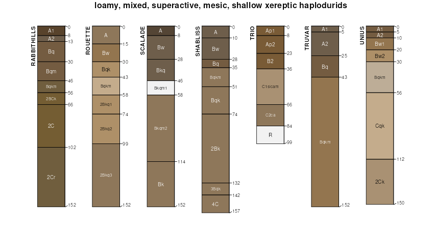
| Shabliss very fine sandy loam, 0 to 2 percent slopes | 172 | 1363 | 2519125 | 2q83 | id001 | 2012 | 1:24000 |
Shabliss very fine sandy loam, 2 to 4 percent slopes | 173 | 383 | 2519126 | 2q84 | id001 | 2012 | 1:24000 |
Shabliss silt loam, 1 to 4 percent slopes | 120 | 8930 | 80185 | 2pfm | id704 | 1992 | 1:24000 |
Shabliss silt loam, 4 to 8 percent slopes | 121 | 775 | 80186 | 2pfn | id704 | 1992 | 1:24000 |
Bioya-Puett-Shabliss association | 203 | 4061 | 2519389 | 2qj9p | nv612 | 1968 | 1:24000 |
Shabliss-Skull Creek-Puett association | 1352 | 1346 | 2519395 | 2qjp5 | nv612 | 1968 | 1:24000 |
Skull Creek-Shabliss-Puett association | 1210 | 18452 | 477038 | j0db | nv763 | 1986 | 1:24000 |
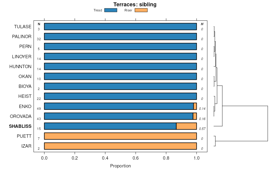
Enko-Shabliss-Orovada association | 507 | 13744 | 2633838 | 2rgmc | nv763 | 1986 | 1:24000 |
Hunnton-Shabliss-Puett association | 1223 | 10279 | 477041 | j0df | nv763 | 1986 | 1:24000 |
Weso-Orovada-Shabliss association | 613 | 5347 | 2633981 | 2rhh4 | nv763 | 1986 | 1:24000 |
Shabliss-Bartome association | 1351 | 5260 | 477061 | j0f2 | nv763 | 1986 | 1:24000 |
Shabliss-Skull Creek-Puett association | 1352 | 5205 | 477062 | j0f3 | nv763 | 1986 | 1:24000 |
Shabliss-Hunnton-Bioya association | 1350 | 4850 | 477060 | j0f1 | nv763 | 1986 | 1:24000 |
Bioya-Shabliss-Puett association | 203 | 1876 | 2633835 | 2rgm8 | nv763 | 1986 | 1:24000 |
Hunnton-Trunk-Shabliss association | 1224 | 1390 | 477042 | j0dg | nv763 | 1986 | 1:24000 |
Shabliss-Orovada-Karpp association | 1207 | 6984 | 2589850 | 2r36c | nv764 | 2021 | 1:24000 |
Shabliss-Palinor association | 480 | 37939 | 478348 | j1rl | nv766 | 1994 | 1:24000 |
Shabliss-Okan-Eastwell association | 351 | 16139 | 478302 | j1q3 | nv766 | 1994 | 1:24000 |
Palinor-Automal-Shabliss association | 854 | 12374 | 478500 | j1xh | nv766 | 1994 | 1:24000 |
Palinor-Shabliss-Linoyer association | 857 | 10554 | 478503 | j1xl | nv766 | 1994 | 1:24000 |
Shabliss-Pyrat-Okan association | 282 | 8334 | 478286 | j1pl | nv766 | 1994 | 1:24000 |
Shabliss-Okan association | 355 | 5578 | 478306 | j1q7 | nv766 | 1994 | 1:24000 |
Izar-Palinor-Shabliss association | 251 | 5531 | 478274 | j1p6 | nv766 | 1994 | 1:24000 |
Palinor-Pyrat-Shabliss association | 852 | 5404 | 478498 | j1xf | nv766 | 1994 | 1:24000 |
Eastwell-Shabliss-Izar association | 634 | 4894 | 478418 | j1tv | nv766 | 1994 | 1:24000 |
Hundraw-Shabliss-Palinor association | 244 | 4649 | 478272 | j1p4 | nv766 | 1994 | 1:24000 |
Shabliss-Tulase-Linoyer association | 700 | 4502 | 478434 | 2wbj1 | nv766 | 1994 | 1:24000 |
Shabliss-Parisa-Hunnton association | 485 | 1967 | 478353 | j1rr | nv766 | 1994 | 1:24000 |
Shabliss-Enko-Valmy association | 170 | 7062 | 475237 | hyj7 | nv769 | 1986 | 1:24000 |
Eastwell-Shabliss-Blackhawk association | 1550 | 4725 | 475228 | hyhy | nv769 | 1986 | 1:24000 |
Eastwell, moderately steep-Shabliss-Eastwell association | 1551 | 1134 | 475229 | hyhz | nv769 | 1986 | 1:24000 |
Enko-Shabliss-Orovada association | 507 | 4490 | 2633839 | 2rgmd | nv775 | 1985 | 1:24000 |
Bioya-Shabliss-Puett association | 203 | 3723 | 479514 | j2z6 | nv775 | 1985 | 1:24000 |
Bliss-Orovada-Shabliss association | 166 | 16784 | 475599 | hywx | nv777 | 1993 | 1:24000 |
Shabliss-Bliss-Genaw association | 537 | 6724 | 475781 | hz2s | nv777 | 1993 | 1:24000 |
Shabliss-Connel association | 533 | 6185 | 475777 | hz2n | nv777 | 1993 | 1:24000 |
Shabliss-Puett association | 534 | 5161 | 475778 | hz2p | nv777 | 1993 | 1:24000 |
Bliss-Shabliss association | 163 | 4353 | 475591 | hywn | nv777 | 1993 | 1:24000 |
Shabliss very fine sandy loam, 2 to 15 percent slopes | 530 | 3914 | 475774 | hz2k | nv777 | 1993 | 1:24000 |
Weso-Orovada-Shabliss association | 613 | 2866 | 475832 | hz4f | nv777 | 1993 | 1:24000 |
McConnel-Shabliss association | 333 | 2846 | 475687 | hyzr | nv777 | 1993 | 1:24000 |
Enko-Shabliss-Orovada association | 507 | 2772 | 475766 | hz29 | nv777 | 1993 | 1:24000 |
Shabliss-Enko-Dugchip association | 536 | 2582 | 475780 | hz2r | nv777 | 1993 | 1:24000 |
Enko-Shabliss complex, 2 to 8 percent slopes | 504 | 1701 | 475763 | hz26 | nv777 | 1993 | 1:24000 |
Shabliss-Enko-Valmy association | 532 | 683 | 475776 | hz2m | nv777 | 1993 | 1:24000 |
Palinor-Shabliss association | 6286 | 1069 | 2215781 | 2dcpt | nv778 | 2013 | 1:24000 |
Yody-Palinor-Shabliss association | 6573 | 203 | 2215803 | 2dcqj | nv778 | 2013 | 1:24000 |
Parisa-Palinor-Shabliss association | 6334 | 69 | 2215790 | 2dcq3 | nv778 | 2013 | 1:24000 |
Yody-Shabliss association | 1330 | 34 | 2215632 | 2dck0 | nv778 | 2013 | 1:24000 |
Shabliss-Tulase-Linoyer association | 6455 | 8 | 2215797 | 2dcqb | nv778 | 2013 | 1:24000 |
Shabliss-Palinor association | 1060 | 10301 | 479928 | j3dk | nv779 | 2004 | 1:24000 |
Eastwell-Shabliss association | 3301 | 9283 | 480053 | j3jl | nv779 | 2004 | 1:24000 |
Eastwell-Shabliss-Izar association | 3300 | 7293 | 480052 | j3jk | nv779 | 2004 | 1:24000 |
Automal-Shabliss association | 3142 | 2260 | 480010 | j3h6 | nv779 | 2004 | 1:24000 |
Palinor-Shabliss association | 1052 | 1306 | 636698 | pcjn | nv779 | 2004 | 1:24000 |
Linoyer-Tulase-Shabliss association | 3177 | 1055 | 480014 | j3hb | nv779 | 2004 | 1:24000 |
Palinor-Shabliss association | 286 | 79203 | 480400 | j3ws | nv780 | 1990 | 1:24000 |
Palinor-Shabliss-Tulase association | 290 | 29348 | 480404 | j3wx | nv780 | 1990 | 1:24000 |
Shabliss-Yody association | 450 | 21317 | 480482 | j3zf | nv780 | 1990 | 1:24000 |
Shabliss-Tulase-Linoyer association | 455 | 19179 | 480487 | 2wbj1 | nv780 | 1990 | 1:24000 |
Parisa-Palinor-Shabliss association | 334 | 17890 | 480430 | j3xr | nv780 | 1990 | 1:24000 |
Shabliss-Pyrat association | 1141 | 17050 | 480171 | j3nd | nv780 | 1990 | 1:24000 |
Abgese-Yody-Shabliss association | 920 | 11990 | 480638 | j44g | nv780 | 1990 | 1:24000 |
Shabliss-Pyrat-Palinor association | 458 | 10659 | 480490 | j3zp | nv780 | 1990 | 1:24000 |
Yody-Palinor-Shabliss association | 573 | 5244 | 480533 | j412 | nv780 | 1990 | 1:24000 |
Yody-Shabliss association | 1330 | 4747 | 480238 | j3qk | nv780 | 1990 | 1:24000 |
Pyrat-Shabliss-Linoyer association | 1492 | 3826 | 480278 | j3rv | nv780 | 1990 | 1:24000 |
Shabliss-Orovada-Karpp association | 1207 | 339 | 2928251 | 2w2tc | nv780 | 1990 | 1:24000 |
Dewar-Shabliss-Alley association | 2361 | 18859 | 480881 | j4d9 | nv781 | 1994 | 1:24000 |
Dewar-Shabliss-Alley association | 8115 | 8216 | 3423208 | 312v5 | nv781 | 1994 | 1:24000 |
Dewar-Shabliss-Alley association | 8115 | 3892 | 3423005 | 312v5 | nv782 | 2025 | 1:24000 |
Shabliss very fine sandy loam, 2 to 5 percent slopes | SfC | 24039 | 482613 | j665 | ut608 | 1981 | 1:24000 |
Shabliss very fine sandy loam, moist, 2 to 5 percent slopes | SgC | 2982 | 482616 | j668 | ut608 | 1981 | 1:24000 |
Shabliss very fine sandy loam, 15 to 30 percent slopes | SfE | 2583 | 482615 | j667 | ut608 | 1981 | 1:24000 |
Shabliss very fine sandy loam, 5 to 15 percent slopes | SfD | 1031 | 482614 | j666 | ut608 | 1981 | 1:24000 |