| Sequoia silty clay, severely eroded, rolling | Sc | 1000 | 329212 | c1kr | al049 | 1953 | 1:20000 |
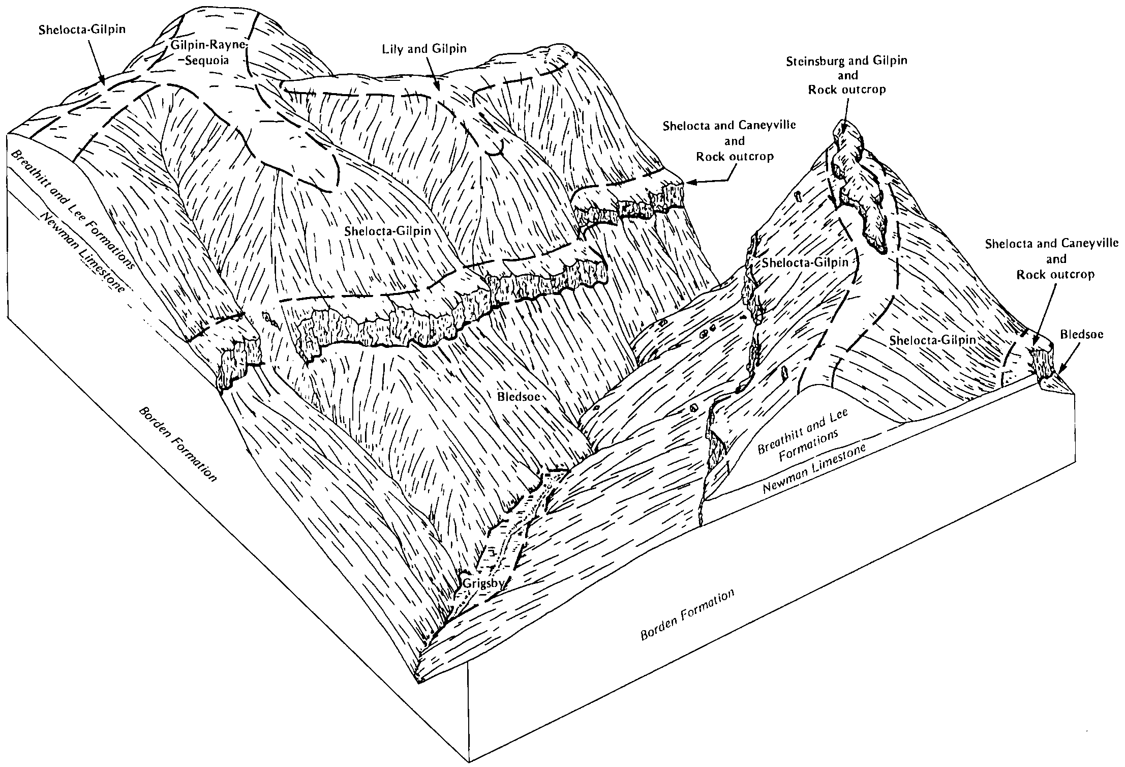
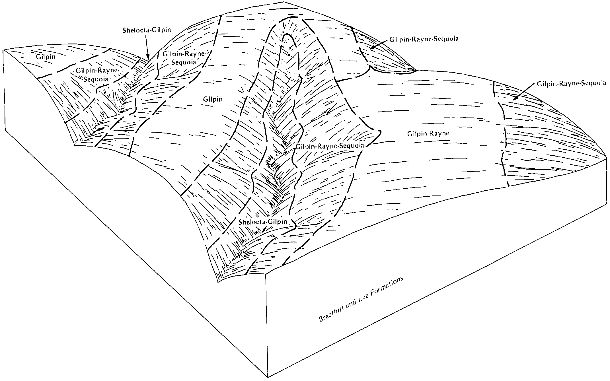
Gilpin-Rayne-Sequoia complex, 25 to 55 percent slopes, very stony | GsF | 69185 | 552525 | 2tqhj | ky051 | 1994 | 1:24000 |
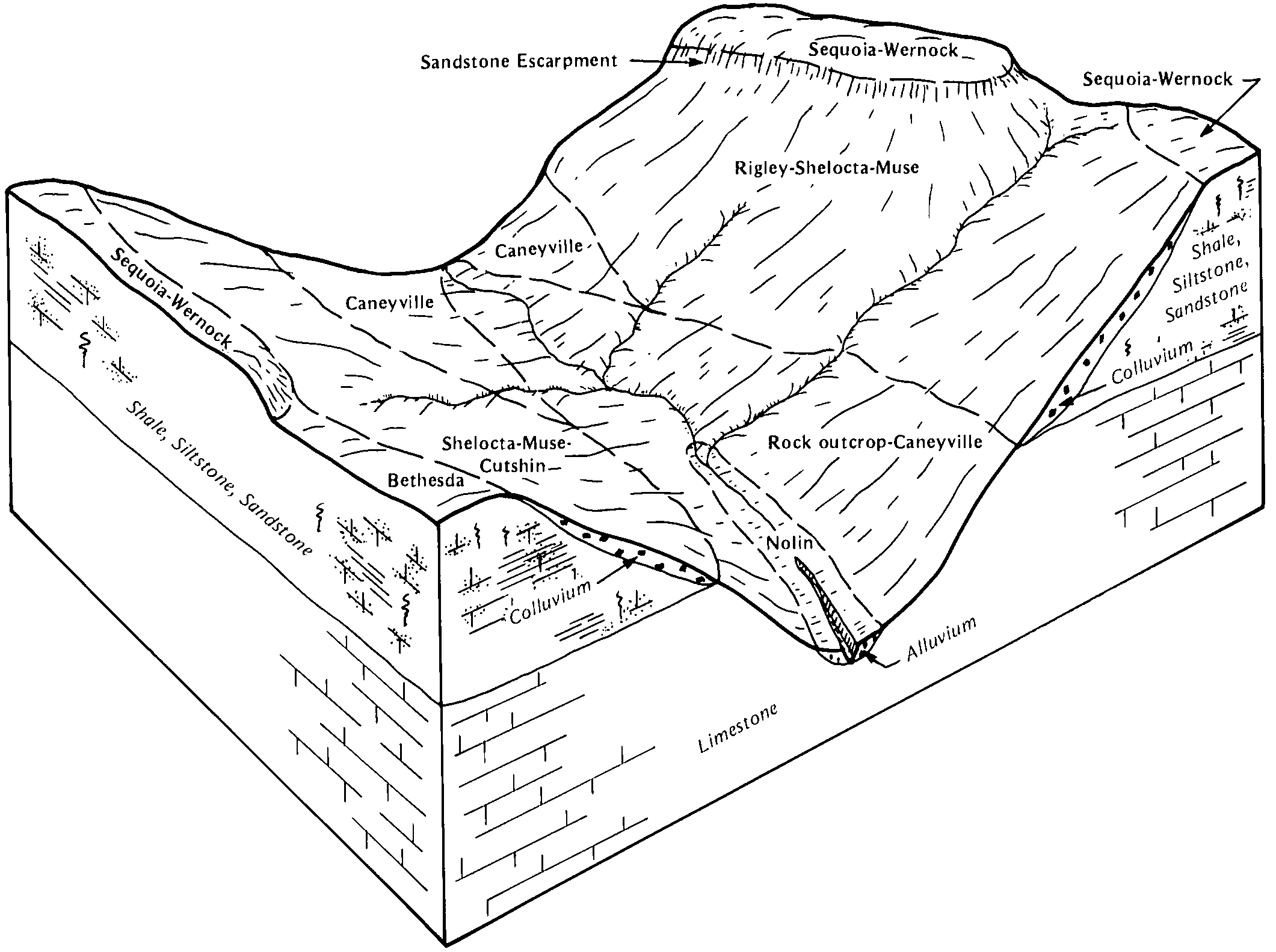
Sequoia-Wernock silt loams, 6 to 20 percent slopes | SeD | 1329 | 551428 | lht0 | ky053 | 1990 | 1:20000 |
Sequoia silty clay loam, 15 to 30 percent slopes | uSeqE | 405 | 2517265 | 2q97v | ky053 | 1990 | 1:20000 |
Sequoia-Wernock silt loams, 6 to 20 percent slopes | SeD | 10832 | 550087 | lgdr | ky231 | 1985 | 1:20000 |
Sequoia silty clay loam, 15 to 30 percent slopes | uSeqE | 393 | 2517263 | 2q97v | ky231 | 1985 | 1:20000 |
Gilpin-Rayne-Sequoia complex, 12 to 25 percent slopes | GrD | 3220 | 557765 | lqdf | ky616 | 2004 | 1:24000 |
Gilpin-Rayne-Sequoia silt loams, 12 to 25 percent slopes | GrD | 18782 | 550706 | lh1q | ky623 | 1985 | 1:20000 |
Shelocta-Highsplint-Sequoia complex, 30 to 80 percent slopes, rocky | 11F | 101156 | 612216 | nk1x | ky630 | 1966 | 1:15840 |
Shelocta-Sequoia complex, 20 to 35 percent slopes, rocky | 22E | 65656 | 609622 | ngc7 | ky630 | 1966 | 1:15840 |
Wernock-Sequoia complex, 12 to 25 percent slopes | 3D | 46466 | 609545 | ng8r | ky630 | 1966 | 1:15840 |
Sequoia-Wernock complex, 6 to 12 percent slopes | 4C | 14785 | 609547 | ng8t | ky630 | 1966 | 1:15840 |
Wernock-Gilpin-Sequoia complex, 12 to 40 percent slopes, rocky | 3E | 3918 | 746039 | t19s | ky630 | 1966 | 1:15840 |
Sequoia silt loam, 6 to 12 percent slopes | 7C | 300 | 609549 | ng8w | ky630 | 1966 | 1:15840 |
Gilpin-Rayne-Sequoia complex, 25 to 55 percent slopes, very stony | GtF | 49825 | 552119 | 2tqhj | ky638 | 1989 | 1:24000 |
Sequoia silty clay loam, eroded rolling phase | Se | 8538 | 526976 | kpc7 | tn011 | 1951 | 1:20000 |
Sequoia silty clay loam, eroded undulating phase | Sf | 5503 | 526977 | kpc8 | tn011 | 1951 | 1:20000 |
Sequoia silty clay, severely eroded rolling phase | Sd | 3519 | 526975 | kpc6 | tn011 | 1951 | 1:20000 |
Sequoia silt loam, rolling phase | Sb | 451 | 526973 | kpc4 | tn011 | 1951 | 1:20000 |
Sequoia silt loam, undulating phase | Sc | 259 | 526974 | kpc5 | tn011 | 1951 | 1:20000 |
Muskingum-Sequoia-Petros complex, 30 to 60 percent slopes | MkF | 93306 | 524269 | kljx | tn013 | 1993 | 1:24000 |
Sequoia silt loam, 5 to 12 percent slopes, eroded | SeC2 | 2914 | 524275 | klk3 | tn013 | 1993 | 1:24000 |
Sequoia silty clay loam, 15 to 25 percent slopes, severely eroded | SeD3 | 1624 | 524278 | klk6 | tn013 | 1993 | 1:24000 |
Sequoia silty clay loam, 5 to 15 percent slopes, severely eroded | SeC3 | 1099 | 524276 | klk4 | tn013 | 1993 | 1:24000 |
Sequoia silt loam, 25 to 45 percent slopes, eroded | SeE2 | 616 | 524279 | klk7 | tn013 | 1993 | 1:24000 |
Sequoia silt loam, 12 to 25 percent slopes, eroded | SeD2 | 529 | 524277 | klk5 | tn013 | 1993 | 1:24000 |
Sequoia silty clay loam, eroded phase | Ssr | 317 | 524552 | klv1 | tn025 | 1948 | 1:24000 |
Sequoia silty clay loam, rolling, 5 to 12 percent slope | 75C | 1103 | 525337 | kmnc | tn063 | 2007 | 1:24000 |
Sequoia silty clay loam, hilly, 12 to 25 percent slope | 75D | 481 | 525339 | kmnf | tn063 | 2007 | 1:24000 |
Sequoia silty clay loam, severely eroded, hilly, 12 to 25 percent slopes | 75D3 | 19 | 525340 | kmng | tn063 | 2007 | 1:24000 |
Sequoia silt loam, 8 to 20 percent slopes | SmD | 323 | 1017883 | 1355y | tn065 | 1980 | 1:15840 |
Sequoia silt loam, 5 to 12 percent slopes, eroded | SeC2 | 2899 | 525501 | kmtn | tn089 | 1991 | 1:24000 |
Sequoia silt loam, 12 to 20 percent slopes, eroded | SeD2 | 2029 | 525503 | kmtq | tn089 | 1991 | 1:24000 |
Sequoia silty clay loam, 5 to 12 percent slopes, severely eroded | SeC3 | 662 | 525502 | kmtp | tn089 | 1991 | 1:24000 |
Sequoia silt loam, 2 to 5 percent slopes, eroded | SeB2 | 313 | 525500 | kmtm | tn089 | 1991 | 1:24000 |
Sequoia silty clay loam, eroded sloping phase | SkC2 | 1943 | 525998 | knbp | tn105 | 1958 | 1:15840 |
Sequoia silty clay, severely eroded sloping phase | SlC3 | 1223 | 526000 | knbr | tn105 | 1958 | 1:15840 |
Sequoia silty clay loam, eroded gently sloping phase | SkB2 | 1061 | 525997 | knbn | tn105 | 1958 | 1:15840 |
Sequoia silty clay, severely eroded moderately steep phase | SlD3 | 480 | 526001 | knbs | tn105 | 1958 | 1:15840 |
Sequoia silty clay loam, eroded moderately steep phase | SkD2 | 303 | 525999 | knbq | tn105 | 1958 | 1:15840 |
Sequoia silt loam, sloping phase | SeC | 258 | 525996 | knbm | tn105 | 1958 | 1:15840 |
Sequoia silt loam, 5 to 12 percent slopes, eroded | SeC2 | 3678 | 527928 | kqby | tn123 | 1974 | 1:20000 |
Sequoia silt loam, 2 to 5 percent slopes | SeB | 2648 | 527927 | kqbx | tn123 | 1974 | 1:20000 |
Sequoia silty clay, 5 to 12 percent slopes, severely eroded | SgC3 | 2288 | 527930 | kqc0 | tn123 | 1974 | 1:20000 |
Litz and Sequoia soils, gullied | LY | 1375 | 527913 | kqbg | tn123 | 1974 | 1:20000 |
Sequoia silt loam, 12 to 20 percent slopes, eroded | SeD2 | 1085 | 527929 | kqbz | tn123 | 1974 | 1:20000 |
Sequoia silty clay, 12 to 20 percent slopes, severely eroded | SgD3 | 1082 | 527931 | kqc1 | tn123 | 1974 | 1:20000 |
Sequoia silty clay loam, 15 to 30 percent slopes | uSeqE | 2428 | 2517266 | 2q97v | tn133 | 2003 | 1:24000 |
Sequoia-Gilpin complex, 20 to 35 percent slopes | SgE | 734 | 728878 | sgg6 | tn143 | 2003 | 1:24000 |
Sequoia silt loam, 20 to 35 percent slopes | SeE | 407 | 528420 | kqvt | tn171 | 1980 | 1:24000 |
Sequoia silt loam, 10 to 20 percent slopes | SeD | 375 | 528419 | kqvs | tn171 | 1980 | 1:24000 |
Sequoia silty clay loam, eroded rolling phase | Sse | 1568 | 529999 | kshr | tn173 | 1945 | 1:24000 |
Sequoia silt loam, undulating phase | Sqn | 333 | 529997 | kshp | tn173 | 1945 | 1:24000 |
Sequoia silt loam, 3 to 12 percent slopes, eroded | SkC2 | 3058 | 528604 | kr1r | tn602 | 1973 | 1:15840 |
Sequoia silt loam, 12 to 20 percent slopes, eroded | SkD2 | 2695 | 528605 | kr1s | tn602 | 1973 | 1:15840 |
Sequoia silty clay loam, 15 to 30 percent slopes | uSeqE | 852 | 2517262 | 2q97v | tn604 | 1974 | 1:20000 |
Sequoia silt loam, 12 to 20 percent slopes | SeD | 1030 | 530683 | kt6t | tn607 | 2003 | 1:24000 |
Sequoia silt loam, 5 to 12 percent slopes | SeC | 577 | 530699 | kt7b | tn607 | 2003 | 1:24000 |
Sequoia silt loam, 2 to 5 percent slopes | SeB | 99 | 530690 | kt71 | tn607 | 2003 | 1:24000 |
Sequoia silty clay loam, eroded sloping phase | Sg | 6896 | 1899556 | 21rn0 | tn609 | 1955 | 1:20000 |
Sequoia silty clay loam, eroded gently sloping phase | Sf | 3695 | 1899555 | 21rmz | tn609 | 1955 | 1:20000 |
Sequoia silty clay, severely eroded sloping phase | Se | 2143 | 1899554 | 21rmy | tn609 | 1955 | 1:20000 |
Sequoia silty clay loam, 15 to 30 percent slopes | uSeqE | 1686 | 2517261 | 2q97v | tn610 | 1960 | 1:15840 |
Wellston silt loam, 5 to 12 percent slopes | WeC | 362 | 2427516 | 2mh0z | tn610 | 1960 | 1:15840 |
Wellston silt loam, 5 to 12 percent slopes, eroded | WeC2 | 310 | 2427517 | 2mh10 | tn610 | 1960 | 1:15840 |
Wellston silt loam, 2 to 5 percent slopes | WeB | 233 | 2427515 | 2mh0y | tn610 | 1960 | 1:15840 |
Sequoia silt loam, 12 to 20 percent slopes | SeD | 823 | 2439113 | 2mw32 | tn629 | 2003 | 1:24000 |
Sequoia silt loam, 5 to 12 percent slopes | SeC | 474 | 2439112 | 2mw31 | tn629 | 2003 | 1:24000 |
Gilpin-Sequoia complex, 5 to 12 percent slopes | GsC | 1150 | 1910102 | 223m6 | tn650 | 2008 | 1:12000 |
Gilpin-Sequoia complex, 12 to 20 percent slopes | GsD | 1048 | 2406064 | 2lrpz | tn650 | 2008 | 1:12000 |
Gilpin-Sequoia complex, 2 to 5 percent slopes | GsB | 129 | 2232677 | 2dy8v | tn650 | 2008 | 1:12000 |
Shelocta-Sequoia-Petros complex, 10 to 35 percent slopes | SlE | 4810 | 2439181 | 2mw58 | tn701 | 1985 | 1:24000 |
Sequoia silt loam, 5 to 20 percent slopes, eroded | SaD2 | 3209 | 2439179 | 2mw56 | tn701 | 1985 | 1:24000 |
Sequoia silty clay loam, 15 to 30 percent slopes | uSeqE | 936 | 2517264 | 2q97v | tn701 | 1985 | 1:24000 |
Sequoia-Berks silt loams, 7 to 15 percent slopes, eroded | 74C2 | 3175 | 518039 | kd1y | va015 | 1978 | 1:15840 |
Sequoia-Berks silt loams, 2 to 7 percent slopes, eroded | 74B2 | 2868 | 518038 | kd1x | va015 | 1978 | 1:15840 |
Sequoia silt loam, 2 to 7 percent slopes, eroded | 73B2 | 1715 | 518036 | kd1v | va015 | 1978 | 1:15840 |
Sequoia-Berks silt loams, 15 to 25 percent slopes, eroded | 74D2 | 638 | 518040 | kd1z | va015 | 1978 | 1:15840 |
Sequoia silt loam, 7 to 15 percent slopes, eroded | 73C2 | 581 | 518037 | kd1w | va015 | 1978 | 1:15840 |
Sequoia loam, 7 to 15 percent slopes | 27C | 3440 | 135962 | 4kgw | va019 | 1985 | 1:24000 |
Sequoia loam, 15 to 25 percent slopes | 27D | 2778 | 135963 | 4kgx | va019 | 1985 | 1:24000 |
Sequoia silt loam, 7 to 15 percent slopes | 38C | 839 | 521114 | kh84 | va069 | 1983 | 1:15840 |
Sequoia silt loam, 2 to 7 percent slopes | 38B | 474 | 521113 | kh83 | va069 | 1983 | 1:15840 |
Sequoia silt loam, 15 to 25 percent slopes | 38D | 323 | 521115 | kh85 | va069 | 1983 | 1:15840 |
Sequoia silt loam, 30 to 65 percent slopes | 33F | 671 | 516699 | kbnq | va071 | 1981 | 1:15840 |
Sequoia silt loam, 10 to 30 percent slopes | 33D | 331 | 516698 | kbnp | va071 | 1981 | 1:15840 |
Sequoia silt loam, 7 to 15 percent slopes | 37C | 1059 | 520291 | kgdl | va161 | 1990 | 1:24000 |
Sequoia silt loam, 15 to 25 percent slopes | 37D | 742 | 520292 | kgdm | va161 | 1990 | 1:24000 |
Sequoia silt loam, 25 to 40 percent slopes | 37E | 641 | 520293 | kgdn | va161 | 1990 | 1:24000 |
Sequoia silt loam, 2 to 7 percent slopes | 37B | 146 | 520290 | kgdk | va161 | 1990 | 1:24000 |
Sequoia-Berks silt loams, 7 to 15 percent slopes, eroded | 59C2 | 4200 | 518444 | kdh0 | va165 | 1980 | 1:20000 |
Sequoia-Berks loams, 15 to 25 percent slopes, stony | 60D | 2845 | 518449 | kdh5 | va165 | 1980 | 1:20000 |
Sequoia-Berks silt loams, 2 to 7 percent slopes, eroded | 59B2 | 2182 | 518443 | kdgz | va165 | 1980 | 1:20000 |
Sequoia-Berks loams, 7 to 15 percent slopes, stony | 60C | 1648 | 518448 | kdh4 | va165 | 1980 | 1:20000 |
Sequoia silt loam, 2 to 7 percent slopes, eroded | 58B2 | 1204 | 518441 | kdgx | va165 | 1980 | 1:20000 |
Sequoia-Berks silt loams, 15 to 25 percent slopes, eroded | 59D2 | 1138 | 518445 | kdh1 | va165 | 1980 | 1:20000 |
Sequoia silt loam, 7 to 15 percent slopes, eroded | 58C2 | 443 | 518442 | kdgy | va165 | 1980 | 1:20000 |
Sequoia loam, 15 to 35 percent slopes | 53D | 1724 | 520784 | kgxh | va171 | 1988 | 1:15840 |
Sequoia loam, 2 to 15 percent slopes | 53C | 902 | 520783 | kgxg | va171 | 1988 | 1:15840 |
Sequoia loam, 35 to 55 percent slopes | 53E | 120 | 520785 | kgxj | va171 | 1988 | 1:15840 |
Sequoia silt loam, 2 to 7 percent slopes | 38B | 1342 | 518853 | kdx6 | va187 | 1980 | 1:15840 |
Sequoia silt loam, 7 to 15 percent slopes | 38C | 973 | 518854 | kdx7 | va187 | 1980 | 1:15840 |

