| Sensabaugh gravelly loam, 0 to 4 percent slopes, occasionally flooded | Se | 3720 | 551472 | lhvf | ky057 | 1991 | 1:20000 |
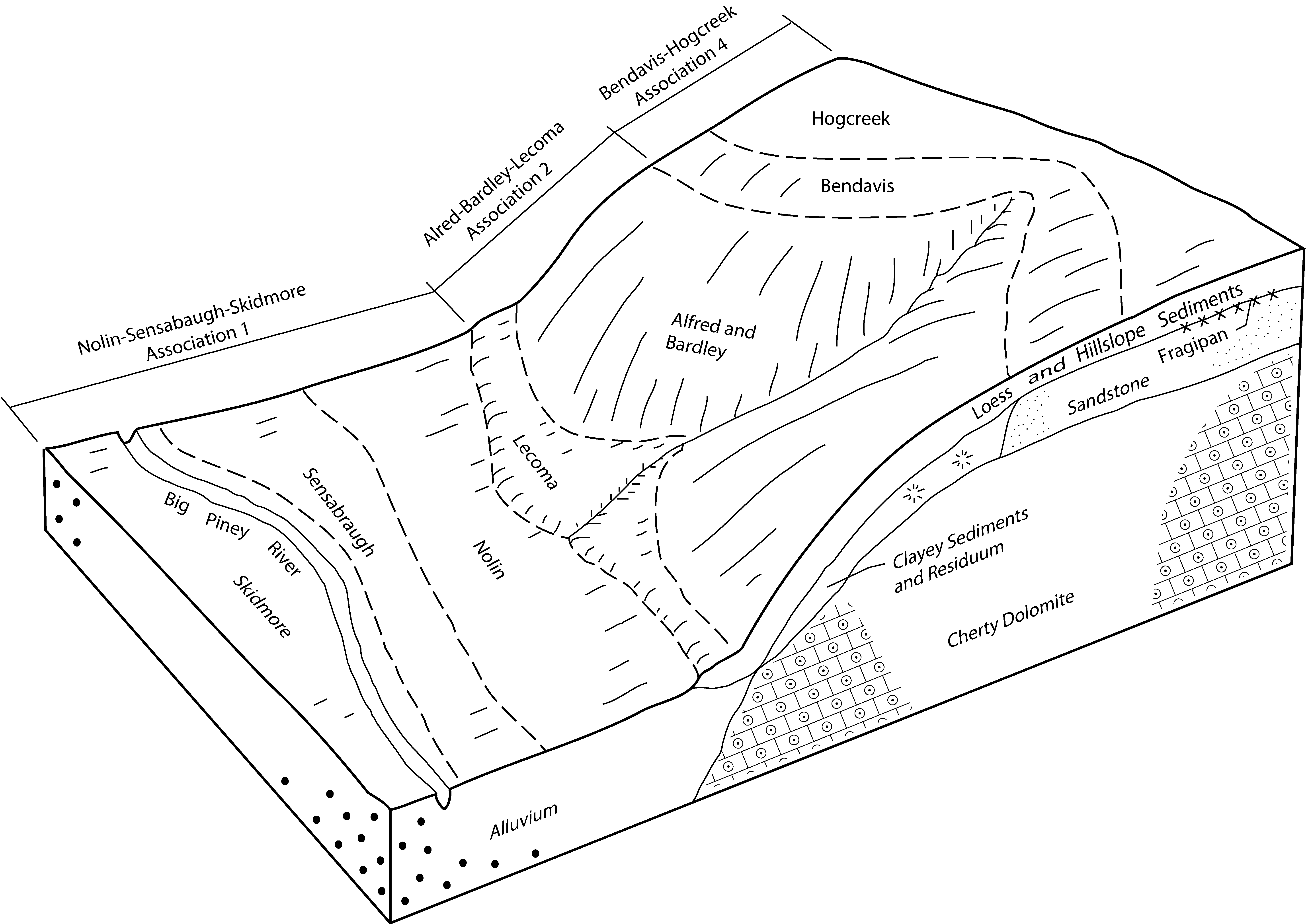
Sensabaugh gravelly loam, 2 to 6 percent slopes | SgB | 1670 | 551473 | lhvg | ky057 | 1991 | 1:20000 |
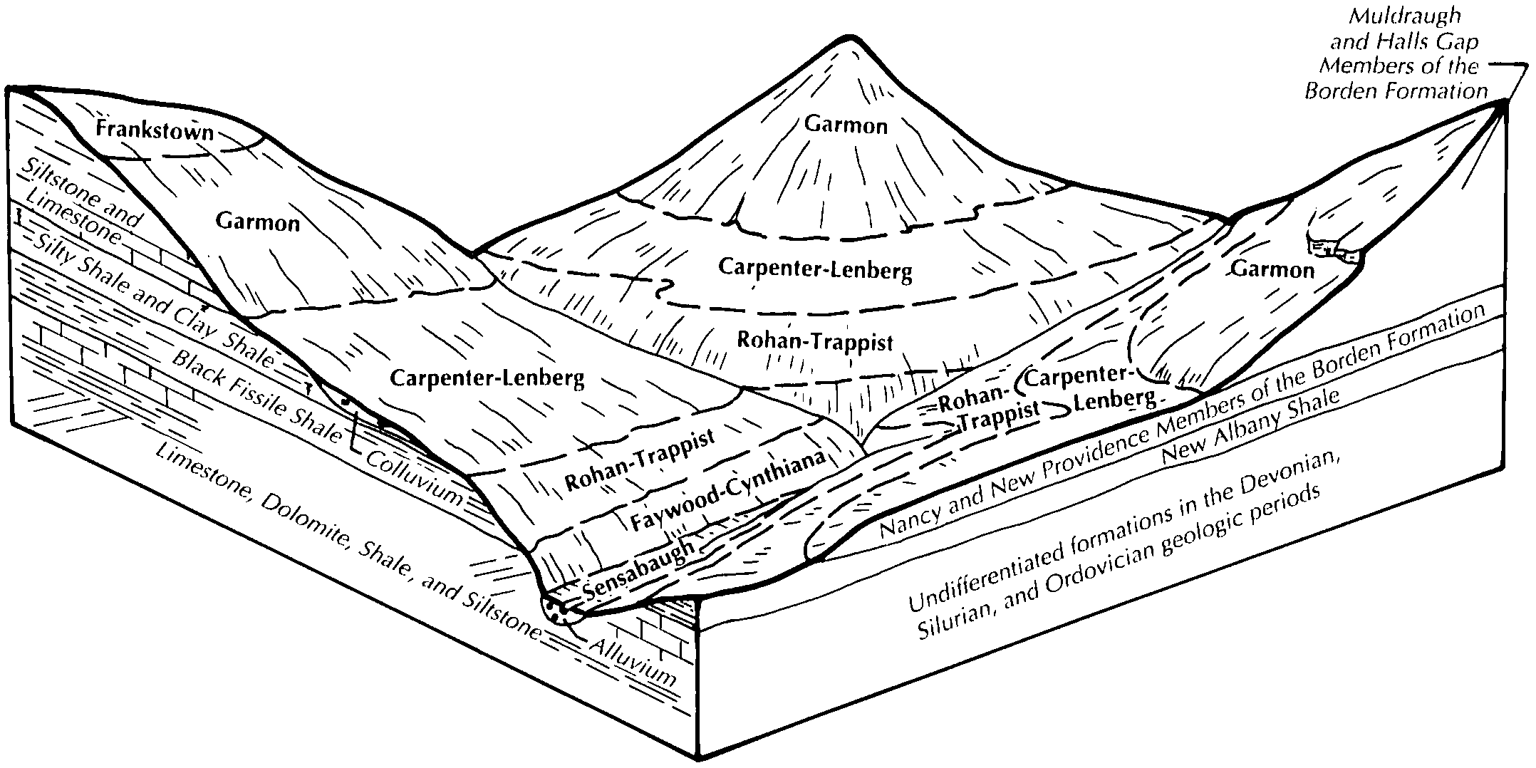
Sensabaugh gravelly silt loam, frequently flooded | Se | 2125 | 552370 | ljsd | ky155 | 1986 | 1:20000 |
Huntington gravelly silt loam (sensabaugh) | Hg | 2989 | 549767 | lg2f | ky169 | 1965 | 1:15840 |
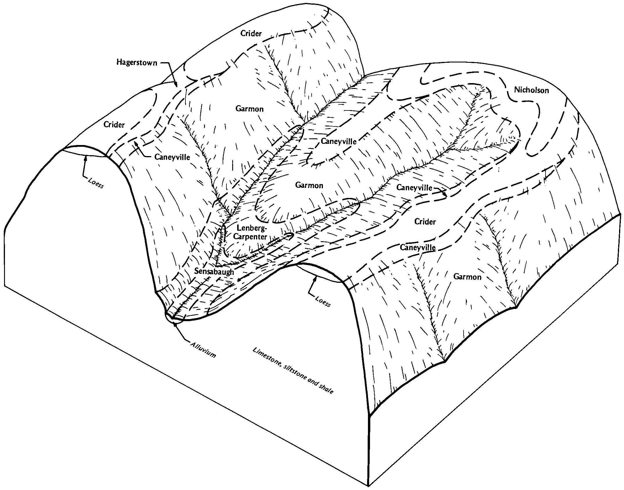
Sensabaugh gravelly silt loam | Se | 2790 | 549914 | lg75 | ky171 | 1977 | 1:20000 |
Huntington silt loam, gravelly variant (sensabaugh) | Hv | 1150 | 549970 | lg8z | ky179 | 1967 | 1:15840 |
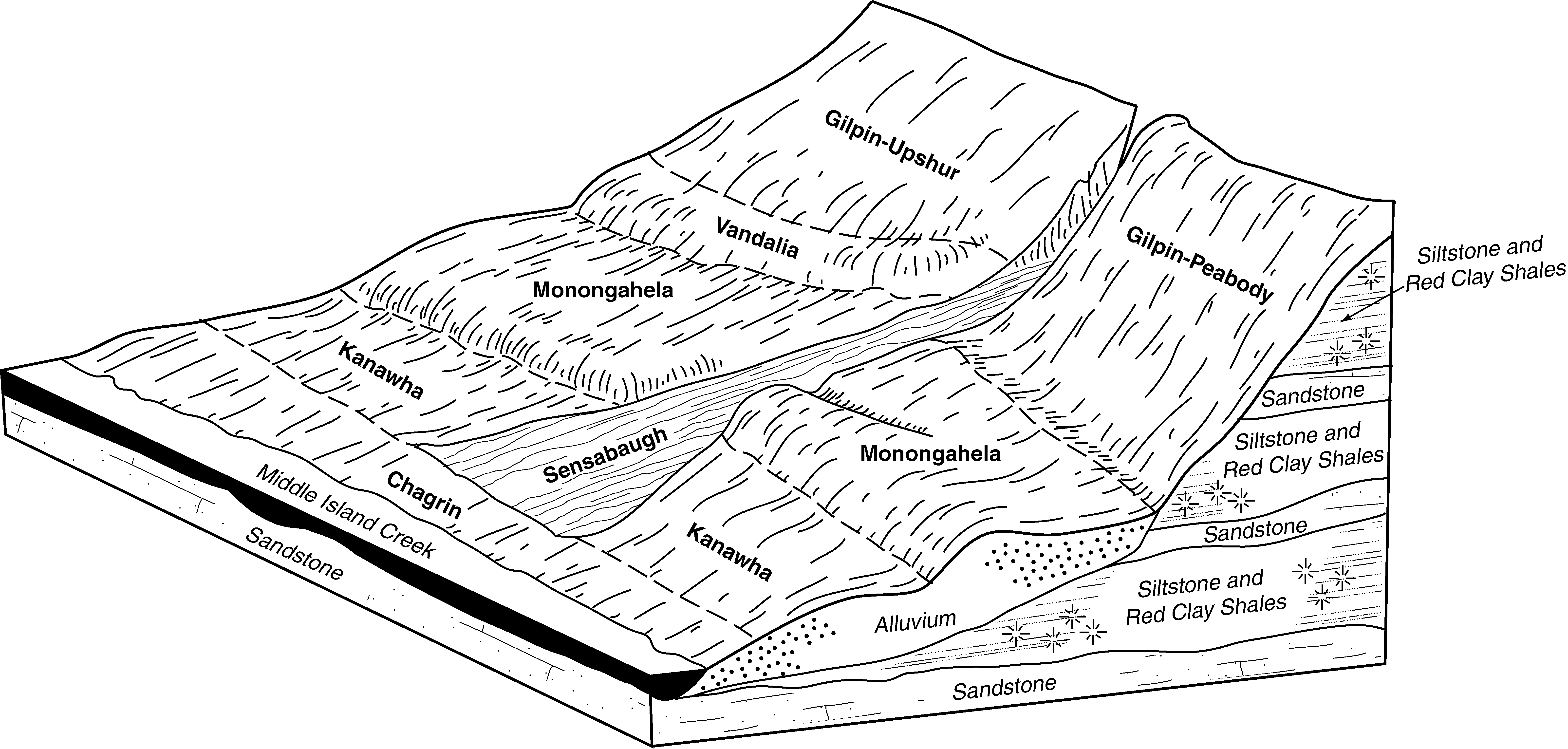
Chagrin gravelly silty clay loam (sensabaugh 0 to 4 percent slopes, occasionally flooded) | Cg | 1045 | 552025 | ljf8 | ky603 | 1968 | 1:15840 |
Sensabaugh gravelly silt loam | Se | 1534 | 551561 | lhy9 | ky606 | 1979 | 1:20000 |
Sensabaugh gravelly loam, occasionally flooded | Sg | 4304 | 551014 | lhcn | ky608 | 1983 | 1:20000 |
Sensabaugh gravelly silt loam | Se | 1940 | 552577 | lk02 | ky620 | 1979 | 1:20000 |
Sensabaugh silt loam | Sg | 4165 | 551072 | lhfj | ky621 | 1975 | 1:20000 |
Robinsonville gravelly silt loam (sensabaugh) | Rg | 5043 | 2453005 | 2nbk6 | ky646 | 1966 | 1:15840 |
Sensabaugh silt loam, 1 to 3 percent slopes, frequently flooded | 67075 | 2122 | 2575462 | 2r0cm | mo183 | 1979 | 1:24000 |
Sensabaugh silt loam, 0 to 2 percent slopes, frequently flooded | 67555 | 1859 | 2575475 | 2r0cy | mo183 | 1979 | 1:24000 |
Sensabaugh silt loam, 0 to 2 percent slopes, occasionally flooded | 66105 | 274 | 2533777 | 2qp9v | mo183 | 1979 | 1:24000 |
Sensabaugh silt loam, 0 to 2 percent slopes, frequently flooded | 67555 | 62 | 2575476 | 2r0cy | mo219 | 1975 | 1:24000 |
Sensabaugh gravelly loam, 2 to 12 percent slopes | SnC | 218 | 525069 | 2zvlx | tn059 | 1954 | 1:15840 |
Sensabaugh loam | Sb | 1013 | 528418 | kqvr | tn171 | 1980 | 1:24000 |
Sensabaugh gravelly loam | Sa | 4015 | 528602 | kr1p | tn602 | 1973 | 1:15840 |
Sensabaugh-Lobdell-Derroc complex, 0 to 3 percent slopes, occasionally flooded | 57A | 2121 | 2514843 | 2qdcn | va163 | 2010 | 1:24000 |
Sensabaugh-Lobdell loams, 2 to 8 percent slopes | SeB | 4705 | 514868 | k8rn | wv005 | 1988 | 1:24000 |
Sensabaugh silt loam, 3 to 8 percent slopes, rarely flooded | SrB | 3410 | 513068 | 2w1w4 | wv007 | 1990 | 1:24000 |
Sensabaugh silt loam, 0 to 3 percent slopes, occasionally flooded | SoA | 3190 | 513067 | 2w1w3 | wv007 | 1990 | 1:24000 |
Sensabaugh-Vandalia-Urban land complex, 3 to 15 percent slopes | SvC | 3340 | 513680 | k7jb | wv011 | 1984 | 1:20000 |
Sensabaugh loam, 0 to 3 percent slopes, occasionally flooded | SoA | 3250 | 513678 | 2w1w5 | wv011 | 1984 | 1:20000 |
Sensabaugh loam, 3 to 8 percent slopes, rarely flooded | SrB | 2800 | 513679 | 2w1w6 | wv011 | 1984 | 1:20000 |
Sensabaugh silt loam, 0 to 3 percent slopes, occasionally flooded | Ss | 2014 | 516108 | 2w1w3 | wv015 | 1998 | 1:24000 |
Sensabaugh silt loam, 0 to 3 percent slopes, occasionally flooded | Se | 6888 | 561744 | 2w1w3 | wv017 | 2001 | 1:24000 |
Sensabaugh silt loam, 3 to 8 percent slopes, rarely flooded | SeB | 5657 | 561752 | 2w1w4 | wv017 | 2001 | 1:24000 |
Sensabaugh-Urban land complex | Su | 219 | 553397 | lkvj | wv017 | 2001 | 1:24000 |
Sensabaugh-Urban land complex, 3 to 8 percent slopes, rarely flooded | SuB | 72 | 561753 | lvk2 | wv017 | 2001 | 1:24000 |
Sensabaugh loam, 0 to 3 percent slopes, occasionally flooded | Sb | 10051 | 514912 | 2w1w5 | wv021 | 1995 | 1:24000 |
Sensabaugh loam | Se | 1282 | 553074 | lkj3 | wv025 | 2002 | 1:24000 |
Sensabaugh silt loam, 0 to 3 percent slopes, occasionally flooded | Sn | 6049 | 512861 | 2w1w3 | wv039 | 1976 | 1:20000 |
Sensabaugh silt loam, 0 to 3 percent slopes, occasionally flooded | Su | 3463 | 514820 | 2w1w3 | wv041 | 1989 | 1:20000 |
Sensabaugh loam, 3 to 8 percent slopes, rarely flooded | SfB | 2310 | 553330 | 2w1w6 | wv043 | 2005 | 1:24000 |
Sensabaugh loam, 0 to 3 percent slopes, occasionally flooded | SeA | 518 | 553329 | 2w1w5 | wv043 | 2005 | 1:24000 |
Sensabaugh silt loam, 3 to 8 percent slopes, rarely flooded | SfB | 1980 | 749358 | 2w1w4 | wv051 | 2007 | 1:12000 |
Sensabaugh silt loam, 0 to 3 percent slopes, occasionally flooded | SeA | 1650 | 749357 | 2w1w3 | wv051 | 2007 | 1:12000 |
Sensabaugh-Urban land complex, 3 to 8 percent slopes, rarely flooded | ShB | 243 | 749355 | t4rr | wv051 | 2007 | 1:12000 |
Sensabaugh-Urban land complex, 0 to 3 percent slopes, occasionally flooded | SgA | 111 | 749351 | t4rm | wv051 | 2007 | 1:12000 |
Sensabaugh silt loam | Se | 2760 | 515438 | k9c1 | wv075 | 1992 | 1:24000 |
Sensabaugh silt loam, 0 to 3 percent slopes, occasionally flooded | Sn | 5702 | 513184 | 2w1w3 | wv079 | 1981 | 1:20000 |
Sensabaugh silt loam, 3 to 8 percent slopes, rarely flooded | SrB | 1553 | 513185 | 2w1w4 | wv079 | 1981 | 1:20000 |
Sensabaugh silt loam, 0 to 3 percent slopes, occasionally flooded | Sn | 11071 | 513299 | 2w1w3 | wv085 | 1980 | 1:20000 |
Sensabaugh loam, 0 to 3 percent slopes, occasionally flooded | SnA | 15494 | 1384146 | 2w1w5 | wv600 | 2005 | 1:24000 |
Sensabaugh loam, 3 to 8 percent slopes, rarely flooded | SrB | 4793 | 1384209 | 2w1w6 | wv600 | 2005 | 1:24000 |
Sensabaugh loam, 0 to 3 percent slopes, occasionally flooded | Ss | 4972 | 514626 | 2w1w5 | wv601 | 1966 | 1:15840 |
Sensabaugh silt loam, 0 to 3 percent slopes, occasionally flooded | Sn | 12871 | 514710 | 2w1w3 | wv612 | 1984 | 1:20000 |
Sensabaugh-Lobdell loams, 2 to 8 percent slopes | SeB | 4985 | 1155560 | 17sg4 | wv620 | 2005 | 1:24000 |
Sensabaugh loam, 3 to 8 percent slopes | SbB | 10 | 1155559 | 17sg3 | wv620 | 2005 | 1:24000 |
Sensabaugh silt loam, 0 to 3 percent slopes, occasionally flooded | Ss | 17995 | 515194 | 2w1w3 | wv624 | 1993 | 1:24000 |