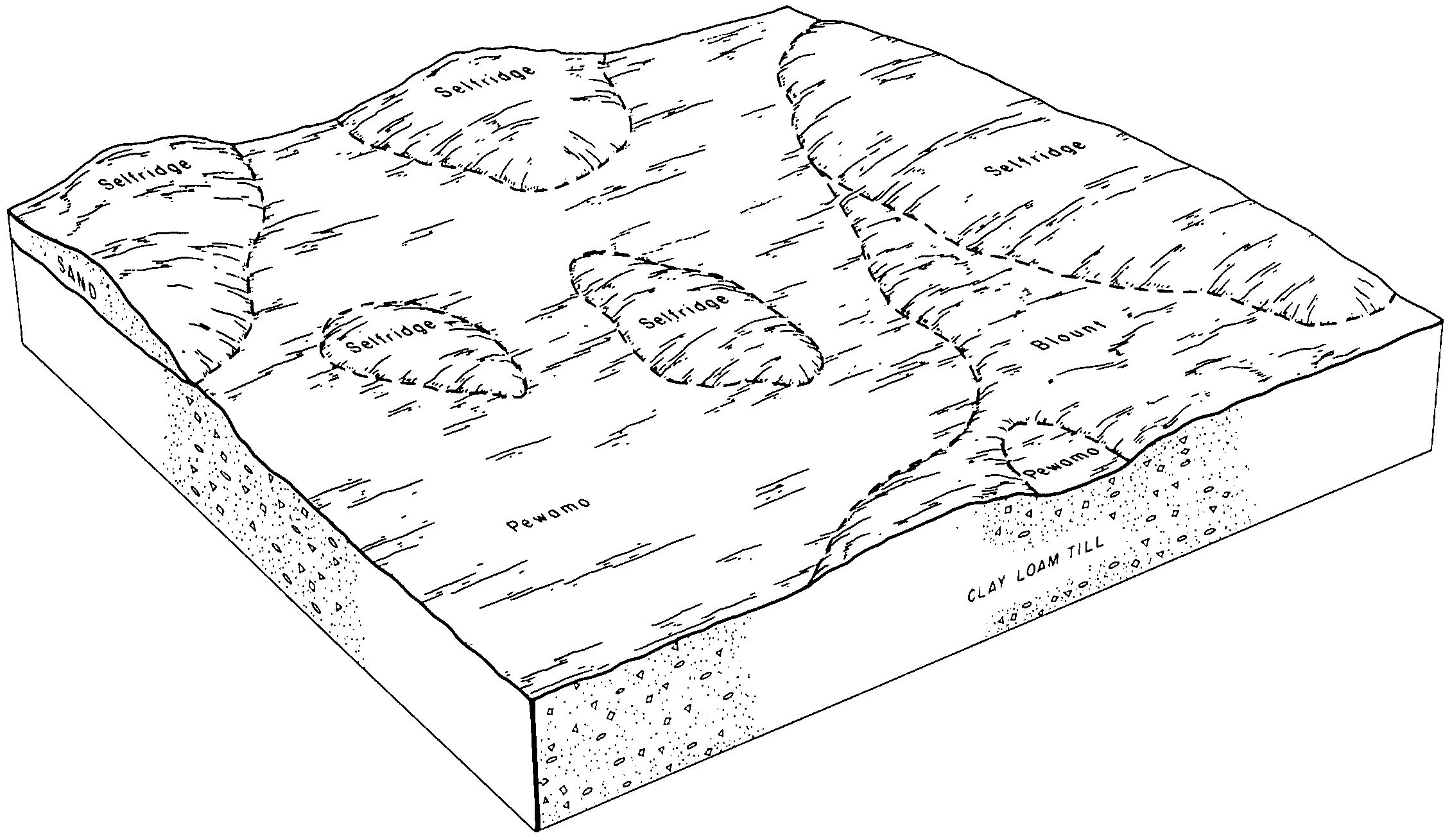
| Selfridge-Crosier complex, 0 to 1 percent slopes | SdzA | 879 | 165468 | 5k5p | in039 | 1997 | 1:12000 |
Selfridge-Brems complex, 1 to 4 percent slopes | SdzaB | 622 | 165469 | 5k5q | in039 | 1997 | 1:12000 |
Selfridge loamy fine sand, 0 to 2 percent slopes | SeA | 2599 | 272691 | 94rh | in091 | 1979 | 1:15840 |
Selfridge loamy fine sand, 2 to 6 percent slopes | SeB | 1767 | 272692 | 94rj | in091 | 1979 | 1:15840 |
Selfridge-Crosier complex, 0 to 1 percent slopes | SdzA | 6126 | 2453035 | 2nbl5 | in099 | 1978 | 1:15840 |
Selfridge-Brems loamy sands, 1 to 4 percent slopes | SdzaB | 1 | 2495704 | 2qnfc | in099 | 1978 | 1:15840 |
Selfridge loamy fine sand | Se | 807 | 160685 | 5d6d | in127 | 1978 | 1:15840 |
Moon-Selfridge complex, 0 to 1 percent slopes | MtpA | 7700 | 184949 | 66g3 | in131 | 2001 | 1:12000 |
Selfridge loamy fine sand, 0 to 1 percent slopes | SgzA | 2008 | 184977 | 66h0 | in131 | 2001 | 1:12000 |
Selfridge-Brems loamy fine sands, 1 to 4 percent slopes | SdzcB | 460 | 184990 | 66hf | in131 | 2001 | 1:12000 |
Selfridge-Morocco loamy fine sands, 0 to 1 percent slopes | ShaA | 342 | 184978 | 66h1 | in131 | 2001 | 1:12000 |
Selfridge-Crosier complex, 0 to 1 percent slopes | SdzA | 798 | 612329 | nk5k | in141 | 2001 | 1:12000 |
Selfridge-Brems loamy sands, 1 to 4 percent slopes | SdzaB | 124 | 612342 | nk5z | in141 | 2001 | 1:12000 |
Selfridge loamy sand, 0 to 3 percent slopes | WxA | 7312 | 2507836 | 2whvw | mi011 | 1964 | 1:20000 |
Londo-Selfridge complex, 0 to 5 percent slopes | LwB | 79 | 2507828 | 2whvz | mi011 | 1964 | 1:20000 |
Selfridge loamy sand, 0 to 4 percent slopes | 37B | 987 | 186094 | 67n1 | mi015 | 1988 | 1:15840 |
Selfridge loamy sand, 0 to 3 percent slopes | 17A | 24815 | 186528 | 2whvw | mi017 | 1978 | 1:20000 |
Londo-Selfridge complex, 0 to 5 percent slopes | 64B | 3864 | 186550 | 2whvz | mi017 | 1978 | 1:20000 |
Selfridge loamy sand, 0 to 3 percent slopes | 64A | 5450 | 186195 | 67r9 | mi021 | 1979 | 1:15840 |
Selfridge loamy sand, till plain, 0 to 4 percent slopes | SeA | 1206 | 186397 | 67yt | mi037 | 1974 | 1:15840 |
Selfridge loamy sand, 0 to 3 percent slopes | SfA | 421 | 2673658 | 2whvw | mi037 | 1974 | 1:15840 |
Selfridge loamy sand, 0 to 3 percent slopes | SdA | 6684 | 186892 | 2whvw | mi049 | 1967 | 1:20000 |
Parkhill-Selfridge complex, 0 to 2 percent slopes | PcB | 6 | 2399409 | 2whvy | mi049 | 1967 | 1:20000 |
Selfridge loamy sand, 0 to 3 percent slopes | WxA | 11713 | 2507849 | 2whvw | mi051 | 1966 | 1:15840 |
Selfridge stony sand, 0 to 2 percent slopes, bouldery | IdA | 229 | 189793 | 2whw0 | mi051 | 1966 | 1:15840 |
Londo-Selfridge complex, 0 to 5 percent slopes | LpB | 211 | 2507842 | 2whvz | mi051 | 1966 | 1:15840 |
Selfridge loamy sand, 0 to 3 percent slopes | WxA | 18194 | 187054 | 2whvw | mi057 | 1975 | 1:12000 |
Selfridge loamy sand, till plain, 0 to 2 percent slopes | SeA | 6001 | 187039 | 68mj | mi057 | 1975 | 1:12000 |
Parkhill-Selfridge complex, 0 to 2 percent slopes | PcB | 14 | 2673591 | 2whvy | mi057 | 1975 | 1:12000 |
Selfridge loamy sand, 0 to 3 percent slopes | 102A | 14758 | 2673517 | 2whvw | mi073 | 1983 | 1:15840 |
Selfridge sand, 0 to 3 percent slopes | 61A | 4790 | 186572 | 684g | mi073 | 1983 | 1:15840 |
Ithaca-Selfridge complex, 0 to 4 percent slopes | 70B | 1497 | 186587 | 684y | mi073 | 1983 | 1:15840 |
Selfridge loamy sand, 0 to 4 percent slopes | 49B | 4320 | 187159 | 68rd | mi081 | 1984 | 1:15840 |
Selfridge loamy sand, 0 to 3 percent slopes | SdA | 1863 | 2409422 | 2whvw | mi087 | 1966 | 1:15840 |
Selfridge-Pewamo complex, 0 to 3 percent slopes | ShA | 86 | 2509151 | 68tp | mi091 | 1957 | 1:20000 |
Selfridge loamy sand, 0 to 3 percent slopes | SdA | 17982 | 187680 | 2whvw | mi099 | 1967 | 1:20000 |
Brevort-Selfridge complex | Bx | 3955 | 187626 | 697g | mi099 | 1967 | 1:20000 |
Lenawee-Selfridge complex, 0 to 3 percent slopes | Lk | 3825 | 187654 | 2whvx | mi099 | 1967 | 1:20000 |
Selfridge-Lamson complex, 0 to 2 percent slopes | SeA | 807 | 187682 | 6998 | mi099 | 1967 | 1:20000 |
Selfridge loamy sand, 0 to 3 percent slopes | SeA | 35448 | 2673561 | 2whvw | mi111 | 1976 | 1:15840 |
Lenawee-Selfridge complex, 0 to 3 percent slopes | LrB | 2030 | 186640 | 2whvx | mi111 | 1976 | 1:15840 |
Parkhill-Selfridge complex, 0 to 2 percent slopes | PbB | 128 | 2673552 | 2whvy | mi111 | 1976 | 1:15840 |
Selfridge-Pewamo complex, 0 to 3 percent slopes | 20A | 23761 | 187230 | 68tp | mi115 | 1980 | 1:15840 |
Selfridge loamy sand, 0 to 3 percent slopes | 19A | 22238 | 187229 | 2whvw | mi115 | 1980 | 1:15840 |
Urban land-Selfridge-Pewamo complex, 0 to 3 percent slopes | 59A | 1329 | 187264 | 68vs | mi115 | 1980 | 1:15840 |
Selfridge-Capac complex, 0 to 5 percent slopes | 13B | 6765 | 186440 | 6806 | mi123 | 1990 | 1:15840 |
Selfridge loamy sand, 0 to 4 percent slopes | 92B | 6070 | 186517 | 682p | mi123 | 1990 | 1:15840 |
Selfridge loamy sand, 0 to 3 percent slopes | 52A | 2281 | 188863 | 2whvw | mi125 | 1980 | 1:15840 |
Selfridge loamy sand, 0 to 3 percent slopes | 124A | 51662 | 2399405 | 2whvw | mi145 | 1991 | 1:15840 |
Parkhill-Selfridge complex, 0 to 2 percent slopes | 22B | 16082 | 186665 | 2whvy | mi145 | 1991 | 1:15840 |
Selfridge loamy sand, 0 to 3 percent slopes | SfA | 189 | 3045067 | 2whvw | mi151 | 1955 | 1:15840 |
Selfridge loamy sand, 0 to 3 percent slopes | SfA | 2013 | 2395912 | 2whvw | mi155 | 1967 | 1:12000 |
Selfridge loamy sand, 0 to 3 percent slopes | 115A | 12373 | 2397059 | 2whvw | mi157 | 1984 | 1:15840 |
Selfridge loamy sand, 0 to 3 percent slopes | 47A | 23348 | 186326 | 67wj | mi159 | 1984 | 1:15840 |
Selfridge loamy sand, 0 to 3 percent slopes | SeA | 9319 | 3015061 | 2whvw | mi163 | 1974 | 1:12000 |
Selfridge-Pewamo complex, 0 to 2 percent slopes | SfA | 4758 | 3015062 | 6bkx | mi163 | 1974 | 1:12000 |
Selfridge-Pewamo-Metea complex, 0 to 4 percent slopes | SgB | 2190 | 3015063 | 6bky | mi163 | 1974 | 1:12000 |
Selfridge-Pewamo complex, 0 to 3 percent slopes | SdA | 443 | 3015096 | 68tp | mi163 | 1974 | 1:12000 |


