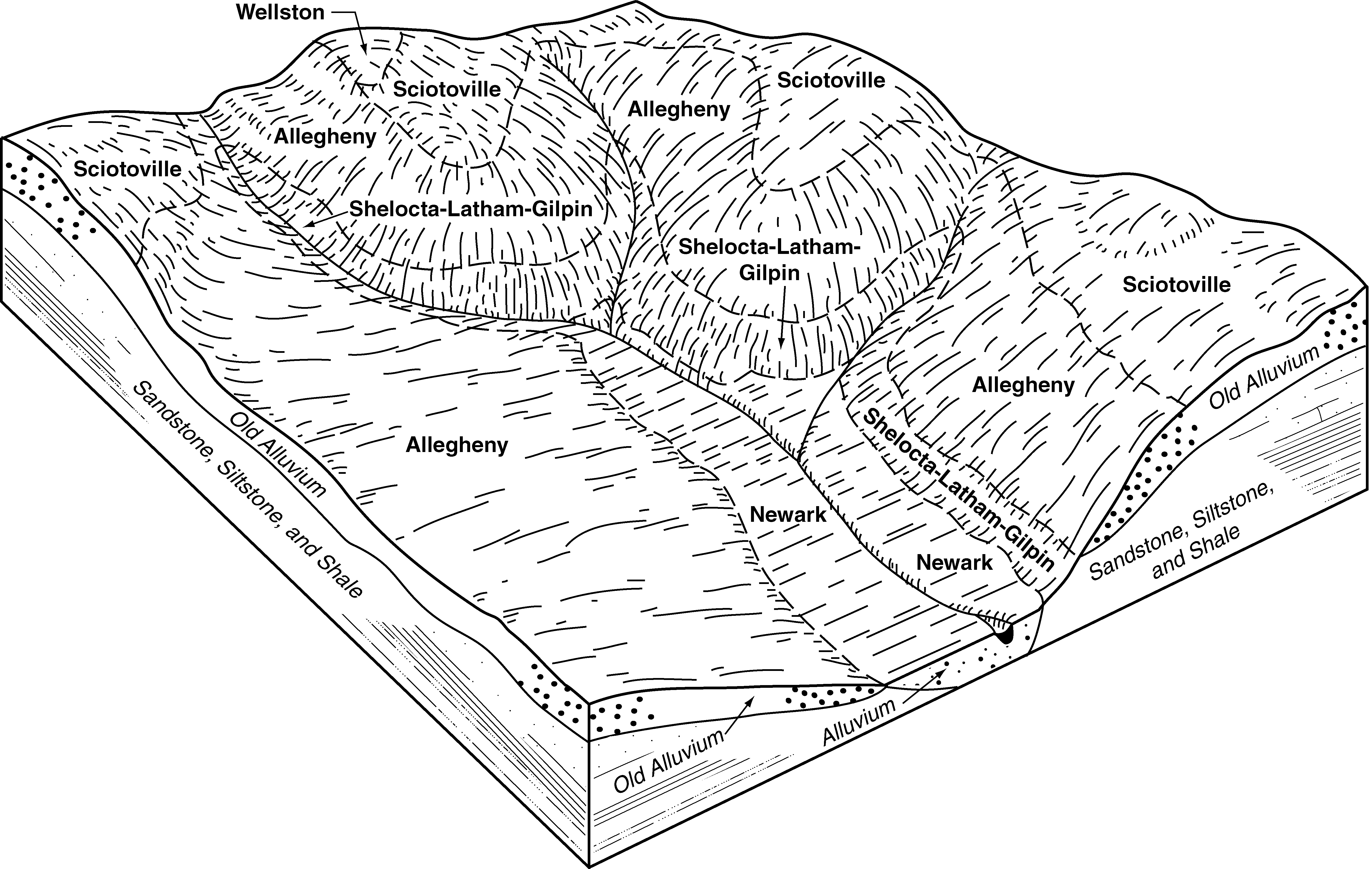
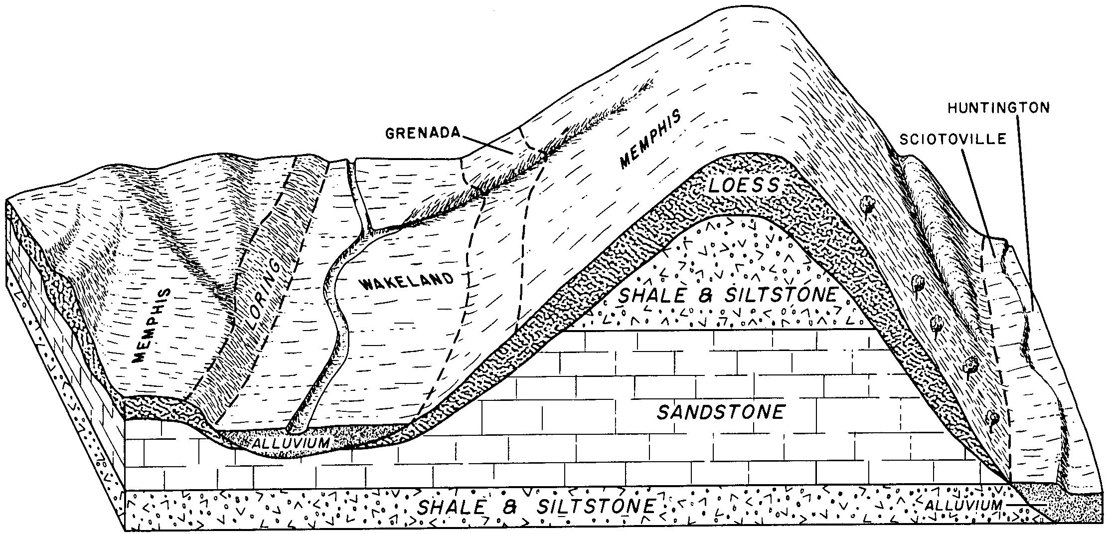
| Sciotoville silt loam, 2 to 5 percent slopes, rarely flooded | 7462B | 392 | 602352 | n6sq | il003 | 2002 | 1:12000 |
Sciotoville silt loam, 0 to 2 percent slopes, rarely flooded | 7462A | 351 | 602351 | n6sp | il003 | 2002 | 1:12000 |
Sciotoville silt loam, 5 to 10 percent slopes, eroded, rarely flooded | 7462C2 | 161 | 602353 | n6sr | il003 | 2002 | 1:12000 |
Sciotoville silt loam, 10 to 18 percent slopes, severely eroded, rarely flooded | 7462D3 | 70 | 602356 | n6sv | il003 | 2002 | 1:12000 |
Sciotoville silt loam, 10 to 18 percent slopes, eroded, rarely flooded | 7462D2 | 21 | 602355 | n6st | il003 | 2002 | 1:12000 |
Sciotoville silt loam, 5 to 10 percent slopes, severely eroded, rarely flooded | 7462C3 | 14 | 602354 | n6ss | il003 | 2002 | 1:12000 |
Sciotoville silt loam, 4 to 7 percent slopes, eroded | 462C2 | 711 | 211669 | 7381 | il059 | 1966 | 1:20000 |
Sciotoville silt loam, 2 to 4 percent slopes | 462B | 615 | 211668 | 7380 | il059 | 1966 | 1:20000 |
Sciotoville silt loam, 0 to 2 percent slopes | 462A | 396 | 211667 | 737z | il059 | 1966 | 1:20000 |
Sciotoville silt loam, 7 to 12 percent slopes, eroded | 462D2 | 341 | 211670 | 7382 | il059 | 1966 | 1:20000 |
Sciotoville silt loam, 12 to 25 percent slopes, eroded | 462E2 | 129 | 211671 | 7383 | il059 | 1966 | 1:20000 |
Sciotoville silt loam, 5 to 10 percent slopes, eroded, rarely flooded | 7462C2 | 511 | 714019 | ryzw | il069 | 2003 | 1:12000 |
Sciotoville silt loam, 2 to 5 percent slopes, rarely flooded | 7462B | 365 | 714018 | ryzv | il069 | 2003 | 1:12000 |
Sciotoville silt loam, 10 to 18 percent slopes, eroded, rarely flooded | 7462D2 | 249 | 714021 | ryzy | il069 | 2003 | 1:12000 |
Sciotoville silt loam, 10 to 18 percent slopes, severely eroded, rarely flooded | 7462D3 | 93 | 714022 | ryzz | il069 | 2003 | 1:12000 |
Sciotoville silt loam, 0 to 2 percent slopes, rarely flooded | 7462A | 18 | 714017 | ryzt | il069 | 2003 | 1:12000 |
Sciotoville silt loam, 2 to 5 percent slopes, rarely flooded | 7462B | 422 | 1146425 | 17gyg | il087 | 2005 | 1:12000 |
Sciotoville silt loam, 0 to 2 percent slopes, rarely flooded | 7462A | 286 | 1146424 | 17gyf | il087 | 2005 | 1:12000 |
Sciotoville silt loam, 5 to 10 percent slopes, eroded, rarely flooded | 7462C2 | 181 | 1146426 | 17gyh | il087 | 2005 | 1:12000 |
Sciotoville silt loam, 10 to 18 percent slopes, eroded, rarely flooded | 7462D2 | 26 | 1146428 | 17gyk | il087 | 2005 | 1:12000 |
Sciotoville silt loam, 5 to 10 percent slopes, severely eroded, rarely flooded | 7462C3 | 22 | 1603841 | 1qtxt | il087 | 2005 | 1:12000 |
Sciotoville silt loam, 2 to 5 percent slopes, rarely flooded | 7462B | 2332 | 808116 | w3x8 | il127 | 2004 | 1:12000 |
Sciotoville silt loam, 0 to 2 percent slopes, rarely flooded | 7462A | 899 | 808115 | w3x7 | il127 | 2004 | 1:12000 |
Sciotoville silt loam, 5 to 10 percent slopes, eroded, rarely flooded | 7462C2 | 800 | 808117 | w3x9 | il127 | 2004 | 1:12000 |
Sciotoville silt loam, 10 to 18 percent slopes, eroded, rarely flooded | 7462D2 | 296 | 808119 | w3xc | il127 | 2004 | 1:12000 |
Sciotoville silt loam, 10 to 18 percent slopes, severely eroded, rarely flooded | 7462D3 | 36 | 808120 | w3xd | il127 | 2004 | 1:12000 |
Sciotoville silt loam, 5 to 10 percent slopes, severely eroded, rarely flooded | 7462C3 | 25 | 808118 | w3xb | il127 | 2004 | 1:12000 |
Sciotoville silt loam, 2 to 5 percent slopes, rarely flooded | 7462B | 1371 | 608083 | ndrl | il151 | 2003 | 1:12000 |
Sciotoville silt loam, 5 to 10 percent slopes, eroded, rarely flooded | 7462C2 | 1133 | 608084 | ndrm | il151 | 2003 | 1:12000 |
Sciotoville silt loam, 0 to 2 percent slopes, rarely flooded | 7462A | 728 | 608082 | ndrk | il151 | 2003 | 1:12000 |
Sciotoville silt loam, 10 to 18 percent slopes, eroded, rarely flooded | 7462D2 | 306 | 608086 | ndrp | il151 | 2003 | 1:12000 |
Sciotoville silt loam, 5 to 10 percent slopes, severely eroded, rarely flooded | 7462C3 | 50 | 608085 | ndrn | il151 | 2003 | 1:12000 |
Sciotoville silt loam, 10 to 18 percent slopes, severely eroded, rarely flooded | 7462D3 | 11 | 608087 | ndrq | il151 | 2003 | 1:12000 |
Sciotoville silt loam, 2 to 5 percent slopes, rarely flooded | 7462B | 1395 | 748995 | t4d4 | il153 | 2004 | 1:12000 |
Sciotoville silt loam, 5 to 10 percent slopes, eroded, rarely flooded | 7462C2 | 824 | 748996 | t4d5 | il153 | 2004 | 1:12000 |
Sciotoville silt loam, 0 to 2 percent slopes, rarely flooded | 7462A | 557 | 748994 | t4d3 | il153 | 2004 | 1:12000 |
Sciotoville silt loam, 5 to 10 percent slopes, severely eroded, rarely flooded | 7462C3 | 206 | 748997 | t4d6 | il153 | 2004 | 1:12000 |
Sciotoville silt loam, 10 to 18 percent slopes, eroded, rarely flooded | 7462D2 | 75 | 748998 | t4d7 | il153 | 2004 | 1:12000 |
Sciotoville silt loam, 10 to 18 percent slopes, severely eroded, rarely flooded | 7462D3 | 49 | 748999 | t4d8 | il153 | 2004 | 1:12000 |
Sciotoville silt loam, 0 to 2 percent slopes, rarely flooded | 7462A | 1844 | 1543968 | 1ntmf | il193 | 2006 | 1:12000 |
Sciotoville silt loam, 2 to 5 percent slopes, rarely flooded | 7462B | 684 | 1543969 | 1ntmg | il193 | 2006 | 1:12000 |
Sciotoville silt loam, 2 to 6 percent slopes, eroded | ScbB2 | 166 | 185254 | 66ry | in043 | 2000 | 1:12000 |
Sciotoville silt loam, 0 to 2 percent slopes | ScbA | 100 | 185253 | 66rx | in043 | 2000 | 1:12000 |
Sciotoville silt loam, 2 to 6 percent slopes, eroded | ScbB2 | 554 | 1585860 | 1q76s | in061 | 2007 | 1:12000 |
Sciotoville silt loam, 0 to 2 percent slopes | ScbA | 397 | 1152204 | 17nyw | in061 | 2007 | 1:12000 |
Sciotoville silt loam, 2 to 4 percent slopes | ScdB | 493 | 535897 | kzn0 | in123 | 1997 | 1:12000 |
Sciotoville silt loam, 0 to 2 percent slopes | ScbA | 478 | 535896 | kzmz | in123 | 1997 | 1:12000 |
Sciotoville silt loam, 2 to 4 percent slopes, rarely flooded | ScdBQ | 279 | 535988 | kzqy | in123 | 1997 | 1:12000 |
Sciotoville silt loam, 0 to 2 percent slopes, rarely flooded | ScbAQ | 222 | 535989 | kzqz | in123 | 1997 | 1:12000 |
Sciotoville silt loam, 0 to 2 percent slopes | ScA | 2499 | 160047 | 5cjt | in147 | 1966 | 1:15840 |
Sciotoville silt loam, 2 to 6 pecent slopes, eroded | ScB2 | 1395 | 160048 | 5cjv | in147 | 1966 | 1:15840 |
Sciotoville silt loam, 0 to 2 percent slopes | ScA | 3567 | 162766 | 5gcj | in163 | 1972 | 1:15840 |
Sciotoville silt loam, 2 to 6 percent slopes, eroded | ScB2 | 538 | 162767 | 5gck | in163 | 1972 | 1:15840 |
Sciotoville silt loam, 1 to 3 percent slopes | ScA | 391 | 159975 | 5cgh | in173 | 1976 | 1:15840 |
Sciotoville fine sandy loam, 0 to 2 percent slopes | ScA | 502 | 549229 | lfj2 | ky101 | 1964 | 1:15840 |
Sciotoville fine sandy loam, 2 to 6 percent slopes | ScB | 103 | 549230 | lfj3 | ky101 | 1964 | 1:15840 |
Urban land-Alfic Udarents-Sciotoville complex, 0 to 12 percent slopes | UvC | 2108 | 1533095 | 1ng9p | ky111 | 2005 | 1:12000 |
Sciotoville silt loam, 0 to 2 percent slopes | ScA | 850 | 1533028 | 1ng7j | ky111 | 2005 | 1:12000 |
Sciotoville silt loam, 2 to 6 percent slopes | ScB | 372 | 1533029 | 1ng7k | ky111 | 2005 | 1:12000 |
Sciotoville silt loam, 6 to 12 percent slopes | ScC | 49 | 1533030 | 1ng7l | ky111 | 2005 | 1:12000 |
Sciotoville silt loam, 0 to 2 percent slopes, occasionally flooded | SdA | 42 | 1533025 | 1ng7f | ky111 | 2005 | 1:12000 |
Sciotoville silt loam, 2 to 6 percent slopes, occasionally flooded | SdB | 39 | 1533026 | 1ng7g | ky111 | 2005 | 1:12000 |
Sciotoville silt loam, 2 to 6 percent slopes | ScB | 2003 | 549626 | lfxw | ky607 | 1992 | 1:20000 |
Sciotoville silt loam, 0 to 2 percent slopes | ScA | 405 | 549625 | lfxv | ky607 | 1992 | 1:20000 |
Sciotoville loam, 0 to 2 percent slopes | ScA | 316 | 549421 | lfq8 | ky615 | 1971 | 1:20000 |
Sciotoville silt loam, 2 to 6 percent slopes | ScB | 1054 | 2452905 | 2nbfz | ky709 | 1995 | 1:20000 |
Sciotoville silt loam, 6 to 12 percent slopes, eroded | ScC2 | 116 | 2452906 | 2nbg0 | ky709 | 1995 | 1:20000 |
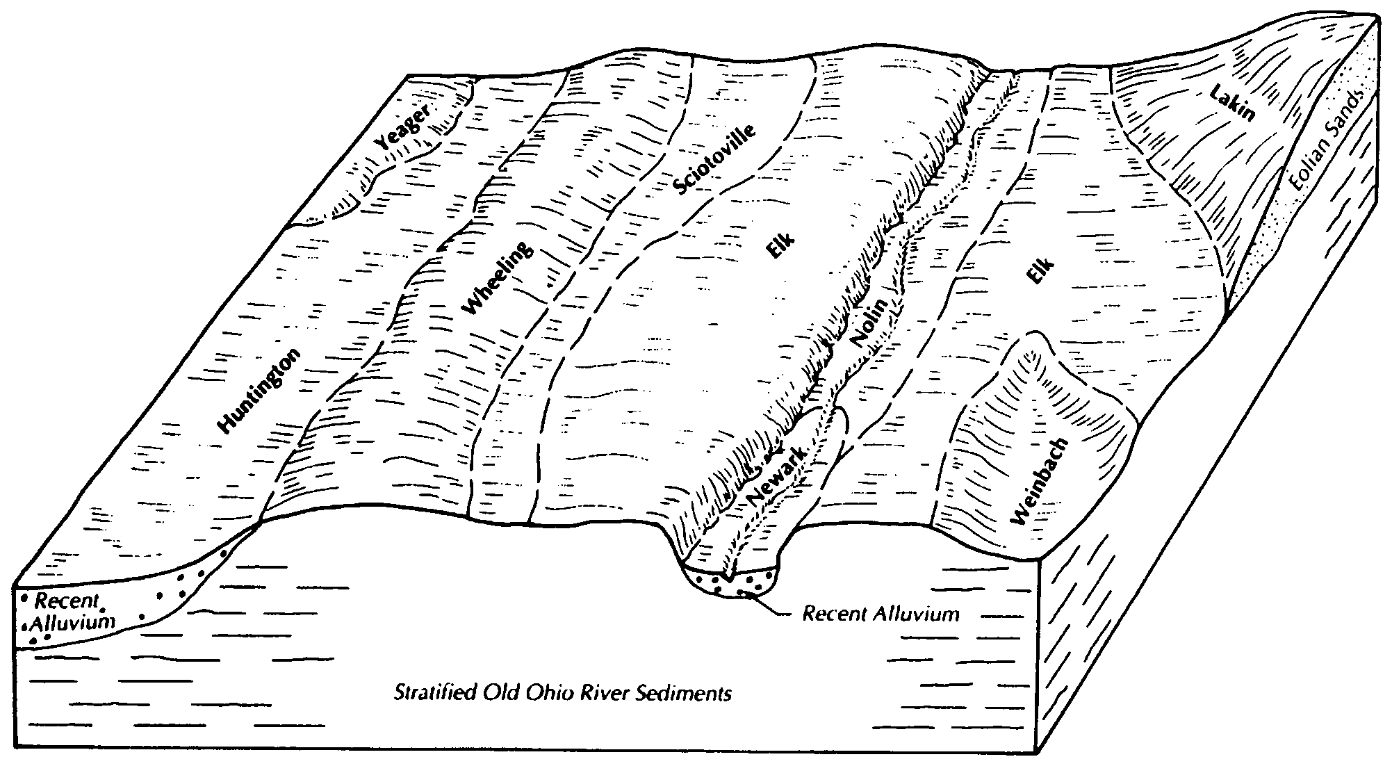
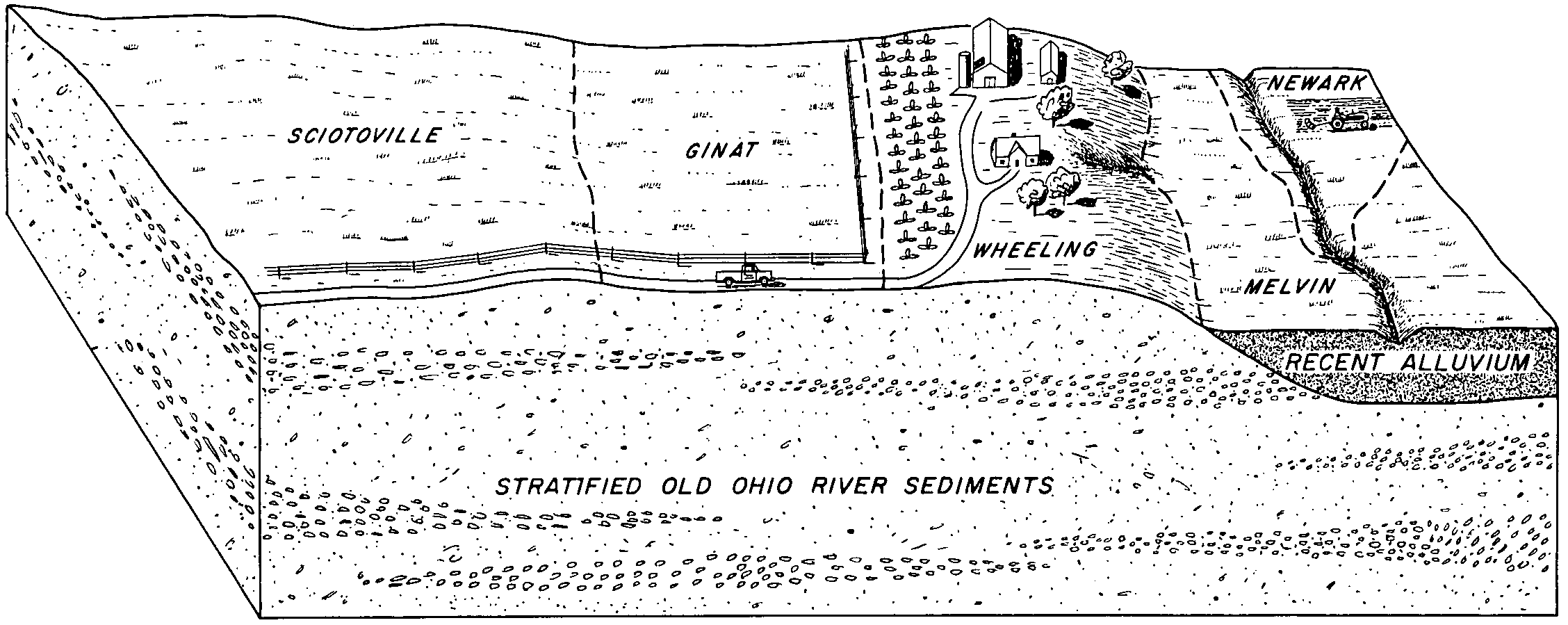
Sciotoville silt loam, 1 to 6 percent slopes | ScB | 1325 | 170118 | 5q0p | oh001 | 1987 | 1:15840 |
Sciotoville silt loam, 1 to 8 percent slopes | SdB | 6 | 1895884 | 21mtk | oh001 | 1987 | 1:15840 |
Sciotoville silt loam, 0 to 2 percent slopes | ScA | 759 | 169736 | 5pmc | oh015 | 1987 | 1:15840 |
Sciotoville silt loam, 0 to 2 percent slopes | ScA | 75 | 2440348 | 2mxcx | oh025 | 1972 | 1:20000 |
Sciotoville silt loam, 1 to 6 percent slopes | SaB | 1421 | 536176 | kzy0 | oh087 | 1989 | 1:15840 |
Sciotoville silt loam, 1 to 8 percent slopes | ScB | 118 | 1455091 | 1kv4f | oh087 | 1989 | 1:15840 |
Sciotoville silt loam, 0 to 4 percent slopes | ScB | 324 | 537816 | l1mx | oh111 | 1968 | 1:15840 |
Sciotoville silt loam, 1 to 8 percent slopes | SacB | 2161 | 537307 | l13h | oh145 | 1984 | 1:15840 |
Sciotoville silt loam, 2 to 6 percent slopes | ScB | 2601 | 2421658 | 2m8y0 | pa005 | 2012 | 1:24000 |
Sciotoville silt loam, 6 to 12 percent slopes | ScC | 1826 | 2421659 | 2m8y1 | pa005 | 2012 | 1:24000 |
Sciotoville silt loam, 0 to 2 percent slopes | ScA | 316 | 2421661 | 2m8y3 | pa005 | 2012 | 1:24000 |
Sciotoville silt loam, 0 to 2 percent slopes | ScA | 1293 | 563788 | lxnq | pa031 | 2012 | 1:24000 |
Sciotoville silt loam, 2 to 6 percent slopes | ScB | 1208 | 563789 | lxnr | pa031 | 2012 | 1:24000 |
Sciotoville silt loam, 6 to 12 percent slopes | ScC | 222 | 1292511 | 1dcyx | pa031 | 2012 | 1:24000 |
Sciotoville silt loam, 6 to 12 percent slopes | ScC | 303 | 544673 | l8s3 | pa129 | 2003 | 1:24000 |
Sciotoville silt loam, 2 to 6 percent slopes | ScB | 292 | 544672 | l8s2 | pa129 | 2003 | 1:24000 |
Sciotoville silt loam, 3 to 10 percent slopes | ScB | 341 | 514635 | k8j4 | wv601 | 1966 | 1:15840 |
Sciotoville silt loam, 0 to 3 percent slopes | ScA | 151 | 514634 | k8j3 | wv601 | 1966 | 1:15840 |