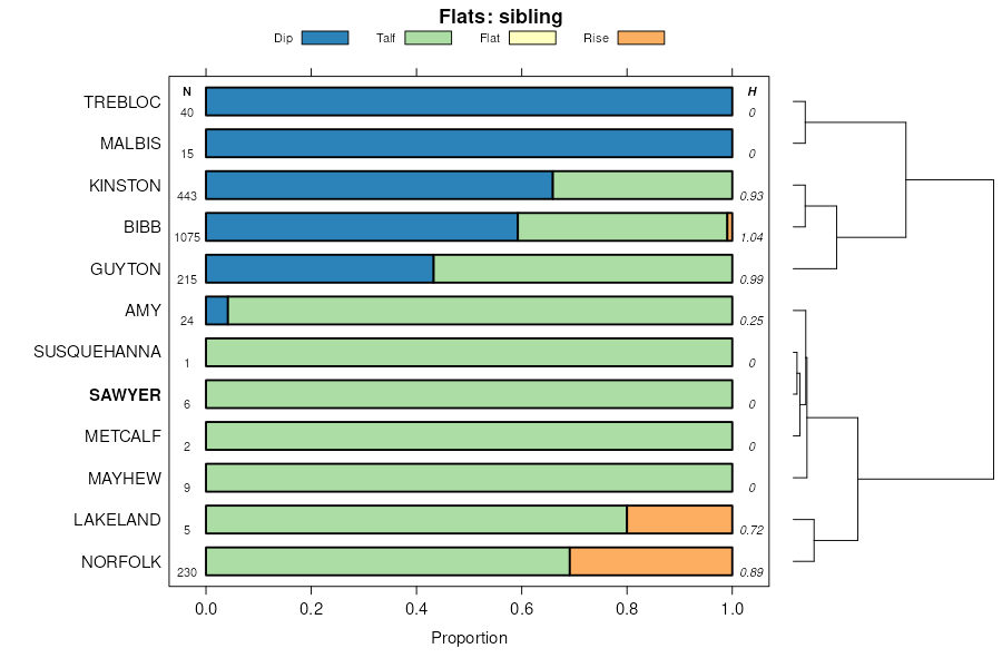
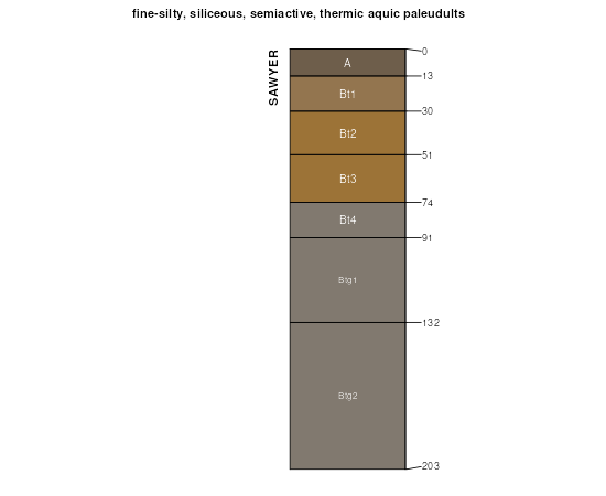
| Sawyer fine sandy loam | Sa | 382 | 329291 | c1n9 | al051 | 1948 | 1:20000 |
Sawyer fine sandy loam, 0 to 2 percent slopes | SeA | 1320 | 329704 | c22m | al063 | 2013 | 1: |
Sawyer fine sandy loam, eroded, very gently sloping phase | SbB2 | 2417 | 330956 | c3d0 | al101 | 1958 | 1:20000 |
Sawyer fine sandy loam, eroded, gently sloping phase | SbC2 | 1524 | 330957 | c3d1 | al101 | 1958 | 1:20000 |
Sawyer fine sandy loam, eroded, sloping phase | SbD2 | 780 | 330958 | c3d2 | al101 | 1958 | 1:20000 |
Sawyer fine sandy loam, very gently sloping phase | SbB | 598 | 330955 | c3cz | al101 | 1958 | 1:20000 |
Sawyer sandy clay loam, severely eroded, sloping phase | ScD3 | 479 | 330960 | c3d4 | al101 | 1958 | 1:20000 |
Sawyer sandy clay loam, severely eroded, gently sloping phase | ScC3 | 274 | 330959 | c3d3 | al101 | 1958 | 1:20000 |
Sawyer very fine sandy loam, nearly level phase | SfB | 3187 | 565196 | lz44 | ar011 | 1959 | 1:20000 |
Sawyer very fine sandy loam, eroded nearly level phase | SfB2 | 2473 | 565197 | lz45 | ar011 | 1959 | 1:20000 |
Sawyer very fine sandy loam, eroded gently sloping phase | SfC2 | 1264 | 565199 | lz47 | ar011 | 1959 | 1:20000 |
Sawyer very fine sandy loam, gently sloping phase | SfC | 1188 | 565198 | lz46 | ar011 | 1959 | 1:20000 |
Sawyer very fine sandy loam, level phase | SfA | 606 | 565195 | lz43 | ar011 | 1959 | 1:20000 |
Sawyer very fine sandy loam, moderately steep phase (sacul) | SfE | 217 | 565200 | lz48 | ar011 | 1959 | 1:20000 |
Sawyer loam, 3 to 8 percent slopes | 72 | 3219 | 3179409 | lyp7 | ar019 | 1983 | 1:20000 |
Sawyer loam, 1 to 3 percent slopes | 71 | 2429 | 3179408 | lyp6 | ar019 | 1983 | 1:20000 |
Sawyer very fine sandy loam, 1 to 8 percent slopes | 14C | 21093 | 1715906 | 1vljt | ar053 | 2006 | 1:24000 |
Sawyer loam, 3 to 8 percent slopes | 44 | 16532 | 565671 | lzmg | ar057 | 1976 | 1:20000 |
Sawyer loam, 1 to 3 percent slopes | 43 | 10231 | 565670 | lzmf | ar057 | 1976 | 1:20000 |
Sawyer loam, 3 to 8 percent slopes | 72 | 2651 | 3179299 | lyp7 | ar059 | 1983 | 1:20000 |
Sawyer loam, 1 to 3 percent slopes | 71 | 2223 | 3179298 | lyp6 | ar059 | 1983 | 1:20000 |
Sawyer very fine sandy loam, 3 to 8 percent slopes | SrC | 21622 | 721518 | s6ss | ar099 | 2000 | 1:24000 |
Sawyer very fine sandy loam, 1 to 3 percent slopes | SrB | 1637 | 721517 | s6sr | ar099 | 2000 | 1:24000 |
Sacul-Sawyer complex, 1 to 8 percent slopes | ScC | 176645 | 579207 | 2zry6 | ar139 | 1992 | 1:24000 |
Sacul-Sawyer complex, 8 to 15 percent slopes | ScD | 27350 | 579206 | mfq2 | ar139 | 1992 | 1:24000 |
Sawyer very fine sandy loam, 1 to 8 percent slopes | SeC | 23191 | 579188 | mfph | ar139 | 1992 | 1:24000 |
Sacul-Sawyer association, gently rolling | 19 | 20658 | 564673 | lyl8 | ar620 | 1977 | 1:20000 |
Sawyer silt loam, 3 to 8 percent slopes | 24 | 6284 | 564679 | lylg | ar620 | 1977 | 1:20000 |
Sawyer silt loam, 1 to 3 percent slopes | 23 | 2137 | 564678 | lylf | ar620 | 1977 | 1:20000 |
Sawyer silt loam, 3 to 8 percent slopes | 46 | 16325 | 564869 | lysl | ar660 | 1975 | 1:20000 |
Sawyer silt loam, 1 to 3 percent slopes | 45 | 12494 | 564868 | lysk | ar660 | 1975 | 1:20000 |
Sawyer silt loam, 1 to 3 percent slopes | 69 | 11829 | 564946 | lyw2 | ar670 | 1981 | 1:20000 |
Sawyer silt loam, 3 to 8 percent slopes | 70 | 4593 | 564948 | lyw4 | ar670 | 1981 | 1:20000 |
Sawyer silt loam, 3 to 8 percent slopes | 33 | 11462 | 564317 | ly6s | ar680 | 1980 | 1:20000 |
Sawyer-Susquehanna cobbly loamy sands, 2 to 8 percent slopes, eroded | SSC2 | 615 | 324660 | bwtx | ga095 | 1965 | 1:20000 |
Sawyer-Susquehanna loamy sands, 2 to 5 percent slopes, eroded | SUB2 | 610 | 324661 | bwty | ga095 | 1965 | 1:20000 |
Sawyer-Susquehanna cobbly loamy sands, 0 to 5 percent slopes | SSB | 595 | 324659 | bwtw | ga095 | 1965 | 1:20000 |
Sawyer loamy sand, 2 to 5 percent slopes | SfB | 3765 | 324824 | bx06 | ga165 | 1966 | 1:20000 |
Sawyer loamy sand, 5 to 8 percent slopes, eroded | SfC2 | 1595 | 324825 | bx07 | ga165 | 1966 | 1:20000 |
Sawyer, Norfolk, and Cuthbert loamy sands, 2 to 5 percent slopes | SlB | 1900 | 324998 | bx5t | ga283 | 1962 | 1:20000 |
Sawyer, Norfolk, and Cuthbert loamy sands, 5 to 8 percent slopes, eroded | SlC2 | 780 | 325001 | bx5x | ga283 | 1962 | 1:20000 |
Sawyer, Norfolk, and Cuthbert loamy sands, 2 to 5 percent slopes, eroded | SlB2 | 765 | 324999 | bx5v | ga283 | 1962 | 1:20000 |
Sawyer, Norfolk, and Cuthbert loamy sands, 5 to 8 percent slopes | SlC | 475 | 325000 | bx5w | ga283 | 1962 | 1:20000 |
Gilead (cowarts), Lakeland (blanton), and Sawyer (nankin) soils, 5 to 8 percent slopes | GCC | 2525 | 125071 | 464k | ga305 | 1962 | 1:20000 |
Gilead (cowarts), Lakeland (blanton), and Sawyer (nankin) soils, 2 to 5 percent slopes | GCB | 1960 | 125069 | 464h | ga305 | 1962 | 1:20000 |
Gilead (cowarts), Lakeland (blanton), and Sawyer (nankin) soils, 8 to 12 percent slopes | GCD | 825 | 125073 | 464m | ga305 | 1962 | 1:20000 |
Gilead (cowarts), Lakeland (blanton), and Sawyer (nankin) soils, 5 to 8 percent slopes, eroded | GCC2 | 625 | 125072 | 464l | ga305 | 1962 | 1:20000 |
Gilead (cowarts), Lakeland (blanton), and Sawyer (nankin) soils, 2 to 5 percent slopes, eroded | GCB2 | 575 | 125070 | 464j | ga305 | 1962 | 1:20000 |
Gilead (cowarts), Lakeland (blanton), and Sawyer (nankin) soils, 17 to 30 percent slopes, eroded | GCF2 | 280 | 125076 | 464q | ga305 | 1962 | 1:20000 |
Gilead (cowarts), Lakeland (blanton), and Sawyer (nankin) soils, 12 to 17 percent slopes, eroded | GCE2 | 270 | 125075 | 464p | ga305 | 1962 | 1:20000 |
Gilead (cowarts), Lakeland (blanton), and Sawyer (nankin) soils, 8 to 12 percent slopes, eroded | GCD2 | 240 | 125074 | 464n | ga305 | 1962 | 1:20000 |
Sawyer very fine sandy loam, 1 to 5 percent slopes | SnC | 18090 | 1724607 | 1vwlh | la013 | 1992 | 1:24000 |
Sawyer very fine sandy loam, 1 to 5 percent slopes | SnC | 65 | 1903221 | 21wg7 | la069 | 1983 | 1:24000 |
Sawyer very fine sandy loam, 1 to 5 percent slopes | SaC | 38 | 2401384 | 2llv0 | la081 | 1973 | 1:24000 |
Sawyer silt loam, 1 to 5 percent slopes | Sk | 11180 | 1725364 | 1vxcx | la111 | 1992 | 1:24000 |
Sawyer silt loam, 5 to 8 percent slopes | SL | 1864 | 1725365 | 1vxcy | la111 | 1992 | 1:24000 |
Sawyer very fine sandy loam, 1 to 5 percent slopes | SeC | 5981 | 1725573 | 1vxln | la115 | 1992 | 1:24000 |
Sawyer silt loam, 0 to 3 percent slopes | 36 | 111025 | 575282 | m9mh | tx037 | 1978 | 1:20000 |
Sawyer-Urban land complex, 0 to 3 percent slopes | 37 | 1757 | 575283 | m9mj | tx037 | 1978 | 1:20000 |
Sawyer very fine sandy loam, 0 to 2 percent slopes | SrA | 12429 | 576463 | mbvl | tx203 | 1989 | 1:24000 |