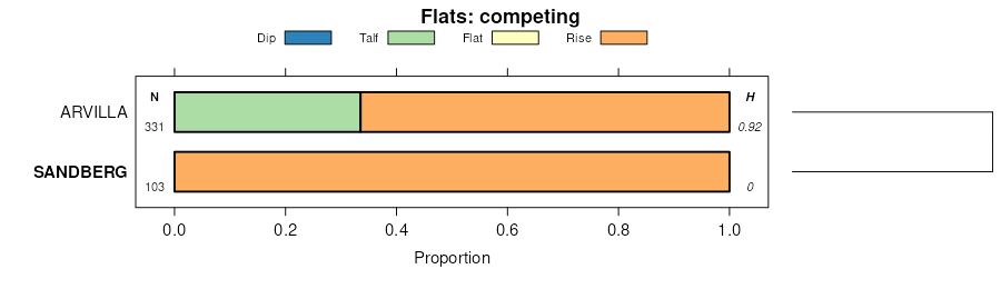
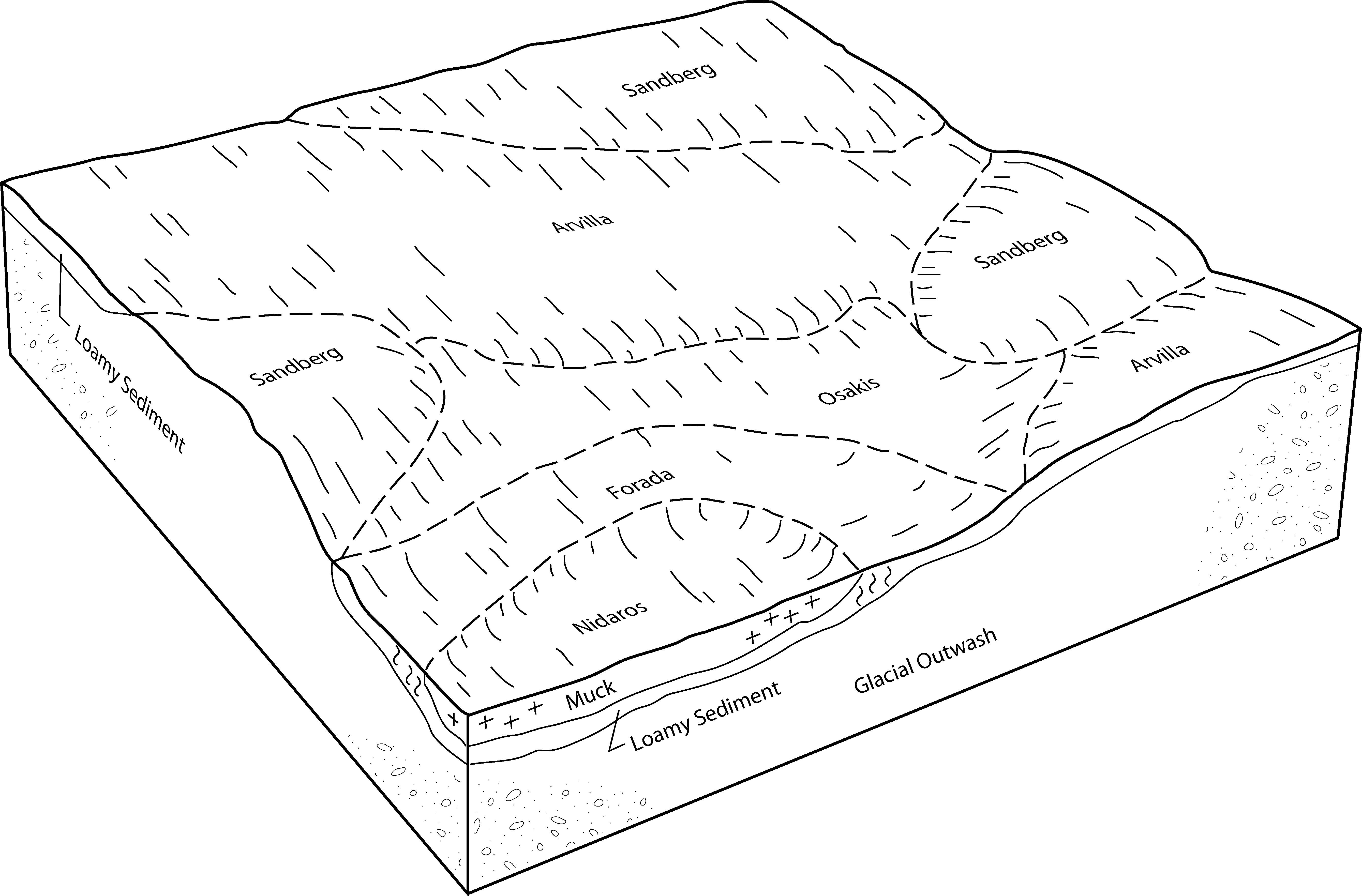
| Arvilla-Sandberg complex, 2 to 6 percent slopes | 711B | 5746 | 397548 | fbp4 | mn005 | 1994 | 1:20000 |
Arvilla-Sandberg complex, 6 to 12 percent slopes | 711C | 4904 | 397549 | fbp5 | mn005 | 1994 | 1:20000 |
Sandberg-Arvilla complex, 12 to 20 percent slopes | 1242D | 1901 | 397453 | fbl2 | mn005 | 1994 | 1:20000 |
Formdale-Buse-Sandberg complex, 2 to 6 percent slopes | 1235B | 1015 | 397448 | fbkx | mn005 | 1994 | 1:20000 |
Formdale-Langhei-Sandberg complex, 6 to 12 percent slopes, eroded | 579C2 | 954 | 397544 | fbp0 | mn005 | 1994 | 1:20000 |
Sandberg loamy coarse sand, 6 to 30 percent slopes | D8E | 277 | 753011 | 2w8fn | mn009 | 2007 | 1:12000 |
Sandberg gravelly sandy loam, 6 to 30 percent slopes | 402E | 558 | 396090 | 2w8fr | mn011 | 1990 | 1:20000 |
Sandberg sandy loam, 1 to 6 percent slopes | 402B | 461 | 396089 | 2w8fp | mn011 | 1990 | 1:20000 |
Sandberg-Arvilla complex, 6 to 12 percent slopes | J42C | 405 | 2423053 | 2mbd0 | mn023 | 1980 | 1:15840 |
Arvilla-Sandberg complex, 2 to 6 percent slopes | J31B | 295 | 2423044 | 2mbcq | mn023 | 1980 | 1:15840 |
Sandberg sandy loam, 1 to 6 percent slopes | 258B | 1674 | 3026305 | 2w8fp | mn027 | 1980 | 1:20000 |
Sandberg loamy coarse sand, 6 to 30 percent slopes | D8E | 1221 | 3026335 | 2w8fn | mn027 | 1980 | 1:20000 |
Sandberg loamy sand, 1 to 6 percent slopes | D8B | 678 | 3026301 | 2w8fl | mn027 | 1980 | 1:20000 |
Sandberg loamy sand, 2 to 12 percent slopes | D8C | 587 | 3026318 | 2w8fm | mn027 | 1980 | 1:20000 |
Sandberg sandy loam, 2 to 12 percent slopes | 258C | 354 | 3026319 | 2w8fq | mn027 | 1980 | 1:20000 |
Sandberg gravelly sandy loam, 6 to 30 percent slopes | 258E | 332 | 3026334 | 2w8fr | mn027 | 1980 | 1:20000 |
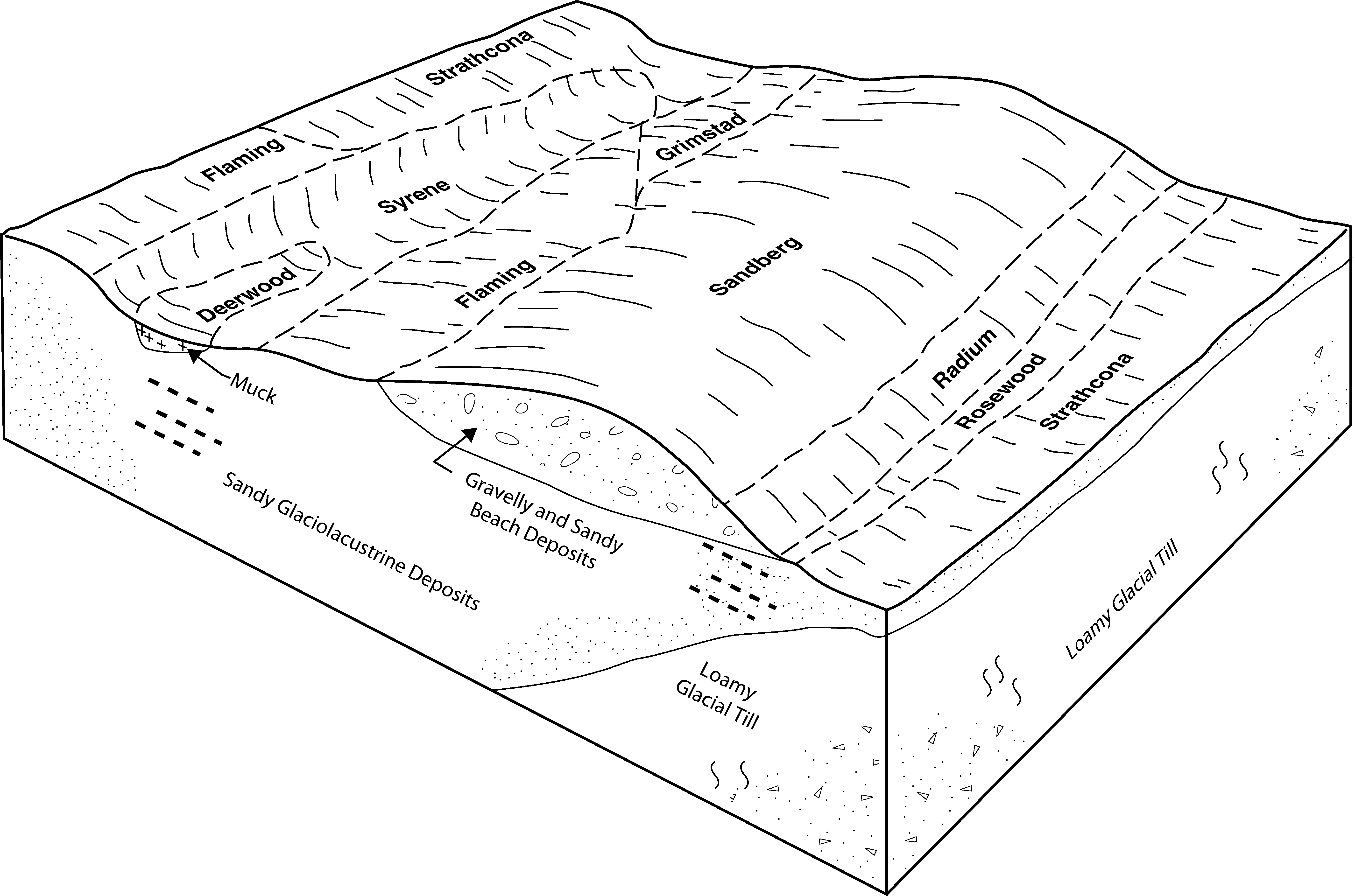
Sandberg-Radium complex, 0 to 6 percent slopes | I57B | 701 | 2798165 | prpd | mn029 | 1993 | 1:20000 |
Sandberg sandy loam, 1 to 6 percent slopes | 258B | 285 | 430471 | 2w8fp | mn029 | 1993 | 1:20000 |
Sandberg-Hubbard complex, Mississippi River Valley, 0 to 3 percent slopes | D97A | 330 | 2732684 | 2sln8 | mn035 | 2009 | 1:24000 |
Sandberg loamy sand, 2 to 12 percent slopes | D8C | 3439 | 3026320 | 2w8fm | mn041 | 1970 | 1:12000 |
Sandberg loamy sand, 1 to 6 percent slopes | D8B | 2912 | 3026302 | 2w8fl | mn041 | 1970 | 1:12000 |
Sandberg sandy loam, 2 to 12 percent slopes | 258C | 2389 | 3026321 | 2w8fq | mn041 | 1970 | 1:12000 |
Sandberg loamy coarse sand, 6 to 30 percent slopes | D8E | 2062 | 3026337 | 2w8fn | mn041 | 1970 | 1:12000 |
Sandberg gravelly sandy loam, 6 to 30 percent slopes | 258E | 2008 | 3026336 | 2w8fr | mn041 | 1970 | 1:12000 |
Sandberg sandy loam, 1 to 6 percent slopes | 258B | 610 | 3026306 | 2w8fp | mn041 | 1970 | 1:12000 |
Sandberg sandy loam, 1 to 6 percent slopes | 402B | 2640 | 398048 | 2w8fp | mn051 | 1974 | 1:20000 |
Sandberg sandy loam, 2 to 12 percent slopes | 402C | 2224 | 398049 | 2w8fq | mn051 | 1974 | 1:20000 |
Sandberg-Radium complex, 0 to 6 percent slopes | I57B | 889 | 2798180 | prpd | mn051 | 1974 | 1:20000 |
Sandberg gravelly sandy loam, 6 to 30 percent slopes | 402D | 500 | 398050 | 2w8fr | mn051 | 1974 | 1:20000 |
Sandberg loamy coarse sand, 6 to 30 percent slopes | D8E | 478 | 451626 | 2w8fn | mn053 | 2001 | 1:12000 |
Sandberg loamy coarse sand, 12 to 18 percent slopes | D8D | 212 | 451627 | h4ym | mn053 | 2001 | 1:12000 |
Sandberg loamy sand, 2 to 12 percent slopes | D8C | 146 | 451628 | 2w8fm | mn053 | 2001 | 1:12000 |
Sandberg loamy sand, 1 to 6 percent slopes | D8B | 26 | 451629 | 2w8fl | mn053 | 2001 | 1:12000 |
Sandberg loamy coarse sand, 6 to 30 percent slopes | D8E | 2665 | 3026339 | 2w8fn | mn067 | 1983 | 1:20000 |
Sandberg gravelly sandy loam, 6 to 30 percent slopes | 258E | 2307 | 3026338 | 2w8fr | mn067 | 1983 | 1:20000 |
Radium-Sandberg-Garborg complex, 0 to 2 percent slopes | I75A | 2649 | 2798416 | vx9x | mn069 | 2007 | 1:12000 |
Sandberg-Radium complex, 0 to 6 percent slopes | I57B | 2334 | 2798413 | prpd | mn069 | 2007 | 1:12000 |
Sandberg gravelly sandy loam, 6 to 30 percent slopes | 402F | 447 | 430308 | 2w8fr | mn073 | 1994 | 1:20000 |
Arvilla-Sandberg complex, 2 to 6 percent slopes | J31B | 2027 | 1149401 | 17l1g | mn081 | 2007 | 1:12000 |
Sandberg-Arvilla complex, 6 to 12 percent slopes | J42C | 1169 | 1149518 | 17l57 | mn081 | 2007 | 1:12000 |
Sandberg sandy loam, 12 to 40 percent slopes | J45F | 609 | 1149524 | 17l5f | mn081 | 2007 | 1:12000 |
Buse, moderately eroded-Sandberg complex, 12 to 18 percent slopes | J227D2 | 521 | 1479888 | 1lnyb | mn081 | 2007 | 1:12000 |
Sandberg-Buse-Everts complex, 12 to 40 percent slopes | J83F | 298 | 991460 | 128pl | mn081 | 2007 | 1:12000 |
Buse-Sandberg complex, 18 to 40 percent slopes | J227F | 239 | 1479889 | 1lnyc | mn081 | 2007 | 1:12000 |
Arvilla-Sandberg sandy loams, coteau, 2 to 6 percent slopes | Z176B | 38 | 2765350 | 2rjd0 | mn081 | 2007 | 1:12000 |
Renshaw-Sandberg complex, 2 to 6 percent slopes | J72B | 14 | 991458 | 128pj | mn081 | 2007 | 1:12000 |
Arvilla-Sandberg complex, 2 to 6 percent slopes | J31B | 3213 | 1486216 | 1lwjg | mn083 | 2008 | 1:12000 |
Sandberg-Arvilla complex, 6 to 12 percent slopes | J42C | 1308 | 1486217 | 1lwjh | mn083 | 2008 | 1:12000 |
Buse-Sandberg complex, 18 to 40 percent slopes | J227F | 385 | 1486230 | 1lwjx | mn083 | 2008 | 1:12000 |
Buse, moderately eroded-Sandberg complex, 12 to 18 percent slopes | J227D2 | 352 | 1486229 | 1lwjw | mn083 | 2008 | 1:12000 |
Sandberg sandy loam, 12 to 40 percent slopes | J45F | 227 | 1486220 | 1lwjl | mn083 | 2008 | 1:12000 |
Sandberg sandy loam, 1 to 6 percent slopes | 1241B | 789 | 399208 | 2w8fp | mn087 | 1992 | 1:20000 |
Sandberg-Radium complex, 0 to 6 percent slopes | I57B | 9725 | 2798932 | prpd | mn089 | 1994 | 1:20000 |
Radium-Sandberg-Garborg complex, 0 to 2 percent slopes | I75A | 1184 | 2798947 | vx9x | mn089 | 1994 | 1:20000 |
Arvilla-Sandberg complex, 2 to 6 percent slopes | J31B | 1827 | 1149496 | 17l4j | mn101 | 2008 | 1:12000 |
Sandberg-Arvilla complex, 6 to 12 percent slopes | J42C | 563 | 1149520 | 17l59 | mn101 | 2008 | 1:12000 |
Buse, moderately eroded-Sandberg complex, 12 to 18 percent slopes | J227D2 | 253 | 1481659 | 1lqsg | mn101 | 2008 | 1:12000 |
Sandberg-Buse-Everts complex, 12 to 40 percent slopes | J83F | 92 | 988902 | 12612 | mn101 | 2008 | 1:12000 |
Renshaw-Sandberg complex, 2 to 6 percent slopes | J72B | 80 | 988899 | 1260z | mn101 | 2008 | 1:12000 |
Sandberg sandy loam, 12 to 40 percent slopes | J45F | 20 | 1149526 | 17l5h | mn101 | 2008 | 1:12000 |
Sandberg-Radium complex, 0 to 6 percent slopes | I57B | 604 | 2799055 | prpd | mn107 | 1970 | 1:20000 |
Sandberg loamy sand, 6 to 15 percent slopes | I681C | 19 | 2799116 | 2sw8z | mn107 | 1970 | 1:20000 |
Arvilla-Sandberg complex, 6 to 12 percent slopes | 711C | 13150 | 435906 | gmlh | mn111 | 1996 | 1:20000 |
Sandberg loamy sand, 1 to 6 percent slopes | D8B | 7374 | 3026303 | 2w8fl | mn111 | 1996 | 1:20000 |
Sandberg-Arvilla complex, 12 to 20 percent slopes | 1223D | 4349 | 435570 | gm7n | mn111 | 1996 | 1:20000 |
Sandberg sandy loam, 1 to 6 percent slopes | 258B | 3959 | 3026307 | 2w8fp | mn111 | 1996 | 1:20000 |
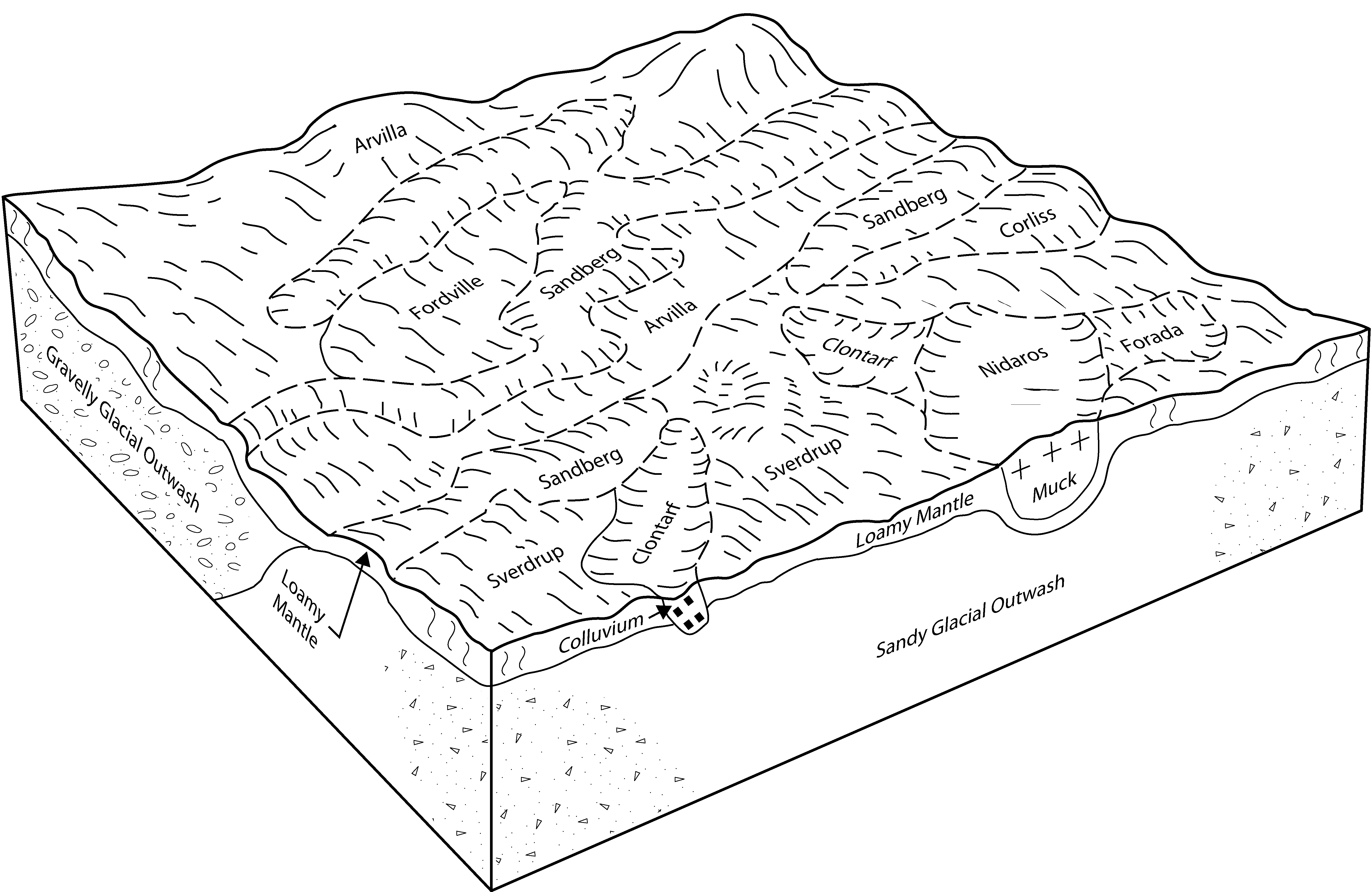
Sverdrup-Sandberg complex, 2 to 6 percent slopes | 1221B | 3488 | 435569 | gm7m | mn111 | 1996 | 1:20000 |
Sandberg-Sverdrup complex, 6 to 12 percent slopes | 1219C | 3276 | 435568 | gm7l | mn111 | 1996 | 1:20000 |
Sandberg sandy loam, 2 to 12 percent slopes | 258C | 3150 | 3026323 | 2w8fq | mn111 | 1996 | 1:20000 |
Sandberg loamy sand, 2 to 12 percent slopes | D8C | 907 | 3026322 | 2w8fm | mn111 | 1996 | 1:20000 |
Arvilla-Sandberg complex, 2 to 6 percent slopes | 711B | 843 | 435905 | gmlg | mn111 | 1996 | 1:20000 |
Sandberg loamy coarse sand, 6 to 30 percent slopes | D8E | 721 | 3026341 | 2w8fn | mn111 | 1996 | 1:20000 |
Sandberg-Radium complex, 0 to 6 percent slopes | I57B | 218 | 2799138 | prpd | mn111 | 1996 | 1:20000 |
Sandberg gravelly sandy loam, 6 to 30 percent slopes | 258E | 106 | 3026340 | 2w8fr | mn111 | 1996 | 1:20000 |
Radium-Sandberg-Garborg complex, 0 to 2 percent slopes | I75A | 8499 | 2799220 | vx9x | mn113 | 2003 | 1:12000 |
Sandberg-Radium complex, 0 to 6 percent slopes | I57B | 475 | 2799203 | prpd | mn113 | 2003 | 1:12000 |
Sandberg-Buse-Everts complex, 12 to 40 percent slopes | J83F | 2510 | 780524 | v666 | mn117 | 2005 | 1:12000 |
Renshaw-Sandberg complex, 2 to 6 percent slopes | J72B | 1949 | 780517 | v65z | mn117 | 2005 | 1:12000 |
Arvilla-Sandberg complex, 2 to 6 percent slopes | J31B | 340 | 1149495 | 17l4h | mn117 | 2005 | 1:12000 |
Sandberg-Arvilla complex, 6 to 12 percent slopes | J42C | 113 | 1149519 | 17l58 | mn117 | 2005 | 1:12000 |
Sandberg sandy loam, 12 to 40 percent slopes | J45F | 24 | 1149525 | 17l5g | mn117 | 2005 | 1:12000 |
Sandberg-Radium complex, 0 to 6 percent slopes | I57B | 20487 | 2799675 | prpd | mn119 | 1996 | 1:20000 |
Sandberg loamy sand, 6 to 15 percent slopes | I681C | 2053 | 2799739 | 2sw8z | mn119 | 1996 | 1:20000 |
Sandberg loamy sand, 15 to 25 percent slopes | I681E | 1660 | 2799738 | 2sw8y | mn119 | 1996 | 1:20000 |
Sandberg sandy loam, 1 to 6 percent slopes | 258B | 938 | 352227 | 2w8fp | mn119 | 1996 | 1:20000 |
Sandberg sandy loam, 2 to 12 percent slopes | 258C | 217 | 352228 | 2w8fq | mn119 | 1996 | 1:20000 |
Sandberg gravelly sandy loam, 6 to 30 percent slopes | 258E | 46 | 352230 | 2w8fr | mn119 | 1996 | 1:20000 |
Radium-Sandberg-Garborg complex, 0 to 2 percent slopes | I75A | 33 | 2799687 | vx9x | mn119 | 1996 | 1:20000 |
Sandberg loamy sand, 1 to 6 percent slopes | D8B | 5821 | 3026304 | 2w8fl | mn121 | 1968 | 1:20000 |
Sandberg gravelly sandy loam, 6 to 30 percent slopes | 258E | 4250 | 3026342 | 2w8fr | mn121 | 1968 | 1:20000 |
Sandberg loamy coarse sand, 6 to 30 percent slopes | D8E | 3928 | 3026343 | 2w8fn | mn121 | 1968 | 1:20000 |
Sandberg loamy sand, 2 to 12 percent slopes | D8C | 3289 | 3026324 | 2w8fm | mn121 | 1968 | 1:20000 |
Sandberg sandy loam, 2 to 12 percent slopes | 258C | 1244 | 3026325 | 2w8fq | mn121 | 1968 | 1:20000 |
Sandberg sandy loam, 1 to 6 percent slopes | 258B | 1080 | 3026308 | 2w8fp | mn121 | 1968 | 1:20000 |
Sandberg-Radium complex, 0 to 6 percent slopes | I57B | 1657 | 2799804 | prpd | mn125 | 2001 | 1:12000 |
Radium-Sandberg-Garborg complex, 0 to 2 percent slopes | I75A | 0 | 2799834 | vx9x | mn135 | 1999 | 1:24000 |
Sandberg-Arvilla complex, 0 to 3 percent slopes | 1223 | 4925 | 431434 | ggy7 | mn141 | 1994 | 1:15840 |
Sandberg loamy sand, 1 to 6 percent slopes | 258B | 4817 | 431470 | 2w8fl | mn141 | 1994 | 1:15840 |
Sandberg loamy coarse sand, 6 to 30 percent slopes | 258E | 2388 | 431472 | 2w8fn | mn141 | 1994 | 1:15840 |
Sandberg loamy sand, 2 to 12 percent slopes | 258C | 1479 | 431471 | 2w8fm | mn141 | 1994 | 1:15840 |
Sandberg loamy sand, 2 to 12 percent slopes | 611C | 7285 | 428171 | 2w8fm | mn145 | 1980 | 1:15840 |
Sandberg loamy coarse sand, 6 to 30 percent slopes | 611D | 5801 | 428172 | 2w8fn | mn145 | 1980 | 1:15840 |
Sandberg sandy loam, 1 to 6 percent slopes | SsB | 3085 | 428375 | 2w8fp | mn149 | 1966 | 1:15840 |
Sandberg sandy loam, 2 to 12 percent slopes | SgC | 1157 | 428373 | 2w8fq | mn149 | 1966 | 1:15840 |
Sandberg-Radium complex, 0 to 6 percent slopes | I57B | 7 | 2799909 | prpd | mn149 | 1966 | 1:15840 |
Arvilla-Sandberg complex, 2 to 6 percent slopes | J31B | 5038 | 434811 | glg5 | mn151 | 2000 | 1:12000 |
Sandberg-Arvilla complex, 6 to 12 percent slopes | J42C | 1236 | 434827 | glgp | mn151 | 2000 | 1:12000 |
Sandberg gravelly sandy loam, 6 to 30 percent slopes | J45F | 336 | 434831 | 2w8fr | mn151 | 2000 | 1:12000 |
Sandberg loamy sand, 2 to 12 percent slopes | 402C | 717 | 428537 | 2w8fm | mn153 | 1985 | 1:20000 |
Sandberg loamy coarse sand, 6 to 30 percent slopes | 402E | 429 | 428538 | 2w8fn | mn153 | 1985 | 1:20000 |
Sandberg-Radium complex, 0 to 6 percent slopes | I57B | 10 | 2799990 | prpd | mn167 | 1985 | 1:20000 |
Sandberg-Arvilla complex, map >25, 0 to 3 percent slopes | 1223 | 1015 | 435046 | glpr | mn171 | 1998 | 1:12000 |
Sandberg loamy sand, 1 to 6 percent slopes | 258B | 294 | 433719 | 2w8fl | mn171 | 1998 | 1:12000 |
Sandberg loamy coarse sand, 6 to 30 percent slopes | 258E | 277 | 433715 | 2w8fn | mn171 | 1998 | 1:12000 |
Sandberg loamy sand, 2 to 12 percent slopes | 258C | 97 | 433718 | 2w8fm | mn171 | 1998 | 1:12000 |
Buse, moderately eroded-Sandberg complex, 12 to 18 percent slopes | J227D2 | 462 | 1481686 | 1lqtb | mn173 | 1979 | 1:20000 |
Arvilla-Sandberg complex, 2 to 6 percent slopes | J31B | 435 | 1481667 | 1lqsq | mn173 | 1979 | 1:20000 |
Buse-Sandberg complex, 18 to 40 percent slopes | J227F | 420 | 1481710 | 1lqv3 | mn173 | 1979 | 1:20000 |
Sandberg-Arvilla complex, 6 to 12 percent slopes | J42C | 360 | 1481678 | 1lqt2 | mn173 | 1979 | 1:20000 |
Sandberg sandy loam, 12 to 40 percent slopes | J45F | 131 | 1481700 | 1lqts | mn173 | 1979 | 1:20000 |
Arvilla-Sandberg sandy loams, coteau, 2 to 6 percent slopes | Z176B | 178 | 2765320 | 2rjd0 | sd011 | 1995 | 1:24000 |
Arvilla-Sandberg sandy loams, coteau, 2 to 6 percent slopes | Z176B | 118 | 2712990 | 2rjd0 | sd039 | 1992 | 1:20000 |
Arvilla-Sandberg sandy loams, coteau, 6 to 9 percent slopes | Z176C | 79 | 2712989 | 2rjcy | sd039 | 1992 | 1:20000 |
Arvilla-Sandberg sandy loams, coteau, 6 to 9 percent slopes | Z176C | 391 | 2712934 | 2rjcy | sd051 | 1977 | 1:20000 |
Arvilla-Sandberg sandy loams, coteau, 2 to 6 percent slopes | Z176B | 203 | 2712935 | 2rjd0 | sd051 | 1977 | 1:20000 |

