| Shubuta-Saffell complex, 10 to 30 percent slopes | SsE | 3964 | 328093 | c0dn | al001 | 1972 | 1:20000 |
Saffell gravelly fine sandy loam, 2 to 8 percent slopes | SaC | 3956 | 328092 | c0dm | al001 | 1972 | 1:20000 |
Saffell gravelly sandy loam, 5 to 15 percent slopes | SaD | 570 | 2233628 | 2dz8j | al007 | 2007 | 1:24000 |
Saffell very gravelly sandy loam, 6 to 10 percent slopes | SaC | 17184 | 328546 | 2y6xk | al021 | 1967 | 1:20000 |
Saffell gravelly sandy loam, 2 to 6 percent slopes | SaB | 11500 | 328545 | c0w7 | al021 | 1967 | 1:20000 |
Saffell gravelly sandy loam, 10 to 15 percent slopes | SaD | 4049 | 328547 | c0w9 | al021 | 1967 | 1:20000 |
Smithdale-Saffell complex, 15 to 45 percent slopes | SsF | 10140 | 600098 | n4g0 | al025 | 2004 | 1:24000 |
Saffell-Pikeville complex, 15 to 45 percent slopes | SaF | 59605 | 328707 | c11g | al033 | 1986 | 1:20000 |
Troup-Gritney-Saffell complex, 8 to 15 percent slopes | TgD | 33239 | 328743 | c12m | al035 | 1985 | 1:20000 |
Oktibbeha-Saffell complex, 5 to 25 percent slopes | OsE | 27479 | 328737 | c12f | al035 | 1985 | 1:20000 |
Saffell gravelly fine sandy loam, 4 to 12 percent slopes | 50 | 2990 | 329089 | c1fs | al047 | 1977 | 1:20000 |
Smithdale-Saffell-Luverne complex, gravelly, 8 to 40 percent slopes | SnF | 21002 | 3272036 | 2zkvr | al051 | 1948 | 1:20000 |
Saffell gravelly fine sandy loam, 2 to 5 percent slopes | SaB | 3232 | 329364 | c1qn | al053 | 1969 | 1:20000 |
Saffell gravelly fine sandy loam, 5 to 12 percent slopes | SaC | 2338 | 329365 | c1qp | al053 | 1969 | 1:20000 |
Saffell very gravelly fine sandy loam, 6 to 15 percent slopes | GnD | 725 | 329461 | 2xz8m | al057 | 1963 | 1:15840 |
Terrace escarpments | Tc | 180 | 329522 | c1wr | al057 | 1963 | 1:15840 |
Saffell very gravelly fine sandy loam, 6 to 15 percent slopes | GuD2 | 27027 | 329598 | 2xz8m | al059 | 1962 | 1:15840 |
Saffell gravelly fine sandy loam, 2 to 6 percent slopes | SaB | 1821 | 329596 | c1z4 | al059 | 1962 | 1:15840 |
Smithdale-Saffell complex, 15 to 35 percent slopes | SvE | 1250 | 2494838 | 2psg7 | al075 | 2010 | 1:24000 |
Saffell very gravelly fine sandy loam, 6 to 15 percent slopes | SaD | 946 | 2494560 | 2xz8m | al075 | 2010 | 1:24000 |
Saffell gravelly fine sandy loam, 2 to 6 percent slopes | SaB | 152 | 2494559 | 2psfy | al075 | 2010 | 1:24000 |
Saffell and Bodine soils, steep | SBF | 46045 | 523056 | kk8s | al077 | 1973 | 1:20000 |
Saffell gravelly fine sandy loam, 6 to 10 percent slopes | SaC | 10629 | 523057 | kk8t | al077 | 1973 | 1:20000 |
Saffell-Luverne complex, 15 to 35 percent slopes | SaE | 5153 | 2514621 | 2qcvn | al085 | 2011 | 1:24000 |
Saffell gravelly sandy loam, 2 to 8 percent slopes | SaC | 194 | 2520312 | 2qkgn | al085 | 2011 | 1:24000 |
Saffell very gravelly fine sandy loam, 6 to 15 percent slopes | 28 | 9600 | 330630 | 2xz8m | al093 | 1976 | 1:20000 |
Saffell-Lucy (flomaton) complex, 15 to 35 percent slopes | SgF | 103874 | 330857 | 2v5lp | al099 | 1984 | 1:20000 |
Saffell very gravelly sandy loam, 8 to 15 percent slopes | SfD | 42200 | 330856 | 2v5lq | al099 | 1984 | 1:20000 |
Saffell very gravelly sandy loam, 5 to 8 percent slopes | SfC | 4500 | 330855 | c38r | al099 | 1984 | 1:20000 |
Saffell gravelly sandy loam, 5 to 15 percent slopes | SaD | 6500 | 331250 | c3ph | al105 | 1996 | 1:24000 |
Saffell-Maubila complex, 2 to 5 percent slopes | SbB | 1580 | 331251 | c3pj | al105 | 1996 | 1:24000 |
Saffell-Smithdale-Luverne complex, 8 to 35 percent slopes | SaF | 36250 | 331672 | c443 | al131 | 1997 | 1:24000 |
Saffell gravelly fine sandy loam, 3 to 8 percent slopes, moderately eroded | SaC2 | 14528 | 565184 | 2ykhb | ar011 | 1959 | 1:20000 |
Saffell gravelly fine sandy loam, 3 to 8 percent slopes | SaC | 5103 | 565183 | 2tztc | ar011 | 1959 | 1:20000 |
Saffell gravelly fine sandy loam, sloping phase | SaD | 1460 | 565186 | lz3t | ar011 | 1959 | 1:20000 |
Saffell gravelly fine sandy loam, 8 to 12 percent slopes, moderately eroded | SaD2 | 1013 | 565187 | 2ykh9 | ar011 | 1959 | 1:20000 |
Saffell gravelly fine sandy loam, 12 to 25 percent slopes | SaE | 431 | 565188 | lz3w | ar011 | 1959 | 1:20000 |
Saffell gravelly fine sandy loam, 3 to 8 percent slopes, severely eroded | SaC3 | 401 | 565185 | 2ykh8 | ar011 | 1959 | 1:20000 |
Saffell gravelly fine sandy loam, 3 to 8 percent slopes | 64 | 10165 | 3179400 | 2tztc | ar019 | 1983 | 1:20000 |
Saffell-Sacul association, rolling | 66 | 8147 | 3179402 | lyp0 | ar019 | 1983 | 1:20000 |
Saffell gravelly fine sandy loam, 8 to 12 percent slopes | 65 | 2156 | 3179401 | lynz | ar019 | 1983 | 1:20000 |
Brandon-Saffell association, moderately steep | 18 | 21767 | 564050 | lxy5 | ar021 | 1975 | 1:20000 |
Saffell gravelly fine sandy loam, 3 to 8 percent slopes | SaC | 7896 | 565314 | 2tztc | ar025 | 1965 | 1:15840 |
Saffell gravelly fine sandy loam, 8 to 25 percent slopes | SaE | 2619 | 565315 | 2ykh4 | ar025 | 1965 | 1:15840 |
Brandon-Saffell association, moderately steep | 6 | 7010 | 564151 | ly1f | ar031 | 1976 | 1:20000 |
Brandon-Saffell association, moderately sloping | 5 | 1570 | 564150 | ly1d | ar031 | 1976 | 1:20000 |
Saffell gravelly fine sandy loam, 8 to 20 percent slopes | SfE | 1026 | 565475 | lzf4 | ar043 | 1972 | 1:24000 |
Saffell gravelly fine sandy loam, 3 to 8 percent slopes | SfC | 876 | 565474 | 2tztc | ar043 | 1972 | 1:24000 |
Saffell gravelly fine sandy loam, 1 to 8 percent slopes | 12C | 3887 | 1715895 | 2ykhf | ar053 | 2006 | 1:24000 |
Saffell gravelly fine sandy loam, 15 to 35 percent slopes | 12E | 3259 | 1715897 | 1vljj | ar053 | 2006 | 1:24000 |
Saffell gravelly fine sandy loam, 8 to 15 percent slopes | 12D | 1385 | 1715896 | 2ykh5 | ar053 | 2006 | 1:24000 |
Brandon-Saffell complex, 15 to 35 percent slopes | 4E | 31007 | 577956 | mddr | ar055 | 1995 | 1:24000 |
Brandon-Saffell complex, 8 to 15 percent slopes | 4D | 4484 | 577953 | mddn | ar055 | 1995 | 1:24000 |
Brandon-Saffell complex, 3 to 8 percent slopes | 4C | 2627 | 577955 | mddq | ar055 | 1995 | 1:24000 |
Saffell gravelly fine sandy loam, 3 to 8 percent slopes | 38 | 4597 | 565664 | 2tztc | ar057 | 1976 | 1:20000 |
Saffell gravelly fine sandy loam, 8 to 12 percent slopes | 39 | 4000 | 565665 | 2ykh6 | ar057 | 1976 | 1:20000 |
Oktibbeha-Saffell association, rolling | 29 | 3632 | 565654 | lzlx | ar057 | 1976 | 1:20000 |
Saffell-Sacul association, rolling | 66 | 24176 | 3179292 | lyp0 | ar059 | 1983 | 1:20000 |
Saffell gravelly fine sandy loam, 3 to 8 percent slopes | 64 | 15718 | 3179290 | 2tztc | ar059 | 1983 | 1:20000 |
Saffell gravelly fine sandy loam, 8 to 12 percent slopes | 65 | 3907 | 3179291 | lynz | ar059 | 1983 | 1:20000 |
Saffell gravelly sandy loam, 3 to 8 percent slopes | SeC | 19265 | 565714 | lznv | ar061 | 1970 | 1:24000 |
Saffell gravelly sandy loam, 8 to 20 percent slopes | SeE | 14463 | 565715 | lznw | ar061 | 1970 | 1:24000 |
Saffell gravelly sandy loam, 1 to 3 percent slopes | SeB | 2741 | 565713 | lznt | ar061 | 1970 | 1:24000 |
Saffell gravelly fine sandy loam, 12 to 20 percent slopes | 53 | 4510 | 565776 | lzqv | ar063 | 1980 | 1:20000 |
Saffell gravelly fine sandy loam, 8 to 12 percent slopes | 52 | 2852 | 565775 | lzqt | ar063 | 1980 | 1:20000 |
Saffell gravelly fine sandy loam, 8 to 15 percent slopes | SfD | 2710 | 721502 | 2ykh5 | ar099 | 2000 | 1:24000 |
Saffell gravelly fine sandy loam, 3 to 8 percent slopes | SfC | 1457 | 721501 | 2tztc | ar099 | 2000 | 1:24000 |
Saffell gravelly sandy loam, 3 to 10 percent slopes | SlC | 7205 | 566077 | m01k | ar103 | 1969 | 1:20000 |
Saffell gravelly sandy loam, 1 to 3 percent slopes | SlB | 1662 | 566076 | m01j | ar103 | 1969 | 1:20000 |
Brandon-Saffell complex, 12 to 20 percent slopes | BsE | 7789 | 564264 | ly52 | ar111 | 1973 | 1:20000 |
Saffell-Urban land complex, 3 to 8 percent slopes | SfC | 857 | 566202 | m05l | ar119 | 1972 | 1:20000 |
Saffell gravelly fine sandy loam, 3 to 8 percent slopes | 18 | 5904 | 566225 | 2tztc | ar125 | 1976 | 1:20000 |
Saffell-Urban land complex, 3 to 8 percent slopes | 19 | 2232 | 566226 | m06c | ar125 | 1976 | 1:20000 |
Saffell gravelly fine sandy loam, 3 to 8 percent slopes | 65 | 4544 | 564942 | lyvy | ar670 | 1981 | 1:20000 |
Saffell gravelly fine sandy loam, 1 to 3 percent slopes | 64 | 2750 | 564941 | lyvx | ar670 | 1981 | 1:20000 |
Saffell gravelly fine sandy loam, 8 to 12 percent slopes | 66 | 986 | 564943 | 2ykh6 | ar670 | 1981 | 1:20000 |
Brandon-Saffell complex, 18 to 25 percent slopes, eroded | 956E2 | 2895 | 808061 | w3vh | il127 | 2004 | 1:12000 |
Brandon-Saffell complex, 10 to 18 percent slopes, eroded | 956D2 | 2334 | 808059 | w3vf | il127 | 2004 | 1:12000 |
Brandon-Saffell complex, 10 to 18 percent slopes, severely eroded | 956D3 | 1702 | 808060 | w3vg | il127 | 2004 | 1:12000 |
Brandon-Saffell complex, 10 to 18 percent slopes | 956D | 1034 | 808058 | w3vd | il127 | 2004 | 1:12000 |
Brandon-Saffell complex, 25 to 35 percent slopes | 956F | 731 | 808062 | w3vj | il127 | 2004 | 1:12000 |
Brandon-Saffell complex, 5 to 10 percent slopes, eroded | 956C2 | 256 | 808056 | w3vb | il127 | 2004 | 1:12000 |
Brandon-Saffell complex, 2 to 5 percent slopes | 956B | 212 | 808055 | w3v9 | il127 | 2004 | 1:12000 |
Brandon-Saffell complex, 5 to 10 percent slopes, severely eroded | 956C3 | 57 | 808057 | w3vc | il127 | 2004 | 1:12000 |
Brandon-Saffell complex, 18 to 25 percent slopes, eroded | 956E2 | 1096 | 608150 | ndtr | il151 | 2003 | 1:12000 |
Brandon-Saffell complex, 10 to 18 percent slopes, eroded | 956D2 | 1037 | 608148 | ndtp | il151 | 2003 | 1:12000 |
Brandon-Saffell complex, 10 to 18 percent slopes | 956D | 902 | 608147 | ndtn | il151 | 2003 | 1:12000 |
Brandon-Saffell complex, 10 to 18 percent slopes, severely eroded | 956D3 | 670 | 608149 | ndtq | il151 | 2003 | 1:12000 |
Brandon-Saffell complex, 25 to 35 percent slopes | 956F | 395 | 608151 | ndts | il151 | 2003 | 1:12000 |
Brandon-Saffell complex, 5 to 10 percent slopes, severely eroded | 956C3 | 237 | 637249 | pd3f | il151 | 2003 | 1:12000 |
Brandon-Saffell complex, 5 to 10 percent slopes, eroded | 956C2 | 212 | 608166 | ndv8 | il151 | 2003 | 1:12000 |
Brandon-Saffell complex, 2 to 5 percent slopes | 956B | 50 | 608164 | ndv6 | il151 | 2003 | 1:12000 |
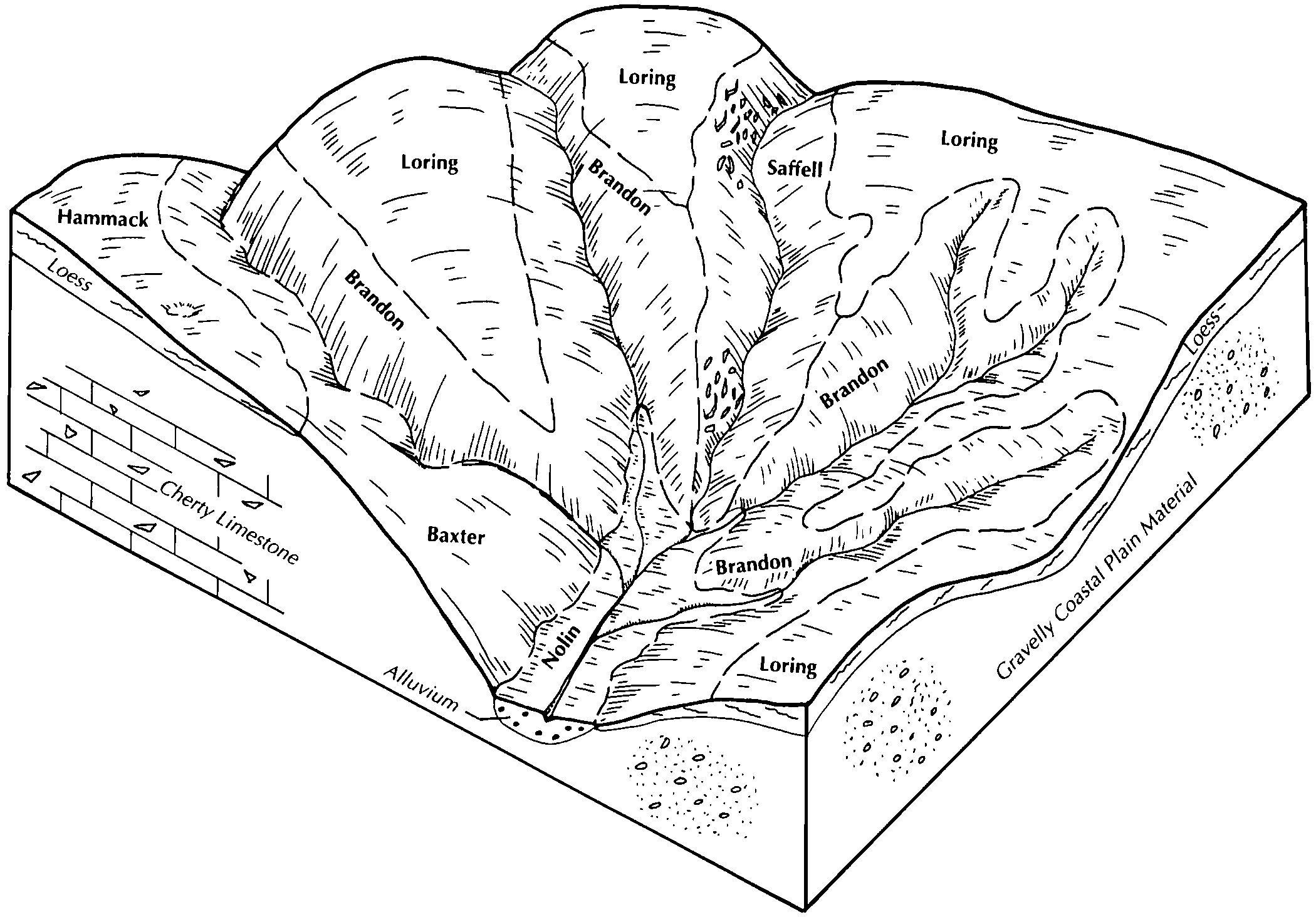
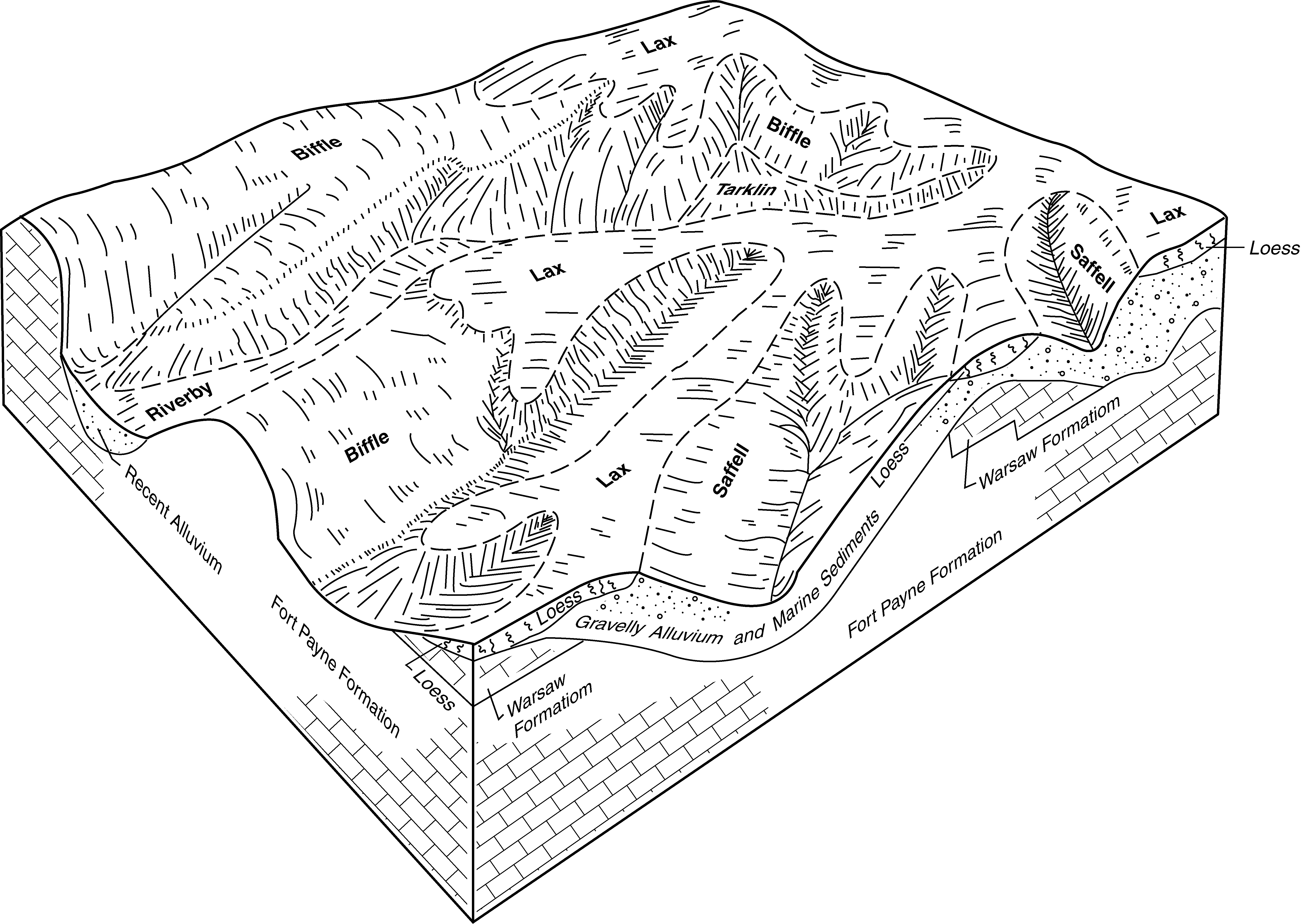
Brandon-Saffell-Smithdale complex, 20 to 35 percent slopes, eroded | BnE2 | 14822 | 570619 | 2wn5f | ky083 | 1995 | 1:12000 |
Smithdale-Saffell complex, 35 to 55 percent slopes, eroded | SsE2 | 433 | 570651 | m4t3 | ky083 | 1995 | 1:12000 |
Saffell gravelly sandy loam, 2 to 10 percent slopes | SaC | 127 | 570649 | m4t1 | ky083 | 1995 | 1:12000 |
Saffell gravelly silt loam, 20 to 40 percent slopes | SaE | 2868 | 549356 | lfn5 | ky139 | 1989 | 1:20000 |
Brandon-Saffell-Smithdale complex, 20 to 35 percent slopes, eroded | BnE2 | 3714 | 1592732 | 2wn5f | ky602 | 1972 | 1:12000 |
Saffell gravelly sandy loam, 2 to 10 percent slopes | SaC | 305 | 1592699 | 1qgbd | ky602 | 1972 | 1:12000 |
Brandon-Saffell-Smithdale complex, 20 to 35 percent slopes, eroded | BsE2 | 12052 | 2232584 | 2wn5f | ky610 | 1968 | 1:12000 |
Saffell-Smithdale-Brandon complex, 20 to 60 percent slopes | SsF | 10214 | 2232592 | 2dy63 | ky610 | 1968 | 1:12000 |
Saffell-Smithdale-Brandon complex, 20 to 60 percent slopes, severely eroded | SsF3 | 7061 | 2623441 | 2qykg | ky610 | 1968 | 1:12000 |
Saffell-Brandon complex, 12 to 25 percent slopes, eroded | SbD2 | 3176 | 2232598 | 2dy69 | ky610 | 1968 | 1:12000 |
Saffell gravelly sandy loam, 2 to 12 percent slopes | SaC | 1049 | 2232597 | 2dy68 | ky610 | 1968 | 1:12000 |
Saffell-Brandon-Smithdale complex, 6 to 12 percent slopes, severely eroded | SbC3 | 69 | 2232591 | 2dy62 | ky610 | 1968 | 1:12000 |
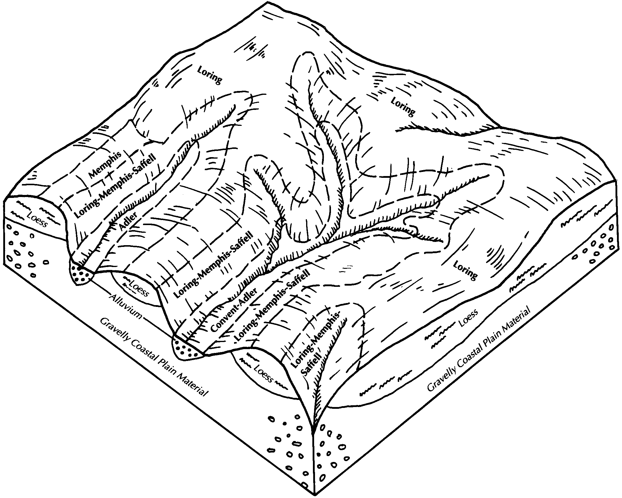
Loring-Memphis-Saffell complex, 12 to 30 percent slopes, severely eroded | LsE3 | 21831 | 570533 | m4p9 | ky611 | 1991 | 1:20000 |
Brandon-Saffell complex, 20 to 50 percent slopes | BxE | 41548 | 549451 | lfr7 | ky629 | 1979 | 1:20000 |
Saffell very gravelly silt loam, 20 to 60 percent slopes | SgF | 6550 | 549495 | lfsn | ky629 | 1979 | 1:20000 |
Saffell very gravelly silt loam, 6 to 12 percent slopes | SgC | 480 | 549494 | lfsm | ky629 | 1979 | 1:20000 |
Saffell gravelly loam, 15 to 45 percent slopes | 90020 | 974 | 995602 | 12f06 | mo201 | 1978 | 1:24000 |
Saffell gravelly sandy loam, 12 to 30 percent slopes | SaE | 14015 | 567457 | m1h2 | ms005 | 1971 | 1:20000 |
Saffell gravelly sandy loam, 8 to 12 percent slopes | SaD | 1555 | 567456 | m1h1 | ms005 | 1971 | 1:20000 |
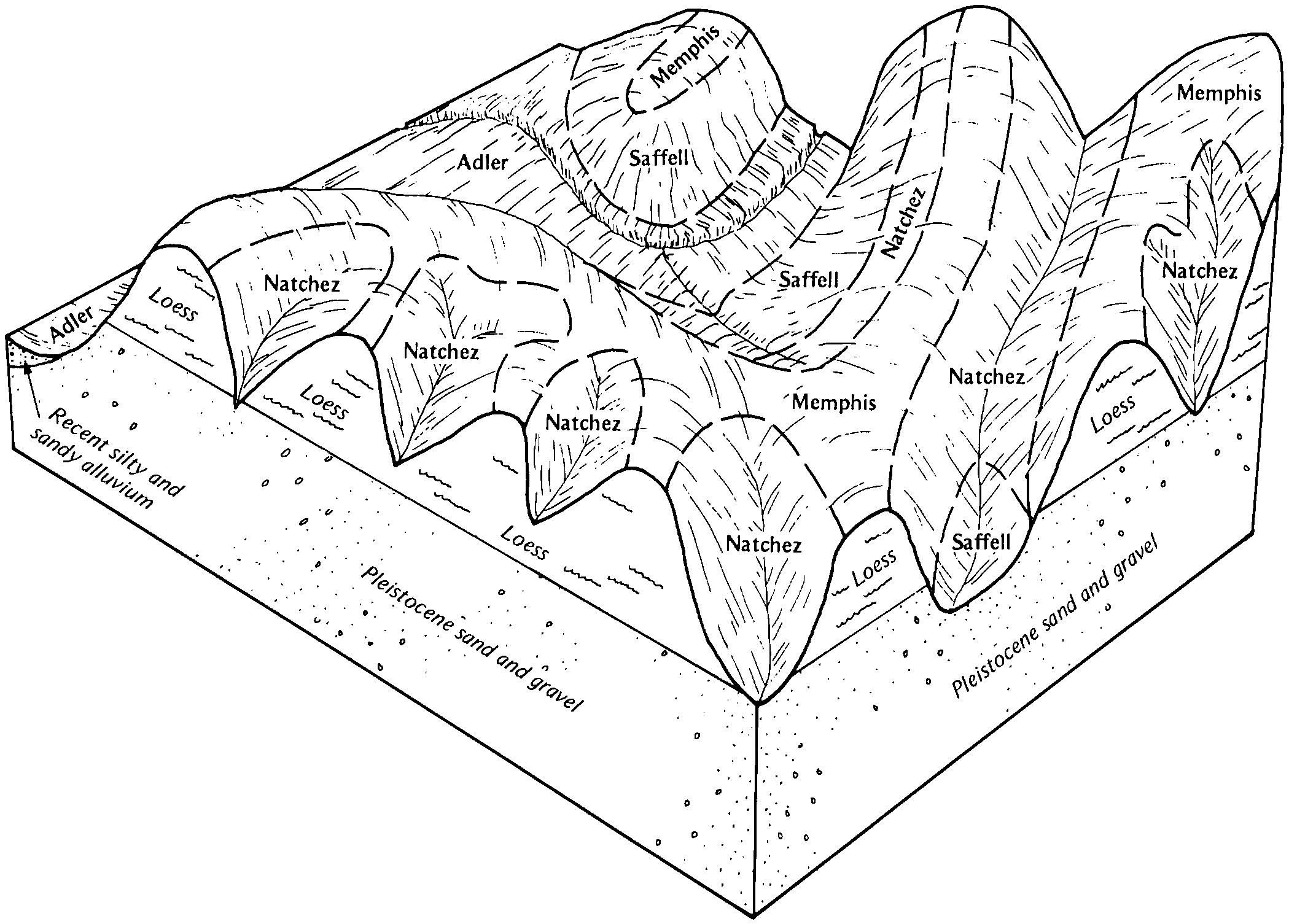
Natchez-Saffell association, hilly | 60F1 | 3254 | 567556 | m1l8 | ms015 | 1985 | 1:20000 |
Saffell gravelly sandy loam, 17 to 40 percent slopes | SaF | 10843 | 567705 | m1r2 | ms029 | 1981 | 1:20000 |
Saffell-Smithdale association, hilly | SF | 5300 | 567702 | m1qz | ms029 | 1981 | 1:20000 |
Saffell gravelly sandy loam, 12 to 17 percent slopes | SaE | 4144 | 567704 | m1r1 | ms029 | 1981 | 1:20000 |
Guin gravelly sandy loam, 12 to 40 percent slopes (saffell) | GgF | 298 | 332141 | c4m7 | ms031 | 1962 | 1:15840 |
Guin and Saffell gravelly sandy loams, 2 to 8 percent slopes (saffell) | GsC | 225 | 332142 | c4m8 | ms031 | 1962 | 1:15840 |
Guin gravelly sandy loam, 8 to 12 percent slopes (saffell) | GgD | 71 | 332140 | c4m6 | ms031 | 1962 | 1:15840 |
Saffell gravelly sandy loam, 15 to 40 percent slopes | 72F1 | 19355 | 567821 | m1vt | ms037 | 1992 | 1:20000 |
Saffell-Natchez complex, 12 to 50 percent slopes | Sf | 1955 | 567990 | m218 | ms051 | 1997 | 1:20000 |
Saffell gravelly sandy loam, 2 to 8 percent slopes | SaC | 765 | 567989 | m217 | ms051 | 1997 | 1:20000 |
Saffell gravelly sandy loam, 8 to 45 percent slopes | SaF | 383 | 332483 | c4z8 | ms057 | 1975 | 1:20000 |
Saffell gravelly sandy loam, 2 to 8 percent slopes | SaC | 592 | 332692 | c560 | ms065 | 1972 | 1:20000 |
Saffell gravelly sandy loam, 12 to 17 percent slopes | SaE | 2370 | 332942 | c5g2 | ms077 | 1972 | 1:20000 |
Saffell gravelly sandy loam, 2 to 5 percent slopes | SaB | 597 | 332941 | c5g1 | ms077 | 1972 | 1:20000 |
Smithdale-Saffell complex, 15 to 35 percent slopes | SnF | 5781 | 333100 | c5m5 | ms087 | 1977 | 1:20000 |
Smithdale-Saffell association, hilly | SR | 2538 | 333093 | c5ly | ms087 | 1977 | 1:20000 |
Smithdale-Saffell-Lucy association, hilly | SS | 12752 | 333137 | c5nc | ms091 | 1983 | 1:20000 |
Saffell gravelly sandy loam, 8 to 40 percent slopes | SaF | 1601 | 333138 | c5nd | ms091 | 1983 | 1:20000 |
Saffell very gravelly fine sandy loam, 6 to 15 percent slopes | GsD | 668 | 333169 | 2xz8m | ms095 | 1963 | 1:15840 |
Memphis, Natchez, and Guin soils, 17 to 40 percent slopes, eroded (memphis, natchez, saffell) | MnF2 | 7258 | 568343 | m2dn | ms107 | 1961 | 1:24000 |
Saffell gravelly fine sandy loam, 17 to 35 percent slopes | SaF | 7442 | 333667 | c66g | ms113 | 1965 | 1:15840 |
Saffell gravelly fine sandy loam, 8 to 17 percent slopes | SaE | 3281 | 333666 | c66f | ms113 | 1965 | 1:15840 |
Saffell gravelly fine sandy loam, 5 to 8 percent slopes | SaC | 350 | 333665 | c66d | ms113 | 1965 | 1:15840 |
Saffell-Smithdale association, hilly | SA | 27431 | 334243 | c6t1 | ms141 | 1980 | 1:20000 |
Saffell loam, 15 to 25 percent slopes | 69 | 7 | 1715951 | 1vll8 | ms143 | 2006 | 1:24000 |
Saffell gravelly fine sandy loam, 2 to 8 percent slopes, eroded | SaC2 | 541 | 334326 | c6wq | ms147 | 1965 | 1:20000 |
Saffell gravelly fine sandy loam, 8 to 12 percent slopes, eroded | SaD2 | 284 | 334327 | c6wr | ms147 | 1965 | 1:20000 |
Saffell gravelly sandy loam, 15 to 40 percent slopes, severely eroded | 26F3 | 3022 | 571055 | m574 | ms157 | 2006 | 1:24000 |
Saffell gravelly fine sandy loam, 1 to 5 percent slopes | 63 | 828 | 571380 | m5km | ok005 | 1977 | 1:24000 |
Saffell gravelly fine sandy loam, 3 to 8 percent slopes | 45 | 716 | 571237 | m5f0 | ok023 | 1977 | 1:24000 |
Saffell gravelly fine sandy loam, 5 to 12 percent slopes | SeE | 21210 | 571180 | m5c5 | ok089 | 1970 | 1:24000 |
Saffell gravelly fine sandy loam, 1 to 5 percent slopes | SeC | 3239 | 571179 | m5c4 | ok089 | 1970 | 1:24000 |
Saffell gravelly sandy loam, 5 to 20 percent slopes | 45 | 6510 | 571298 | m5gz | ok127 | 1977 | 1:24000 |
Saffell gravelly sandy loam, 3 to 5 percent slopes | 44 | 1737 | 571297 | m5gy | ok127 | 1977 | 1:24000 |
Saffell-Brandon complex, 12 to 25 percent slopes, eroded | SaE2 | 1428 | 2545381 | 2qshc | tn005 | 2011 | 1:12000 |
Saffell-Brandon complex, 5 to 12 percent slopes, eroded | SaC2 | 171 | 2545382 | 2qshd | tn005 | 2011 | 1:12000 |
Saffell, Smithdale, and Brandon soils, 25 to 60 percent slopes | SAF | 37 | 2545380 | 2qshb | tn005 | 2011 | 1:12000 |
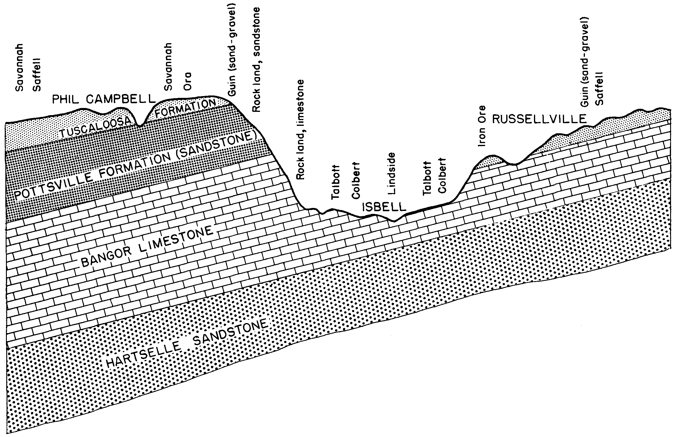
SAFFELL GRAVELLY SILT LOAM, HILLY PHASE | Ef | 1097 | 327302 | bzl4 | tn039 | 2008 | 1:24000 |
SAFFELL GRAVELLY SILT LOAM, STEEP PHASE | Eh | 641 | 327304 | bzl6 | tn039 | 2008 | 1:24000 |
SAFFELL GRAVELLY SILT LOAM, SEVERELY ERODED HILLY PHASE | Eg | 358 | 327303 | bzl5 | tn039 | 2008 | 1:24000 |
SAFFELL GRAVELLY SILT LOAM, ERODED HILLY PHASE | Ee | 212 | 327301 | bzl3 | tn039 | 2008 | 1:24000 |
ROUGH GULLIED LAND, SAFFELL, AND LEXINGTON SOILS | Rd | 170 | 327346 | bzmk | tn039 | 2008 | 1:24000 |
Saffell gravelly fine sandy loam, 20 to 60 percent slopes | SaF | 8162 | 527124 | kpj0 | tn043 | 1993 | 1:24000 |
Saffell gravelly fine sandy loam, 12 to 20 percent slopes | SaD | 5635 | 527123 | kphz | tn043 | 1993 | 1:24000 |
Waynesboro very gravelly sandy loam, 25 to 45 percent slopes (Saffell) | WnF | 11188 | 327681 | bzzc | tn071 | 1961 | 1:15840 |
Waynesboro gravelly sandy loam, 12 to 25 percent slopes (Saffell) | WmE | 6744 | 327678 | bzz8 | tn071 | 1961 | 1:15840 |
Bodine-Guin complex, 20 to 35 percent slopes (Bodine-Saffell) | BeF | 6065 | 327518 | bzt3 | tn071 | 1961 | 1:15840 |
Waynesboro gravelly sandy loam, 5 to 8 percent slopes (Saffell) | WmC | 5809 | 327676 | bzz6 | tn071 | 1961 | 1:15840 |
Waynesboro gravelly sandy loam, 8 to 12 percent slopes (Saffell) | WmD | 2516 | 327677 | bzz7 | tn071 | 1961 | 1:15840 |
Waynesboro very gravelly sandy loam, 12 to 25 percent slopes (Saffell) | WnE | 2202 | 327680 | bzzb | tn071 | 1961 | 1:15840 |
Waynesboro very gravelly sandy loam, 5 to 12 percent slopes (Saffell) | WnD | 1683 | 327679 | bzz9 | tn071 | 1961 | 1:15840 |
Saffell gravelly sandy loam, 5 to 12 percent slopes | SaD | 604 | 327625 | bzxk | tn071 | 1961 | 1:15840 |
Saffell gravelly sandy loam, 12 to 20 percent slopes | SaE | 371 | 327626 | bzxl | tn071 | 1961 | 1:15840 |
Saffell-Brandon complex, 12 to 25 percent slopes, eroded | SaE2 | 7491 | 2545301 | 2qs9g | tn079 | 2012 | 1:12000 |
Saffell, Smithdale, and Brandon soils, 25 to 60 percent slopes | SAF | 5884 | 2545300 | 2qs9f | tn079 | 2012 | 1:12000 |
Saffell-Brandon complex, 5 to 12 percent slopes, eroded | SaC2 | 1216 | 2545302 | 2qs9h | tn079 | 2012 | 1:12000 |
Saffell gravelly fine sandy loam, 20 to 60 percent slopes | SaF | 108 | 527486 | kpwp | tn081 | 1997 | 1:24000 |
Saffell gravelly fine sandy loam, 12 to 20 percent slopes | SaD | 19 | 527485 | kpwn | tn081 | 1997 | 1:24000 |
Saffell gravelly silt loam, 12 to 20 percent slopes | SaD | 379 | 530881 | ktf6 | tn101 | 1999 | 1:24000 |
Saffell gravelly silt loam, 20 to 40 percent slopes | SaE | 74 | 530882 | ktf7 | tn101 | 1999 | 1:24000 |
Saffell gravelly sandy loam, 12 to 30 percent slopes | SaE | 2424 | 327979 | c08z | tn109 | 1994 | 1:20000 |
Saffell gravelly sandy loam, 5 to 12 percent slopes | SaC | 1229 | 327978 | c08y | tn109 | 1994 | 1:20000 |
Saffell-Bodine complex, 20 to 40 percent slopes | SbE | 29988 | 3160445 | 1kyyt | tn161 | 1953 | 1:20000 |
Saffell-Bodine complex, 40 to 70 percent slopes | SbF | 5864 | 3160446 | 1kyyx | tn161 | 1953 | 1:20000 |
Saffell-Bodine complex, 12 to 20 percent slopes | SbD | 5284 | 3160457 | 1ttwy | tn161 | 1953 | 1:20000 |
Brandon-Saffell complex, 20 to 50 percent slopes | BxE | 482 | 3160469 | 2z6xs | tn161 | 1953 | 1:20000 |
Saffell gravelly silt loam, 20 to 60 percent slopes | Ge | 406 | 2396910 | 2lg5p | tn161 | 1953 | 1:20000 |
Saffell-Gullied land complex, 12 to 20 percent slopes | Re | 177 | 2396962 | 2lg7c | tn161 | 1953 | 1:20000 |
Saffell gravelly silt loam, 5 to 20 percent slopes | Gd | 177 | 2396909 | 2lg5n | tn161 | 1953 | 1:20000 |
Saffell gravelly fine sandy loam, 20 to 60 percent slopes | SaF | 29547 | 328042 | c0c0 | tn181 | 1996 | 1:24000 |
Saffell gravelly fine sandy loam, 12 to 20 percent slopes | SaD | 7036 | 328041 | c0bz | tn181 | 1996 | 1:24000 |
Saffell gravelly sandy loam, 3 to 8 percent slopes | 33 | 2367 | 575279 | m9md | tx037 | 1978 | 1:20000 |
Saffell-Urban land complex, 3 to 8 percent slopes | 34 | 186 | 575280 | m9mf | tx037 | 1978 | 1:20000 |


