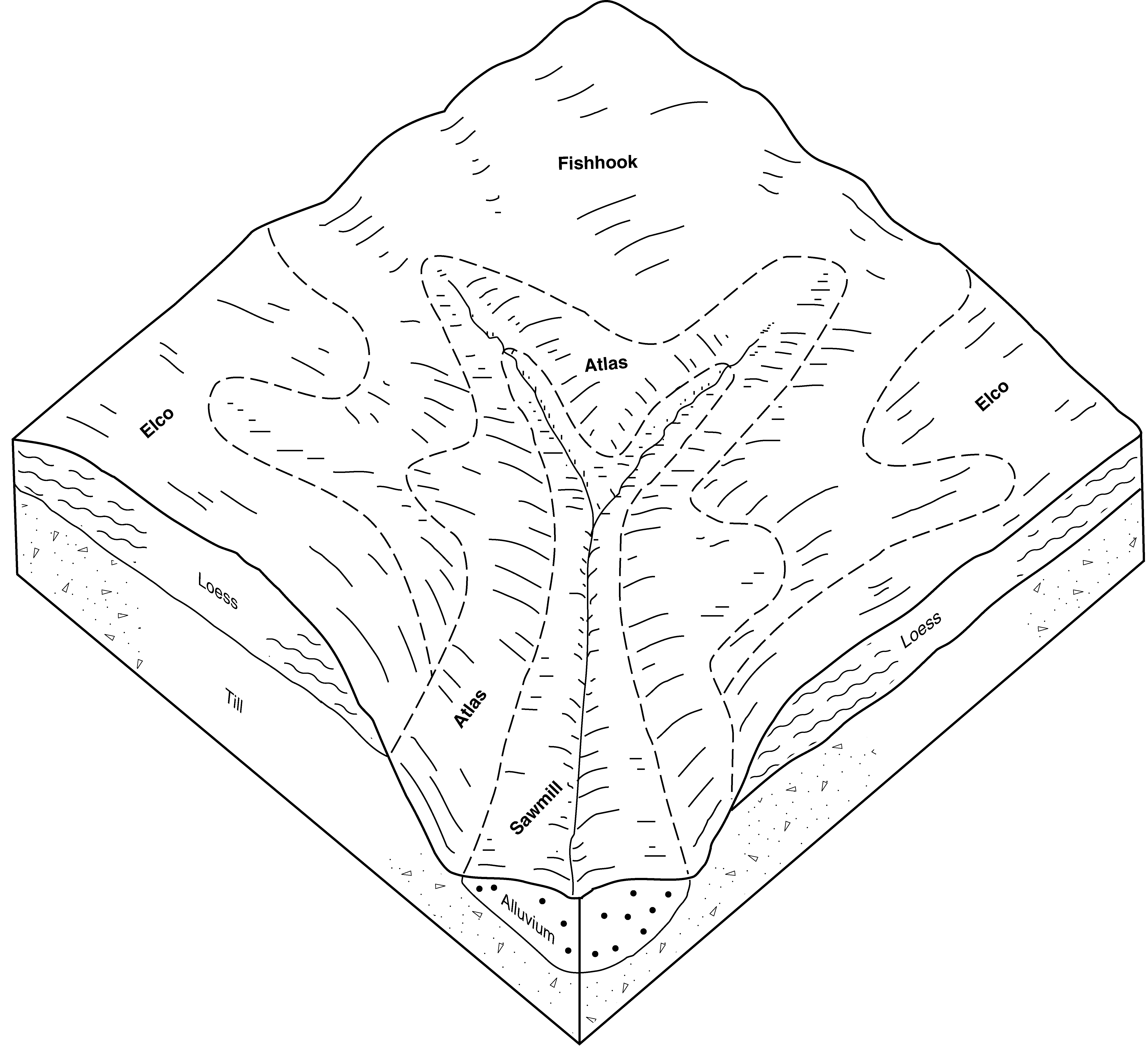
| Sawmill silty clay loam, shallow loess, 0 to 2 percent slopes, occasionally flooded | 933 | 8894 | 413283 | 2wm7m | ia013 | 2001 | 1:12000 |
Sawmill, occasionally flooded-Urban land complex, 0 to 2 percent slopes | 4933 | 101 | 413327 | 2wm7p | ia013 | 2001 | 1:12000 |
Sawmill silty clay loam, shallow loess, 0 to 2 percent slopes, occasionally flooded | 933 | 9106 | 404473 | 2wm7m | ia045 | 1978 | 1:15840 |
Sawmill silty clay loam, shallow loess, 1 to 4 percent slopes, occasionally flooded | 933B | 4710 | 405097 | 2wm7n | ia055 | 1984 | 1:15840 |
Sawmill silty clay loam, shallow loess, 0 to 2 percent slopes, occasionally flooded | 933 | 3191 | 404966 | 2wm7m | ia069 | 1977 | 1:15840 |
Sawmill silty clay loam, shallow loess, 0 to 2 percent slopes, occasionally flooded | 933 | 3626 | 406326 | 2wm7m | ia075 | 1973 | 1:15840 |
Sawmill silty clay loam, shallow loess, 0 to 2 percent slopes, occasionally flooded | 933 | 1090 | 406707 | 2wm7m | ia083 | 1982 | 1:15840 |
Sawmill silty clay loam, shallow loess, 0 to 2 percent slopes, occasionally flooded | 933 | 7672 | 408223 | 2wm7m | ia105 | 1988 | 1:15840 |
Sawmill silty clay loam, shallow loess, 1 to 4 percent slopes, occasionally flooded | 933B | 3864 | 411570 | 2wm7n | ia171 | 1989 | 1:15840 |
Sawmill silty clay loam, 0 to 2 percent slopes, frequently flooded | 3107A | 515 | 1394624 | 2w1z2 | il007 | 2006 | 1:12000 |
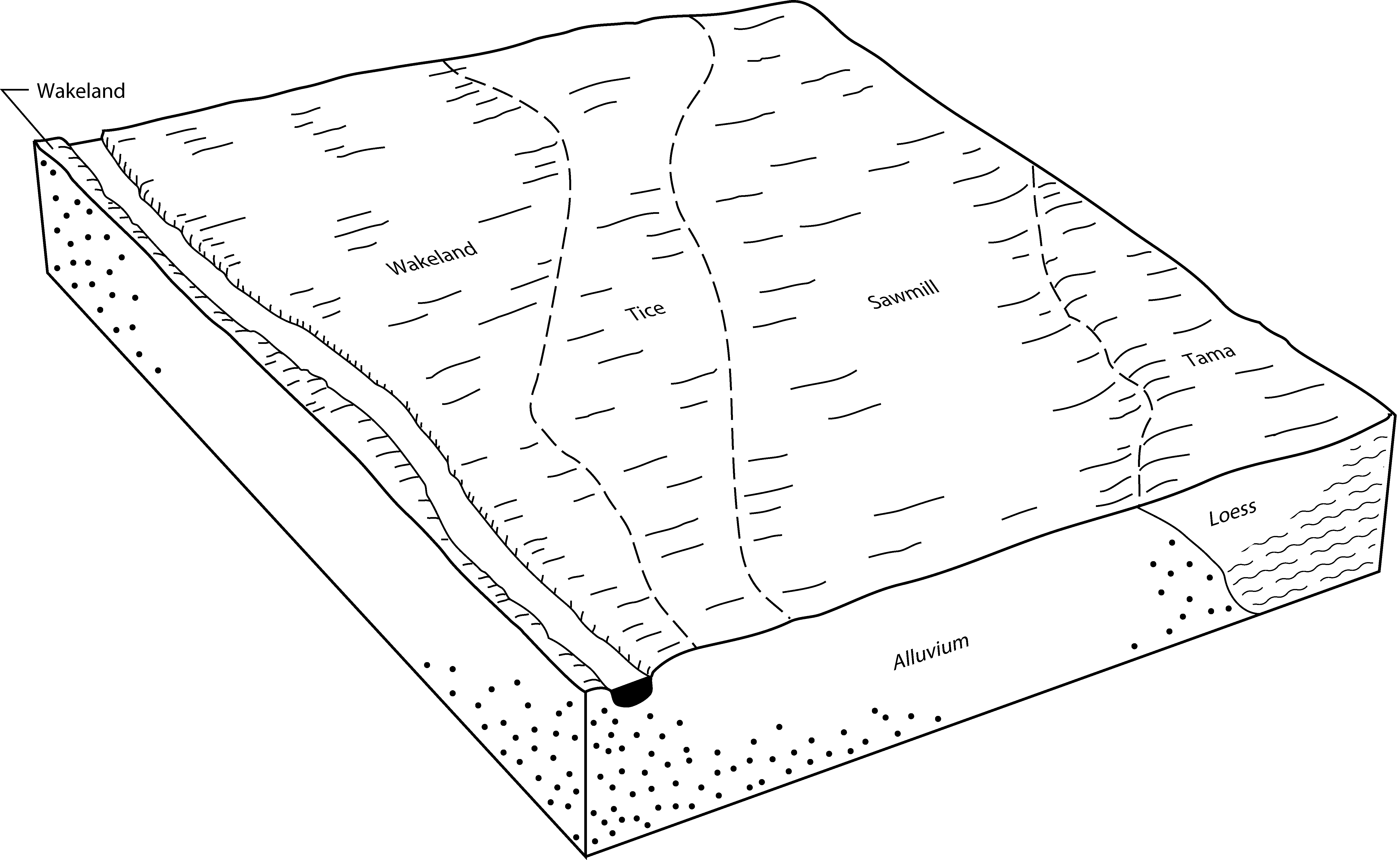
Sawmill silt loam, 0 to 2 percent slopes, occasionally flooded, overwash | 8107A+ | 16745 | 1910046 | 2w1z7 | il011 | 2007 | 1:12000 |
Sawmill silty clay loam, 0 to 2 percent slopes, occasionally flooded | 8107A | 40 | 2650854 | 2w1z6 | il011 | 2007 | 1:12000 |
Sawmill silty clay loam, 0 to 2 percent slopes, frequently flooded | 3107A | 7 | 1862902 | 2w1z2 | il011 | 2007 | 1:12000 |
Sawmill silty clay loam, 0 to 2 percent slopes, frequently flooded | 3107A | 1441 | 796092 | 2w1z2 | il015 | 2005 | 1:12000 |
Sawmill silty clay loam, 0 to 2 percent slopes, rarely flooded | 7107A | 1196 | 1543515 | 2w1z8 | il015 | 2005 | 1:12000 |
Sawmill silt loam, 0 to 2 percent slopes, frequently flooded, overwash | 3107A+ | 943 | 796093 | 2w1z3 | il015 | 2005 | 1:12000 |
Sawmill silty clay loam, undrained, 0 to 2 percent slopes, frequently flooded | 1107A | 537 | 796095 | 2w1zb | il015 | 2005 | 1:12000 |
Sawmill silt loam, 0 to 2 percent slopes, rarely flooded, overwash | 7107A+ | 185 | 1542855 | 2w1z9 | il015 | 2005 | 1:12000 |
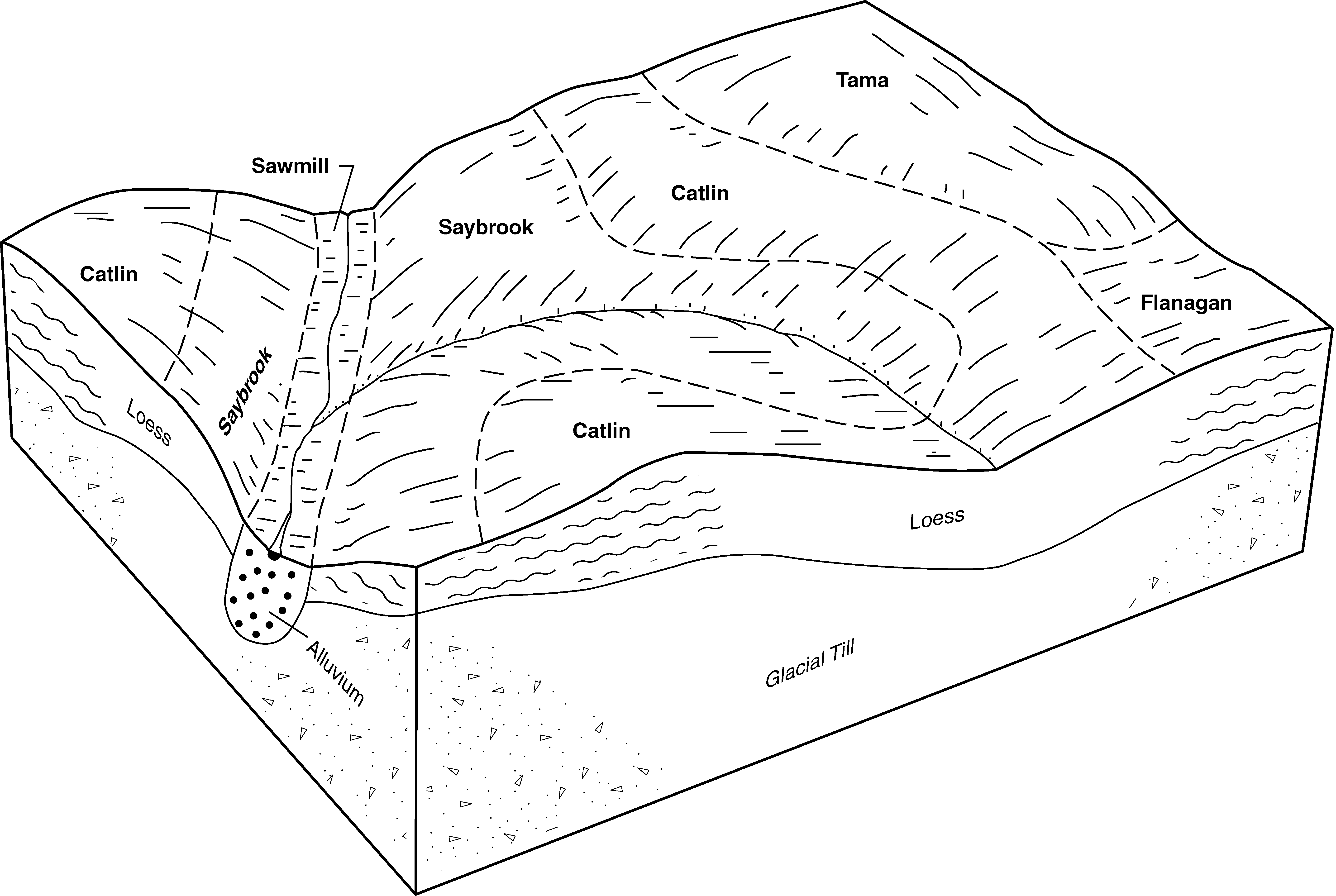
Sawmill silty clay loam, 0 to 2 percent slopes, frequently flooded, long duration | 3107L | 3818 | 1444860 | 2w1z5 | il017 | 2003 | 1:12000 |
Sawmill silty clay loam, 0 to 2 percent slopes, occasionally flooded | 8107A | 1173 | 262838 | 2w1z6 | il017 | 2003 | 1:12000 |
Sawmill silty clay loam, 0 to 2 percent slopes, rarely flooded | 7107A | 522 | 1445191 | 2w1z8 | il017 | 2003 | 1:12000 |
Sawmill silty clay loam, 0 to 2 percent slopes, frequently flooded | 3107A | 463 | 1444858 | 2w1z2 | il017 | 2003 | 1:12000 |
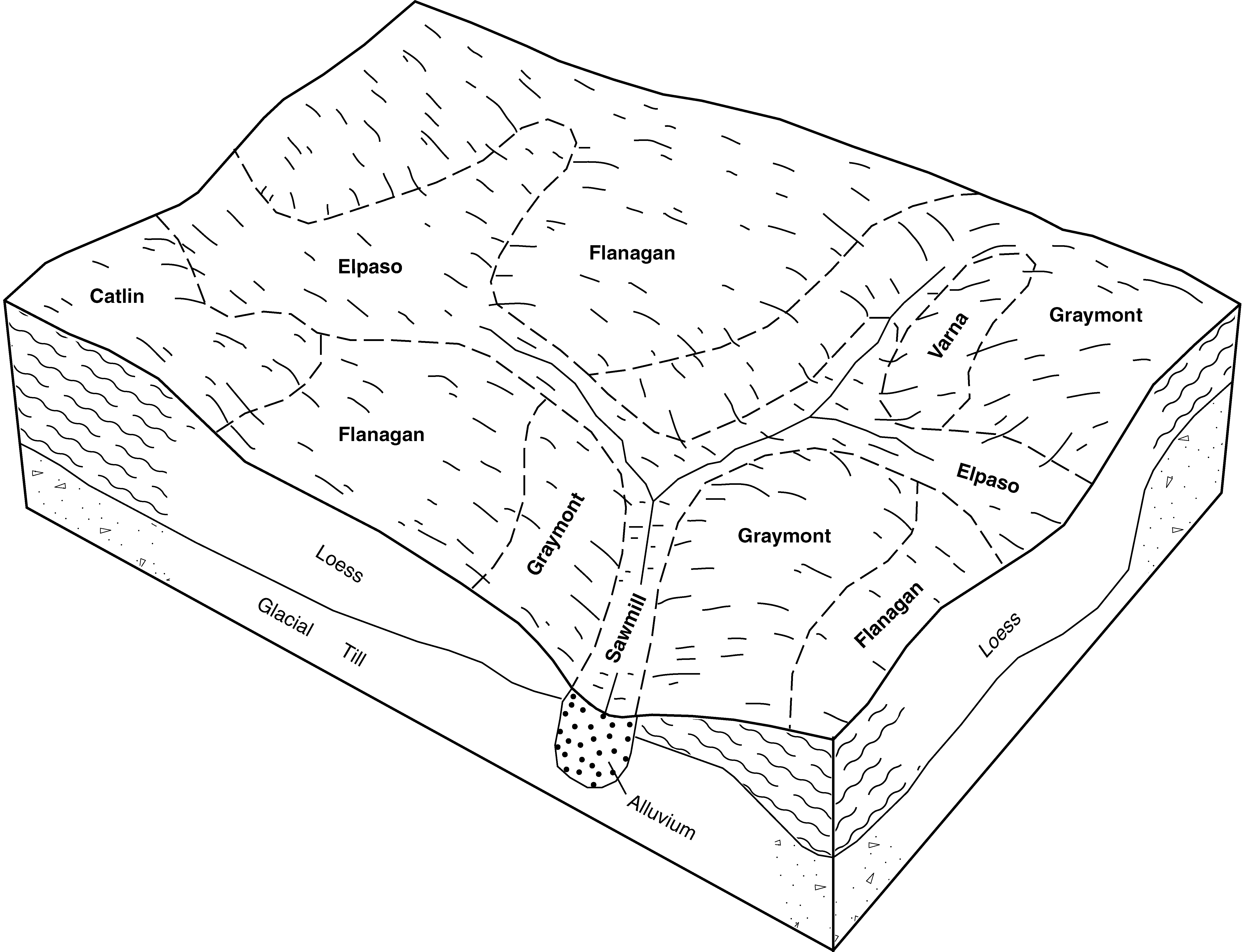
Sawmill silty clay loam, 0 to 2 percent slopes, frequently flooded | 3107A | 11073 | 243001 | 2w1z2 | il019 | 1999 | 1:12000 |
Sawmill silty clay loam, 0 to 2 percent slopes, frequently flooded | 3107A | 11000 | 261764 | 2w1z2 | il021 | 1999 | 1:12000 |
Sawmill silty clay loam, 0 to 2 percent slopes, frequently flooded | 3107A | 1685 | 1428416 | 2w1z2 | il029 | 2005 | 1:12000 |
Sawmill silty clay loam, heavy till plain, 0 to 2 percent slopes, frequently flooded | 3107A | 7031 | 2108708 | 2ww9j | il031 | 2008 | 1:12000 |
Sawmill silty clay loam, undrained, cool, 0 to 2 percent slopes, frequently flooded | 1107A | 1715 | 2108920 | 2ytdl | il031 | 2008 | 1:12000 |
Sawmill silty clay loam, 0 to 2 percent slopes, frequently flooded | 3107A | 4721 | 1592501 | 2w1z2 | il039 | 2005 | 1:12000 |
Sawmill silty clay loam, 0 to 2 percent slopes, occasionally flooded | 8107A | 1029 | 1592500 | 2w1z6 | il039 | 2005 | 1:12000 |
Sawmill silty clay loam, undrained, 0 to 2 percent slopes, frequently flooded | 1107A | 5405 | 200233 | 2ytdk | il041 | 2004 | 1:12000 |
Sawmill silty clay loam, 0 to 2 percent slopes, frequently flooded | 3107A | 1151 | 166414 | 2w1z2 | il041 | 2004 | 1:12000 |
Sawmill silty clay loam, heavy till plain, 0 to 2 percent slopes, frequently flooded | 3107A | 4875 | 183395 | 2ww9j | il043 | 1998 | 1:12000 |
Sawmill silty clay loam, undrained, cool, 0 to 2 percent slopes, frequently flooded | 1107A | 1060 | 183342 | 2ytdl | il043 | 1998 | 1:12000 |
Sawmill silty clay loam, 0 to 2 percent slopes, frequently flooded | 3107 | 10 | 173392 | 2w1z2 | il051 | 1991 | 1:15840 |
Sawmill silty clay loam, 0 to 2 percent slopes, frequently flooded | 3107A | 2778 | 198347 | 2w1z2 | il053 | 2001 | 1:12000 |
Sawmill silty clay loam, 0 to 2 percent slopes, frequently flooded | 3107A | 3701 | 615690 | 2w1z2 | il057 | 1997 | 1:12000 |
Sawmill silty clay loam, warm mesic, 0 to 2 percent slopes, occasionally flooded | 8107wA | 437 | 211581 | 2yp4m | il059 | 1966 | 1:20000 |
Sawmill silty clay loam, 0 to 2 percent slopes, occasionally flooded | 8107A | 3292 | 1596535 | 2w1z6 | il063 | 2005 | 1:12000 |
Sawmill silty clay loam, heavy till plain, 0 to 2 percent slopes, frequently flooded | 3107A | 3077 | 1143968 | 2ww9j | il063 | 2005 | 1:12000 |
Sawmill silty clay loam, undrained, cool, 0 to 2 percent slopes, frequently flooded | 1107A | 867 | 1144036 | 2ytdl | il063 | 2005 | 1:12000 |
Sawmill mucky silt loam, ponded, 0 to 2 percent slopes, frequently flooded | 4107A | 686 | 1590357 | 1qcwv | il063 | 2005 | 1:12000 |
Sawmill silty clay loam, 0 to 2 percent slopes, frequently flooded | 3107A | 3816 | 175178 | 2w1z2 | il067 | 1993 | 1:15840 |
Sawmill silty clay loam, 0 to 2 percent slopes, occasionally flooded | 8107A | 1521 | 175224 | 2w1z6 | il067 | 1993 | 1:15840 |
Sawmill silty clay loam, 0 to 2 percent slopes, frequently flooded | 3107A | 3275 | 632713 | 2w1z2 | il071 | 2005 | 1:12000 |
Sawmill silty clay loam, 0 to 2 percent slopes, rarely flooded | 7107A | 1645 | 1018052 | 2w1z8 | il071 | 2005 | 1:12000 |
Sawmill silty clay loam, undrained, 0 to 2 percent slopes, frequently flooded | 1107A | 949 | 1003079 | 2w1zb | il071 | 2005 | 1:12000 |
Sawmill silt loam, 0 to 2 percent slopes, frequently flooded, overwash | 3107A+ | 478 | 1480513 | 2w1z3 | il071 | 2005 | 1:12000 |
Sawmill silt loam, 0 to 2 percent slopes, frequently flooded, overwash | 3107A+ | 14193 | 244848 | 2w1z3 | il073 | 2001 | 1:12000 |
Sawmill silty clay loam, 0 to 2 percent slopes, frequently flooded | 3107A | 7509 | 244849 | 2w1z2 | il073 | 2001 | 1:12000 |
Sawmill silt loam, 0 to 2 percent slopes, occasionally flooded, overwash | 8107A+ | 823 | 244861 | 2w1z7 | il073 | 2001 | 1:12000 |
Sawmill silty clay loam, heavy till plain, 0 to 2 percent slopes, frequently flooded | 3107A | 8475 | 175539 | 2ww9j | il075 | 1980 | 1:15840 |
Sawmill silty clay loam, 0 to 2 percent slopes, frequently flooded | 3107A | 26 | 728465 | 2w1z2 | il083 | 2002 | 1:12000 |
Sawmill silty clay loam, undrained, cool, 0 to 2 percent slopes, frequently flooded | 1107A | 2 | 271594 | 2ytdl | il089 | 2000 | 1:12000 |
Sawmill silty clay loam, heavy till plain, 0 to 2 percent slopes, frequently flooded | 3107A | 4732 | 968591 | 2ww9j | il091 | 2003 | 1:12000 |
Sawmill silty clay loam, heavy till plain, 0 to 2 percent slopes, frequently flooded | 3107A | 2474 | 1715628 | 2ww9j | il093 | 2007 | 1:12000 |
Sawmill silt loam, 0 to 2 percent slopes, frequently flooded, overwash | 3107A+ | 6140 | 680873 | 2w1z3 | il095 | 2002 | 1:12000 |
Sawmill silty clay loam, undrained, cool, 0 to 2 percent slopes, frequently flooded | 1107A | 4395 | 804227 | 2ytdl | il097 | 2003 | 1:12000 |
Sawmill silty clay loam, heavy till plain, 0 to 2 percent slopes, frequently flooded | 3107A | 275 | 804207 | 2ww9j | il097 | 2003 | 1:12000 |
Sawmill silty clay loam, heavy till plain, 0 to 2 percent slopes, frequently flooded | 3107A | 2973 | 1427836 | 2ww9j | il099 | 2006 | 1:12000 |
Sawmill silty clay loam, 0 to 2 percent slopes, occasionally flooded | 8107A | 1244 | 1386853 | 2w1z6 | il099 | 2006 | 1:12000 |
Sawmill silty clay loam, warm mesic, 0 to 2 percent slopes, occasionally flooded | 8107wA | 2217 | 176762 | 2yp4m | il101 | 1952 | 1:42240 |
Sawmill silt loam, overwash, occasionally flooded | 8107+ | 63 | 176763 | 5xy1 | il101 | 1952 | 1:42240 |
Sawmill silty clay loam, heavy till plain, 0 to 2 percent slopes, frequently flooded | 3107A | 6906 | 176962 | 2ww9j | il105 | 1991 | 1:15840 |
Sawmill silty clay loam, 0 to 2 percent slopes, frequently flooded | 3107A | 14675 | 208703 | 2w1z2 | il107 | 2006 | 1:12000 |
Sawmill silty clay loam, 0 to 2 percent slopes, occasionally flooded | 8107A | 3297 | 1595800 | 2w1z6 | il107 | 2006 | 1:12000 |
Sawmill silt loam, 0 to 2 percent slopes, frequently flooded, overwash | 3107A+ | 3276 | 1595801 | 2w1z3 | il107 | 2006 | 1:12000 |
Sawmill silty clay loam, sandy substratum, 0 to 2 percent slopes, frequently flooded | 3107AS | 2586 | 1596115 | 2w1z4 | il107 | 2006 | 1:12000 |
Sawmill silt loam, 0 to 2 percent slopes, occasionally flooded, overwash | 8107A+ | 830 | 1690961 | 2w1z7 | il107 | 2006 | 1:12000 |
Sawmill silty clay loam, 0 to 2 percent slopes, frequently flooded | 3107A | 5032 | 634097 | 2w1z2 | il109 | 2002 | 1:12000 |
Sawmill silty clay loam, 0 to 2 percent slopes, occasionally flooded | 8107A | 16647 | 199148 | 2w1z6 | il113 | 2000 | 1:12000 |
Sawmill silty clay loam, 0 to 2 percent slopes, frequently flooded | 3107A | 491 | 195766 | 2w1z2 | il113 | 2000 | 1:12000 |
Sawmill silty clay loam, 0 to 2 percent slopes, frequently flooded | 3107A | 9911 | 1913982 | 2w1z2 | il115 | 2007 | 1:12000 |
Sawmill silty clay loam, undrained, 0 to 2 percent slopes, frequently flooded | 1107A | 546 | 1913978 | 2ytdk | il115 | 2007 | 1:12000 |
Sawmill silty clay loam, 0 to 2 percent slopes, frequently flooded | 3107A | 1964 | 199248 | 2w1z2 | il117 | 1999 | 1:12000 |
Sawmill silty clay loam, 0 to 2 percent slopes, occasionally flooded | 8107A | 6746 | 182242 | 2w1z6 | il123 | 1997 | 1:15840 |
Sawmill silty clay loam, 0 to 2 percent slopes, occasionally flooded | 8107A | 4337 | 177819 | 2w1z6 | il125 | 1989 | 1:15840 |
Sawmill silty clay loam, 0 to 2 percent slopes, frequently flooded | 3107A | 1981 | 177784 | 2w1z2 | il125 | 1989 | 1:15840 |
Sawmill silty clay loam, sandy substratum, 0 to 2 percent slopes, frequently flooded | 3107AS | 1302 | 2517982 | 2w1z4 | il125 | 1989 | 1:15840 |
Sawmill silt loam, 0 to 2 percent slopes, occasionally flooded, overwash | 8107A+ | 744 | 177820 | 2w1z7 | il125 | 1989 | 1:15840 |
Sawmill silty clay loam, 0 to 2 percent slopes, frequently flooded, long duration | 3107L | 346 | 2517981 | 2w1z5 | il125 | 1989 | 1:15840 |
Sawmill silt loam, 0 to 2 percent slopes, frequently flooded, overwash | 3107A+ | 175 | 177785 | 2w1z3 | il125 | 1989 | 1:15840 |
Sawmill silty clay loam, sandy substratum, 0 to 2 percent slopes, frequently flooded | 3107AS | 2211 | 1412349 | 2w1z4 | il129 | 2005 | 1:12000 |
Sawmill silty clay loam, 0 to 2 percent slopes, frequently flooded | 3107A | 953 | 1406383 | 2w1z2 | il129 | 2005 | 1:12000 |
Sawmill silty clay loam, 0 to 2 percent slopes, frequently flooded, long duration | 3107L | 19 | 1406384 | 2w1z5 | il129 | 2005 | 1:12000 |
Sawmill silty clay loam, 0 to 2 percent slopes, frequently flooded | 3107A | 4997 | 245022 | 2w1z2 | il131 | 2000 | 1:12000 |
Sawmill silt loam, 0 to 2 percent slopes, frequently flooded, overwash | 3107A+ | 4645 | 245021 | 2w1z3 | il131 | 2000 | 1:12000 |
Sawmill silty clay loam, 0 to 2 percent slopes, rarely flooded | 7107A | 765 | 245027 | 2w1z8 | il131 | 2000 | 1:12000 |
Sawmill silty clay loam, 0 to 2 percent slopes, frequently flooded | 3107A | 306 | 1721541 | 2w1z2 | il135 | 2007 | 1:12000 |
Sawmill silty clay loam, 0 to 2 percent slopes, frequently flooded | 3107A | 1060 | 1672110 | 2w1z2 | il137 | 1984 | 1:15840 |
Sawmill silty clay loam, 0 to 2 percent slopes, frequently flooded | 3107A | 2426 | 246534 | 2w1z2 | il139 | 1999 | 1:12000 |
Sawmill silty clay loam, undrained, 0 to 2 percent slopes, frequently flooded | 1107A | 1190 | 246515 | 2ytdk | il139 | 1999 | 1:12000 |
Sawmill silty clay loam, 0 to 2 percent slopes, frequently flooded | 3107A | 3143 | 1144348 | 2w1z2 | il141 | 2005 | 1:12000 |
Sawmill silty clay loam, 0 to 2 percent slopes, frequently flooded | 3107A | 1616 | 208950 | 2w1z2 | il143 | 1986 | 1:15840 |
Sawmill silty clay loam, 0 to 2 percent slopes, frequently flooded | 3107A | 7363 | 1912403 | 2w1z2 | il147 | 2009 | 1:12000 |
Sawmill silty clay loam, 0 to 2 percent slopes, occasionally flooded | 8107A | 2143 | 172893 | 2w1z6 | il155 | 1987 | 1:15840 |
Sawmill silty clay loam, undrained, 0 to 2 percent slopes, occasionally flooded | 1107A | 1245 | 172863 | 2w1zc | il155 | 1987 | 1:15840 |
Sawmill silty clay loam, 0 to 2 percent slopes, frequently flooded | 3107A | 7052 | 198694 | 2w1z2 | il161 | 2002 | 1:12000 |
Sawmill silty clay loam, 0 to 2 percent slopes, rarely flooded | 7107A | 4107 | 198702 | 2w1z8 | il161 | 2002 | 1:12000 |
Sawmill silty clay loam, undrained, 0 to 2 percent slopes, frequently flooded | 1107A | 1389 | 198688 | 2w1zb | il161 | 2002 | 1:12000 |
Sawmill silt loam, 0 to 2 percent slopes, occasionally flooded, overwash | 8107A+ | 734 | 198709 | 2w1z7 | il161 | 2002 | 1:12000 |
Sawmill silty clay loam, 0 to 2 percent slopes, frequently flooded | 3107A | 12537 | 199294 | 2w1z2 | il167 | 1999 | 1:12000 |
Sawmill silty clay loam, 0 to 2 percent slopes, frequently flooded | 3107A | 63 | 202229 | 2w1z2 | il169 | 2000 | 1:12000 |
Sawmill silty clay loam, 0 to 2 percent slopes, frequently flooded | 3107A | 403 | 2542087 | 2w1z2 | il171 | 1984 | 1:12000 |
Sawmill silty clay loam, 0 to 2 percent slopes, frequently flooded | 3107 | 4195 | 179019 | 2w1z2 | il173 | 1990 | 1:15840 |
Sawmill silt loam, 0 to 2 percent slopes, occasionally flooded, overwash | 8107A+ | 1736 | 2542393 | 2w1z7 | il175 | 1992 | 1:15840 |
Sawmill silt loam, 0 to 2 percent slopes, frequently flooded, overwash | 3107A+ | 967 | 179090 | 2w1z3 | il175 | 1992 | 1:15840 |
Sawmill silty clay loam, 0 to 2 percent slopes, frequently flooded | 3107A | 88 | 179089 | 2w1z2 | il175 | 1992 | 1:15840 |
Sawmill silty clay loam, 0 to 2 percent slopes, frequently flooded | 3107A | 3636 | 1709788 | 2w1z2 | il177 | 2006 | 1:12000 |
Sawmill silty clay loam, undrained, 0 to 2 percent slopes, frequently flooded | 1107A | 2109 | 1592078 | 2w1zb | il177 | 2006 | 1:12000 |
Sawmill silty clay loam, 0 to 2 percent slopes, frequently flooded | 3107A | 6270 | 179398 | 2w1z2 | il179 | 1991 | 1:15840 |
Sawmill silty clay loam, 0 to 2 percent slopes, occasionally flooded | 8107A | 1202 | 2508837 | 2w1z6 | il179 | 1991 | 1:15840 |
Sawmill silty clay loam, 0 to 2 percent slopes, frequently flooded | 3107A | 5931 | 1601116 | 2w1z2 | il183 | 2006 | 1:12000 |
Sawmill silt loam, 0 to 2 percent slopes, frequently flooded, overwash | 3107A+ | 2655 | 244930 | 2w1z3 | il187 | 2002 | 1:12000 |
Sawmill silty clay loam, 0 to 2 percent slopes, frequently flooded | 3107A | 2122 | 244931 | 2w1z2 | il187 | 2002 | 1:12000 |
Sawmill silt loam, 0 to 2 percent slopes, occasionally flooded, overwash | 8107A+ | 2394 | 793141 | 2w1z7 | il195 | 2003 | 1:12000 |
Sawmill silty clay loam, 0 to 2 percent slopes, rarely flooded | 7107A | 986 | 793129 | 2w1z8 | il195 | 2003 | 1:12000 |
Sawmill silty clay loam, undrained, 0 to 2 percent slopes, frequently flooded | 1107A | 830 | 793104 | 2w1zb | il195 | 2003 | 1:12000 |
Sawmill silty clay loam, 0 to 2 percent slopes, frequently flooded | 3107A | 502 | 793113 | 2w1z2 | il195 | 2003 | 1:12000 |
Sawmill silty clay loam, heavy till plain, 0 to 2 percent slopes, frequently flooded | 3107A | 1831 | 618753 | 2ww9j | il197 | 2002 | 1:12000 |
Sawmill silty clay loam, 0 to 2 percent slopes, frequently flooded | 3107A | 2758 | 174216 | 2w1z2 | il201 | 1997 | 1:12000 |
Sawmill silty clay loam, 0 to 2 percent slopes, occasionally flooded | 8107A | 5906 | 869251 | 2w1z6 | il203 | 2008 | 1:12000 |
Sawmill silty clay loam, shallow loess, 0 to 2 percent slopes, occasionally flooded | 467 | 1564 | 400465 | 2wm7m | mn099 | 1986 | 1:15840 |
Sawmill silty clay loam | 467 | 2294 | 400779 | fg1c | mn109 | 1977 | 1:15840 |
Sawmill silt loam, calcareous variant | 7107A | 209 | 3268708 | g79p | wi059 | 2023 | 1:15840 |
Sawmill silt loam, calcareous variant | 7107A | 262 | 3403366 | g96f | wi079 | 2023 | 1:15840 |
Sawmill silt loam, calcareous variant | 7107A | 371 | 3268817 | g79p | wi101 | 2023 | 1:15840 |
Sawmill silt loam, calcareous variant | 7107A | 719 | 3403474 | g96f | wi133 | 2023 | 1:15840 |
