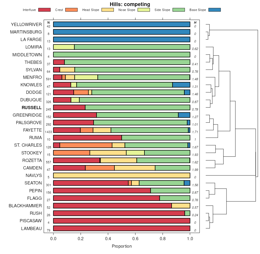
| Russell silt loam, 9 to 14 percent slopes, moderately eroded | 481D2 | 691 | 409991 | frmj | ia139 | 1986 | 1:15840 |
Russell silt loam, 14 to 18 percent slopes, moderately eroded | 481E2 | 258 | 409992 | frmk | ia139 | 1986 | 1:15840 |
Russell silt loam, Bloomington Ridged Plain, 5 to 10 percent slopes, eroded | 322C2 | 1931 | 242971 | 2t704 | il019 | 1999 | 1:12000 |
Russell silt loam, Bloomington Ridged Plain, 5 to 10 percent slopes, eroded | 322C2 | 4411 | 1428401 | 2t704 | il029 | 2005 | 1:12000 |
Russell silt loam, Bloomington Ridged Plain, 2 to 5 percent slopes | 322B | 1737 | 1428400 | 2t702 | il029 | 2005 | 1:12000 |
Russell silt loam, Bloomington Ridged Plain, 5 to 10 percent slopes, eroded | 322C2 | 38 | 174816 | 2t704 | il035 | 1992 | 1:15840 |
Russell silt loam, Bloomington Ridged Plain, 5 to 10 percent slopes, eroded | 322C2 | 6780 | 869327 | 2t704 | il039 | 2005 | 1:12000 |
Russell silty clay loam, 10 to 18 percent slopes, severely eroded | 322D3 | 654 | 1538134 | 1nmk7 | il039 | 2005 | 1:12000 |
Russell silt loam, Bloomington Ridged Plain, 5 to 10 percent slopes, eroded | 322C2 | 1477 | 200211 | 2t704 | il041 | 2004 | 1:12000 |
Russell silt loam, Bloomington Ridged Plain, 2 to 5 percent slopes | 322B | 13065 | 843562 | 2t702 | il045 | 1997 | 1:12000 |
Russell silt loam, Bloomington Ridged Plain, 5 to 10 percent slopes, eroded | 322C2 | 3055 | 843563 | 2t704 | il045 | 1997 | 1:12000 |
Senachwine-Russell silt loams, 10 to 18 percent slopes, eroded | 736D2 | 1865 | 1596079 | 1qkvf | il107 | 2006 | 1:12000 |
Russell silt loam, Bloomington Ridged Plain, 2 to 5 percent slopes, eroded | 322B2 | 1749 | 199114 | 2t703 | il113 | 2000 | 1:12000 |
Russell silt loam, Bloomington Ridged Plain, 5 to 10 percent slopes, eroded | 322C2 | 1748 | 199115 | 2t704 | il113 | 2000 | 1:12000 |
Russell silt loam, Bloomington Ridged Plain, 5 to 10 percent slopes, eroded | 322C2 | 4556 | 1913953 | 2t704 | il115 | 2007 | 1:12000 |
Russell silt loam, Bloomington Ridged Plain, 2 to 5 percent slopes | 322B | 2690 | 1910908 | 2t702 | il147 | 2009 | 1:12000 |
Russell silt loam, Bloomington Ridged Plain, 5 to 10 percent slopes, eroded | 322C2 | 2259 | 1910909 | 2t704 | il147 | 2009 | 1:12000 |
Russell silt loam, Bloomington Ridged Plain, 5 to 10 percent slopes, eroded | 322C2 | 6271 | 869205 | 2t704 | il203 | 2008 | 1:12000 |
Russell silt loam, 10 to 18 percent slopes, eroded | 322D2 | 1371 | 869206 | y5gx | il203 | 2008 | 1:12000 |
Russell silt loam, 2 to 6 percent slopes, eroded | RywB2 | 662 | 200907 | 2vzcj | in005 | 2002 | 1:12000 |
Urban land-Fincastle-Russell complex, 2 to 6 percent slopes | UfyB | 158 | 208346 | 6zsv | in005 | 2002 | 1:12000 |
Russell silt loam, 2 to 6 percent slopes | RuB | 9324 | 162454 | 2w0vz | in017 | 1979 | 1:15840 |
Russell silt loam, 6 to 12 percent slopes | RuC | 909 | 162455 | 5g1h | in017 | 1979 | 1:15840 |
Russell silt loam, 2 to 6 percent slopes | RuB | 1227 | 162355 | 2w0vz | in023 | 1978 | 1:20000 |
Russell silt loam, 0 to 2 percent slopes | RuA | 2 | 3291277 | 5f0v | in023 | 1978 | 1:20000 |
Russell-Fincastle silt loams, 1 to 4 percent slopes | RxB | 161 | 1600675 | 1qqmp | in029 | 1979 | 1:15840 |
Russell silt loam, 2 to 6 percent slopes | RuB | 5870 | 162409 | 2w0vz | in031 | 1980 | 1:15840 |
Russell silt loam, 2 to 6 percent slopes, eroded | RsB2 | 20437 | 1612916 | 2vzcj | in041 | 1958 | 1:15840 |
Russell soils, 6 to 12 percent slopes, severely eroded | RtC3 | 9765 | 1612924 | 1r4ct | in041 | 1958 | 1:15840 |
Russell silt loam, 2 to 6 percent slopes | RsB1 | 8363 | 1612915 | 2w0vz | in041 | 1958 | 1:15840 |
Russell silt loam, 6 to 12 percent slopes, moderately eroded | RsC2 | 5057 | 1612918 | 1r4cm | in041 | 1958 | 1:15840 |
Russell and Miami silt loams, 2 to 6 percent slopes, moderately eroded | RuB2 | 3244 | 1612929 | 1r4cz | in041 | 1958 | 1:15840 |
Russell soils, 12 to 18 percent slopes, severely eroded | RtD3 | 2504 | 1612925 | 1r4cv | in041 | 1958 | 1:15840 |
Russell silt loam, 0 to 2 percent slopes | RsA | 1922 | 1612914 | 1r4ch | in041 | 1958 | 1:15840 |
Russell silt loam, 12 to 18 percent slopes, moderately eroded | RsD2 | 1697 | 1612920 | 1r4cp | in041 | 1958 | 1:15840 |
Russell silt loam, 18 to 25 percent slopes, slightly eroded | RsE1 | 1601 | 1612921 | 1r4cq | in041 | 1958 | 1:15840 |
Russell silt loam, 18 to 25 percent slopes, moderately eroded | RsE2 | 1075 | 1612922 | 1r4cr | in041 | 1958 | 1:15840 |
Russell and Miami soils, 6 to 12 percent slopes, severely eroded | RvC3 | 1040 | 1612933 | 1r4d3 | in041 | 1958 | 1:15840 |
Russell silt loam, 12 to 18 percent slopes, slightly eroded | RsD1 | 845 | 1612919 | 1r4cn | in041 | 1958 | 1:15840 |
Russell silt loam, 6 to 12 percent slopes, slightly eroded | RsC1 | 765 | 1612917 | 1r4cl | in041 | 1958 | 1:15840 |
Russell soils, 2 to 6 percent slopes, severely eroded | RtB3 | 693 | 1612923 | 1r4cs | in041 | 1958 | 1:15840 |
Russell soils, 18 to 25 percent slopes, severely eroded | RtE3 | 669 | 1612926 | 1r4cw | in041 | 1958 | 1:15840 |
Russell and Miami silt loams, 6 to 12 percent slopes, moderately eroded | RuC2 | 660 | 1612931 | 1r4d1 | in041 | 1958 | 1:15840 |
Russell and Miami silt loams, 2 to 6 percent slopes, slightly eroded | RuB1 | 551 | 1612928 | 1r4cy | in041 | 1958 | 1:15840 |
Russell and Miami soils, 2 to 6 percent slopes, severely eroded | RvB3 | 276 | 1612932 | 1r4d2 | in041 | 1958 | 1:15840 |
Russell and Miami silt loams, 0 to 2 percent slopes | RuA | 91 | 1612927 | 1r4cx | in041 | 1958 | 1:15840 |
Russell and Miami silt loams, 6 to 12 percent slopes, slightly eroded | RuC1 | 47 | 1612930 | 1r4d0 | in041 | 1958 | 1:15840 |
Russell silt loam, 2 to 6 percent slopes, eroded | RywB2 | 10426 | 242490 | 2vzcj | in045 | 1999 | 1:12000 |
Russell silt loam, 6 to 12 percent slopes, eroded | RywC2 | 5458 | 242491 | 84b9 | in045 | 1999 | 1:12000 |
Russell silt loam, 12 to 18 percent slopes, eroded | RywD2 | 1645 | 242492 | 84bb | in045 | 1999 | 1:12000 |
Russell-Strawn complex, 18 to 25 percent slopes | RzcE | 353 | 242551 | 84d7 | in045 | 1999 | 1:12000 |
Russell silt loam, 2 to 6 percent slopes, eroded | RuB2 | 6500 | 162303 | 2vzcj | in047 | 1984 | 1:15840 |
Russell silt loam, bedrock substratum, 2 to 6 percent slopes | RvB | 288 | 162305 | 5fwn | in047 | 1984 | 1:15840 |
Russell silt loam, bedrock substratum, 0 to 2 percent slopes | RvA | 247 | 162304 | 5fwm | in047 | 1984 | 1:15840 |
Russell silt loam, 2 to 6 percent slopes, eroded | RuB2 | 2186 | 161506 | 2vzcj | in063 | 1971 | 1:15840 |
Russell silt loam, 6 to 12 percent slopes, eroded | RuC2 | 442 | 161507 | 5f1x | in063 | 1971 | 1:15840 |
Russell silt loam, 2 to 6 percent slopes, eroded | RuB2 | 2976 | 161475 | 2vzcj | in067 | 1967 | 1:20000 |
Russell silt loam, 0 to 2 percent slopes | RuA | 2909 | 161474 | 5f0v | in067 | 1967 | 1:20000 |
Russell silt loam, 2 to 6 percent slopes, eroded | RywB2 | 559 | 709144 | 2vzcj | in079 | 2010 | 1:12000 |
Russell silt loam, 6 to 12 percent slopes | RxC | 1575 | 163062 | 5gp2 | in107 | 1984 | 1:15840 |
Russell silt loam, 2 to 6 percent slopes | RuB | 712 | 163252 | 2w0vz | in109 | 1979 | 1:15840 |
Russell silt loam, 5 to 8 percent slopes, moderately eroded | RtC2 | 15930 | 159793 | 5c8m | in121 | 1965 | 1:20000 |
Hennepin-Russell complex, 15 to 30 percent slopes, moderately eroded | HrE2 | 13989 | 159762 | 5c7m | in121 | 1965 | 1:20000 |
Russell silt loam, 8 to 15 percent slopes, moderately eroded | RtD2 | 6577 | 159794 | 5c8n | in121 | 1965 | 1:20000 |
Russell silt loam, 2 to 6 percent slopes, eroded | RtB2 | 6152 | 159792 | 2vzcj | in121 | 1965 | 1:20000 |
Russell soils, 5 to 8 percent slopes, severely eroded | RuC3 | 1348 | 159796 | 5c8q | in121 | 1965 | 1:20000 |
Russell soils, 8 to 15 percent slopes, severely eroded | RuD3 | 988 | 159797 | 5c8r | in121 | 1965 | 1:20000 |
Russell loam, 5 to 8 percent slopes | RsC | 379 | 159791 | 5c8k | in121 | 1965 | 1:20000 |
Russell loam, 2 to 6 percent slopes | RsB | 249 | 159790 | 2w0w9 | in121 | 1965 | 1:20000 |
Russell soils, 2 to 5 percent slopes, severely eroded | RuB3 | 76 | 159795 | 5c8p | in121 | 1965 | 1:20000 |
Russell silt loam, 2 to 6 percent slopes | RuB | 11184 | 159855 | 2w0vz | in133 | 1979 | 1:15840 |
Russell silt loam, 6 to 12 percent slopes | RuC | 9063 | 159856 | 5cbn | in133 | 1979 | 1:15840 |
Russell silt loam, 2 to 6 percent slopes | RuB | 7752 | 161001 | 2w0vz | in139 | 1983 | 1:15840 |
Russell silt loam, 2 to 6 percent slopes | RsB1 | 6712 | 1613064 | 2w0vz | in161 | 1958 | 1:15840 |
Russell silt loam, 2 to 6 percent slopes, eroded | RsB2 | 6315 | 1613065 | 2vzcj | in161 | 1958 | 1:15840 |
Russell and Miami silt loams, 2 to 6 percent slopes, moderately eroded | RuB2 | 5476 | 1613075 | 1r4jp | in161 | 1958 | 1:15840 |
Russell and Miami silt loams, 2 to 6 percent slopes, slightly eroded | RuB1 | 5474 | 1613074 | 1r4jn | in161 | 1958 | 1:15840 |
Russell soils, 6 to 12 percent slopes, severely eroded | RtC3 | 4416 | 1613070 | 1r4jj | in161 | 1958 | 1:15840 |
Russell and Miami soils, 6 to 12 percent slopes, severely eroded | RvC3 | 3038 | 1613079 | 1r4jt | in161 | 1958 | 1:15840 |
Russell silt loam, 0 to 2 percent slopes | RsA | 1767 | 1613063 | 1r4j9 | in161 | 1958 | 1:15840 |
Russell silt loam, 6 to 12 percent slopes, moderately eroded | RsC2 | 1185 | 1613081 | 1r4jw | in161 | 1958 | 1:15840 |
Russell silt loam, 18 to 25 percent slopes, slightly eroded | RsE1 | 1125 | 1613067 | 1r4jf | in161 | 1958 | 1:15840 |
Russell and Miami silt loams, 0 to 2 percent slopes | RuA | 1081 | 1613073 | 1r4jm | in161 | 1958 | 1:15840 |
Russell soils, 12 to 18 percent slopes, severely eroded | RtD3 | 903 | 1613071 | 1r4jk | in161 | 1958 | 1:15840 |
Russell and Miami silt loams, 6 to 12 percent slopes, moderately eroded | RuC2 | 772 | 1613077 | 1r4jr | in161 | 1958 | 1:15840 |
Russell silt loam, 12 to 18 percent slopes, slightly eroded | RsD1 | 770 | 1613082 | 1r4jx | in161 | 1958 | 1:15840 |
Russell silt loam, 6 to 12 percent slopes, slightly eroded | RsC1 | 557 | 1613080 | 1r4jv | in161 | 1958 | 1:15840 |
Russell soils, 2 to 6 percent slopes, severely eroded | RtB3 | 488 | 1613069 | 1r4jh | in161 | 1958 | 1:15840 |
Russell and Miami soils, 2 to 6 percent slopes, severely eroded | RvB3 | 463 | 1613078 | 1r4js | in161 | 1958 | 1:15840 |
Russell silt loam, 12 to 18 percent slopes, moderately eroded | RsD2 | 440 | 1613066 | 1r4jd | in161 | 1958 | 1:15840 |
Russell silt loam, 18 to 25 percent slopes, moderately eroded | RsE2 | 324 | 1613068 | 1r4jg | in161 | 1958 | 1:15840 |
Russell and Miami silt loams, 6 to 12 percent slopes, slightly eroded | RuC1 | 277 | 1613076 | 1r4jq | in161 | 1958 | 1:15840 |
Russell soils, 18 to 25 percent slopes, severely eroded | RtE3 | 214 | 1613072 | 1r4jl | in161 | 1958 | 1:15840 |
Russell silt loam, Bloomington Ridged Plain, 2 to 5 percent slopes, eroded | RuB2 | 5466 | 160463 | 2t703 | in165 | 1977 | 1:20000 |
Russell silt loam, Bloomington Ridged Plain, 5 to 10 percent slopes, eroded | RuC2 | 3806 | 160464 | 2t704 | in165 | 1977 | 1:20000 |
Russell silt loam, Bloomington Ridged Plain, 2 to 5 percent slopes, eroded | RuB2 | 2191 | 159697 | 2t703 | in167 | 1971 | 1:20000 |
Russell silt loam, 6 to 12 percent slopes, severely eroded | RuC3 | 856 | 159699 | 5c5l | in167 | 1971 | 1:20000 |
Russell silt loam, 12 to 18 percent slopes, eroded | RuD2 | 695 | 159700 | 5c5m | in167 | 1971 | 1:20000 |
Russell silt loam, Bloomington Ridged Plain, 5 to 10 percent slopes, eroded | RuC2 | 639 | 159698 | 2t704 | in167 | 1971 | 1:20000 |
Russell silt loam, 2 to 6 percent slopes, eroded | RsB2 | 1495 | 249131 | 2vzcj | in177 | 1984 | 1:15840 |
Russell silt loam, 6 to 12 percent slopes, eroded | RsC2 | 561 | 249132 | 8c7j | in177 | 1984 | 1:15840 |
Russell-Miamian silt loams, bedrock substratum, 2 to 6 percent slopes, moderately eroded | RwB2 | 12353 | 169796 | 5pp9 | oh017 | 1977 | 1:15840 |
Russell-Miamian silt loams, 2 to 6 percent slopes, moderately eroded | RvB2 | 9393 | 169794 | 5pp7 | oh017 | 1977 | 1:15840 |
Miamian-Russell silt loams, 6 to 12 percent slopes, eroded | MsC2 | 7161 | 169777 | 2vzcn | oh017 | 1977 | 1:15840 |
Russell-Urban land complex, gently sloping | RxB | 6357 | 169797 | 5ppb | oh017 | 1977 | 1:15840 |
Miamian-Russell silt loams, bedrock substratum, 6 to 12 percent slopes, eroded | MtC2 | 6067 | 169779 | 2w0vb | oh017 | 1977 | 1:15840 |
Russell-Miamian silt loams, 2 to 6 percent slopes | RvB | 4062 | 169793 | 5pp6 | oh017 | 1977 | 1:15840 |
Russell-Miamian silt loams, bedrock substratum, 2 to 6 percent slopes | RwB | 3339 | 169795 | 5pp8 | oh017 | 1977 | 1:15840 |
Russell-Miamian, bedrock substratum-Urban land complex, 2 to 6 percent slopes, moderately eroded | RwUB2 | 2934 | 3381141 | 30trk | oh017 | 1977 | 1:15840 |
Miamian-Russell-Urban land complex, 6 to 12 percent slopes, eroded | MsUC2 | 2290 | 3381111 | 30tql | oh017 | 1977 | 1:15840 |
Russell-Miamian-Urban land complex, 2 to 6 percent slopes, moderately eroded | RvUB2 | 2289 | 3381137 | 30trf | oh017 | 1977 | 1:15840 |
Russell-Miamian, bedrock substratum-Urban land complex, 2 to 6 percent slopes | RwUB | 1833 | 3381139 | 30trh | oh017 | 1977 | 1:15840 |
Miamian-Russell silt loams, 12 to 18 percent slopes, moderately eroded | MsD2 | 1814 | 169778 | 5pnq | oh017 | 1977 | 1:15840 |
Miamian-Russell, bedrock substratum-Urban land complex, 6 to 12 percent slopes, eroded | MtUC2 | 1361 | 3381115 | 30tqq | oh017 | 1977 | 1:15840 |
Urban land-Russell-Miamian complex, 2 to 6 percent slopes, moderately eroded | URvB2 | 1200 | 3381138 | 30trg | oh017 | 1977 | 1:15840 |
Urban land-Russell complex, gently sloping | URxB | 1076 | 3381173 | 317lk | oh017 | 1977 | 1:15840 |
Russell-Miamian-Urban land complex, 2 to 6 percent slopes | RvUB | 942 | 3381135 | 30trc | oh017 | 1977 | 1:15840 |
Russell silt loam, 2 to 6 percent slopes | RtB | 584 | 169792 | 2w0vz | oh017 | 1977 | 1:15840 |
Urban land-Russell-Miamian, bedrock substratum, complex, 2 to 6 percent slopes, moderately eroded | URwB2 | 470 | 3381142 | 30trl | oh017 | 1977 | 1:15840 |
Urban land-Russell-Miamian, bedrock substratum, complex, 2 to 6 percent slopes | URwB | 451 | 3381140 | 30trj | oh017 | 1977 | 1:15840 |
Urban land-Miamian-Russell complex, 6 to 12 percent slopes, eroded | UMsC2 | 337 | 3381112 | 30tqm | oh017 | 1977 | 1:15840 |
Miamian-Russell-Urban land complex, 12 to 18 percent slopes, moderately eroded | MsUD2 | 279 | 3381113 | 30tqn | oh017 | 1977 | 1:15840 |
Urban land-Russell-Miamian complex, 2 to 6 percent slopes | URvB | 267 | 3381136 | 30trd | oh017 | 1977 | 1:15840 |
Russell-Urban land complex, 2 to 6 percent slopes | RtUB | 223 | 3381133 | 30tr9 | oh017 | 1977 | 1:15840 |
Urban land-Miamian-Russell, bedrock substratum, complex, 6 to 12 percent slopes, eroded | UMtC2 | 212 | 3381116 | 30tqr | oh017 | 1977 | 1:15840 |
Russell-Urban land complex, 3 to 8 percent slopes | RzB | 112 | 1721623 | 1vsh7 | oh017 | 1977 | 1:15840 |
Urban land-Miamian-Russell complex, 12 to 18 percent slopes, moderately eroded | UMsD2 | 71 | 3381114 | 30tqp | oh017 | 1977 | 1:15840 |
Russell silt loam, 3 to 8 percent slopes, eroded | RsB2 | 65 | 1721622 | 1vsh6 | oh017 | 1977 | 1:15840 |
Urban land-Russell complex, 2 to 6 percent slopes | URtB | 33 | 3381134 | 30trb | oh017 | 1977 | 1:15840 |
Russell-Xenia silt loams, 2 to 6 percent slopes, eroded | RuB2 | 3739 | 172012 | 5rzs | oh027 | 1999 | 1:12000 |
Russell-Miamian silt loams, 2 to 6 percent slopes | RvB | 15633 | 169347 | 5p6t | oh057 | 1974 | 1:15840 |
Russell-Miamian silt loams, 2 to 6 percent slopes, moderately eroded | RvB2 | 3602 | 169348 | 5p6v | oh057 | 1974 | 1:15840 |
Russell silt loam, 0 to 2 percent slopes | RuA | 112 | 169346 | 5p6s | oh057 | 1974 | 1:15840 |
Russell-Xenia silt loams, 2 to 6 percent slopes, eroded | RwB2 | 78 | 1857485 | 20bvw | oh057 | 1974 | 1:15840 |
Urban land-Alfic Udarents-Russell complex, 0 to 12 percent slopes | UALXC | 1245 | 2652895 | 2pyz5 | oh061 | 1980 | 1:15840 |
Russell silt loam, 3 to 8 percent slopes, eroded | RwB2 | 748 | 169440 | 5p9t | oh061 | 1980 | 1:15840 |
Russell-Urban land complex, 3 to 8 percent slopes, eroded | RwUB2 | 66 | 3422056 | 31gh1 | oh061 | 1980 | 1:15840 |
Russell-Miamian silt loams, bedrock substratum, 2 to 6 percent slopes, moderately eroded | RvB2 | 29 | 1720811 | 1vrn1 | oh061 | 1980 | 1:15840 |
Miamian-Russell silt loams, bedrock substratum, 6 to 12 percent slopes, eroded | MsC2 | 28 | 1720801 | 2w0vb | oh061 | 1980 | 1:15840 |
Russell-Miamian silt loams, 2 to 6 percent slopes | RuB | 22 | 1720808 | 1vrmy | oh061 | 1980 | 1:15840 |
Russell-Miamian silt loams, bedrock substratum, 2 to 6 percent slopes | RvB | 9 | 1720810 | 1vrn0 | oh061 | 1980 | 1:15840 |
Russell silt loam, 2 to 6 percent slopes | RwB | 1 | 1720807 | 2w0vz | oh061 | 1980 | 1:15840 |
Russell-Miamian silt loams, 2 to 6 percent slopes, moderately eroded | RuB2 | 1 | 1720809 | 1vrmz | oh061 | 1980 | 1:15840 |
Miamian-Russell silt loams, 2 to 6 percent slopes | MrB | 9724 | 1420470 | 1jp3m | oh071 | 1973 | 1:15840 |
Miamian-Russell silt loams, 2 to 6 percent slopes, moderately eroded | MrB2 | 1104 | 1420471 | 1jp3n | oh071 | 1973 | 1:15840 |
Miamian-Russell silt loams, 6 to 12 percent slopes, eroded | MrC2 | 664 | 1420472 | 2vzcn | oh071 | 1973 | 1:15840 |
Russell silt loam, 2 to 6 percent slopes | RuB | 210 | 1420519 | 2w0vz | oh071 | 1973 | 1:15840 |
Russell-Xenia silt loams, 2 to 6 percent slopes, eroded | RxB2 | 1 | 1420701 | 1jpc2 | oh071 | 1973 | 1:15840 |
Russell silt loam, 2 to 6 percent slopes | RuB | 4020 | 170313 | 2w0vz | oh113 | 1969 | 1:15840 |
Russell-Miamian silt loams, 6 to 12 percent slopes, moderately eroded | RvC2 | 516 | 170314 | 5q70 | oh113 | 1969 | 1:15840 |
Russell-Miamian silt loams, 12 to 18 percent slopes, moderately eroded | RvD2 | 117 | 170315 | 5q71 | oh113 | 1969 | 1:15840 |
Russell-Miamian silt loams, 2 to 6 percent slopes | RuB | 2315 | 623378 | nxnz | oh135 | 2005 | 1:12000 |
Russell-Miamian silt loams, 2 to 6 percent slopes, eroded | RuB2 | 2072 | 623379 | nxp0 | oh135 | 2005 | 1:12000 |
Russell-Miamian silt loams, 2 to 6 percent slopes, moderately eroded | RvB2 | 11115 | 171399 | 5rc0 | oh165 | 1967 | 1:20000 |
Russell-Miamian silt loams, 2 to 6 percent slopes | RvB | 9963 | 171398 | 5rbz | oh165 | 1967 | 1:20000 |
Miamian-Russell silt loams, 6 to 12 percent slopes, eroded | MrC2 | 6144 | 171372 | 2vzcn | oh165 | 1967 | 1:20000 |
Russell-Miamian-Urban land complex, 2 to 6 percent slopes, moderately eroded | RvUB2 | 4722 | 3422309 | 30trf | oh165 | 1967 | 1:20000 |
Russell-Miamian-Urban land complex, 2 to 6 percent slopes | RvUB | 4508 | 3422307 | 30trc | oh165 | 1967 | 1:20000 |
Miamian-Russell-Urban land complex, 6 to 12 percent slopes, eroded | MrUC2 | 2733 | 3422286 | 30tql | oh165 | 1967 | 1:20000 |
Urban land-Russell-Miamian complex, 2 to 6 percent slopes | URvB | 865 | 3422308 | 30trd | oh165 | 1967 | 1:20000 |
Urban land-Russell-Miamian complex, 2 to 6 percent slopes, moderately eroded | URvB2 | 830 | 3422310 | 30trg | oh165 | 1967 | 1:20000 |
Urban land-Miamian-Russell complex, 6 to 12 percent slopes, eroded | UMrC2 | 588 | 3422287 | 30tqm | oh165 | 1967 | 1:20000 |
Russell-Miamian-Urban land complex, 0 to 2 percent slopes | RvUA | 222 | 3422306 | 31mym | oh165 | 1967 | 1:20000 |
Russell-Miamian silt loams, 0 to 2 percent slopes | RvA | 207 | 171397 | 5rby | oh165 | 1967 | 1:20000 |
Russell-Xenia silt loams, 2 to 6 percent slopes, eroded | RxB2 | 62 | 1700948 | 1v2z9 | oh165 | 1967 | 1:20000 |