| Hiibner-Ruckles families complex, 15 to 35 percent slopes. | 181 | 5619 | 470496 | hsl9 | ca703 | 1983 | 1:24000 |
Ruckles-Bieber families complex, 2 to 30 percent slopes. | 244 | 2340 | 470558 | hsn9 | ca703 | 1983 | 1:24000 |
Ridd-Ruckles-Keating families complex, 1 to 20 percent slopes. | 238 | 1770 | 470552 | hsn3 | ca703 | 1983 | 1:24000 |
Ruckles-Gwin families-Rock outcrop association, 20 to 40 percent slopes. | 245 | 1693 | 470559 | hsnb | ca703 | 1983 | 1:24000 |
Gwin-Ruckles families-Rock outcrop association, 40 to 70 percent slopes. | 178 | 673 | 470493 | hsl6 | ca703 | 1983 | 1:24000 |
Ruckles-Bakeoven extremely stony loams, 2 to 30 percent slopes | RVE | 1386 | 81387 | 2qpd | id659 | 1971 | 1:20000 |
Ruckles-Bakeoven extremely stony loams, 30 to 65 percent slopes | RVF | 565 | 81388 | 2qpf | id659 | 1971 | 1:20000 |
Ruckles stony loam, 7 to 20 percent slopes | RuE | 305 | 81390 | 2qph | id659 | 1971 | 1:20000 |
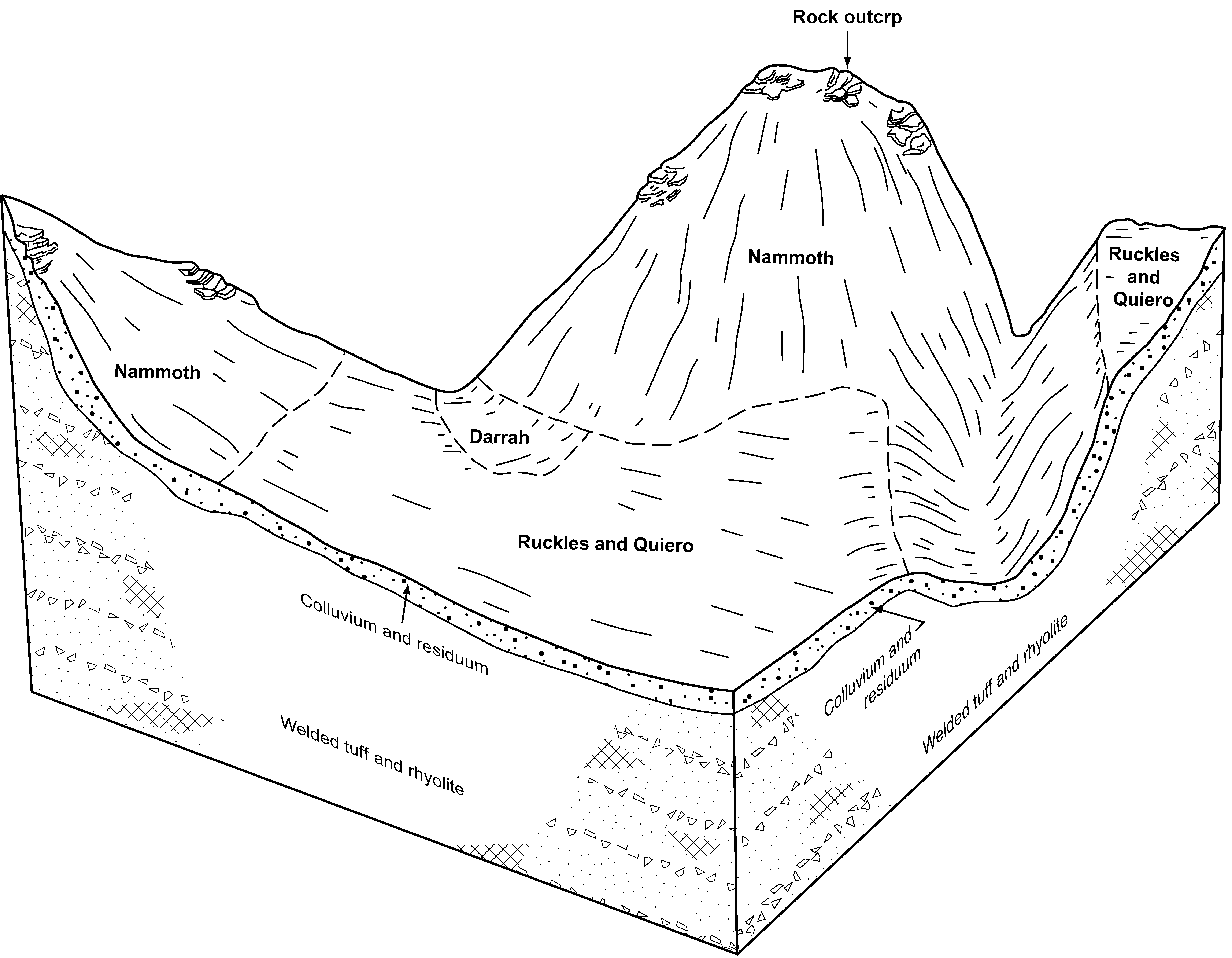
Quiero-Ruckles-Nammoth complex, 1 to 12 percent slopes | 152 | 7705 | 81884 | 2r6f | id681 | 1993 | 1:24000 |
Perla-Darrah-Ruckles complex, 1 to 4 percent slopes | 143 | 3075 | 81874 | 2r63 | id681 | 1993 | 1:24000 |
Nammoth-Ruckles-Rock outcrop complex, 1 to 12 percent slopes | 137 | 2515 | 81867 | 2r5w | id681 | 1993 | 1:24000 |
Immiant-Ruckles-Rock outcrop complex, 4 to 20 percent slopes | 83 | 12261 | 2519610 | 2r1w | id685 | 2012 | 1:24000 |
Ruckles gravelly clay loam, 1 to 8 percent slopes, extremely stony | 139 | 8694 | 2519497 | 2qy7 | id685 | 2012 | 1:24000 |
Ruckles-Ruclick complex, 12 to 35 percent south slopes | 143D | 31242 | 62114 | 22mp | or604 | 1988 | 1:24000 |
Ruckles-Ruclick complex, 35 to 50 percent south slopes | 143E | 18809 | 62115 | 22mq | or604 | 1988 | 1:24000 |
Ruckles-Ruclick complex, 2 to 12 percent slopes | 142C | 18187 | 62113 | 22mn | or604 | 1988 | 1:24000 |
Ruckles-Ruclick complex, 50 to 70 percent south slopes | 143F | 7432 | 62116 | 22mr | or604 | 1988 | 1:24000 |
Bakeoven-Ruckles complex, 2 to 12 percent slopes | 10C | 4527 | 62070 | 22l8 | or604 | 1988 | 1:24000 |
Ruckles-Ruclick-Snellby complex, 35 to 50 percent slopes | 144E | 3968 | 62117 | 22ms | or604 | 1988 | 1:24000 |
Ruckles-Ruclick-Snellby complex, 50 to 70 percent slopes | 144F | 2741 | 62118 | 22mt | or604 | 1988 | 1:24000 |
Rock outcrop-Ruckles complex, 50 to 70 percent south slopes | 135F | 1435 | 62104 | 22mc | or604 | 1988 | 1:24000 |
Stukel-Ruckles complex, 3 to 30 percent slopes | 172YD | 8497 | 3434694 | wg3q | or618 | | 1:24000 |
Jeniped-Ruckles complex, 3 to 15 percent slopes | 395 | 1106 | 3435019 | 2xfts | or618 | | 1:24000 |
Ruckles-Exfo-Lickskillet complex, 15 to 60 percent south slopes | 230 | 628 | 3434899 | 20g34 | or618 | | 1:24000 |
Simas-Ruckles-Rock outcrop complex, 40 to 80 percent north slopes | 120F | 8363 | 63423 | 23zx | or620 | 1992 | 1:24000 |
Simas-Ruckles-Rock outcrop complex, 40 to 80 percent south slopes | 121F | 7277 | 63424 | 23zy | or620 | 1992 | 1:24000 |
Simas-Ruckles complex, 15 to 40 percent south slopes | 119D | 3837 | 63417 | 23zq | or620 | 1992 | 1:24000 |
Simas-Ruckles complex, 15 to 40 percent north slopes | 118D | 2570 | 63415 | 23zn | or620 | 1992 | 1:24000 |
Ruckles very stony clay loam, 12 to 45 percent slopes | 57E | 6630 | 63999 | 24lh | or625 | 1979 | 1:20000 |
Ruckles very stony clay loam, 1 to 12 percent slopes | 57C | 2142 | 63998 | 24lg | or625 | 1979 | 1:20000 |
Ruckles very stony clay loam, 45 to 65 percent slopes | 57F | 690 | 64000 | 24lj | or625 | 1979 | 1:20000 |
Ruckles-Lickskillet-Redcliff complex, 15 to 30 percent south slopes | 141D | 1127 | 3425013 | 26j2 | or627 | | 1:24000 |
Ruckles very cobbly loam, 3 to 20 percent slopes | 140C | 84 | 3425059 | t73m | or627 | | 1:24000 |
Sorf-Ruckles complex, 15 to 30 percent south slopes | 144D | 68 | 3425015 | nfq4 | or627 | | 1:24000 |
Ruckles very cobbly loam, 0 to 3 percent slopes | 140A | 19 | 3425056 | nfq2 | or627 | | 1:24000 |
Ruckles-Ruclick-Rock outcrop complex, 10 to 50 percent south slopes | 8001 | 82963 | 2482050 | 2p9s4 | or645 | | 1:24000 |
Bakeoven-Ruckles-Ruclick complex, 2 to 25 percent slopes | 8000 | 43218 | 2486771 | 2pgpf | or645 | | 1:24000 |
Lookout-Ruckles complex, 2 to 15 percent slopes | 8023 | 31385 | 2482199 | 2p9xy | or645 | | 1:24000 |
Skedaddle-Ruckles, stony surface-Rubble land complex, 12 to 25 percent slopes | 8063 | 11414 | 3459382 | 31jfd | or645 | | 1:24000 |
Ruclick-Bakeoven-Ruckles complex, 8 to 40 percent slopes | 8006 | 10231 | 2482082 | 2p9t5 | or645 | | 1:24000 |
Simas-Ruckles-Rock outcrop complex, 15 to 40 percent south slopes | 356D | 387 | 3472546 | 269k | or666 | 1970 | 1:31680 |
Simas-Ruckles-Twickenham complex, 2 to 15 percent slopes | 310C | 156 | 3472532 | 268j | or666 | 1970 | 1:31680 |
Sorf-Ruckles complex, 15 to 30 percent south slopes | 144D | 79 | 3472521 | nfq4 | or666 | 1970 | 1:31680 |
Ruckles-Lickskillet-Redcliff complex, 15 to 30 percent south slopes | 141D | 37 | 3472472 | 26j2 | or666 | 1970 | 1:31680 |
Simas-Ruckles-Antoken complex, 2 to 40 percent slopes | 127 | 7626 | 63099 | 23ng | or674 | 1993 | 1:24000 |
Ruclick-Ruckles complex, 12 to 30 percent slopes | 119 | 5270 | 63083 | 23my | or674 | 1993 | 1:24000 |
Ruclick-Ruckles complex, 30 to 55 percent slopes | 120 | 5109 | 63086 | 23n1 | or674 | 1993 | 1:24000 |
Ruckles-Simas-Rock outcrop complex, 40 to 80 percent slopes | 118 | 4016 | 63081 | 23mw | or674 | 1993 | 1:24000 |
Ruckles-Simas complex, 40 to 80 percent slopes | 117 | 2380 | 63079 | 23mt | or674 | 1993 | 1:24000 |
Ruckles-Rock outcrop complex, 55 to 80 percent slopes | 116 | 1856 | 63078 | 23ms | or674 | 1993 | 1:24000 |
Simas-Ruckles-Rock outcrop complex, 15 to 40 percent south slopes | 356D | 19734 | 3421692 | 269k | or677 | | 1:24000 |
Sorf-Ruckles complex, 15 to 30 percent south slopes | 144D | 10694 | 3421706 | nfq4 | or677 | | 1:24000 |
Ruckles-Lickskillet-Redcliff complex, 15 to 30 percent south slopes | 141D | 9635 | 3421702 | 26j2 | or677 | | 1:24000 |
Simas-Ruckles-Twickenham complex, 2 to 15 percent slopes | 310C | 7702 | 3421708 | 268j | or677 | | 1:24000 |
Rock outcrop-Ruckles-Lickskillet complex, 30 to 70 percent south slopes | 167E | 4784 | 3421746 | 227rm | or677 | | 1:24000 |
Ruckles-Rock outcrop complex, 15 to 30 percent south slopes | 164D | 1602 | 3421910 | 227rl | or677 | | 1:24000 |
Ruckles very cobbly loam, 0 to 3 percent slopes | 140A | 1149 | 3421956 | nfq2 | or677 | | 1:24000 |
Ruckles very cobbly loam, 3 to 20 percent slopes | 140C | 866 | 3421974 | t73m | or677 | | 1:24000 |
Ruckles-Rock outcrop complex, 15 to 30 percent north slopes | 363D | 800 | 3422012 | 269x | or677 | | 1:24000 |

