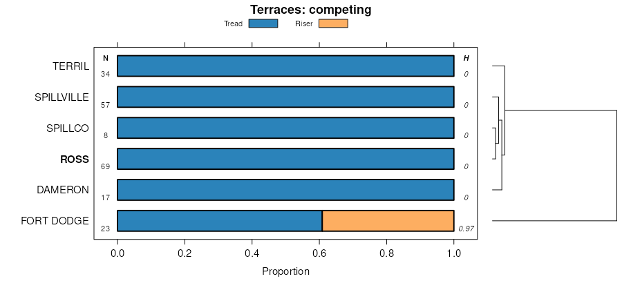
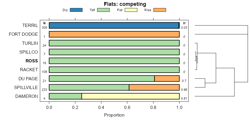
| Ross silt loam, 0 to 2 percent slopes, occasionally flooded | 8073A | 867 | 2378687 | 2kv6v | il001 | 1997 | 1:12000 |
Ross silt loam, 0 to 2 percent slopes, rarely flooded | 7073A | 1761 | 1862794 | 20jd4 | il011 | 2007 | 1:12000 |
Ross silt loam, 0 to 2 percent slopes, frequently flooded | 3073A | 496 | 262833 | 8thh | il017 | 2003 | 1:12000 |
Ross silt loam, 0 to 2 percent slopes, frequently flooded | 3073A | 413 | 261778 | 8sdg | il021 | 1999 | 1:12000 |
Ross silt loam, 0 to 2 percent slopes, frequently flooded | 3073A | 1336 | 1428415 | 1jycx | il029 | 2005 | 1:12000 |
Ross silt loam, 0 to 2 percent slopes, frequently flooded | 3073A | 279 | 1592479 | 1qg39 | il039 | 2005 | 1:12000 |
Ross loam, 0 to 2 percent slopes, occasionally flooded | 8073A | 1011 | 1415887 | 1jjbs | il063 | 2005 | 1:12000 |
Ross loam, 0 to 2 percent slopes, frequently flooded | 3073A | 855 | 1547485 | 1ny8w | il063 | 2005 | 1:12000 |
Ross silt loam, 0 to 2 percent slopes, frequently flooded | 3073A | 523 | 175177 | 5w8w | il067 | 1993 | 1:15840 |
Ross loam, 0 to 2 percent slopes, frequently flooded | 3073A | 4031 | 1427833 | 1jxs4 | il099 | 2006 | 1:12000 |
Ross loam, 0 to 2 percent slopes, occasionally flooded | 8073A | 1045 | 1427837 | 1jxs8 | il099 | 2006 | 1:12000 |
Ross silt loam, 0 to 2 percent slopes, rarely flooded | 7073A | 658 | 1427834 | 1jxs5 | il099 | 2006 | 1:12000 |
Ross silt loam, 0 to 2 percent slopes, rarely flooded | 7073A | 1172 | 923927 | 100f3 | il103 | 2004 | 1:12000 |
Ross loam, 0 to 2 percent slopes, frequently flooded | 3073A | 516 | 176961 | 5y4f | il105 | 1991 | 1:15840 |
Ross silt loam, 0 to 2 percent slopes, frequently flooded | 3073A | 662 | 1595764 | 1qkj8 | il107 | 2006 | 1:12000 |
Ross loam, 0 to 2 percent slopes, occasionally flooded | 8073A | 667 | 199145 | 6p71 | il113 | 2000 | 1:12000 |
Ross silt loam, 0 to 2 percent slopes, frequently flooded | 3073A | 15 | 1913979 | 227n8 | il115 | 2007 | 1:12000 |
Ross silt loam, 0 to 2 percent slopes, occasionally flooded | 8073A | 2625 | 182237 | 63mm | il123 | 1997 | 1:15840 |
Ross silt loam, 0 to 2 percent slopes, frequently flooded | 3073A | 1412 | 1406257 | 1j6b4 | il129 | 2005 | 1:12000 |
Ross silt loam, 0 to 2 percent slopes, frequently flooded | 3073A | 143 | 1672175 | 1t414 | il137 | 1984 | 1:15840 |
Ross loam, 0 to 2 percent slopes, occasionally flooded | 8073A | 1132 | 1144335 | 17ds1 | il141 | 2005 | 1:12000 |
Ross silt loam, 0 to 2 percent slopes, frequently flooded | 3073A | 1064 | 199291 | 6pcr | il167 | 1999 | 1:12000 |
Ross loam, 0 to 2 percent slopes, occasionally flooded | 8073A | 44 | 2542108 | 2qvgm | il171 | 1984 | 1:12000 |
Ross silt loam, 0 to 2 percent slopes, frequently flooded | 3073A | 8332 | 179395 | 60ny | il179 | 1991 | 1:15840 |
Ross silt loam, 0 to 2 percent slopes, rarely flooded | 7073A | 3338 | 793124 | vm9n | il195 | 2003 | 1:12000 |
Ross loam, 0 to 2 percent slopes, occasionally flooded | 8073A | 3221 | 1913192 | 226tw | il203 | 2008 | 1:12000 |
Ross fine sandy loam, protected | Rt | 772 | 165232 | 5jy2 | in015 | 1987 | 1:15840 |
Ross loam, rarely flooded | Ru | 248 | 165233 | 5jy3 | in015 | 1987 | 1:15840 |
Ross loam, frequently flooded | Ro | 687 | 162977 | 5glb | in027 | 1969 | 1:20000 |
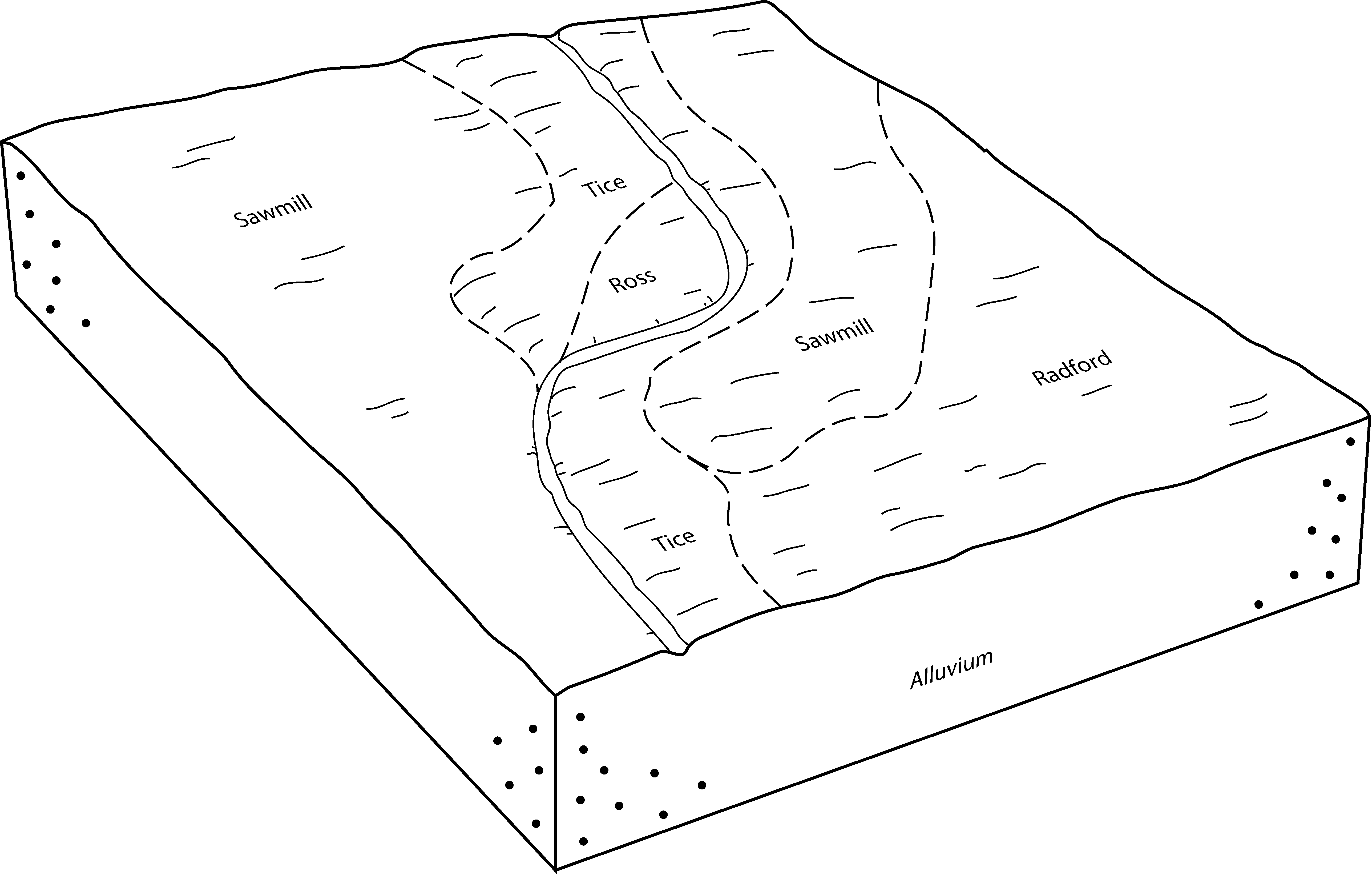
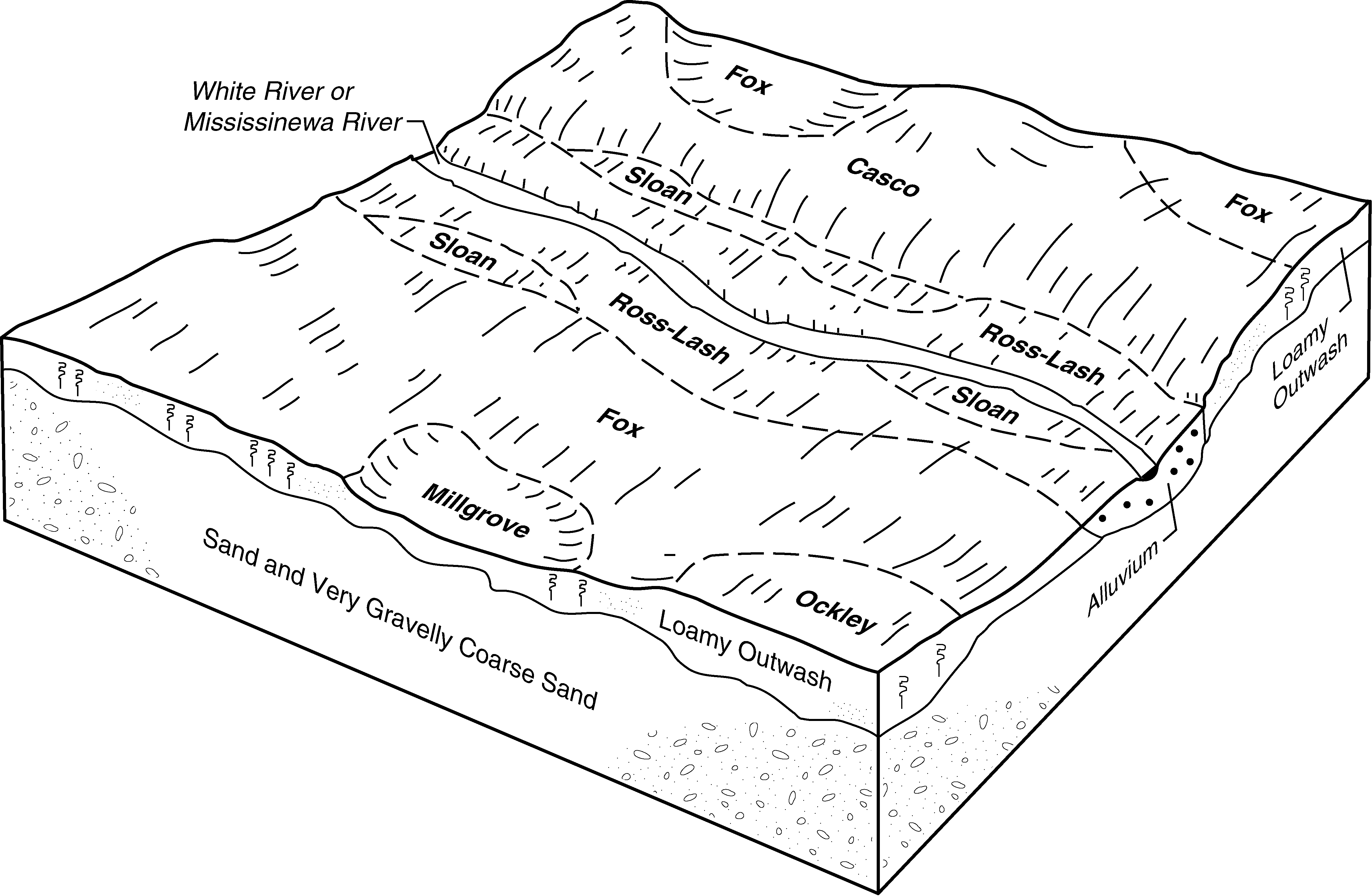
Ross-Lash loams, 0 to 1 percent slopes, frequently flooded, brief duration | RroAH | 987 | 164960 | 5jn9 | in035 | 1997 | 1:12000 |
Ross silt loam, 0 to 2 percent slopes, occasionally flooded | Ro | 208 | 1612913 | 2w56j | in041 | 1958 | 1:15840 |
Ross silt loam, 0 to 2 percent slopes, rarely flooded | Rm | 564 | 162300 | 2w56k | in047 | 1984 | 1:15840 |
Ross loam, 0 to 2 percent slopes, occasionally flooded | Ro | 803 | 3186675 | 2w564 | in057 | 1976 | 1:15840 |
Ross loam, 0 to 2 percent slopes, frequently flooded | Rs | 654 | 161686 | 2x884 | in081 | 1975 | 1:15840 |
Ross loam, 0 to 2 percent slopes, occasionally flooded | Ro | 802 | 162121 | 2w564 | in095 | 1965 | 1:15840 |
Ross silt loam, 0 to 2 percent slopes, occasionally flooded | Rs | 502 | 162122 | 2w56j | in095 | 1965 | 1:15840 |
Ross loam | Ro | 921 | 161989 | 5fkg | in103 | 1977 | 1:20000 |
Ross loam, 0 to 2 percent slopes, occasionally flooded | Ro | 1073 | 163251 | 2w564 | in109 | 1979 | 1:15840 |
Ross silt loam, frequently flooded | Rv | 164 | 163745 | 5hd3 | in111 | 1990 | 1:15840 |
Ross silt loam, 0 to 2 percent slopes, frequently flooded | Rt | 4671 | 160753 | 2w56h | in145 | 1968 | 1:15840 |
Ross loam, sandy substratum | Rs | 644 | 160752 | 5d8k | in145 | 1968 | 1:15840 |
Ross silt loam | Rt | 2299 | 162714 | 5g9v | in153 | 1966 | 1:15840 |
Ross silt loam, protected | Rz | 137 | 164285 | 5hyj | in157 | 1990 | 1:15840 |
Ross silt loam, 0 to 2 percent slopes, occasionally flooded | Ro | 34 | 1613062 | 2w56j | in161 | 1958 | 1:15840 |
Ross loam, 0 to 2 percent slopes, frequently flooded | Rz | 627 | 161275 | 30kcc | in179 | 1988 | 1:15840 |
Ross loam, 0 to 2 percent slopes, occasionally flooded | Rn | 4556 | 169790 | 2w564 | oh017 | 1977 | 1:15840 |
Ross-Urban land complex, 0 to 2 percent slopes, occasionally flooded | RnU | 182 | 3381131 | 30tr7 | oh017 | 1977 | 1:15840 |
Urban land-Ross complex, 0 to 2 percent slopes, occasionally flooded | URn | 76 | 3381132 | 30tr8 | oh017 | 1977 | 1:15840 |
Ross silt loam, 0 to 2 percent slopes, occasionally flooded | Rn | 389 | 171480 | 2w56j | oh021 | 1966 | 1:15840 |
Ross silty clay loam, rarely flooded | Ro | 14 | 1413797 | 1jg5c | oh021 | 1966 | 1:15840 |
Ross silt loam, 0 to 2 percent slopes, occasionally flooded | Rn | 2385 | 171770 | 2w56j | oh023 | 1997 | 1:15840 |
Ross silty clay loam, rarely flooded | Ro | 690 | 171771 | 5rr0 | oh023 | 1997 | 1:15840 |
Ross silt loam, 0 to 2 percent slopes, occasionally flooded | Rn | 153 | 168812 | 2w56j | oh025 | 1972 | 1:20000 |
Ross loam, 0 to 1 percent slopes, occasionally flooded | RnA | 248 | 172009 | 5rzp | oh027 | 1999 | 1:12000 |
Ross silt loam, 0 to 2 percent slopes, frequently flooded | RoA | 72 | 172010 | 2w56h | oh027 | 1999 | 1:12000 |
Ross silt loam, occasionally flooded | Ru | 329 | 168469 | 5n9h | oh039 | 1981 | 1:15840 |
Ross silt loam, 0 to 2 percent slopes, occasionally flooded | Rs | 1393 | 169270 | 2w56j | oh047 | 1968 | 1:15840 |
Ross silt loam, 0 to 2 percent slopes, occasionally flooded | Rs | 3437 | 167933 | 2w56j | oh049 | 1977 | 1:15840 |
Ross loam, 0 to 2 percent slopes, occasionally flooded | Rs | 3601 | 169343 | 2w564 | oh057 | 1974 | 1:15840 |
Ross loam, 0 to 1 percent slopes, occasionally flooded | RpA | 234 | 1857483 | 20bvt | oh057 | 1974 | 1:15840 |
Ross silt loam, 0 to 2 percent slopes, frequently flooded | RqA | 16 | 1857484 | 2w56h | oh057 | 1974 | 1:15840 |
Ross loam, rarely flooded | Rn | 582 | 169433 | 5p9l | oh061 | 1980 | 1:15840 |
Urban land-Mollic Udarents-Ross complex, 0 to 2 percent slopes, rarely flooded | UMSXAR | 59 | 2652909 | 2pyz3 | oh061 | 1980 | 1:15840 |
Ross loam, 0 to 2 percent slopes, occasionally flooded | Rm | 25 | 1720806 | 2w564 | oh061 | 1980 | 1:15840 |
Ross-Urban land complex, rarely flooded | RnU | 8 | 3422054 | 31ggz | oh061 | 1980 | 1:15840 |
Ross loam | Rs | 547 | 169036 | 5nws | oh069 | 1968 | 1:15840 |
Ross silt loam, 0 to 2 percent slopes, occasionally flooded | Rn | 2944 | 1420511 | 2w56j | oh071 | 1973 | 1:15840 |
Ross loam, occasionally flooded | Rs | 977 | 169866 | 5prk | oh095 | 1978 | 1:15840 |
Ross silt loam, 0 to 2 percent slopes, occasionally flooded | Rs | 987 | 169913 | 2w56j | oh097 | 1978 | 1:15840 |
Ross silt loam, 0 to 2 percent slopes, occasionally flooded | Rs | 2876 | 169537 | 2w56j | oh109 | 1973 | 1:15840 |
Ross silt loam, 0 to 2 percent slopes, occasionally flooded | Rs | 10713 | 170311 | 2w56j | oh113 | 1969 | 1:15840 |
Ross-Urban land complex | Rt | 3628 | 170312 | 5q6y | oh113 | 1969 | 1:15840 |
Ross loam, 0 to 2 percent slopes, occasionally flooded | Rs | 6405 | 171295 | 2w564 | oh129 | 1977 | 1:15840 |
Ross silt loam, 0 to 2 percent slopes, overwash, frequently flooded | Rt | 859 | 171296 | 2w56m | oh129 | 1977 | 1:15840 |
Ross silt loam, 0 to 2 percent slopes, occasionally flooded | Ru | 301 | 1403058 | 2w56j | oh129 | 1977 | 1:15840 |
Ross silt loam, 0 to 2 percent slopes, occasionally flooded | Rn | 6960 | 170951 | 2w56j | oh141 | 1997 | 1:15840 |
Ross silt loam, occasionally flooded | Ru | 1170 | 170010 | 5px6 | oh147 | 1978 | 1:15840 |
Ross silt loam | Ro | 772 | 1406098 | 1j650 | oh159 | 1970 | 1:15840 |
Ross loam, 0 to 2 percent slopes, occasionally flooded | Rn | 1975 | 171390 | 2w564 | oh165 | 1967 | 1:20000 |
Ross-Urban land complex, 0 to 2 percent slopes, occasionally flooded | RnU | 999 | 3422300 | 30tr7 | oh165 | 1967 | 1:20000 |
Urban land-Ross complex, 0 to 2 percent slopes, occasionally flooded | URn | 165 | 3422301 | 30tr8 | oh165 | 1967 | 1:20000 |
Ross loam, 0 to 1 percent slopes, occasionally flooded | RmA | 112 | 1700947 | 1v2z8 | oh165 | 1967 | 1:20000 |
Ross soils | 28 | 2065 | 517102 | kc2q | va121 | 1980 | 1:15840 |
