| Rosebud-Escabosa loams, 3 to 5 percent slopes | 96 | 20811 | 94583 | 35f2 | co075 | 1974 | 1:24000 |
Wages-Rosebud loams, 5 to 9 percent slopes | 124 | 11167 | 94487 | 359z | co075 | 1974 | 1:24000 |
Rosebud-Escabosa loams, 5 to 9 percent slopes | 97 | 11146 | 94584 | 35f3 | co075 | 1974 | 1:24000 |
Rosebud-Escabosa-Iliff complex, 0 to 3 percent slopes | 98 | 9209 | 94585 | 35f4 | co075 | 1974 | 1:24000 |
Wages-Rosebud loams, 3 to 5 percent slopes | 123 | 1096 | 94486 | 359y | co075 | 1974 | 1:24000 |
Rosebud fine sandy loam, 0 to 6 percent slopes | 58 | 7011 | 95152 | 360f | co617 | 1980 | 1:24000 |
Rosebud fine sandy loam, 6 to 9 percent slopes | 59 | 3470 | 95153 | 360g | co617 | 1980 | 1:24000 |
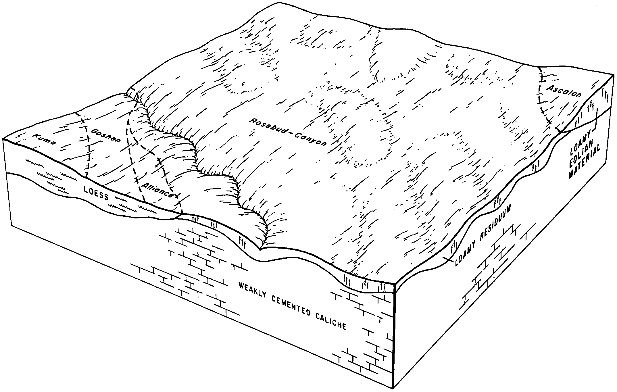
Rosebud-Canyon loams, 3 to 6 percent slopes | 1740 | 8721 | 1692504 | 2wz9p | ne007 | 1988 | 1:20000 |
Rosebud loam, 1 to 3 percent slopes | 1726 | 2648 | 1692503 | 2wz8q | ne007 | 1988 | 1:20000 |
Rosebud-Canyon loams, 1 to 3 percent slopes | 1739 | 195 | 2228144 | 2wz8n | ne007 | 1988 | 1:20000 |
Rosebud-Blanche complex , 1 to 3 percent slopes | 1735 | 67 | 2228143 | 2dskl | ne007 | 1988 | 1:20000 |
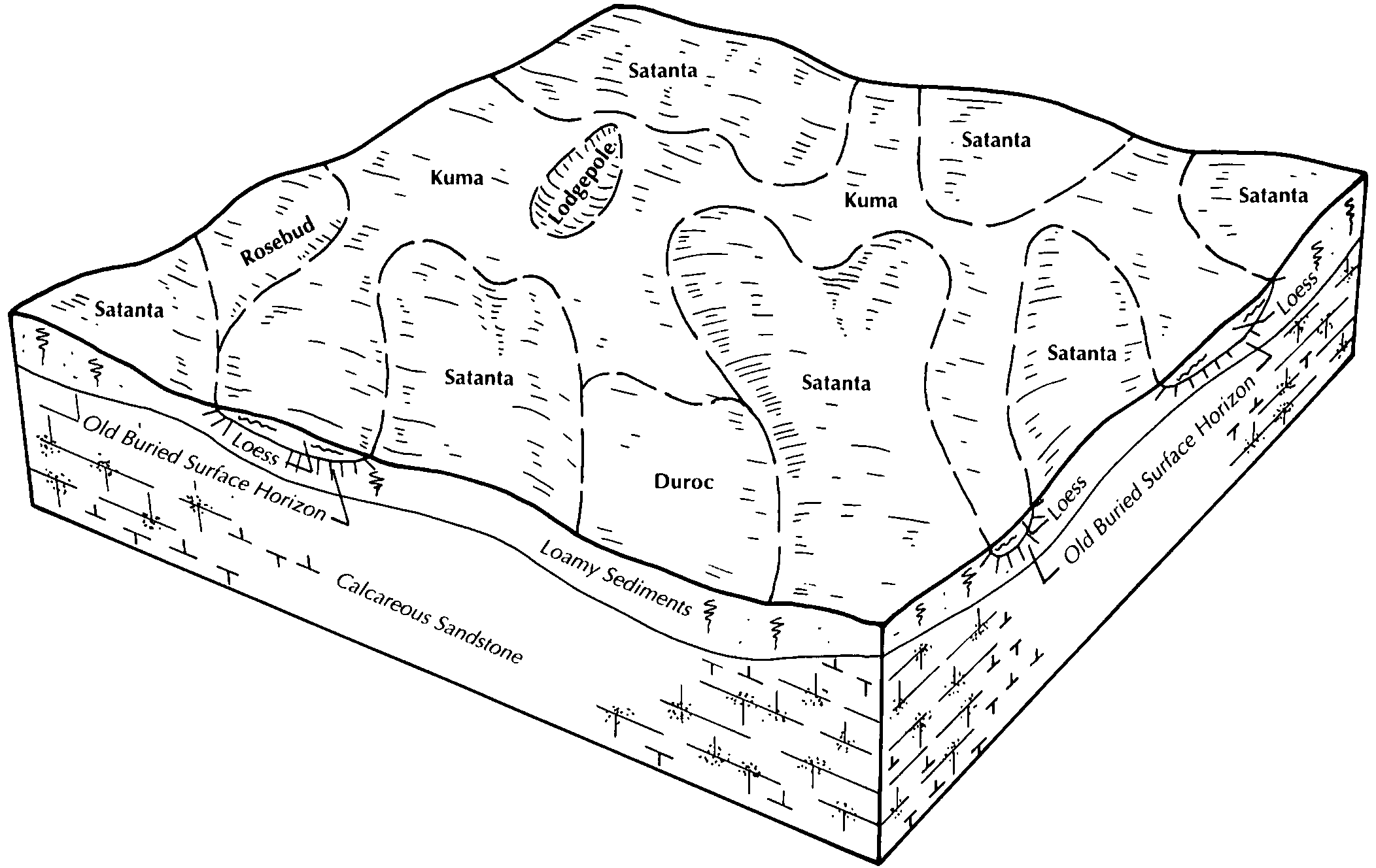
Rosebud-Canyon complex, 3 to 9 percent slopes | 1736 | 25296 | 357822 | d0bn | ne013 | 1980 | 1:20000 |
Alliance-Rosebud loams, 3 to 6 percent slopes | 5109 | 17799 | 357763 | d08r | ne013 | 1980 | 1:20000 |
Alliance-Rosebud loams, 1 to 3 percent slopes | 5108 | 13152 | 357762 | 2tvv2 | ne013 | 1980 | 1:20000 |
Rosebud loam, 1 to 3 percent slopes | 1726 | 11418 | 357821 | 2wf32 | ne013 | 1980 | 1:20000 |
Rosebud loam, 0 to 1 percent slopes | 1725 | 7377 | 357820 | d0bl | ne013 | 1980 | 1:20000 |
Rosebud-Canyon complex, 9 to 30 percent slopes | 1737 | 3920 | 357823 | d0bp | ne013 | 1980 | 1:20000 |
Alliance-Rosebud loams, 6 to 11 percent slopes | 5110 | 3385 | 357764 | d08s | ne013 | 1980 | 1:20000 |
Rosebud-Canyon loams, 1 to 3 percent slopes | 1739 | 27965 | 1699056 | 2wz8p | ne029 | 1980 | 1:20000 |
Rosebud loam, 0 to 1 percent slopes | 1725 | 16840 | 1699053 | 2wz90 | ne029 | 1980 | 1:20000 |
Rosebud-Canyon loams, 3 to 6 percent slopes | 1740 | 9845 | 1699057 | 2wz9n | ne029 | 1980 | 1:20000 |
Rosebud loam, 1 to 3 percent slopes | 1726 | 7185 | 1699054 | 2wz8q | ne029 | 1980 | 1:20000 |
Rosebud-Canyon loams, 0 to 1 percent slopes | 1738 | 6844 | 1699055 | 1v107 | ne029 | 1980 | 1:20000 |
Rosebud-Canyon loams, 6 to 12 percent slopes, eroded | 1743 | 1799 | 1699058 | 1v10b | ne029 | 1980 | 1:20000 |
Rosebud loam, 1 to 3 percent slopes | 1726 | 22842 | 1698705 | 2wz8q | ne033 | 1989 | 1:20000 |
Rosebud-Canyon complex, 3 to 9 percent slopes | 1736 | 15142 | 1698707 | 1v0n0 | ne033 | 1989 | 1:20000 |
Rosebud loam, 3 to 6 percent slopes | 1727 | 12312 | 1698706 | 1v0mz | ne033 | 1989 | 1:20000 |
Rosebud loam, 0 to 1 percent slopes | 1725 | 4643 | 1698704 | 2wz8z | ne033 | 1989 | 1:20000 |
Rosebud-Canyon loams, 1 to 3 percent slopes | 1739 | 812 | 2219682 | 2wz8n | ne033 | 1989 | 1:20000 |
Rosebud-Hemingford loams, 0 to 1 percent slopes | 1744 | 134 | 2219683 | 2dhrp | ne033 | 1989 | 1:20000 |
Alliance-Rosebud loams, 1 to 3 percent slopes | 5108 | 115 | 2219699 | 2dhs6 | ne033 | 1989 | 1:20000 |
Rosebud-Canyon loams, 3 to 9 percent slopes | 1742 | 32262 | 358156 | 2tvvj | ne045 | 1973 | 1:20000 |
Rosebud silt loam, 1 to 3 percent slopes | 1730 | 6100 | 358155 | d0pd | ne045 | 1973 | 1:20000 |
Rosebud loam, 1 to 3 percent slopes | 1726 | 122 | 2217549 | 2wf32 | ne045 | 1973 | 1:20000 |
Rosebud-Canyon complex, 3 to 9 percent slopes | 1736 | 23 | 2217571 | 2dfkk | ne045 | 1973 | 1:20000 |
Alliance-Rosebud loams, 1 to 3 percent slopes | 5108 | 16607 | 1698794 | 1v0qt | ne049 | 2000 | 1:24000 |
Alliance-Rosebud loams, 1 to 3 percent slopes | 5108 | 4362 | 2219225 | 2dh8x | ne069 | 1995 | 1:20000 |
Rosebud loam, 1 to 3 percent slopes | 1726 | 2268 | 1698905 | 2wz8q | ne101 | 1990 | 1:20000 |
Rosebud loam, 3 to 9 percent slopes | 1728 | 907 | 1698906 | 1v0vf | ne101 | 1990 | 1:20000 |
Rosebud-Canyon loams, 3 to 6 percent slopes | 1740 | 10 | 2219595 | 2wz9n | ne101 | 1990 | 1:20000 |
Rosebud-Canyon loams, 1 to 3 percent slopes | 1739 | 54827 | 1692552 | 2wz8n | ne105 | 2004 | 1:24000 |
Brownson-Rosebud-Canyon loams, 0 to 3 percent slopes | 1524 | 31784 | 1692539 | 1tt71 | ne105 | 2004 | 1:24000 |
Rosebud-Hemingford loams, 0 to 1 percent slopes | 1744 | 23284 | 1692553 | 1tt7h | ne105 | 2004 | 1:24000 |
Rosebud loam, 0 to 1 percent slopes | 1725 | 17276 | 1692551 | 2wz8z | ne105 | 2004 | 1:24000 |
Rosebud-Blanche complex , 1 to 3 percent slopes | 1735 | 10981 | 1692554 | 1tt7j | ne105 | 2004 | 1:24000 |
Rosebud-Tassel sandy loams, 0 to 3 percent slopes | 1745 | 8283 | 1692555 | 1tt7k | ne105 | 2004 | 1:24000 |
Rosebud loam, 1 to 3 percent slopes | 1726 | 21 | 2227926 | 2wz8q | ne105 | 2004 | 1:24000 |
Rosebud loam, 1 to 3 percent slopes | 1726 | 37364 | 1698981 | 2wz8q | ne135 | 1987 | 1:20000 |
Rosebud-Canyon loams, 1 to 3 percent slopes | 1739 | 13471 | 1698982 | 2wz8p | ne135 | 1987 | 1:20000 |
Rosebud-Canyon loams, 3 to 6 percent slopes | 1740 | 11749 | 1698983 | 2wz9n | ne135 | 1987 | 1:20000 |
Rosebud loam, 0 to 1 percent slopes | 1725 | 7485 | 1698980 | 2wz90 | ne135 | 1987 | 1:20000 |
Rosebud-Canyon loams, 6 to 12 percent slopes, eroded | 1743 | 1336 | 1698984 | 1v0xy | ne135 | 1987 | 1:20000 |
Rosebud loam, 6 to 9 percent slopes | 1729 | 1205 | 1653782 | 1shwt | ne157 | 1965 | 1:20000 |
Rosebud loam, 1 to 3 percent slopes | 1726 | 4729 | 100631 | 2wf32 | ne161 | 1992 | 1:20000 |
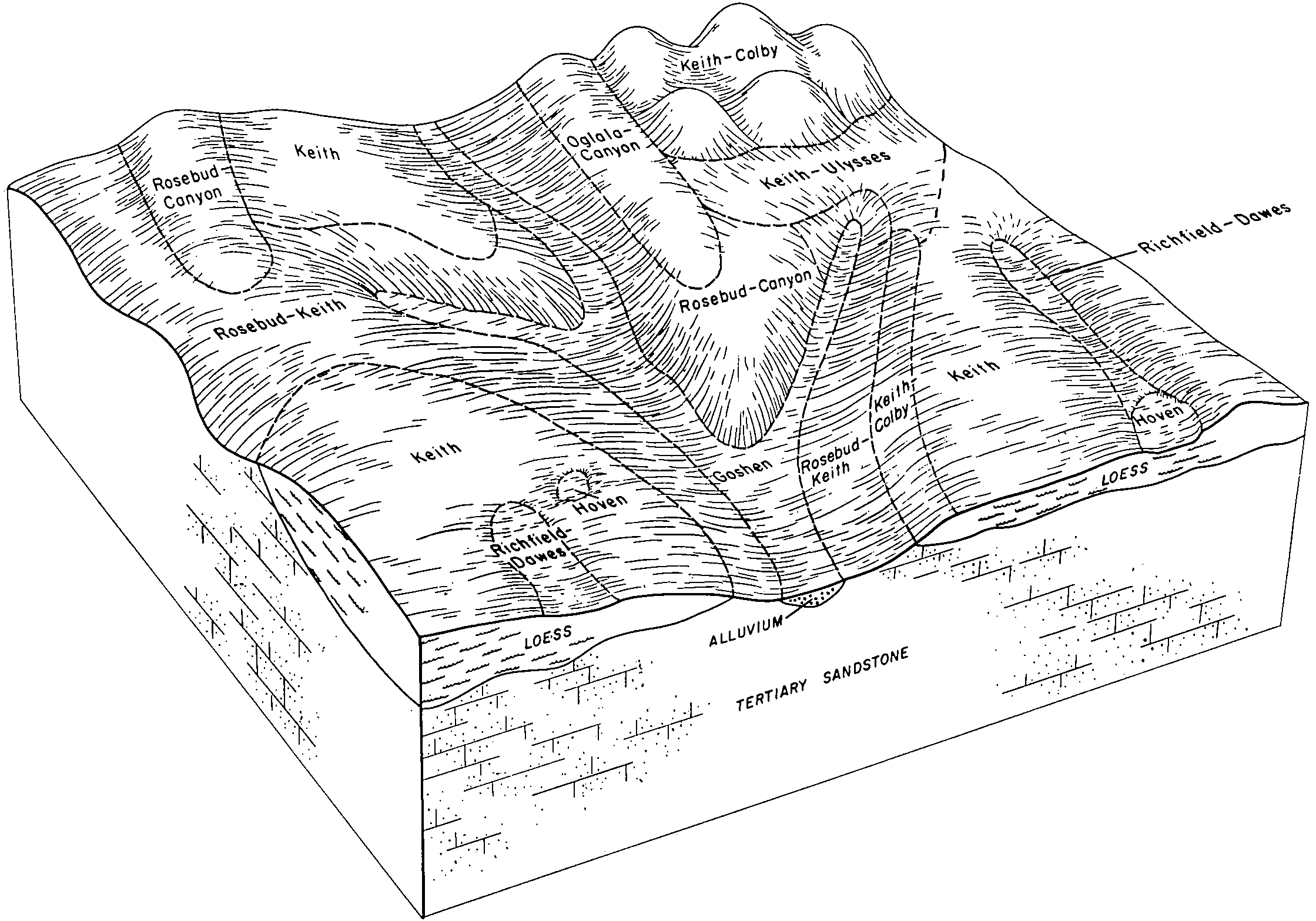
Keith-Rosebud silt loams, 2 to 6 percent slopes | KrB | 83875 | 352749 | 2tzzc | sd007 | 2004 | 1:20000 |
Keith-Rosebud silt loams, 0 to 2 percent slopes | KrA | 12263 | 352748 | 2tzzb | sd007 | 2004 | 1:20000 |
Canyon-Rosebud loams, 3 to 12 percent slopes | CyD2 | 9092 | 352727 | 2zj4d | sd007 | 2004 | 1:20000 |
Oglala-Rosebud silt loams, 3 to 6 percent slopes | OrB | 2211 | 352758 | cv29 | sd007 | 2004 | 1:20000 |
Oglala-Rosebud silt loams, 0 to 3 percent slopes | OrA | 1751 | 352757 | cv28 | sd007 | 2004 | 1:20000 |
Rosebud and Canyon soils, 9 to 21 percent slopes | RcE | 3974 | 353027 | cvbz | sd121 | 1967 | 1:31680 |
Rosebud-Canyon loams, 6 to 9 percent slopes | RuC | 5175 | 354443 | cwtn | sd123 | 1975 | 1:20000 |
Rosebud-Canyon loams, 9 to 15 percent slopes | RuD | 2133 | 354444 | cwtp | sd123 | 1975 | 1:20000 |
Rosebud loam, 3 to 6 percent slopes | RsB | 988 | 354442 | cwtm | sd123 | 1975 | 1:20000 |
Keith-Rosebud-Canyon complex, 5 to 9 percent slopes | KsC | 18949 | 2995900 | cv60 | sd610 | 1965 | 1:20000 |
Keith-Rosebud silt loams, 2 to 6 percent slopes | KrB | 3355 | 2925481 | 2tzzc | sd610 | 1965 | 1:20000 |
Rosebud-Canyon, moist loams, 2 to 6 percent slopes | U635B | 353 | 2485418 | 2pf8s | sd612 | 2011 | 1:20000 |
Rosebud-Canyon loams, 5 to 9 percent slopes | ReB | 30829 | 2582732 | cv4g | sd613 | 2011 | 1:24000 |
Rosebud-Keith silt loams, 3 to 9 percent slopes | RkC | 20458 | 2582733 | 2y6dz | sd613 | 2011 | 1:24000 |
Keith-Rosebud silt loams, 0 to 2 percent slopes | KrA | 6723 | 2582710 | 2tzzb | sd613 | 2011 | 1:24000 |
Rosebud-Canyon, moist loams, 2 to 6 percent slopes | U635B | 19 | 2582851 | 2pf8s | sd613 | 2011 | 1:24000 |
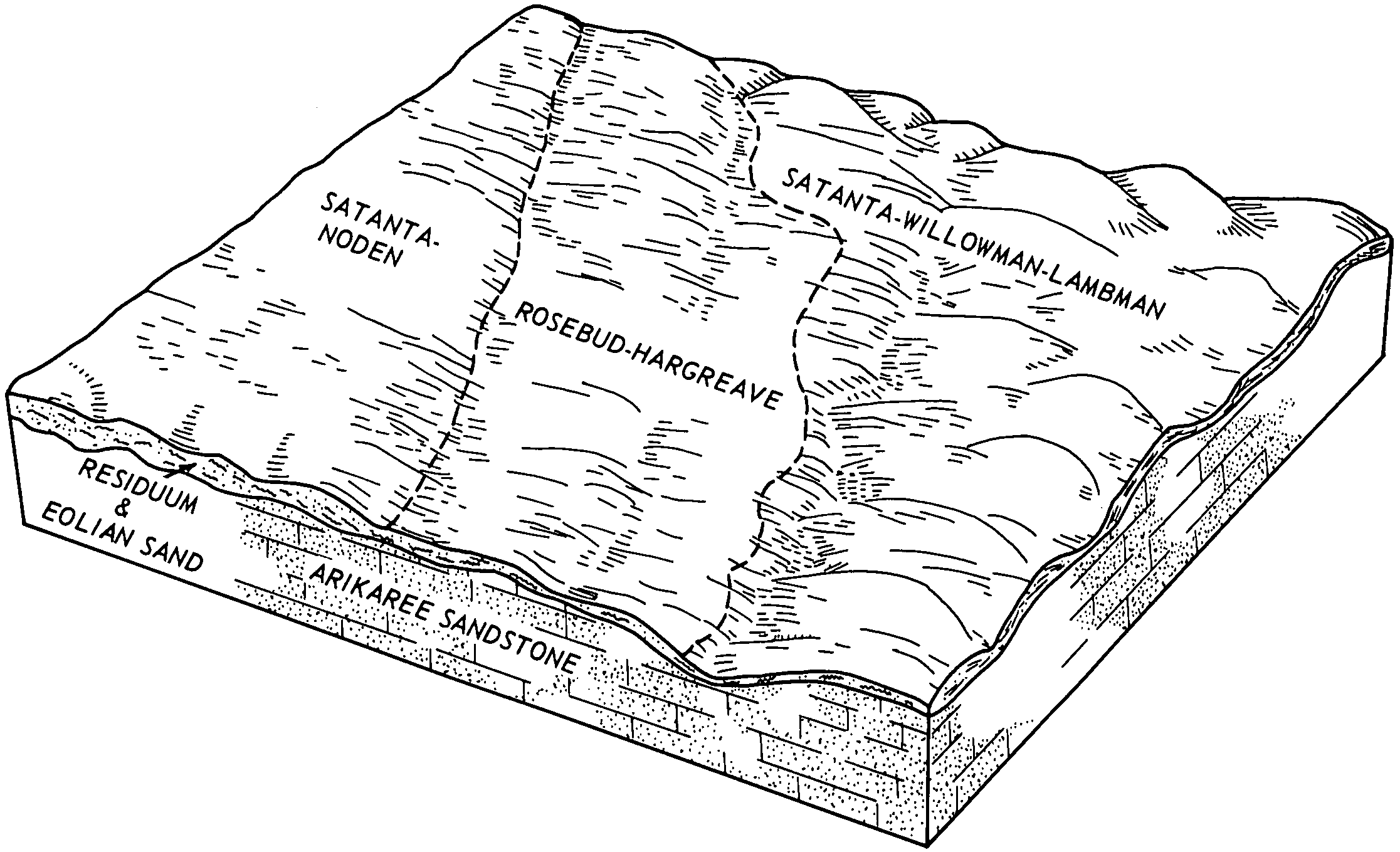
Rosebud and Hargreave fine sandy loams, 0 to 6 percent sl opes | RhB | 7973 | 104737 | 3hzm | wy615 | 1965 | 1:20000 |
Rosebud and Norka loams, 1 to 6 percent slopes | RnB | 6648 | 104739 | 3hzp | wy615 | 1965 | 1:20000 |
Rosebud-Dunday-Trelona loamy fine sands, 0 to 3 percent sl opes | ReA | 5509 | 104735 | 3hzk | wy615 | 1965 | 1:20000 |
Rosebud-Dunday-Trelona loamy fine sands, 3 to 10 percent s lopes | ReC | 4353 | 104736 | 3hzl | wy615 | 1965 | 1:20000 |
Rosebud-Trelona fine sandy loams, 0 to 6 percent slopes | RuB | 3882 | 104743 | 3hzt | wy615 | 1965 | 1:20000 |
Rosebud-Trelona complex, 0 to 6 percent slopes | RtB | 3563 | 104742 | 3hzs | wy615 | 1965 | 1:20000 |
Rosebud and Satanta loams, 0 to 3 percent slopes | RsA | 2490 | 104741 | 3hzr | wy615 | 1965 | 1:20000 |
Rosebud and Hargreave fine sandy loams, 6 to 10 percent sl opes | RhC | 2354 | 104746 | 3hzx | wy615 | 1965 | 1:20000 |
Rosebud and Norka loams, 6 to 10 percent slopes | RnC | 1956 | 104740 | 3hzq | wy615 | 1965 | 1:20000 |
Rosebud-Trelona fine sandy loams, 6 to 10 percent slopes | RuC | 1777 | 104744 | 3hzv | wy615 | 1965 | 1:20000 |
Rosebud and Norka loams, 0 to 1 percent slopes | RnA | 1219 | 104738 | 3hzn | wy615 | 1965 | 1:20000 |
Rosebud-Trelona fine sandy loams, 10 to 20 percent slopes | RuD | 822 | 104745 | 3hzw | wy615 | 1965 | 1:20000 |
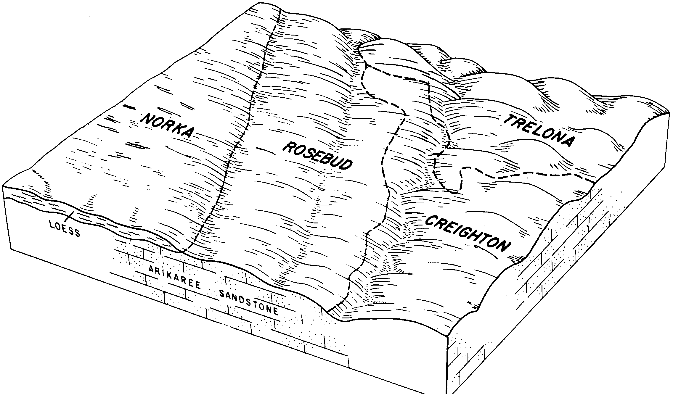
Rosebud-Hargreave fine sandy loams, 0 to 6 percent slopes | 23B | 6102 | 104868 | 3j3v | wy715 | 1974 | 1:20000 |
Rosebud-Trelona fine sandy loams, 6 to 10 percent slopes | 24C | 5016 | 104871 | 3j3y | wy715 | 1974 | 1:20000 |
Rosebud-Trelona fine sandy loams, 0 to 6 percent slopes | 24B | 3363 | 104870 | 3j3x | wy715 | 1974 | 1:20000 |
Rosebud-Hargreave fine sandy loams, 6 to 10 percent slopes | 23C | 3030 | 104869 | 3j3w | wy715 | 1974 | 1:20000 |
Rosebud-Trelona fine sandy loams, 10 to 20 percent slopes | 24D | 305 | 104872 | 3j3z | wy715 | 1974 | 1:20000 |