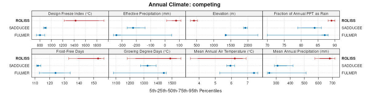
| Roliss loam, 0 to 2 percent slopes | I53A | 3420 | 2798040 | 307dm | mn007 | 1991 | 1:24000 |
Roliss loam, des moines, 0 to 2 percent slopes | B204A | 211 | 2474945 | 2p2cy | mn007 | 1991 | 1:24000 |
Roliss loam, very poorly drained, 0 to 1 percent slopes | I54A | 1 | 2798074 | 307dp | mn027 | 1980 | 1:20000 |
Roliss loam, 0 to 2 percent slopes | 582 | 9157 | 430549 | 2w8fb | mn029 | 1993 | 1:20000 |
Roliss loam, 0 to 2 percent slopes | I53A | 3979 | 2798163 | 307dm | mn029 | 1993 | 1:20000 |
Roliss loam, des moines, 0 to 2 percent slopes | B204A | 3280 | 2474811 | 2p27m | mn029 | 1993 | 1:20000 |
Roliss loam, 0 to 2 percent slopes | I53A | 18005 | 2798179 | 307dm | mn051 | 1974 | 1:20000 |
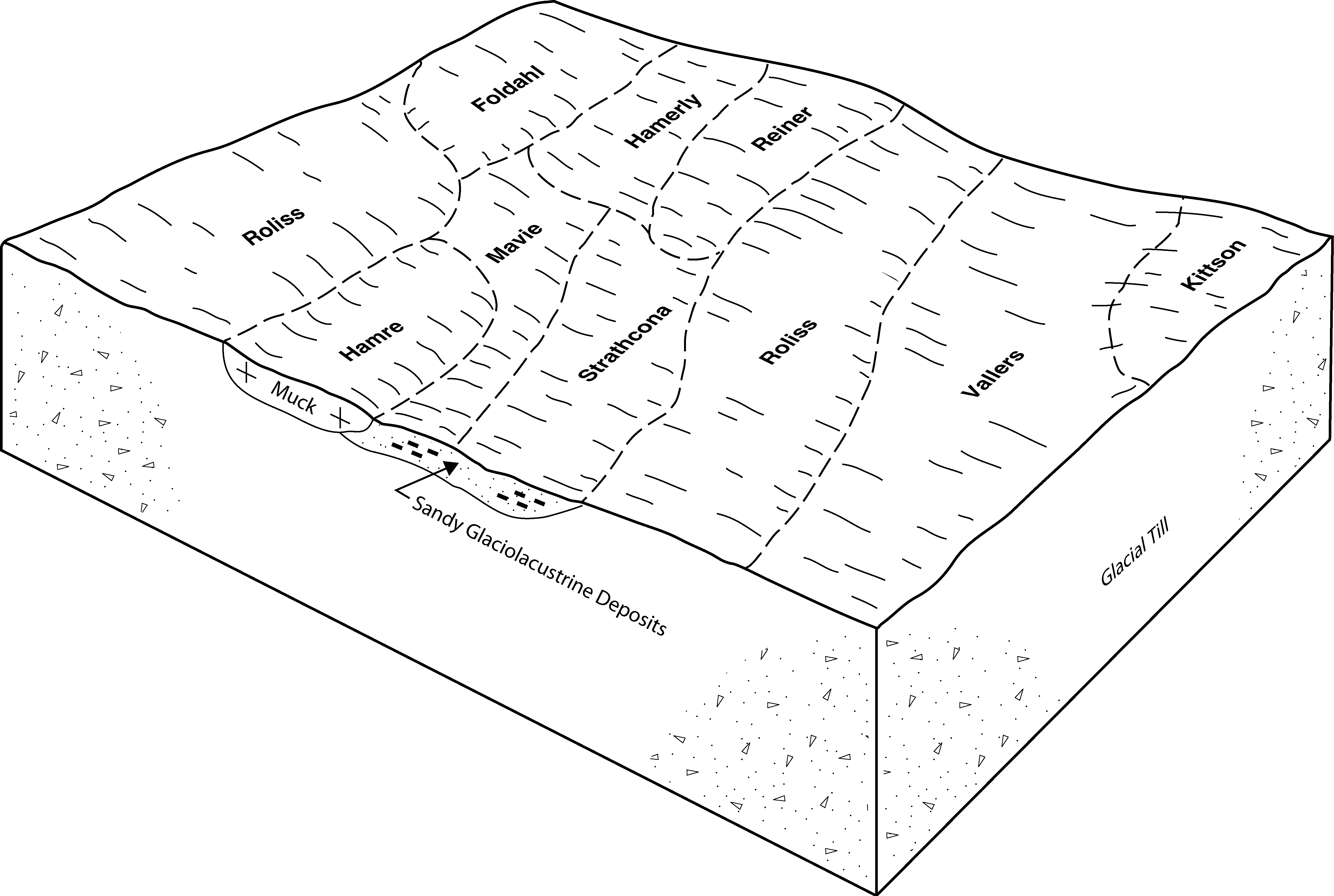
Roliss-Vallers loams, 0 to 1 percent slopes | I707A | 3052 | 2798216 | 307dr | mn051 | 1974 | 1:20000 |
Roliss complex, 0 to 1 percent slopes | I708A | 2137 | 2798215 | 307dn | mn051 | 1974 | 1:20000 |
Roliss clay loam, 0 to 1 percent slopes | I393A | 60 | 2798190 | 307dl | mn051 | 1974 | 1:20000 |
Roliss clay loam | 582 | 6611 | 398903 | fd2v | mn077 | 1989 | 1:24000 |
Roliss loam, depressional | 387 | 4885 | 398879 | fd22 | mn077 | 1989 | 1:24000 |
Lakepark-Roliss-Parnell, depressional, complex, 0 to 3 percent slopes | J107A | 21065 | 1542319 | 1nrx7 | mn081 | 2007 | 1:12000 |
Lakepark-Roliss-Parnell, depressional, complex, 0 to 3 percent slopes | J107A | 19348 | 1542324 | 1nrxd | mn083 | 2008 | 1:12000 |
Roliss loam, 0 to 2 percent slopes | I53A | 39042 | 2798929 | 307dm | mn089 | 1994 | 1:20000 |
Roliss-Vallers loams, 0 to 1 percent slopes | I707A | 33600 | 2799023 | 307dr | mn089 | 1994 | 1:20000 |
Roliss loam, very poorly drained, 0 to 1 percent slopes | I54A | 3142 | 2798930 | 307dp | mn089 | 1994 | 1:20000 |
Roliss loam, very poorly drained, dense till, 0 to 1 percent slopes | I706A | 481 | 2799022 | 2sw8n | mn089 | 1994 | 1:20000 |
Roliss loam, dense till, 0 to 1 percent slopes | I705A | 416 | 2799021 | 2sw8m | mn089 | 1994 | 1:20000 |
Lakepark-Roliss-Parnell, depressional, complex, 0 to 3 percent slopes | J107A | 18098 | 1542327 | 1nrxh | mn101 | 2008 | 1:12000 |
Roliss loam, very poorly drained, 0 to 1 percent slopes | I54A | 1002 | 2799052 | 307dp | mn107 | 1970 | 1:20000 |
Roliss loam, 0 to 2 percent slopes | I53A | 867 | 2799051 | 307dm | mn107 | 1970 | 1:20000 |
Roliss silt loam, 0 to 1 percent slopes | I853A | 615 | 2799127 | 307dq | mn107 | 1970 | 1:20000 |
Roliss loam, 0 to 2 percent slopes | 1240 | 2686 | 435579 | 2w8fb | mn111 | 1996 | 1:20000 |
Roliss clay loam, 0 to 1 percent slopes | I393A | 1239 | 2799144 | 307dl | mn111 | 1996 | 1:20000 |
Roliss loam, 0 to 2 percent slopes | I53A | 17754 | 2799200 | 307dm | mn113 | 2003 | 1:12000 |
Roliss loam, very poorly drained, 0 to 1 percent slopes | I54A | 159 | 2799201 | 307dp | mn113 | 2003 | 1:12000 |
Roliss loam, des moines, 0 to 2 percent slopes | B204A | 85 | 681020 | qvnd | mn113 | 2003 | 1:12000 |
Lakepark-Roliss-Parnell, depressional, complex, 0 to 3 percent slopes | J107A | 2819 | 1481610 | 1lqqw | mn117 | 2005 | 1:12000 |
Roliss loam, 0 to 2 percent slopes | I53A | 3540 | 2799671 | 307dm | mn119 | 1996 | 1:20000 |
Roliss loam, 0 to 2 percent slopes | 582 | 3086 | 352280 | 2w8fb | mn119 | 1996 | 1:20000 |
Roliss loam, depressional | 387 | 902 | 352244 | ctjq | mn119 | 1996 | 1:20000 |
Roliss loam, very poorly drained, 0 to 1 percent slopes | I54A | 598 | 2799672 | 307dp | mn119 | 1996 | 1:20000 |
Roliss silt loam, 0 to 1 percent slopes | I853A | 5 | 2799746 | 307dq | mn119 | 1996 | 1:20000 |
Roliss loam, 0 to 2 percent slopes | Ca | 3050 | 401326 | 2w8fb | mn121 | 1968 | 1:20000 |
Roliss loam, 0 to 2 percent slopes | I53A | 4341 | 2799800 | 307dm | mn125 | 2001 | 1:12000 |
Roliss loam, very poorly drained, 0 to 1 percent slopes | I54A | 799 | 2799801 | 307dp | mn125 | 2001 | 1:12000 |
Roliss loam, mlra 88, 0 to 2 percent slopes | B204A | 50 | 623358 | nxnb | mn125 | 2001 | 1:12000 |
Roliss loam, 0 to 2 percent slopes | 582 | 8048 | 394892 | f7xg | mn135 | 1999 | 1:24000 |
Roliss loam, dense till, 0 to 1 percent slopes | I705A | 2175 | 2799898 | 2sw8m | mn135 | 1999 | 1:24000 |
Roliss loam, depressional, 0 to 1 percent slopes | 387 | 532 | 394858 | f7wc | mn135 | 1999 | 1:24000 |
Roliss loam, 0 to 2 percent slopes | 582 | 23492 | 428166 | 2w8fb | mn145 | 1980 | 1:15840 |
Roliss loam, 0 to 2 percent slopes | 582 | 7433 | 428565 | 2w8fb | mn153 | 1985 | 1:20000 |
Roliss clay loam, 0 to 1 percent slopes | I393A | 1297 | 2799943 | 307dl | mn155 | 1986 | 1:20000 |
Roliss loam, 0 to 2 percent slopes | I53A | 78 | 2799934 | 307dm | mn155 | 1986 | 1:20000 |
Roliss clay loam, 0 to 1 percent slopes | I393A | 698 | 2800009 | 307dl | mn167 | 1985 | 1:20000 |
Roliss loam, 0 to 2 percent slopes | 582 | 175 | 357444 | 2w8fb | mn167 | 1985 | 1:20000 |
Lakepark-Roliss-Parnell, depressional, complex, 0 to 3 percent slopes | J107A | 2381 | 1542330 | 1nrxl | mn173 | 1979 | 1:20000 |
Roliss silt loam, 0 to 1 percent slopes | F10A | 6251 | 2587505 | 2q3wb | nd019 | 1987 | 1:20000 |
Roliss clay loam, 0 to 1 percent slopes | I393A | 40 | 2643101 | 307dl | nd019 | 1987 | 1:20000 |
Roliss clay loam, 0 to 1 percent slopes | I393A | 563 | 2641128 | 307dl | nd077 | 2005 | 1:12000 |
Roliss clay loam, 0 to 1 percent slopes | I393A | 2 | 2800182 | 307dl | sd109 | 1977 | 1:20000 |


