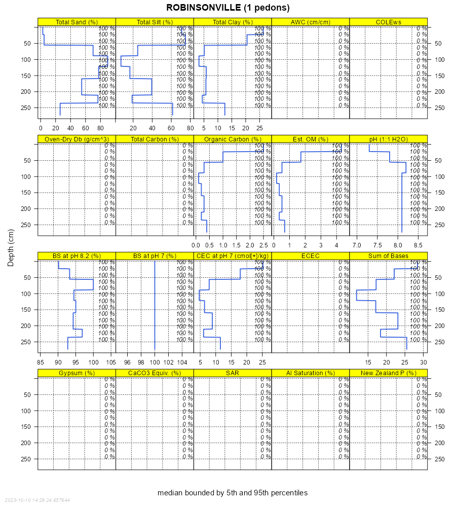
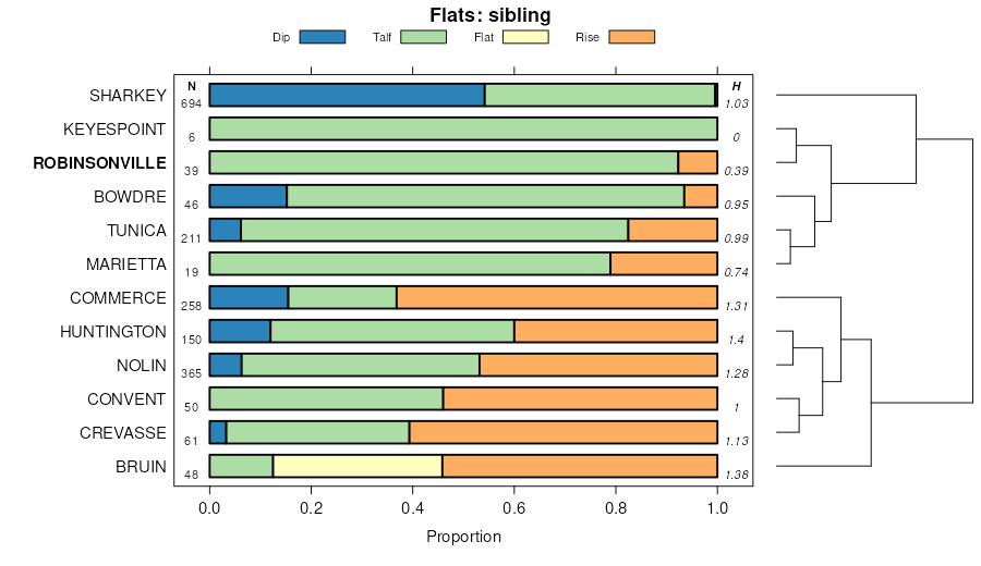
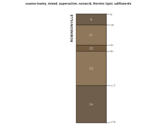
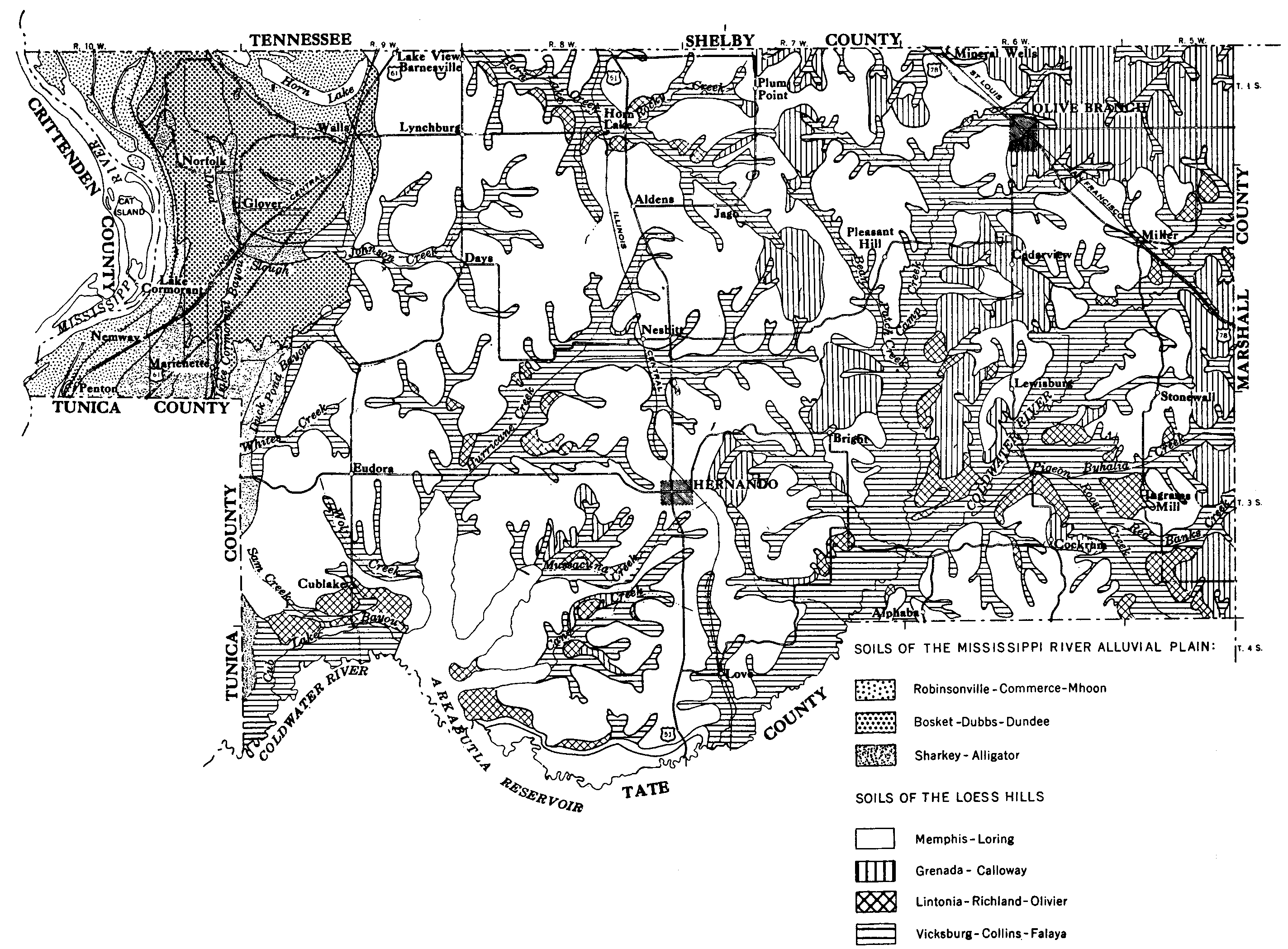
Official Series Description


Lab Data Summary

Aggregate lab data for the ROBINSONVILLE soil series. This aggregation is based on all pedons with a current taxon name of ROBINSONVILLE, and applied along 1-cm thick depth slices. Solid lines are the slice-wise median, bounded on either side by the interval defined by the slice-wise 5th and 95th percentiles. The median is the value that splits the data in half. Five percent of the data are less than the 5th percentile, and five percent of the data are greater than the 95th percentile. Values along the right hand side y-axis describe the proportion of pedon data that contribute to aggregate values at this depth. For example, a value of "90%" at 25cm means that 90% of the pedons correlated to ROBINSONVILLE were used in the calculation. Source: KSSL snapshot . Methods used to assemble the KSSL snapshot used by SoilWeb / SDE

Click the image to view it full size.

Pedons used in the lab summary:

MLRALab IDPedon IDTaxonnameCINSSL / NASIS ReportsLink To SoilWeb GMap
131AM05143042005MO14304ROBINSONVILLE4Primary | Supplementary | Taxonomy | Pedon | Water Retention | Correlation | Andic Soil Properties36.5333333,-89.4

Water Balance

Monthly water balance estimated using a leaky-bucket style model for the ROBINSONVILLE soil series. Monthly precipitation (PPT) and potential evapotranspiration (PET) have been estimated from the 50th percentile of gridded values (PRISM 1981-2010) overlapping with the extent of SSURGO map units containing each series as a major component. Monthly PET values were estimated using the method of Thornthwaite (1948). These (and other) climatic parameters are calculated with each SSURGO refresh and provided by the fetchOSD function of the soilDB package. Representative water storage values (“AWC” in the figures) were derived from SSURGO by taking the 50th percentile of profile-total water storage (sum[awc_r * horizon thickness]) for each soil series. Note that this representation of “water storage” is based on the average ability of most plants to extract soil water between 15 bar (“permanent wilting point”) and 1/3 bar (“field capacity”) matric potential. Soil moisture state can be roughly interpreted as “dry” when storage is depleted, “moist” when storage is between 0mm and AWC, and “wet” when there is a surplus. Clearly there are a lot of assumptions baked into this kind of monthly water balance. This is still a work in progress.

Click the image to view it full size.


Click the image to view it full size.

Sibling Summary

Siblings are those soil series that occur together in map units, in this case with the ROBINSONVILLE series. Sketches are arranged according to their subgroup-level taxonomic structure. Source: SSURGO snapshot , parsed OSD records and snapshot of SC database .

Click the image to view it full size.

Select annual climate data summaries for the ROBINSONVILLE series and siblings. Series are sorted according to hierarchical clustering of median values. Source: SSURGO map unit geometry and 1981-2010, 800m PRISM data .

Click the image to view it full size.

Geomorphic description summaries for the ROBINSONVILLE series and siblings. Series are sorted according to hierarchical clustering of proportions and relative hydrologic position within an idealized landform (e.g. top to bottom). Most soil series (SSURGO components) are associated with a hillslope position and one or more landform-specific positions: hills, mountain slopes, terraces, and/or flats. Proportions can be interpreted as an aggregate representation of geomorphic membership. The values printed to the left (number of component records) and right (Shannon entropy) of stacked bars can be used to judge the reliability of trends. Small Shannon entropy values suggest relatively consistent geomorphic association, while larger values suggest lack thereof. Source: SSURGO component records .

Click the image to view it full size.

Click the image to view it full size.

There are insufficient data to create the 3D mountains figure.

Click the image to view it full size.

Click the image to view it full size.

Competing Series

Soil series competing with ROBINSONVILLE share the same family level classification in Soil Taxonomy. Source: parsed OSD records and snapshot of the SC database .

Click the image to view it full size.

Select annual climate data summaries for the ROBINSONVILLE series and competing. Series are sorted according to hierarchical clustering of median values. Source: SSURGO map unit geometry and 1981-2010, 800m PRISM data .

There are insufficient data to create the annual climate figure.

Geomorphic description summaries for the ROBINSONVILLE series and competing. Series are sorted according to hierarchical clustering of proportions and relative hydrologic position within an idealized landform (e.g. top to bottom). Proportions can be interpreted as an aggregate representation of geomorphic membership. Most soil series (SSURGO components) are associated with a hillslope position and one or more landform-specific positions: hills, mountain slopes, terraces, and/or flats. The values printed to the left (number of component records) and right (Shannon entropy) of stacked bars can be used to judge the reliability of trends. Shannon entropy values close to 0 represent soil series with relatively consistent geomorphic association, while values close to 1 suggest lack thereof. Source: SSURGO component records .

There are insufficient data to create the 2D hillslope position figure.

There are insufficient data to create the 3D hills figure.

There are insufficient data to create the 3D mountains figure.

There are insufficient data to create the 3D terrace figure.

There are insufficient data to create the 3D flats position figure.

Soil series sharing subgroup-level classification with ROBINSONVILLE, arranged according to family differentiae. Hovering over a series name will print full classification and a small sketch from the OSD. Source: snapshot of SC database .

Block Diagrams

Click a link below to display the diagram. Note that these diagrams may be from multiple survey areas.

  1. KY-2012-01-27-18 | Carlisle and Hickman Counties - July 1997

    Relationship of soils to topography and underlying material in the Openlake-Commerce-Bardwell general soil map unit in Carlisle County (Soil Survey of Carlisle and Hickman Counties, Kentucky; July 1997).

  2. MS-2012-04-26-09 | De Soto County - September 1959

    Soil associations in De Soto County (Soil Survey of De Soto County, Mississippi; September 1959).

  3. MS-2012-04-27-09 | Tunica County - May 1956

    Soil association map of Tunica County, Miss (Soil Survey of Tunica County, Mississippi; May 1956).

  4. MS-2012-04-27-10 | Bolivar County - December 1958

    Soil associations in Bolivar County: 1. Alluvial soils; 2. Commerce-Robinsonville-Crevasse; 3. Forestdale-Dundee-Bosket; 4. Brittain-Pearson-Dexter; 5. Dowling-Alligator-Sharkey (Soil Survey of Bolivar County, Mississippi; December 1958).

  5. OK-2012-02-17-47 | Sequoyah County - June 1970

    Typical pattern of soils in associations 2 and 4 (Soil Survey of Sequoyah County, Oklahoma; June 1970).

  6. TN-2012-03-19-10 | Lauderdale County - June 1990

    Typical pattern of soils and underlying material in the Commerce-Robinsonville and Sharkey-Keyespoint-Openlake general soil map units on the Mississippi River flood plain (Soil Survey of Lauderdale County, TN; 1990).

Map Units

Map units containing ROBINSONVILLE as a major component. Limited to 250 records.

Map Unit Name Symbol Map Unit Area (ac) Map Unit Key National Map Unit Symbol Soil Survey Area Publication Date Map Scale
Robinsonville loam, gently undulatingRoU2505565281lz6war01719641:20000
Robinsonville very fine sandy loamRn9040564176ly27ar03519701:20000
Robinsonville very fine sandy loam, frequently floodedRo2980564177ly28ar03519701:20000
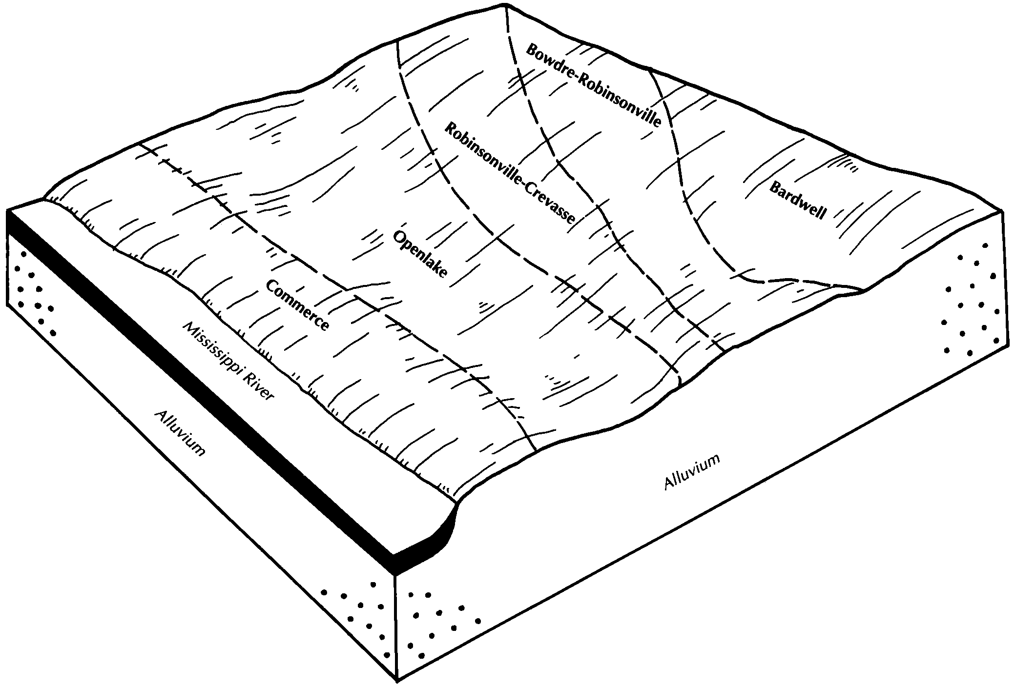
Bowdre, Desha, and Robinsonville soils, gently undulatingBdU1440564186ly2kar04119681:20000
Robinsonville fine sandy loamRo5310564106lxzzar07719741:20000
Robinsonville soils, frequently floodedRs1960564107ly00ar07719741:20000
Robinsonville fine sandy loamRo4480564250ly4mar10719711:20000
Robinsonville soils, frequently floodedRs2850564251ly4nar10719711:20000
Robinsonville fine sandy loam, frequently flooded281150566655m0n6ar14519801:20000
Robinsonville fine sandy loam, frequently floodedRo1040549145lffcky05519851:20000
Robinsonville-Huntington complex, frequently floodedRu468549146lffdky05519851:20000
Robinsonville fine sandy loam, 0 to 3 percent slopes, occasionally floodedRc993655048pzmlky07520021:12000
Robinsonville fine sandy loam, 0 to 3 percent slopes, frequently floodedRf903655027pzlxky07520021:12000
Robinsonville fine sandy loam, 0 to 3 percent slopes, protectedRb339655028pzlyky07520021:12000
Robinsonville fine sandy loam, natural levee, 8 to 25 percent slopes, occasionally floodedRmD133655029pzlzky07520021:12000
Robinsonville fine sandy loamRf1239549782lg2xky16919651:15840
Robinsonville-Crevasse complex, frequently floodedRc3542570540m4pjky61119911:20000
Bowdre-Robinsonville complex, frequently floodedBr1660570517m4nsky61119911:20000
Robinsonville fine sandy loamRo1609549530lftsky63519781:20000
Huntington-Robinsonville complexHu1477549509lft3ky63519781:20000
Convent and Robinsonville soils, frequently floodedCRC4521577013mcfbla03320071:24000
Convent and Robinsonville soils, frequently floodedCX235514513751kq8kla04719751:24000
Cancienne and Carville soils, undulating, frequently floodedCg125914513661kq88la04719751:24000
Robinsonville and Commerce soils, occasionally floodedRE3103416784321tbjzla07719801:24000
Robinsonville and Commerce soils, occasionally floodedRE1049213973841hx2xla12120041:24000
Robinsonville and Convent soils, occasionally floodedRC993417256121vxmxla12520021:24000
Robinsonville very fine sandy loamRo2301567426m1g2ms00119661:15840
Robinsonville fine sandy loamRa1287567508m1jqms01119561:20000
Commerce-Robinsonville-Crevasse soilsCg1123567479m1hsms01119561:20000
Robinsonville and Marietta soilsRm3557331903c4ckms01719691:20000
Crevasse, Commerce, and Robinsonville soils, (bruno, commerce and robinsonville)Cr6255567578m1lzms02119611:20000
Robinsonville very fine sandy loam, 0 to 3 percent slopesRa2231567655m1pgms02719561:24000
Robinsonville-crevasse soils, 0 to 3 percent slopes (robinsonville, bruno)Rc1813567657m1pjms02719561:24000
Robinsonville-crevasse soils, 3 to 7 percent slopes (robinsonville, bruno)Rd386567658m1pkms02719561:24000
Robinsonville very fine sandy loam, 3 to 7 percent slopesRb175567656m1phms02719561:24000
Robinsonville very fine sandy loam, nearly level phaseRf190567790m1ttms03319551:24000
Robinsonville very fine sandy loam, 0 to 2 percent slopesRo1450568055m23cms05519601:20000
Robinsonville very fine sandy loam, 2 to 5 percent slopesRs230568056m23dms05519601:20000
Bruin-Robinsonville associationBR3639568068m23sms06319761:20000
Robinsonville very fine sandy loamRb752568095m24nms06319761:20000
Robinsonville soilsRo2201333040c5k7ms08119681:20000
Robinsonville sandy loamRo4254333729c68gms11519691:20000
Robinsonville very fine sandy loam, 0 to 2 percent slopesRo330568433m2hkms12519601:20000
Robinsonville very fine sandy loam, 0 to 2 percent slopes261342717159691vllvms14320061:24000
Commerce and Robinsonville very fine sandy loams, land leveled380181317160751vlq8ms14320061:24000
Robinsonville very fine sandy loam, 0 to 2 percent slopes, frequently flooded26274017159701vllwms14320061:24000
Commerce, Robinsonville, and Crevasse soils, frequently flooded (commerce, robinsonville, bruno)CrC3753126934572rp1yms14919621:15840
Robinsonville loamRo352568710m2shms14919621:15840
Robinsonville very fine sandy loam, 0 to 2 percent slopesRo1510568765m2v8ms15119591:20000
Robinsonville silt loam, frequently flooded234202571086m584ms15720061:24000
Robinsonville loamRs4028566813m0t9tn04519631:15840
Robinsonville fine sandy loamRo2547566812m0t8tn04519631:15840
Robinsonville fine sandy loam, frequently floodedRm4708567132m14ltn09519661:20000
Robinsonville silt loam, occasionally floodedRc7409567181m165tn09719851:24000
Robinsonville fine sandy loam, occasionally floodedRb5765567180m164tn09719851:24000
Robinsonville silty clay loam, overwash, occasionally floodedRd2082567182m166tn09719851:24000
Robinsonville silt loamRn5181567320m1bntn15719661:15840
Robinsonville fine sandy loamRb1681567319m1bmtn15719661:15840
Robinsonville fine sandy loam, rarely floodedRo5313567356m1cttn16719891:24000
Robinsonville silt loam, occasionally floodedRb3888567355m1cstn16719891:24000

Map of Series Extent

Approximate geographic distribution of the ROBINSONVILLE soil series. To learn more about how this distribution was mapped, or to compare this soil series extent to others, use the Series Extent Explorer (SEE) application. Source: generalization of SSURGO geometry .