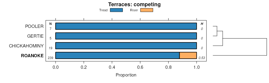
| Roanoke complex | Ro | 7570 | 328086 | c0df | al001 | 1972 | 1:20000 |
Roanoke silt loam | Ro | 1930 | 122793 | 43s2 | al027 | 1971 | 1:20000 |
Roanoke silt loam | Rd | 5407 | 329287 | c1n5 | al051 | 1948 | 1:20000 |
Roanoke silt loam, 0 to 1 percent slopes, occasionally flooded | RyA | 1391 | 330490 | c2wz | al087 | 1997 | 1:24000 |
Roanoke silt loam, 0 to 1 percent slope, occasionally flooded | Rb | 8091 | 330950 | 2z476 | al101 | 1958 | 1:20000 |
Roanoke silt loam | Ra | 245 | 122874 | 43vp | al111 | 1965 | 1:15840 |
Roanoke silt loam | Ron | 1075 | 124219 | 4582 | ga067 | 1969 | 1:15840 |
Roanoke fine sandy loam | Roa | 140 | 124548 | 45lp | ga137 | 1960 | 1:20000 |
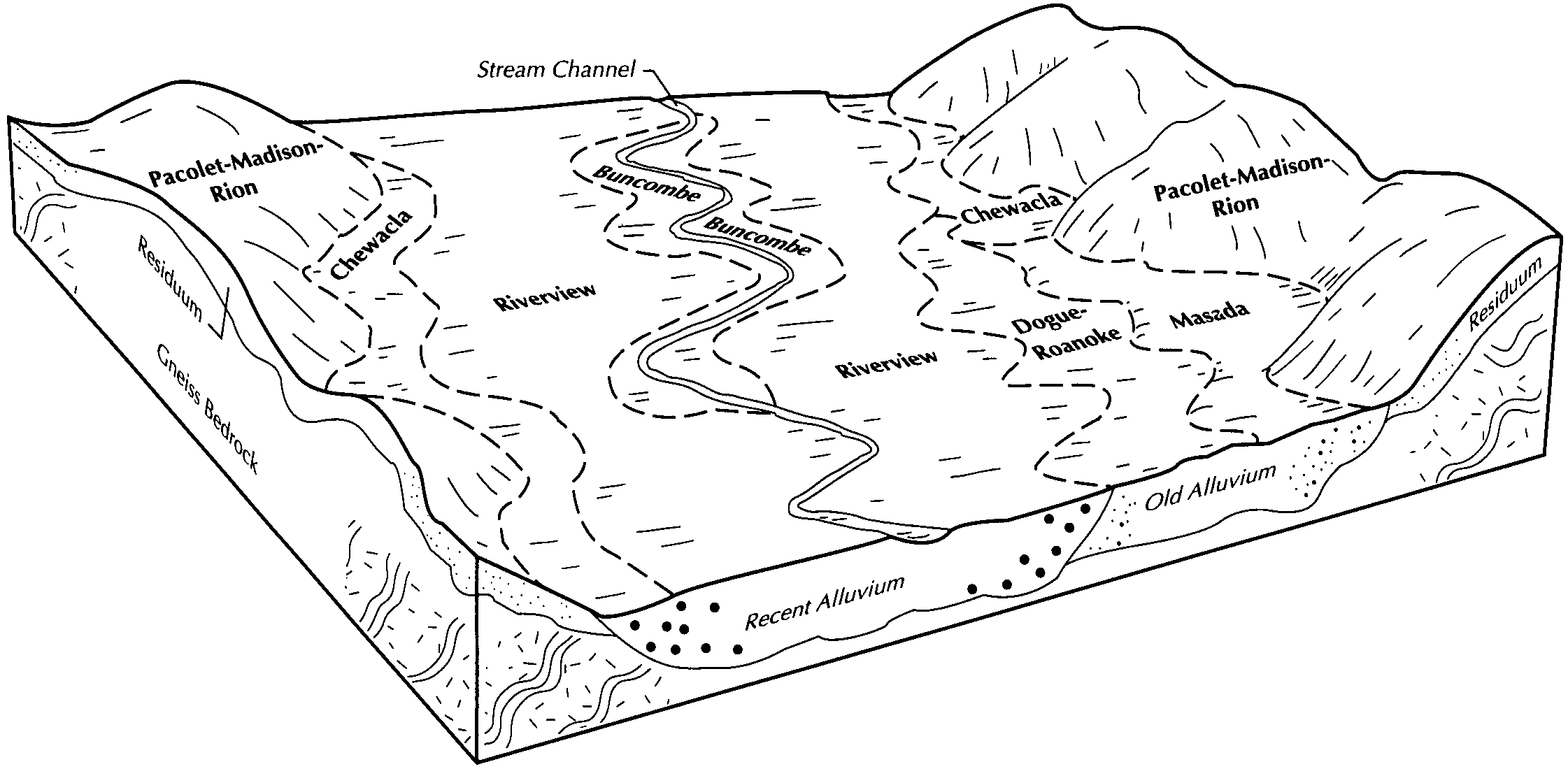
Chewacla-Roanoke complex, 0 to 1 percent slopes, ponded | Cr | 1095 | 126946 | 4831 | ga159 | 1997 | 1:24000 |
Roanoke silt loam, 0 to 2 percent slopes, frequently flooded | Rk | 370 | 126977 | 4841 | ga159 | 1997 | 1:24000 |
Roanoke silt loam | Ron | 915 | 124740 | 45sw | ga199 | 1960 | 1:15840 |
Roanoke loam | Rr | 1980 | 324904 | bx2s | ga245 | 1979 | 1:15840 |
Wehadkee and Roanoke silty clay loams | Wer | 3795 | 124992 | 4620 | ga255 | 1962 | 1:15840 |
Roanoke and Augusta sandy loams | Rol | 320 | 124990 | 461y | ga255 | 1962 | 1:15840 |
Roanoke silt loam | Rn | 9985 | 531289 | ktvc | ga621 | 1975 | 1:20000 |
Roanoke silt loam | Ro | 1730 | 125575 | 46nt | ga628 | 1977 | 1:20000 |
Roanoke silty clay loam, overwash | Ro | 3445 | 125629 | 46qk | ga629 | 1976 | 1:20000 |
Roanoke silt loam, occasionally flooded | Ro | 490 | 127119 | 488m | ga645 | 1995 | 1:12000 |
Roanoke silt loam, frequently flooded | Rk | 2040 | 127381 | 48k2 | ga649 | 1992 | 1:12000 |
Roanoke loam, 0 to 2 percent slopes, rarely flooded | RoA | 168 | 114556 | 3v6c | nc007 | 1999 | 1:24000 |
Roanoke fine sandy loam | Ro | 44433 | 111599 | 3r3z | nc013 | 1986 | 1:24000 |
Roanoke fine sandy loam, frequently flooded | Ro | 31720 | 111459 | 3qzg | nc015 | 1984 | 1:24000 |
Roanoke loam | Ro | 10451 | 115513 | 3w67 | nc017 | 1983 | 1:24000 |
Roanoke silt loam, 0 to 2 percent slopes | RoA | 13089 | 111791 | 3rb5 | nc029 | 1988 | 1:24000 |
Roanoke loam | Ro | 1519 | 115620 | 3w9p | nc031 | 1984 | 1:24000 |
Roanoke loam, 0 to 2 percent slopes, occasionally flooded | RkA | 654 | 2431428 | 2mm35 | nc035 | 1969 | 1:15840 |
Roanoke silt loam | Ro | 20111 | 811399 | w7b5 | nc041 | 1982 | 1:24000 |
Roanoke fine sandy loam | Ro | 1608 | 115777 | 3wgr | nc049 | 1984 | 1:24000 |
Roanoke and Warne soils, 0 to 2 percent slopes, occasionally flooded | Ro | 17977 | 811142 | w71w | nc051 | 1981 | 1:24000 |
Roanoke-Urban land complex | Ru | 1293 | 811143 | w71x | nc051 | 1981 | 1:24000 |
Roanoke fine sandy loam | Ro | 28496 | 112128 | 3rp1 | nc053 | 1980 | 1:20000 |
Roanoke loam, 0 to 2 percent slopes, occasionally flooded | RwA | 151 | 112287 | 3rv5 | nc059 | 1988 | 1:24000 |
Roanoke silt loam, 0 to 2 percent slopes, occasionally flooded | Ro | 1090 | 2450765 | 2n86y | nc063 | 1971 | 1:15840 |
Roanoke loam | Ro | 30409 | 1015689 | 132x5 | nc065 | 1976 | 1:20000 |
Roanoke-Warne complex, 0 to 3 percent slopes, occasionally flooded | RoA | 1259 | 2441663 | 2myrb | nc069 | 1997 | 1:24000 |
Roanoke loam, 0 to 2 percent slopes | RoA | 2668 | 115948 | 3wn8 | nc073 | 1990 | 1:24000 |
Roanoke loam, 0 to 2 percent slopes, occasionally flooded | RoA | 12558 | 113058 | 3sn1 | nc083 | 1995 | 1:24000 |
Roanoke loam, occasionally flooded | Ro | 15556 | 113132 | 3sqf | nc085 | 1984 | 1:24000 |
Roanoke loam | Ro | 1852 | 113172 | 3srq | nc091 | 1981 | 1:24000 |
Roanoke loam, 0 to 2 percent slopes, occasionally flooded | Ro | 3157 | 113555 | 3t52 | nc101 | 1986 | 1:24000 |
Roanoke silt loam, 0 to 2 percent slopes, occasionally flooded | Ro | 1025 | 2442020 | 2mz3v | nc105 | 1982 | 1:24000 |
Roanoke loam, frequently flooded | Ro | 1569 | 111139 | 3qn4 | nc117 | 1985 | 1:24000 |
Roanoke silt loam, 0 to 2 percent slopes, occasionally flooded | Ro | 2778 | 114061 | 3tpd | nc131 | 1988 | 1:24000 |
Roanoke silt loam | Ro | 44011 | 811436 | w7cc | nc143 | 1982 | 1:24000 |
Roanoke silt loam | Ro | 10574 | 114344 | 3tzj | nc147 | 1969 | 1:15840 |
Dorian-Roanoke complex, 0 to 6 percent slopes, rarely flooded | DoB | 3206 | 2441664 | 2myrc | nc149 | 1992 | 1:24000 |
Roanoke loam | Ro | 642 | 115072 | 3vr0 | nc163 | 1982 | 1:24000 |
Roanoke loam, rarely flooded | Ro | 1882 | 115258 | 3vy0 | nc177 | 1985 | 1:24000 |
Roanoke loam, 0 to 2 percent slopes, occasionally flooded | RoA | 314 | 2538641 | 2qqm1 | nc183 | 1966 | 1:24000 |
Roanoke loam | Ro | 16345 | 116216 | 3wxx | nc187 | 1979 | 1:24000 |
Roanoke loam, 0 to 2 percent slopes, occasionally flooded | Ro | 1095 | 116445 | 3x59 | nc195 | 1980 | 1:24000 |
Roanoke loam | Rd | 548 | 525197 | kmhv | tn059 | 1954 | 1:15840 |
Roanoke fine sandy loam, 0 to 2 percent slopes, rarely flooded | 17A | 2007 | 118110 | 3yx0 | va007 | 1994 | 1:24000 |
Tomotley-Roanoke complex, 0 to 2 percent slopes, rarely flooded | 26A | 6235 | 121051 | 41yw | va033 | 1996 | 1:24000 |
Roanoke loam, 0 to 2 percent slopes, ponded | 19A | 665 | 121045 | 41yp | va033 | 1996 | 1:24000 |
Roanoke silt loam, 0 to 2 percent slopes | 40A | 2233 | 117901 | 3yp8 | va036 | 1993 | 1:24000 |
Roanoke silt loam | Ro | 1256 | 118778 | 3zlk | va037 | 1970 | 1:15840 |
Roanoke loam | 137 | 1467 | 118827 | 3zn4 | va041 | 1974 | 1:15840 |
Roanoke silt loam | Rb | 154 | 121830 | 42s0 | va065 | 1950 | 1:15840 |
Roanoke silt loam | 33 | 271 | 119025 | 3zvj | va075 | 1976 | 1:15840 |
Roanoke loam, 0 to 2 percent slopes, frequently flooded | 31A | 28921 | 695368 | rbl7 | va081 | 1986 | 1:15840 |
Roanoke silt loam, 0 to 2 percent slopes, ponded | 32A | 11053 | 695369 | rbl8 | va081 | 1986 | 1:15840 |
Roanoke silt loam | Ro | 1403 | 119275 | 403l | va087 | 1973 | 1:15840 |
Roanoke loam, 0 to 2 percent slopes, rarely flooded | 13A | 676 | 118530 | 3zbk | va097 | 1995 | 1:24000 |
Roanoke silt loam, 0 to 2 percent slopes | 24A | 3357 | 694726 | r9xj | va101 | 1995 | 1:15840 |
Roanoke silt loam, local alluvium, 2 to 7 percent slopes | RoB | 1000 | 119412 | 4080 | va109 | 1972 | 1:15840 |
Roanoke silt loam | Rk | 236 | 517042 | kc0s | va113 | 1967 | 1:15840 |
Roanoke silt loam, 0 to 2 percent slopes | 31A | 1842 | 119687 | 40jw | va127 | 1985 | 1:15840 |
Roanoke silt loam | Ra | 363 | 120286 | 4156 | va147 | 1950 | 1:20000 |
Roanoke silt loam | Re | 135 | 517460 | kcg8 | va157 | 1958 | 1:20000 |
Roanoke loam, 0 to 2 percent slopes, occasionally flooded | 23A | 12830 | 705287 | rnx6 | va175 | 1996 | 1:24000 |
Roanoke silt loam, 0 to 2 percent slopes | Ro | 2470 | 120553 | 41ft | va179 | 1970 | 1:15840 |
Roanoke loam, 0 to 2 percent slopes, frequently flooded | 22A | 18426 | 1723102 | 1vv0y | va183 | 2006 | 1:24000 |
Roanoke silt loam, local alluvium | Ro | 425 | 120758 | 41nf | va631 | 1973 | 1:15840 |
Roanoke loam, 0 to 2 percent slopes, occasionally flooded | 16A | 26965 | 2481800 | 2p9j2 | va653 | 1991 | 1:24000 |
Roanoke silt loam, 0 to 2 percent slopes | 31A | 1808 | 140111 | 4psq | va760 | 2004 | 1:24000 |
Roanoke-Chewacla complex, 0 to 2 percent slopes, frequently flooded | 32A | 568 | 140026 | 4ppz | va760 | 2004 | 1:24000 |


