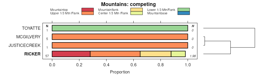
| Ricker-Saddleback association, very steep | RSE | 14527 | 285050 | 9km5 | me610 | 1992 | 1:20000 |
Surplus-Saddleback-Ricker association, strongly sloping, very stony | SSC | 2322 | 285055 | 9kmb | me610 | 1992 | 1:20000 |
Ricker-Rock outcrop complex, very steep | RRE | 2263 | 285049 | 9km4 | me610 | 1992 | 1:20000 |
Ricker-Saddleback-Rock outcrop complex, very hilly | RCE | 2475 | 285814 | 9ldt | me613 | 1987 | 1:20000 |
Saddleback-Ricker complex, steep | SAE | 1745 | 285822 | 9lf2 | me613 | 1987 | 1:20000 |
Saddleback-Ricker complex, moderately steep | SAD | 1579 | 285821 | 9lf1 | me613 | 1987 | 1:20000 |
Rock outcrop-Ricker complex, very hilly | RNE | 325 | 285815 | 9ldv | me613 | 1987 | 1:20000 |
Ricker-Rock outcrop complex, moderately steep | ROD | 4314 | 285360 | 9ky5 | me615 | 1994 | 1:24000 |
Saddleback-Ricker complex, steep, very stony | SRE | 1760 | 285362 | 9ky7 | me615 | 1994 | 1:24000 |
Saddleback-Ricker complex, moderately steep, very stony | SRD | 947 | 285361 | 9ky6 | me615 | 1994 | 1:24000 |
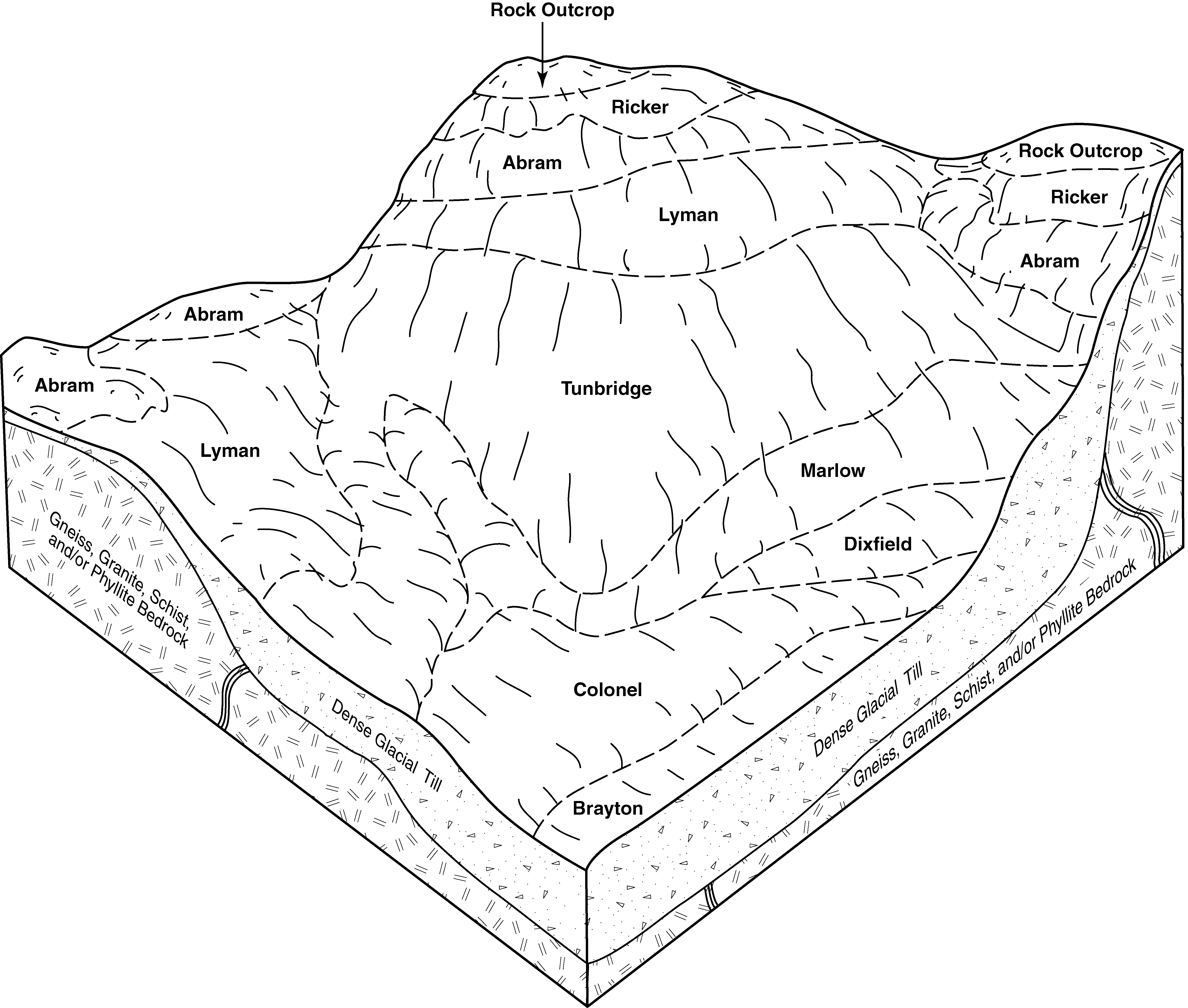
Naskeag-Abram-Ricker complex, 0 to 15 percent slopes, very stony | NAC | 14289 | 285607 | 9l64 | me617 | 2004 | 1:24000 |
Abram-Rock outcrop-Ricker complex, 15 to 80 percent slopes | ACE | 8156 | 285525 | 9l3h | me617 | 2004 | 1:24000 |
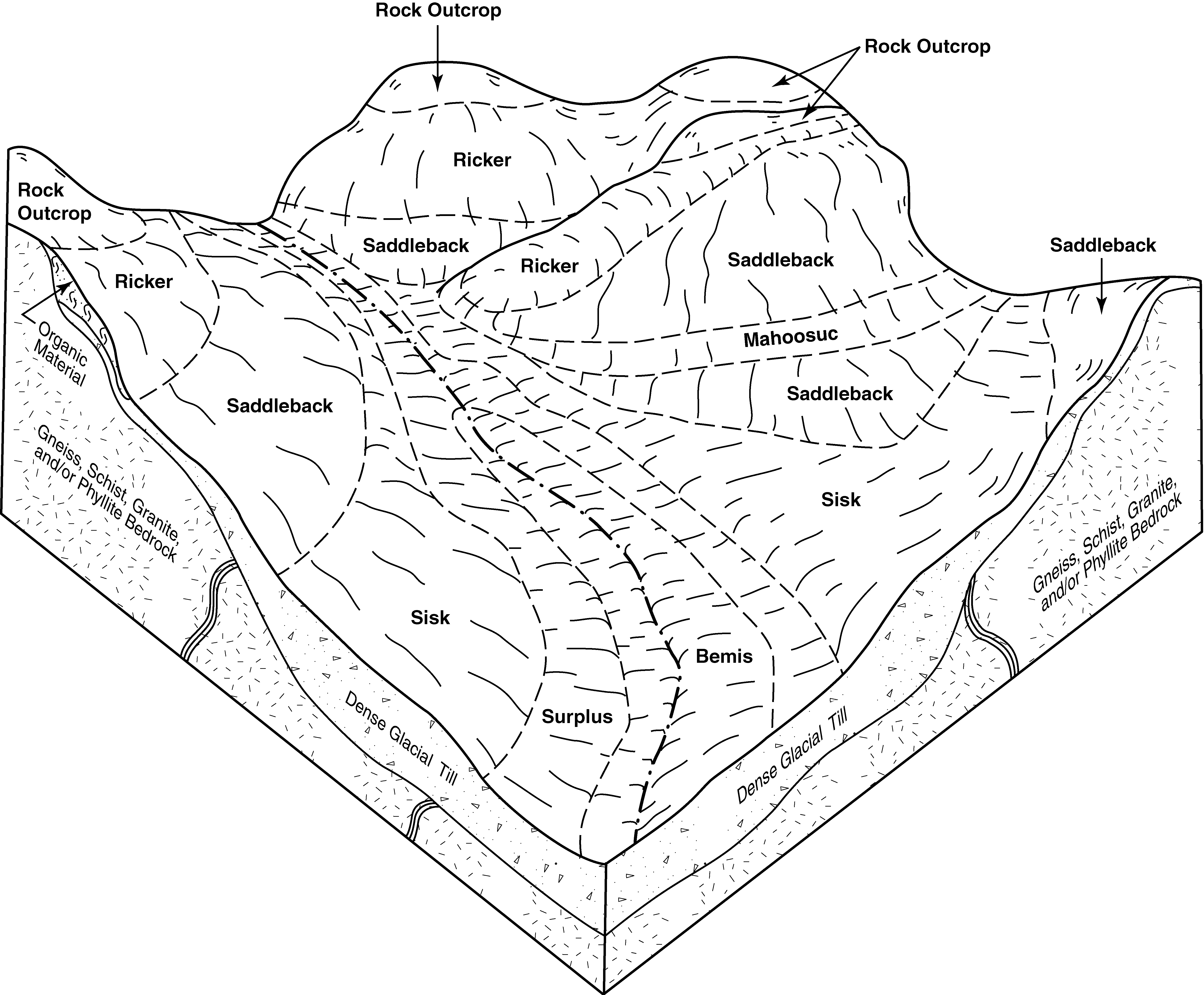
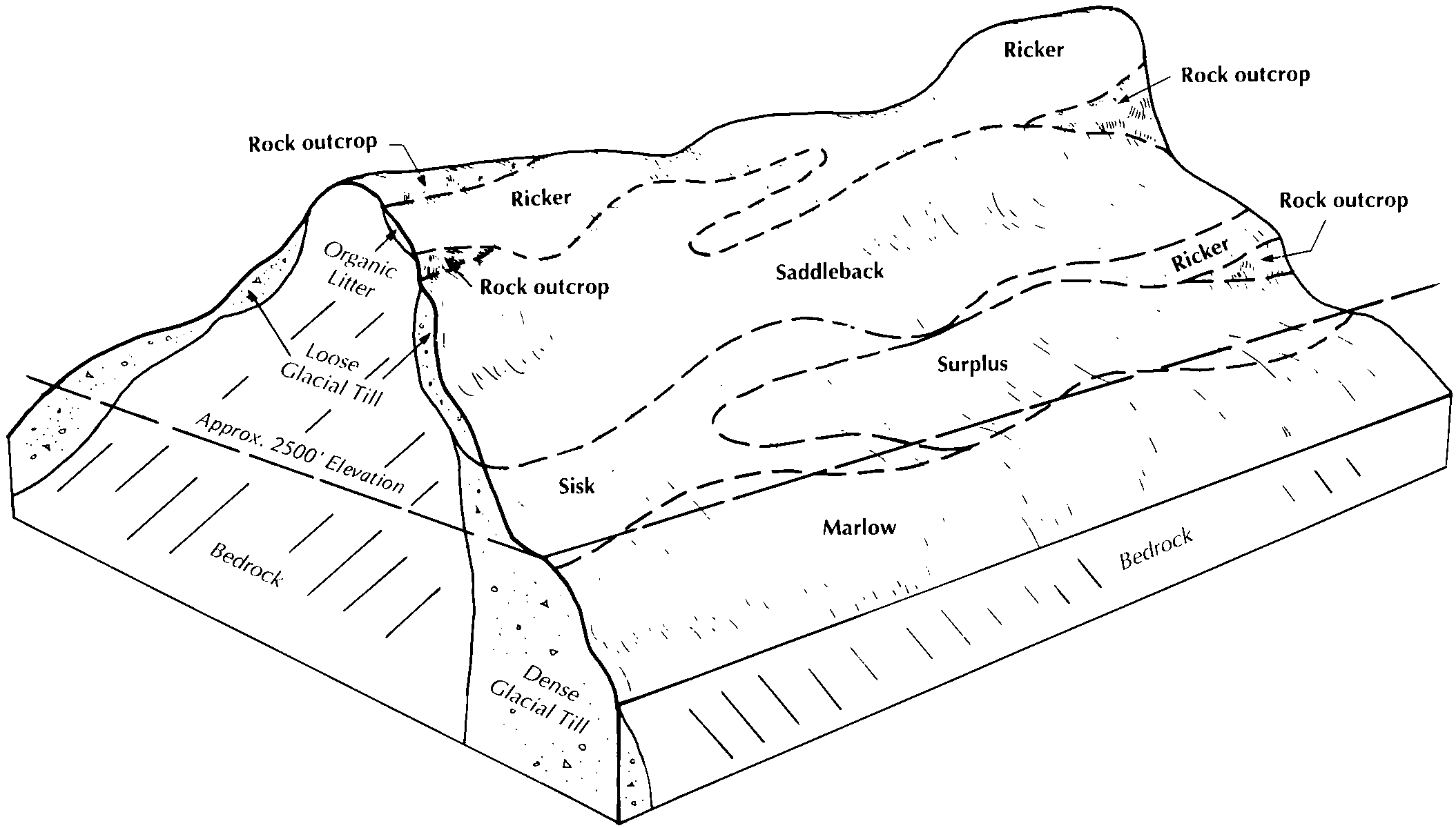
Saddleback-Ricker complex, 25 to 60 percent slopes | SRE | 34559 | 285645 | 9l7c | me619 | 2005 | 1:24000 |
Ricker-Saddleback-Rock outcrop complex, 20 to 60 percent slopes | RSE | 21359 | 285643 | 9l79 | me619 | 2005 | 1:24000 |
Saddleback-Ricker complex, 10 to 50 percent slopes | SRD | 18518 | 285644 | 9l7b | me619 | 2005 | 1:24000 |
Ricker-Rock outcrop complex, 3 to 80 percent slopes | RRF | 12613 | 285642 | 9l78 | me619 | 2005 | 1:24000 |
Rock outcrop-Ricker complex, 8 to 80 percent slopes | RTF | 7049 | 285647 | 9l7f | me619 | 2005 | 1:24000 |
Saddleback-Rock outcrop-Ricker complex, 15 to 60 percent slopes, extremely bouldery | SRE | 6570 | 2549933 | 2r0tn | me620 | 2011 | 1:24000 |
Ricker-Saddleback complex, 15 to 35 percent slopes, rubbly | RSE | 6253 | 2549935 | 2r0tq | me620 | 2011 | 1:24000 |
Rock outcrop- Ricker complex, 0 to 100 percent slopes, rubbly | RRF | 3065 | 2549936 | 2r0tr | me620 | 2011 | 1:24000 |
Saddleback-Ricker complex, 3 to 15 percent slopes, rubbly | SRC | 936 | 2549934 | 2r0tp | me620 | 2011 | 1:24000 |
Saddleback-Ricker-Rock outcrop complex, steep | 735E | 5414 | 281194 | 9fls | nh009 | 1986 | 1:24000 |
Saddleback-Glebe-Ricker association, steep, very stony | 750E | 18818 | 280592 | 9dzc | nh607 | 2000 | 1:24000 |
Saddleback-Glebe-Ricker association, moderately steep, very stony | 750D | 6051 | 280591 | 9dzb | nh607 | 2000 | 1:24000 |
Saddleback-Glebe-Ricker association, gently sloping, very stony | 750B | 2692 | 280590 | 9dz9 | nh607 | 2000 | 1:24000 |
Ricker-Rock outcrop complex, very steep | 835F | 1104 | 280646 | 9f13 | nh607 | 2000 | 1:24000 |
Ricker-Rock outcrop complex, strongly sloping | 835C | 112 | 280645 | 9f12 | nh607 | 2000 | 1:24000 |
Saddleback-Glebe-Ricker complex, 25 to 35 percent slopes, very stony | 836E | 60 | 280754 | 9f4l | nh607 | 2000 | 1:24000 |
Ricker-Rock outcrop complex, 25 to 35 percent slopes | 837E | 56 | 280751 | 9f4h | nh607 | 2000 | 1:24000 |
Saddleback-Glebe-Ricker complex, 8 to 15 percent slopes, very stony | 836C | 36 | 280753 | 9f4k | nh607 | 2000 | 1:24000 |
Saddleback-Glebe-Ricker complex, 15 to 25 percent slopes, very stony | 836D | 7 | 280752 | 9f4j | nh607 | 2000 | 1:24000 |
Rock outcrop-Ricker complex, gently sloping | RoB | 8387 | 290223 | 9r01 | ny019 | 1995 | 1:24000 |
Hogback-Ricker complex, 35 to 60 percent slopes, very rocky | 945F | 2850 | 290090 | 9qvr | ny019 | 1995 | 1:24000 |
Rockoutcrop-Ricker-Hogback complex, 35 to 60 percent slopes, very bouldery | 949F | 2425 | 290091 | 9qvs | ny019 | 1995 | 1:24000 |
Ricker-Skylight-Rockoutcrop complex, 35 to 70 percent slopes, very bouldery | 997F | 2026 | 290093 | 9qvv | ny019 | 1995 | 1:24000 |
Rawsonville-Borosaprists-Ricker complex, 0 to 25 percent slopes, very rocky | 943C | 1070 | 290089 | 9qvq | ny019 | 1995 | 1:24000 |
Ricker-Couchsachraga-Skylight complex, 35 to 80 percent slopes, very rocky, very bouldery | 995F | 38380 | 318500 | bpf6 | ny031 | 2007 | 1:24000 |
Rock outcrop-Ricker-Skylight complex, 35 to 80 percent slopes, very bouldery | 998F | 4908 | 318501 | bpf7 | ny031 | 2007 | 1:24000 |
Ricker-Couchsachraga-Skylight complex, 15 to 35 percent slopes, very rocky, very bouldery | 995D | 1638 | 318499 | bpf5 | ny031 | 2007 | 1:24000 |
Ricker-Couchsachraga-Skylight complex, 35 to 80 percent slopes, very rocky, very bouldery | 995F | 4941 | 2517661 | bpf6 | ny033 | 2018 | 1:24000 |
Hogback-Ricker complex, 35 to 60 percent slopes, very rocky | 945F | 47312 | 292001 | 9svd | ny041 | 1994 | 1:62500 |
Ricker-Skylight-Rock outcrop complex, 35 to 70 percent slopes, very bouldery | 997F | 11261 | 292007 | 9svl | ny041 | 1994 | 1:62500 |
Hogback-Ricker complex, 15 to 35 percent slopes, very rocky | 945D | 10513 | 292000 | 9svc | ny041 | 1994 | 1:62500 |
Rawsonville-Borosaprists-Ricker complex, 0 to 25 percent slopes, very rocky | 943C | 2834 | 291998 | 9sv9 | ny041 | 1994 | 1:62500 |
Ricker-Skylight-Rock outcrop complex, 15 to 35 percent slopes, very bouldery | 997D | 2330 | 292006 | 9svk | ny041 | 1994 | 1:62500 |
Hogback-Ricker complex, 3 to 15 percent slopes, very rocky | 945C | 2284 | 291999 | 9svb | ny041 | 1994 | 1:62500 |
Ricker-Skylight-Rock outcrop complex, 3 to 15 percent slopes, very bouldery | 997C | 1883 | 292005 | 9svj | ny041 | 1994 | 1:62500 |
Rock outcrop-Ricker-Hogback complex, 35 to 60 percent slopes, very bouldery | 949F | 1418 | 292002 | 9svf | ny041 | 1994 | 1:62500 |
Hogback-Ricker complex, 35 to 60 percent slopes, very rocky | 945F | 89 | 2677579 | 9svd | ny043 | 2018 | 1:24000 |
Ricker-Londonderry-Stratton complex, 15 to 35 percent slopes, very rocky | 81D | 229 | 797880 | vs82 | vt005 | 2006 | 1:20000 |
Ricker-Londonderry-Stratton complex, 35 to 60 percent slopes, very rocky | 81E | 55 | 797881 | vs83 | vt005 | 2006 | 1:20000 |
Ricker-Londonderry-Rock outcrop complex, 60 to 90 percent slopes | 82F | 18 | 797882 | vs84 | vt005 | 2006 | 1:20000 |
Ricker-Londonderry-Saddleback complex, 15 to 35 percent slopes, very rocky | SIE93 | 639 | 2455310 | 2ndyk | vt009 | 2012 | 1: |
Ricker-Saddleback-Rock outcrop complex, 35 to 60 percent slopes, very stony | SIE94 | 400 | 2455312 | 2ndym | vt009 | 2012 | 1: |
Ricker-Londonderry complex, 8 to 15 percent slopes, very rocky | SIE92 | 159 | 2455311 | 2ndyl | vt009 | 2012 | 1: |
Ricker peat, very rocky, 15 to 80 percent slopes | RkE | 637 | 281931 | 9gck | vt015 | 1979 | 1:20000 |
Ricker-Londonderry-Stratton complex, 35 to 60 percent slopes, very rocky | 210E | 1390 | 283416 | 9hxg | vt019 | 2005 | 1:20000 |
Ricker-Londonderry-Rock outcrop complex, 60 to 90 percent slopes | 211F | 25 | 283417 | 9hxh | vt019 | 2005 | 1:20000 |
Killington-Ricker-Rock outcrop association, very steep, very stony | 702F | 3014 | 282427 | 9gwk | vt021 | 1985 | 1:20000 |
Stratton-Londonderry-Ricker complex, 15 to 80 percent slopes, very rocky | 134F | 1077 | 282168 | 9gm6 | vt021 | 1985 | 1:20000 |
Ricker-Londonderry-Stratton complex, 35 to 60 percent slopes, very rocky | 85E | 4726 | 282767 | 9h7j | vt023 | 1996 | 1:20000 |
Ricker-Londonderry-Rock outcrop complex, 35 to 70 percent slopes | 86F | 4617 | 282771 | 9h7n | vt023 | 1996 | 1:20000 |
Stratton-Ricker-Glebe complex, 15 to 70 percent slopes, very rocky | 213F | 565 | 283341 | 9hv1 | vt027 | 2000 | 1:20000 |
Ricker-Londonderry-Stratton complex, 35 to 70 percent slopes, very rocky | 61F | 519 | 283254 | 9hr7 | vt027 | 2000 | 1:20000 |
Hogback-Ricker-Rock outcrop complex, 15 to 70 percent slopes, very stony | 702F | 392 | 283355 | 9hvh | vt027 | 2000 | 1:20000 |
Ricker-Londonderry-Stratton complex, 15 to 35 percent slopes, very rocky | 61D | 379 | 283253 | 9hr6 | vt027 | 2000 | 1:20000 |