| Devada-Reywat-Bitner association | 372 | 16135 | 1034664 | 13qn8 | ca685 | 2006 | 1:24000 |
Devada-Reywat association | 371 | 6813 | 1034697 | 13qpb | ca685 | 2006 | 1:24000 |
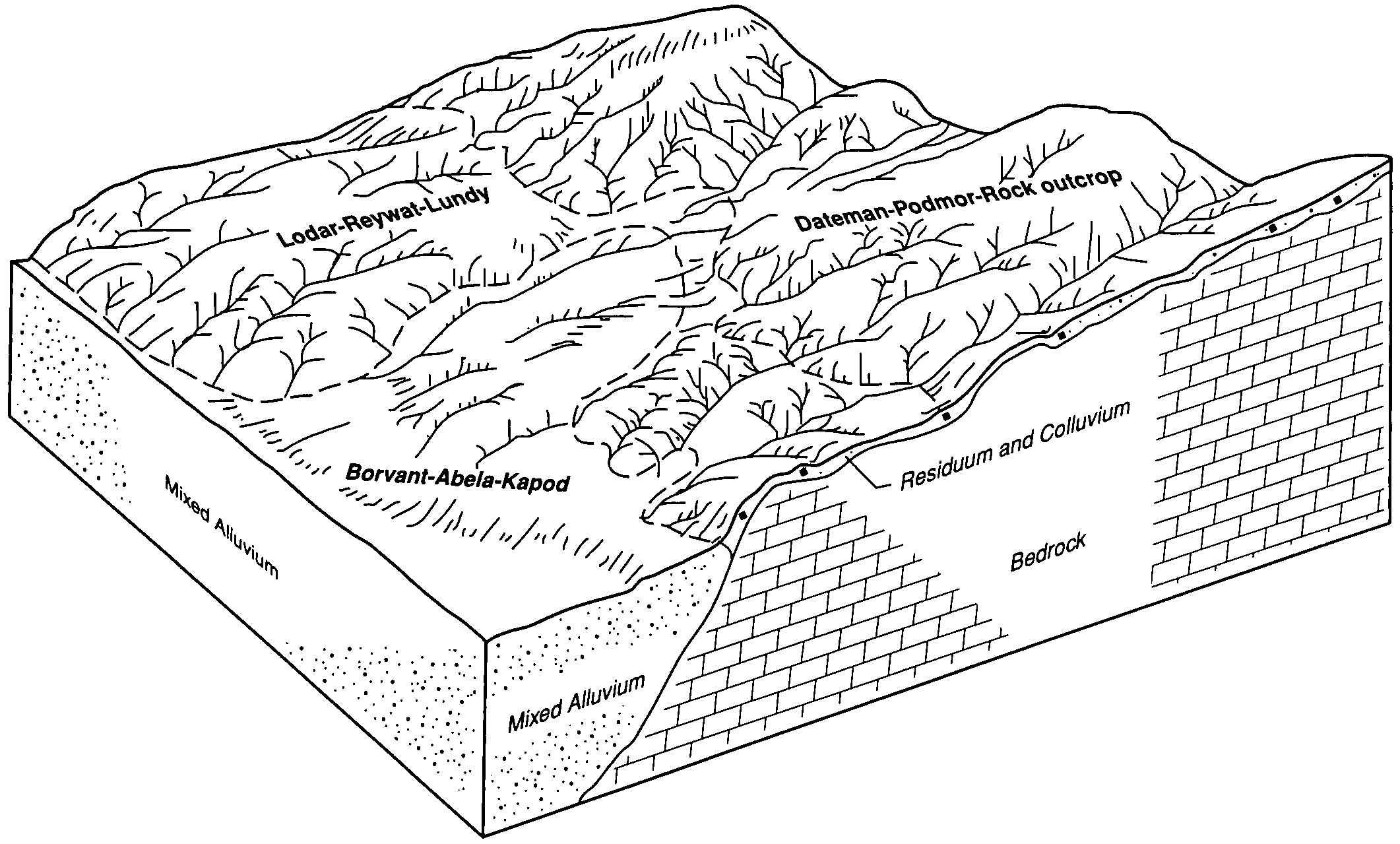
Reywat-Marepas association | 539 | 6704 | 1387143 | 1hkfk | ca685 | 2006 | 1:24000 |
Devada-Reywat-Rubble land association | 374 | 6243 | 1034696 | 13qp9 | ca685 | 2006 | 1:24000 |
Reywat-Devada association | 537 | 5508 | 1034657 | 13qn1 | ca685 | 2006 | 1:24000 |
Devada-Reywat-Rock outcrop association | 373 | 3605 | 1034695 | 13qp8 | ca685 | 2006 | 1:24000 |
Reywat-Rock outcrop-Marepas association | 540 | 3486 | 1387144 | 1hkfl | ca685 | 2006 | 1:24000 |
Bucklake-Reywat association | 328 | 3243 | 1034656 | 13qn0 | ca685 | 2006 | 1:24000 |
Old Camp-Reywat-Rubble land association | 500 | 2986 | 1034738 | 13qqn | ca685 | 2006 | 1:24000 |
Steerlake-Reywat association | 572 | 1998 | 1034677 | 13qnp | ca685 | 2006 | 1:24000 |
Bucklake-Bombadil-Reywat association | 325 | 1420 | 1034727 | 13qq9 | ca685 | 2006 | 1:24000 |
Reywat cobbly loam, 4 to 15 percent slopes | 535 | 762 | 1034713 | 13qpv | ca685 | 2006 | 1:24000 |
Reywat very stony loam, 8 to 30 percent slopes | 536 | 449 | 1034767 | 13qrl | ca685 | 2006 | 1:24000 |
Reywat-Fernpoint association | 538 | 139 | 1034768 | 13qrm | ca685 | 2006 | 1:24000 |
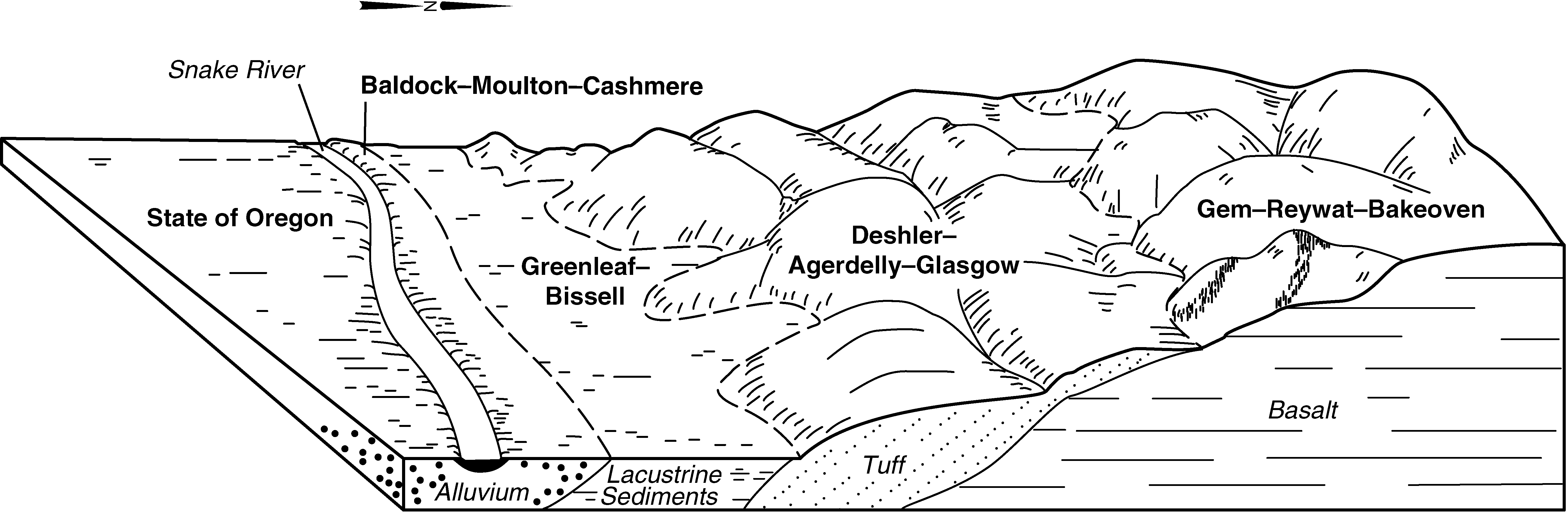
Gem-Reywat complex, 2 to 30 percent slopes | 73 | 61448 | 81270 | 2qkm | id656 | 1992 | 1:24000 |
Gem-Reywat complex, 30 to 65 percent slopes | 74 | 49983 | 81271 | 2qkn | id656 | 1992 | 1:24000 |
Bakeoven-Reywat complex, 2 to 30 percent slopes | 13 | 48312 | 81129 | 2qf2 | id656 | 1992 | 1:24000 |
Bakeoven-Reywat-Rock outcrop complex, 30 to 60 percent slopes | 14 | 41369 | 81140 | 2qff | id656 | 1992 | 1:24000 |
Cranecreek-Reywat complex, 2 to 25 percent slopes | 37 | 15576 | 81230 | 2qjb | id656 | 1992 | 1:24000 |
Reywat-Bakeoven complex, 30 to 60 percent slopes | RBF | 6376 | 81385 | 2qpb | id659 | 1971 | 1:20000 |
Reywat-Bakeoven complex, 2 to 30 percent slopes | RBE | 3333 | 81384 | 2qp9 | id659 | 1971 | 1:20000 |
Reywat gravelly loam, 0 to 30 percent slopes | 53-CW | 7139 | 3469140 | 2rqp | id700 | | 1:24000 |
Bakeoven-Reywat-Rock outcrop complex, 30 to 60 percent slopes | 656014 | 773 | 3332358 | 2qff | id700 | | 1:24000 |
Gem-Reywat complex, 30 to 65 percent slopes | 656074 | 16 | 3332389 | 2qkn | id700 | | 1:24000 |
Gem-Reywat complex, 2 to 30 percent slopes | 656073 | 6 | 3332403 | 2qkm | id700 | | 1:24000 |
Reywat gravelly loam, 0 to 30 percent slopes | 53 | 7794 | 82388 | 2rqp | id707 | 1976 | 1:24000 |
Reywat gravelly loam, 0 to 30 percent slopes | 53-CW | 158 | 3403099 | 2rqp | id708 | 1987 | 1:24000 |
Devada-Old Camp-Reywat association | 7165 | 3260 | 2619435 | 2rbrt | nv625 | 1981 | 1:24000 |
Reywat-Ister-Rock outcrop association | 7740 | 2281 | 2619434 | 2ttw5 | nv625 | 1981 | 1:24000 |
Ister-Reywat-Koontz association | 244 | 486 | 474112 | 2w4fc | nv625 | 1981 | 1:24000 |
Yuko-Reywat-Rock outcrop association | 342 | 6153 | 474271 | hxj2 | nv628 | 1980 | 1:24000 |
Tristan-Arzo-Reywat association | 1272 | 4292 | 474163 | hxdl | nv628 | 1980 | 1:24000 |
Reywat-Rock outcrop complex, 15 to 50 percent slopes | 863 | 3844 | 474392 | hxmz | nv628 | 1980 | 1:24000 |
Reywat extremely stony loam, 15 to 30 percent slopes | 861 | 1387 | 474390 | hxmx | nv628 | 1980 | 1:24000 |
Reywat-Ister-Rock outcrop association | 6740 | 1236 | 474451 | 2ttw5 | nv628 | 1980 | 1:24000 |
Reywat-Rock outcrop complex, cool, 15 to 50 percent slopes | 864 | 1176 | 474441 | hxpk | nv628 | 1980 | 1:24000 |
Reywat very cobbly sandy loam, 8 to 15 percent slopes | 862 | 655 | 474391 | hxmy | nv628 | 1980 | 1:24000 |
Ister-Reywat-Koontz association | 84 | 1630 | 2462793 | 2w4fc | nv629 | 1975 | 1:24000 |
Devada-Reywat association | 1167 | 18090 | 474504 | hxrl | nv759 | 1995 | 1:24000 |
Old Camp-Reywat-Rubble land association | 1065 | 8910 | 474474 | hxqm | nv759 | 1995 | 1:24000 |
Reywat-Fernpoint association | 1328 | 8260 | 474568 | hxtn | nv759 | 1995 | 1:24000 |
Reywat-Devada association | 1329 | 3530 | 474569 | hxtp | nv759 | 1995 | 1:24000 |
Reywat very stony loam, 8 to 30 percent slopes | 1326 | 3490 | 474566 | hxtl | nv759 | 1995 | 1:24000 |
Reywat-Westbutte-Hapgood association | 1327 | 3110 | 474567 | hxtm | nv759 | 1995 | 1:24000 |
Reywat-Devada-Hart Camp association | 1325 | 2590 | 474565 | hxtk | nv759 | 1995 | 1:24000 |
Hart Camp-Reywat-Westbutte association | 1276 | 310 | 474548 | hxt0 | nv759 | 1995 | 1:24000 |
Terca-Reywat-Wylo association | 374 | 40590 | 477477 | j0vh | nv771 | 1990 | 1:24000 |
Jaybee-Old Camp-Reywat association | 312 | 9721 | 477457 | j0tv | nv771 | 1990 | 1:24000 |
Bombadil-Old Camp-Reywat association | 280 | 9515 | 477450 | j0tm | nv771 | 1990 | 1:24000 |
Old Camp-Reywat-Jaybee association | 250 | 8990 | 477426 | j0sv | nv771 | 1990 | 1:24000 |
Old Camp-Reywat-Theon association | 258 | 7148 | 477433 | j0t2 | nv771 | 1990 | 1:24000 |
Bucklake-Reywat association | 513 | 5766 | 477499 | j0w6 | nv771 | 1990 | 1:24000 |
Bucklake-Bombadil-Reywat association | 510 | 5319 | 477496 | j0w3 | nv771 | 1990 | 1:24000 |
Reywat-Ister association | 344 | 4915 | 477470 | j0v8 | nv771 | 1990 | 1:24000 |
Bucklake-Reywat-Devada association | 515 | 4624 | 477500 | j0w7 | nv771 | 1990 | 1:24000 |
Devada-Reywat-Tunnison association | 138 | 4277 | 477356 | j0ql | nv771 | 1990 | 1:24000 |
Jaybee-Reywat association | 318 | 3974 | 477463 | j0v1 | nv771 | 1990 | 1:24000 |
Wylo-Reywat-Rock outcrop association | 279 | 2736 | 477449 | j0tl | nv771 | 1990 | 1:24000 |
Reywat-Rock outcrop complex, 15 to 50 percent slopes | 340 | 450 | 477466 | j0v4 | nv771 | 1990 | 1:24000 |
Reywat-Ister-Rock outcrop association | 740 | 11510 | 2619450 | 2ttw5 | nv772 | 1985 | 1:24000 |
Devada-Reywat-Duco association | 163 | 9450 | 2452702 | 2nb7f | nv772 | 1985 | 1:24000 |
Reywat-Devada-Rock outcrop association | 741 | 4750 | 2452733 | 2nb8f | nv772 | 1985 | 1:24000 |
Reywat-Tristan-Devada association | 743 | 3640 | 2452735 | 2nb8h | nv772 | 1985 | 1:24000 |
Reywat-Devada-Ister association | 742 | 2560 | 2452734 | 2nb8g | nv772 | 1985 | 1:24000 |
Devada-Old Camp-Reywat association | 165 | 100 | 2452704 | 2nb7h | nv772 | 1985 | 1:24000 |
Old Camp-Reywat association | 6994 | 95 | 644589 | pmr6 | nv773 | 1981 | 1:24000 |
Devada-Reywat association | 1167 | 4390 | 3423064 | hxrl | nv792 | 2025 | 1:24000 |
Hart Camp-Reywat-Westbutte association | 1276 | 87 | 3423074 | hxt0 | nv792 | 2025 | 1:24000 |
Reywat-Barbermill-Rock outcrop complex, 10 to 40 percent slopes | 109E | 73 | 3425187 | t6sf | or627 | | 1:24000 |
Reywat very stony loam, 2 to 15 percent slopes | 119C | 48 | 3425125 | nfpl | or627 | | 1:24000 |
Cant-Drinkwater-Reywat complex, 5 to 30 percent south slopes | 120D | 39 | 3425028 | nfpm | or627 | | 1:24000 |
Cant-Reywat complex, 2 to 15 percent slopes | 120C | 7 | 3426038 | 2dv1n | or627 | | 1:24000 |
Ruclick-Reywat-Rock outcrop complex, 20 to 50 percent south slopes | 5021 | 4306 | 2722282 | 2sf3j | or645 | | 1:24000 |
Reywat-Rock outcrop complex, 60 to 90 percent north slopes | 355F | 12 | 3472545 | 269h | or666 | 1970 | 1:31680 |
Cant-Drinkwater-Reywat complex, 5 to 30 percent south slopes | 120D | 3329 | 3421788 | nfpm | or677 | | 1:24000 |
Reywat-Rock outcrop-Searles complex, 15 to 75 percent slopes | BLW2 | 2176 | 3421844 | 2krls | or677 | | 1:24000 |
Cant-Reywat complex, 2 to 15 percent slopes | 120C | 1060 | 3424998 | 2dv1n | or677 | | 1:24000 |
Reywat-Rock outcrop complex, 60 to 90 percent north slopes | 355F | 1005 | 3421955 | 269h | or677 | | 1:24000 |
Twickenham-Reywat-Rock outcrop complex, 15 to 75 percent slopes | BLW1 | 976 | 3421976 | 2krlr | or677 | | 1:24000 |
Reywat very stony loam, 2 to 15 percent slopes | 119C | 340 | 3424612 | nfpl | or677 | | 1:24000 |
Reywat-Barbermill-Rock outcrop complex, 10 to 40 percent slopes | 109E | 35 | 3424862 | t6sf | or677 | | 1:24000 |
Sumine-Reywat-Rock outcrop complex, 10 to 30 percent slopes | SsE | 25231 | 482626 | j66l | ut608 | 1981 | 1:24000 |
Reywat-Rock outcrop complex, 30 to 60 percent slopes | ReF | 12102 | 482594 | j65k | ut608 | 1981 | 1:24000 |
Sumine-Reywat-Rock outcrop complex, 30 to 60 percent slopes | SsF | 11705 | 482627 | j66m | ut608 | 1981 | 1:24000 |
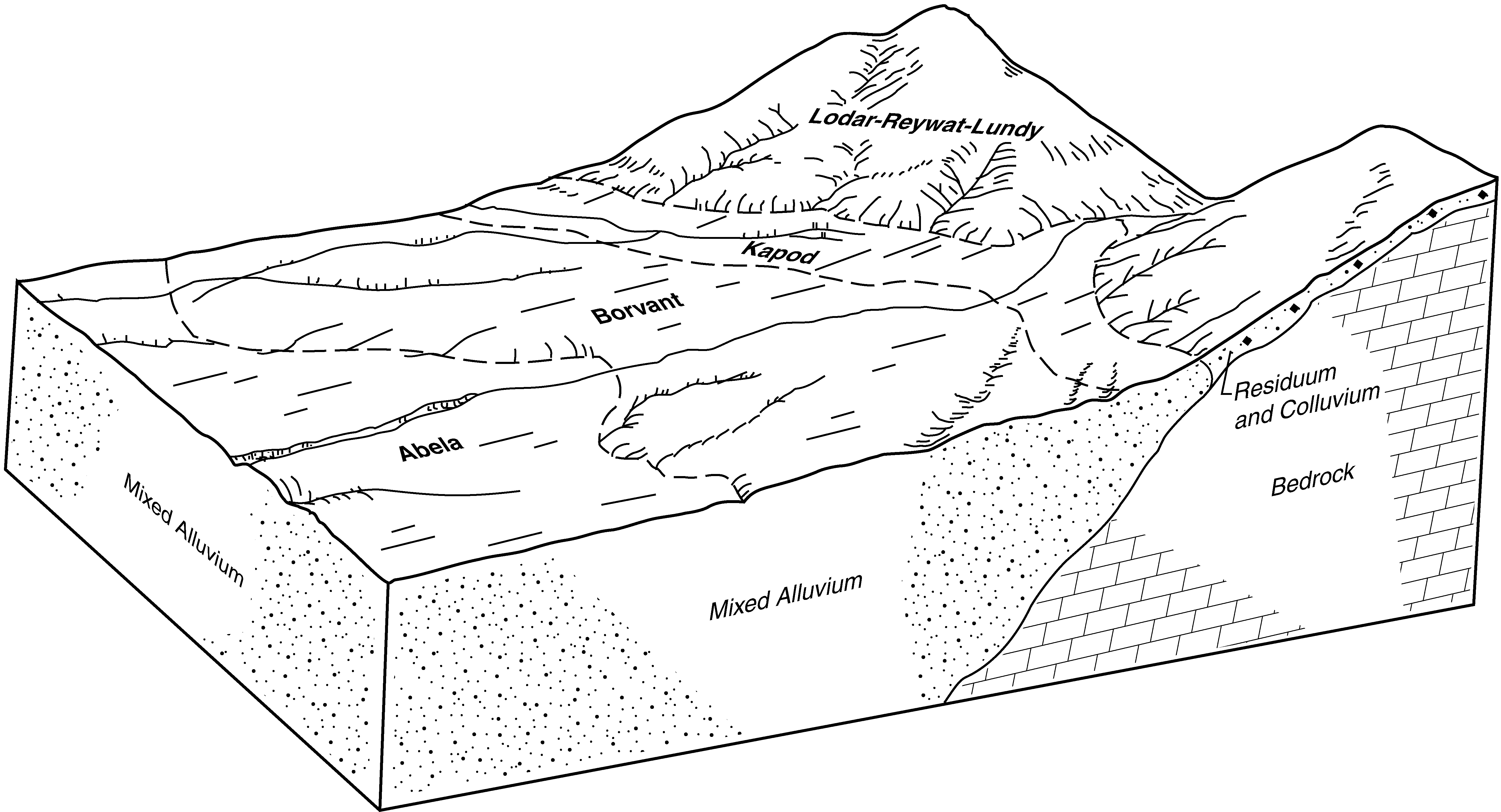
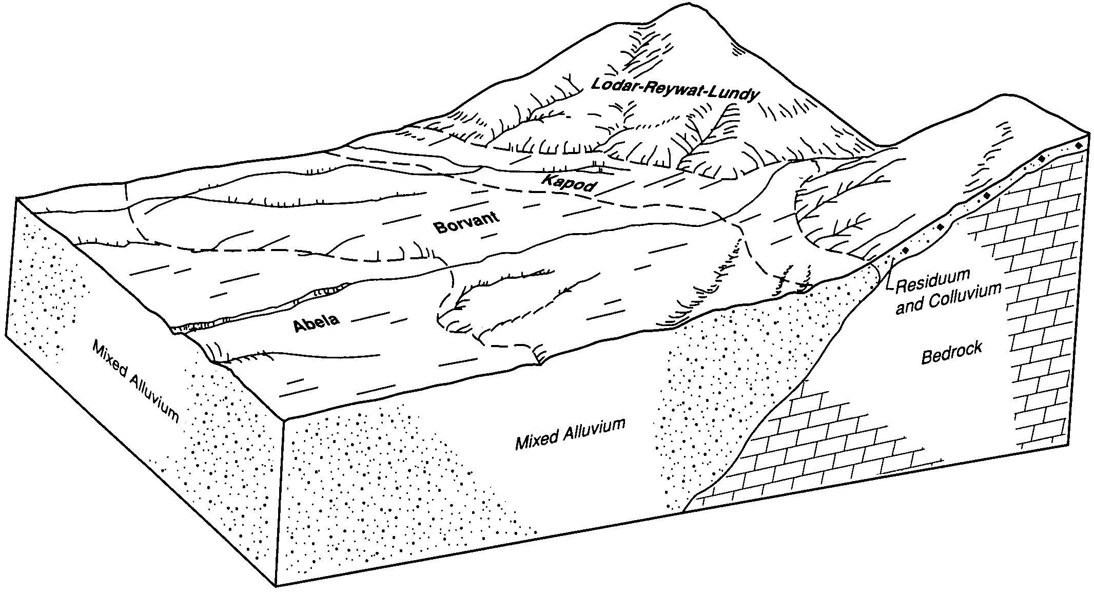
Borvant-Reywat complex, 8 to 30 percent slopes | BhD | 6764 | 482466 | j61f | ut608 | 1981 | 1:24000 |
Reywat-Rock outcrop complex, 10 to 30 percent slopes | ReE | 5613 | 482593 | j65j | ut608 | 1981 | 1:24000 |
Borvant-Reywat complex, 30 to 60 percent slopes | BhF | 5129 | 482467 | j61g | ut608 | 1981 | 1:24000 |
Reywat-Reebok-Rock outcrop complex, 10 to 30 percent slopes | RdE | 3149 | 482592 | j65h | ut608 | 1981 | 1:24000 |
Reywat-Broad-Rock outcrop association, 30 to 60 percent slopes | 48 | 94349 | 482155 | j5qd | ut611 | 1992 | 1:24000 |
Broad, moist-Reywat, moist-Rock outcrop association, 30 to 60 percent slopes | 10 | 16076 | 482112 | j5p0 | ut611 | 1992 | 1:24000 |
Reywat-Broad families-Rock outcrop association, 15 to 80 percent slopes | 64 | 26200 | 3183891 | 2x4gn | ut617 | | 1:24000 |
Reywat-Red Butte families complex, 5 to 50 percent slopes | 62 | 9493 | 3183889 | 2x4gl | ut617 | | 1:24000 |
Reywat family-Rock outcrop complex, 15 to 80 percent slopes | 63 | 4401 | 3183890 | 2x4gm | ut617 | | 1:24000 |
Red Butte-Kanarra-Reywat families, association, 5 to 40 percent slopes | 188 | | 625244 | nzm5 | ut649 | | 1:24000 |
Reywat-Pharo-Amtoft families, complex, 25 to 65 percent slopes | 190 | | 581656 | mj83 | ut649 | | 1:24000 |

