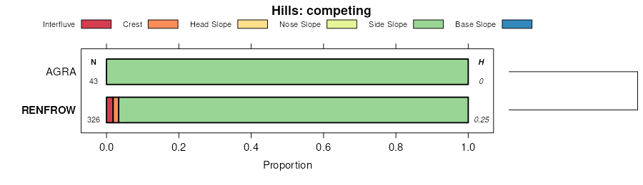
| Kirkland-Renfrow clay loams, 1 to 3 percent slopes | 6360 | 17982 | 1382702 | 30x0w | ks077 | 1965 | 1:24000 |
Kirkland-Renfrow soils, 1 to 3 percent slopes, eroded | 6362 | 3532 | 1382703 | 1hdtb | ks077 | 1965 | 1:24000 |
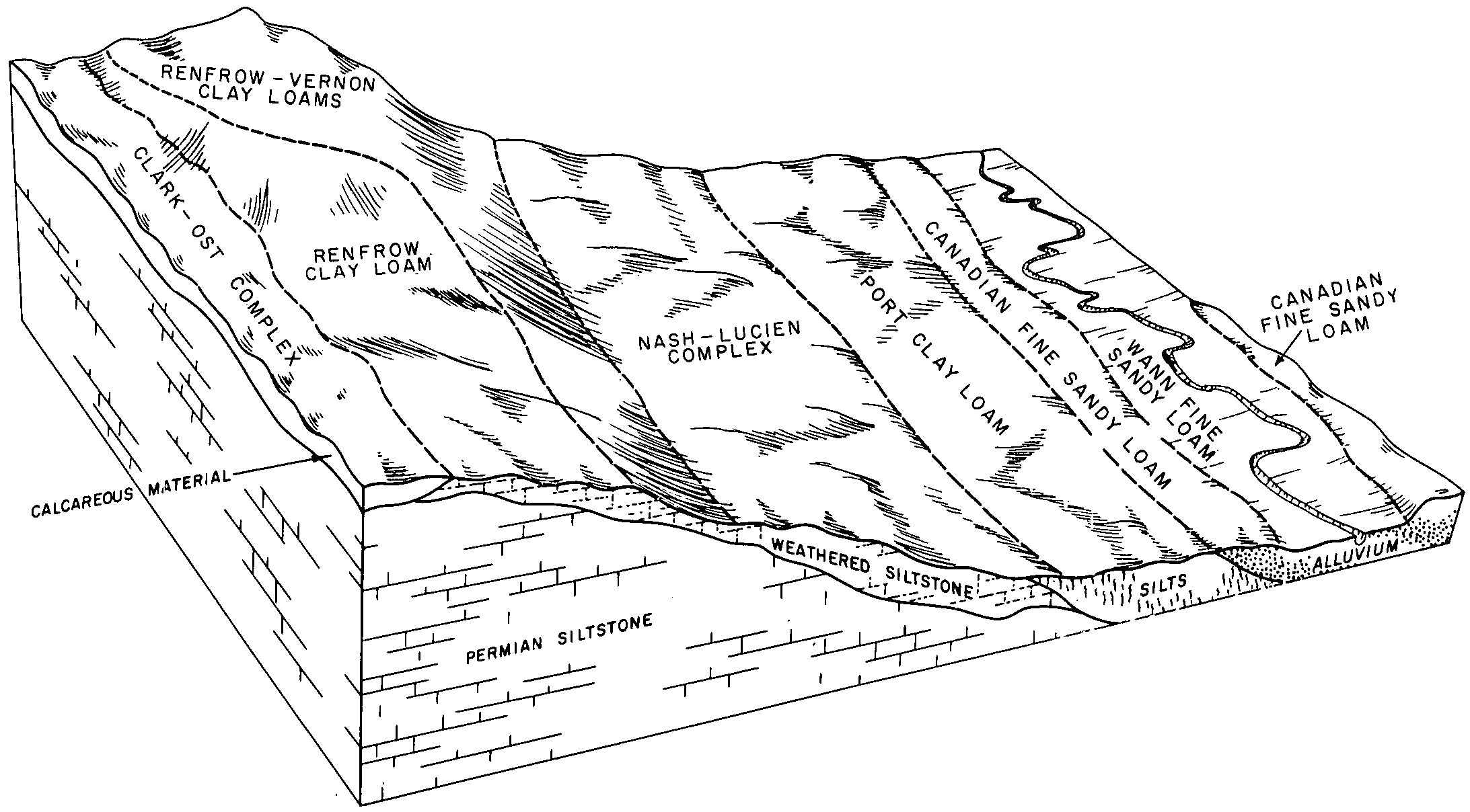
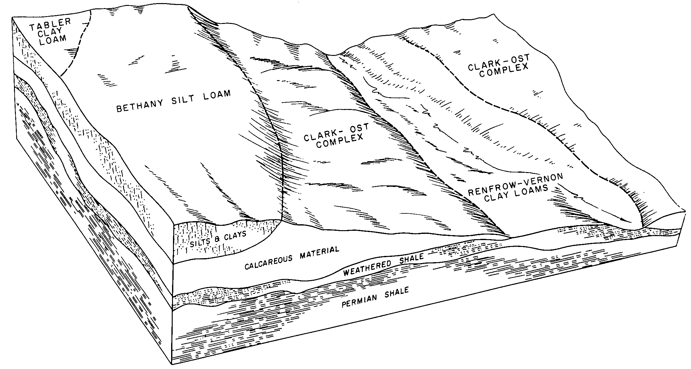
Renfrow-Vernon clay loams, 1 to 3 percent slopes | 6422 | 1637 | 1382730 | 31c48 | ks077 | 1965 | 1:24000 |
Vernon-Renfrow complex, 3 to 7 percent slopes, eroded | 6445 | 559 | 1382748 | 1hdvs | ks077 | 1965 | 1:24000 |
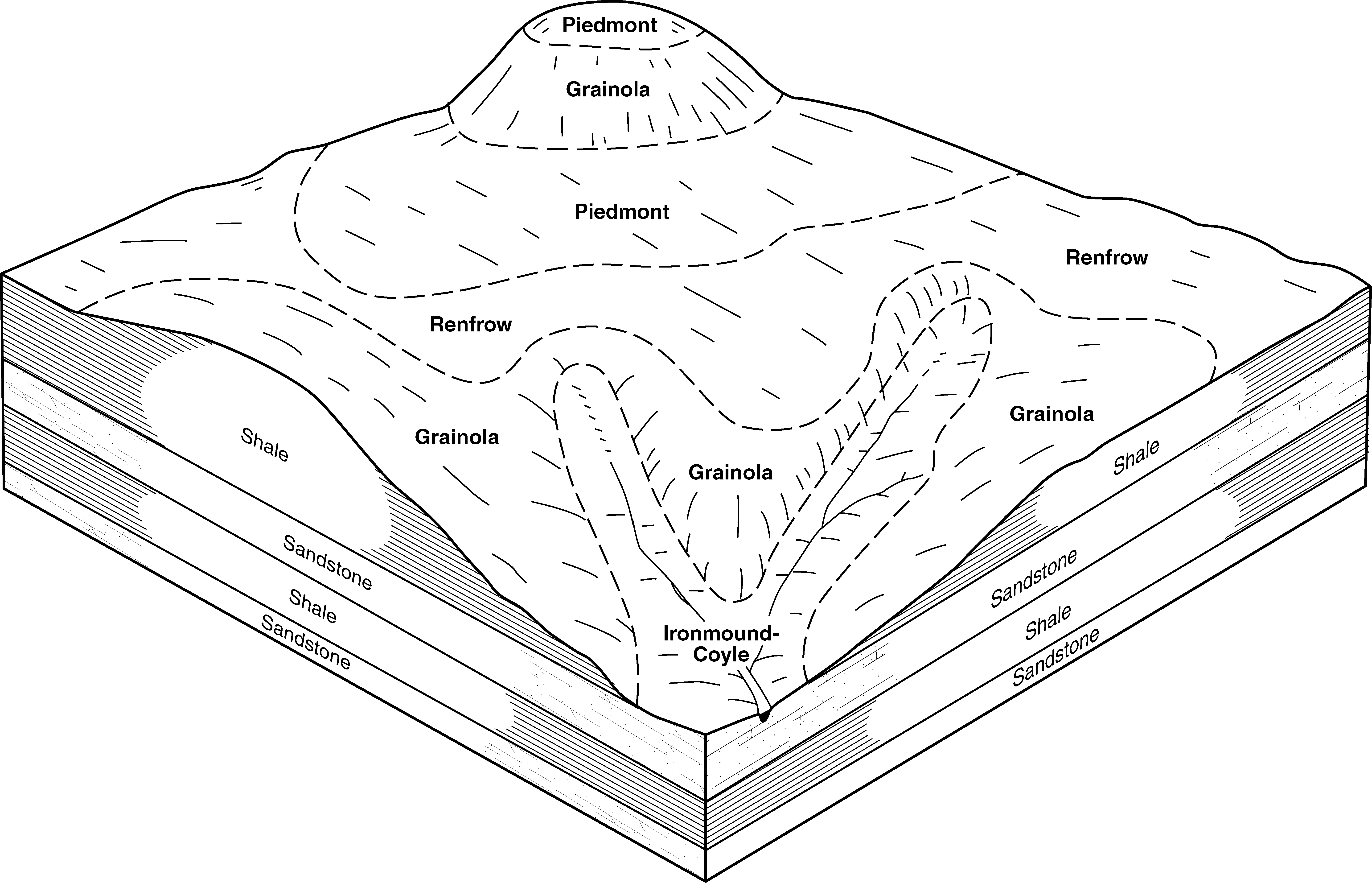
Renfrow-Grainola complex, 1 to 3 percent slopes | 6421 | 12 | 1382729 | 1hdv5 | ks077 | 1965 | 1:24000 |
Renfrow clay loam, 1 to 3 percent slopes | 6418 | 16798 | 1444835 | 2wtxm | ks095 | 1977 | 1:24000 |
Renfrow silty clay loam, 1 to 3 percent slopes | 6419 | 1857 | 1444836 | 2wtxn | ks095 | 1977 | 1:24000 |
Kirkland-Renfrow clay loams, 1 to 3 percent slopes | 6360 | 219 | 1444828 | 30x0w | ks095 | 1977 | 1:24000 |
Renfrow-Vernon clay loams, 1 to 3 percent slopes | 6422 | 82 | 1444838 | 31c48 | ks095 | 1977 | 1:24000 |
Renfrow-Grainola complex, 1 to 3 percent slopes | 6421 | 23 | 1444837 | 1khgn | ks095 | 1977 | 1:24000 |
Renfrow-Wellsford clay loams, 1 to 4 percent slopes | 6423 | 3 | 1444839 | 2ywsw | ks095 | 1977 | 1:24000 |
Renfrow silty clay loam, 1 to 3 percent slopes | 6419 | 14768 | 1444020 | 2wtxn | ks173 | 1976 | 1:24000 |
Renfrow silty clay loam, 3 to 6 percent slopes | 6420 | 1672 | 1444021 | 2ywsv | ks173 | 1976 | 1:24000 |
Renfrow-Wellsford clay loams, 1 to 4 percent slopes | 6423 | 1523 | 1444022 | 2ywsw | ks173 | 1976 | 1:24000 |
Renfrow-Grainola complex, 1 to 3 percent slopes | 6421 | 26213 | 1444666 | 1kh94 | ks191 | 1974 | 1:24000 |
Wellsford-Renfrow clay loams, 2 to 6 percent slopes, eroded | 5465 | 1331 | 1444607 | 1kh77 | ks191 | 1974 | 1:24000 |
Kirkland-Renfrow clay loams, 1 to 3 percent slopes | 6360 | 523 | 1444654 | 30x0w | ks191 | 1974 | 1:24000 |
Kirkland-Renfrow soils, 1 to 3 percent slopes, eroded | 6362 | 47 | 1444655 | 1kh8s | ks191 | 1974 | 1:24000 |
Renfrow silty clay loam, 1 to 3 percent slopes | 6419 | 33 | 1444665 | 2wtxn | ks191 | 1974 | 1:24000 |
Renfrow clay loam, 1 to 3 percent slopes | 6418 | 8 | 1444664 | 2wtxm | ks191 | 1974 | 1:24000 |
Renfrow silt loam, 0 to 2 percent slopes | RcA | 4585 | 381442 | dsxl | ok003 | 1971 | 1:24000 |
Renfrow clay loam, 3 to 5 percent slopes, eroded | RcC2 | 17239 | 381978 | dtgw | ok017 | 1972 | 1:24000 |
Renfrow silt loam, 1 to 3 percent slopes | RbB | 9175 | 381977 | 2rj9l | ok017 | 1972 | 1:24000 |
Renfrow silt loam, 0 to 1 percent slopes | RbA | 2359 | 381976 | dtgt | ok017 | 1972 | 1:24000 |
Renfrow silt loam, 1 to 3 percent slopes | 37 | 8118 | 382021 | 2rj9l | ok019 | 1977 | 1:24000 |
Renfrow silt loam, 3 to 5 percent slopes | 38 | 2632 | 382022 | 2tp5h | ok019 | 1977 | 1:24000 |
Renfrow-Huska complex, 3 to 5 percent slopes, eroded | 65 | 10981 | 382128 | dtmq | ok027 | 1984 | 1:24000 |
Renfrow-Huska complex, 3 to 5 percent slopes | 66 | 4841 | 382129 | dtmr | ok027 | 1984 | 1:24000 |
Renfrow silty clay loam, 3 to 5 percent slopes, eroded | 64 | 4144 | 382127 | 2tp5w | ok027 | 1984 | 1:24000 |
Renfrow-Urban land-Huska complex, 1 to 5 percent slopes | 69 | 2007 | 382132 | dtmv | ok027 | 1984 | 1:24000 |
Renfrow silt loam, 1 to 3 percent slopes | 62 | 2002 | 382125 | 2rj9l | ok027 | 1984 | 1:24000 |
Renfrow silt loam, 3 to 5 percent slopes | 63 | 1323 | 382126 | 2tp5h | ok027 | 1984 | 1:24000 |
Renfrow silt loam, 1 to 3 percent slopes | RenB | 73 | 2516367 | 2rj9l | ok037 | 1952 | 1:24000 |
Kirkland-Renfrow complex, 1 to 3 percent slopes | KrB | 96816 | 382501 | 2tp5r | ok047 | 1965 | 1:24000 |
Renfrow silt loam, 3 to 5 percent slopes, eroded | 63 | 29761 | 382598 | 2tp5j | ok049 | 1982 | 1:24000 |
Renfrow silt loam, 3 to 5 percent slopes, gullied | 64 | 12006 | 382599 | dv3x | ok049 | 1982 | 1:24000 |
Renfrow silt loam, 1 to 3 percent slopes | 61 | 8104 | 382596 | 2rj9l | ok049 | 1982 | 1:24000 |
Renfrow silt loam, 3 to 5 percent slopes | 62 | 3913 | 382597 | 2tp5h | ok049 | 1982 | 1:24000 |
Renfrow-Urban land complex, 1 to 5 percent slopes | 65 | 267 | 382600 | 2tp5k | ok049 | 1982 | 1:24000 |
Renfrow silt loam, 3 to 5 percent slopes, eroded | 45 | 15030 | 382666 | 2tp5j | ok051 | 1975 | 1:24000 |
Renfrow silt loam, 1 to 3 percent slopes | 44 | 12078 | 382665 | 2rj9l | ok051 | 1975 | 1:24000 |
Renfrow silt loam, 3 to 5 percent slopes, severely eroded | 46 | 5584 | 382667 | 2tp5l | ok051 | 1975 | 1:24000 |
Renfrow-Huska complex, 1 to 3 percent slopes | 47 | 1974 | 382668 | dv64 | ok051 | 1975 | 1:24000 |
Renfrow silty clay loam, 3 to 5 percent slopes, eroded | 49 | 17617 | 382739 | 2tp5w | ok053 | 1983 | 1:24000 |
Renfrow silt loam, 3 to 5 percent slopes | 48 | 8938 | 382738 | 2tp5h | ok053 | 1983 | 1:24000 |
Renfrow-Pawhuska complex, 3 to 5 percent slopes, eroded | 50 | 3817 | 382741 | dv8h | ok053 | 1983 | 1:24000 |
Renfrow silt loam, 1 to 3 percent slopes | RenB | 731 | 601436 | 2rj9l | ok053 | 1983 | 1:24000 |
Renfrow silt loam, 3 to 5 percent slopes, eroded | ReC2 | 1207 | 383240 | 2tp5j | ok067 | 1967 | 1:24000 |
Renfrow silt loam, 3 to 5 percent slopes, severely eroded | RfC3 | 1187 | 383241 | 2tp5l | ok067 | 1967 | 1:24000 |
Kirkland-Renfrow complex, 3 to 5 percent slopes, eroded | KrC2 | 41437 | 383334 | dvwm | ok071 | 1965 | 1:24000 |
Renfrow-Kirkland complex, 3 to 5 percent slopes | RkC | 5823 | 383363 | dvxk | ok071 | 1965 | 1:24000 |
Renfrow, Grainola, and Pawhuska soils, 3 to 8 percent slopes, severely eroded | Es | 1726 | 383328 | 2tp5m | ok071 | 1965 | 1:24000 |
Renfrow silt loam, 1 to 3 percent slopes | RenB | 29 | 623484 | 2rj9l | ok071 | 1965 | 1:24000 |
Renfrow clay loam, 0 to 1 percent slopes | RcA | 8158 | 383412 | dvz4 | ok073 | 1960 | 1:24000 |
Renfrow silty clay loam, 3 to 5 percent slopes, eroded | RewC2 | 13938 | 383669 | 2tp5w | ok083 | 1994 | 1:12000 |
Renfrow silt loam, 1 to 3 percent slopes | RenB | 8202 | 383667 | 2rj9l | ok083 | 1994 | 1:12000 |
Renfrow silt loam, 3 to 5 percent slopes | RenC | 555 | 383668 | 2tp5h | ok083 | 1994 | 1:12000 |
Renfrow silt loam, 1 to 3 percent slopes | ReB | 876 | 383735 | 2rj9l | ok085 | 1963 | 1:24000 |
Renfrow silt loam, 3 to 5 percent slopes, eroded | 41 | 11550 | 383799 | 2tp5j | ok087 | 1976 | 1:24000 |
Renfrow silt loam, 3 to 5 percent slopes | 40 | 3410 | 383798 | 2tp5h | ok087 | 1976 | 1:24000 |
Renfrow silt loam, 3 to 5 percent slopes, severely eroded | 42 | 1374 | 383800 | 2tp5l | ok087 | 1976 | 1:24000 |
Renfrow silt loam, 1 to 3 percent slopes | RenB | 570 | 1726417 | 2rj9l | ok087 | 1976 | 1:24000 |
Renfrow silty clay loam, 1 to 3 percent slopes | RcB | 6776 | 383856 | dwfg | ok093 | 1965 | 1:24000 |
Renfrow silty clay loam, 0 to 1 percent slopes | RcA | 981 | 383855 | dwff | ok093 | 1965 | 1:24000 |
Renfrow silt loam, 1 to 3 percent slopes | 48 | 524 | 383955 | 2rj9l | ok099 | 1982 | 1:24000 |
Renfrow and Grainola soils, 3 to 5 percent slopes, eroded | ReGC2 | 24745 | 384106 | 2tp5s | ok103 | 1994 | 1:24000 |
Renfrow silt loam, 1 to 3 percent slopes | RenB | 14129 | 384109 | 2rj9l | ok103 | 1994 | 1:24000 |
Renfrow silt loam, 3 to 5 percent slopes | RenC | 9609 | 384110 | 2tp5h | ok103 | 1994 | 1:24000 |
Renfrow, Grainola, and Pawhuska soils, 3 to 8 percent slopes, severely eroded | RGPD3 | 4511 | 384105 | 2tp5m | ok103 | 1994 | 1:24000 |
Renfrow loam, 3 to 5 percent slopes, eroded | RefC2 | 44 | 384107 | 2tp5v | ok103 | 1994 | 1:24000 |
Renfrow silty clay loam, 3 to 5 percent slopes, eroded | RewC2 | 33 | 384111 | 2tp5w | ok103 | 1994 | 1:24000 |
Renfrow silt loam, 3 to 5 percent slopes | RenC | 1325 | 384200 | 2tp5h | ok107 | 1996 | 1:24000 |
Renfrow silt loam, 1 to 3 percent slopes | RenB | 5854 | 384348 | 2rj9l | ok109 | 1996 | 1:12000 |
Renfrow silt loam, 3 to 5 percent slopes, eroded | RenC2 | 10297 | 1423185 | 2tp5j | ok117 | 2007 | 1:24000 |
Renfrow silt loam, 1 to 3 percent slopes | RenB | 9263 | 1423183 | 2rj9l | ok117 | 2007 | 1:24000 |
Renfrow silt loam, 3 to 5 percent slopes | RenC | 8717 | 1412994 | 2tp5h | ok117 | 2007 | 1:24000 |
Renfrow, Grainola, and Pawhuska soils, 3 to 8 percent slopes, severely eroded | RGPD3 | 2519 | 1677033 | 2tp5m | ok117 | 2007 | 1:24000 |
Renfrow loam, 3 to 5 percent slopes, eroded | RefC2 | 19 | 1901761 | 2tp5v | ok117 | 2007 | 1:24000 |
Renfrow loam, 3 to 5 percent slopes, eroded | 47 | 14038 | 384545 | 2tp5v | ok119 | 1983 | 1:24000 |
Renfrow and Grainola soils, 3 to 8 percent slopes, severely eroded | 49 | 9496 | 384547 | dx4r | ok119 | 1983 | 1:24000 |
Renfrow silt loam, 3 to 5 percent slopes | 46 | 5022 | 384544 | 2tp5h | ok119 | 1983 | 1:24000 |
Renfrow silt loam, 1 to 3 percent slopes | 45 | 4151 | 384543 | 2rj9l | ok119 | 1983 | 1:24000 |
Renfrow-Urban land complex, 1 to 5 percent slopes | 80 | 3153 | 384582 | 2tp5k | ok119 | 1983 | 1:24000 |
Renfrow silt loam, 1 to 3 percent slopes | 36 | 7798 | 384697 | 2rj9l | ok125 | 1975 | 1:24000 |
Renfrow silt loam, 3 to 5 percent slopes | 37 | 5912 | 384698 | 2tp5h | ok125 | 1975 | 1:24000 |
Kirkland-Renfrow complex, 1 to 3 percent slopes | KrB | 23794 | 384866 | 2tp5r | ok137 | 1960 | 1:24000 |
Renfrow and Pawhuska soils, 1 to 5 percent slopes, severely eroded | Es | 5247 | 384860 | dxgv | ok137 | 1960 | 1:24000 |
Renfrow and Kirkland soils, 1 to 5 percent slopes, eroded | RfB2 | 4764 | 384880 | dxhh | ok137 | 1960 | 1:24000 |
Renfrow silt loam, 3 to 5 percent slopes | ReC | 3116 | 384879 | 2tp5h | ok137 | 1960 | 1:24000 |
Renfrow-Kirkland-Anocon association, nearly level | 45 | 85489 | 363899 | d6np | tx077 | 1977 | 1:24000 |
Renfrow-Waurika complex, 0 to 2 percent slopes | 46 | 40059 | 363900 | d6nq | tx077 | 1977 | 1:24000 |
Renfrow loam, 1 to 4 percent slopes | 28 | 36106 | 370773 | dftf | tx337 | 1975 | 1:24000 |
Waurika-Renfrow complex, 0 to 1 percent slopes | 41 | 14511 | 370788 | dftx | tx337 | 1975 | 1:24000 |
Renfrow loam, 1 to 3 percent slopes | ReB | 4257 | 373382 | djjl | tx485 | 1972 | 1:20000 |
Renfrow loam, 0 to 1 percent slopes | ReA | 579 | 373381 | djjk | tx485 | 1972 | 1:20000 |
Renfrow-Urban land complex, 1 to 5 percent slopes | RfB | 531 | 373383 | 2tp5k | tx485 | 1972 | 1:20000 |