| Ree silt loam, 3 to 6 percent slopes | 3301 | 13559 | 357658 | 2xfy4 | ne015 | 1976 | 1:20000 |
Ree silt loam, 6 to 11 percent slopes | 3302 | 5417 | 357659 | 2ym7s | ne015 | 1976 | 1:20000 |
Ree silt loam, 11 to 20 percent slopes | 3300 | 1321 | 357660 | 2ym7t | ne015 | 1976 | 1:20000 |
Ree loam, 0 to 3 percent slopes | 3298 | 1279 | 357727 | 2xfy2 | ne103 | 1977 | 1:20000 |
Ree loam, clayey substratum, 0 to 2 percent slopes | 3299 | 512 | 357728 | d07m | ne103 | 1977 | 1:20000 |
Ree loam, 3 to 6 percent slopes | RaB | 16918 | 355281 | 2xfy3 | sd053 | 1982 | 1:20000 |
Ree loam, gravelly substratum, 0 to 2 percent slopes | RbA | 8094 | 355283 | cxpr | sd053 | 1982 | 1:20000 |
Ree loam, 6 to 9 percent slopes | RaC | 6079 | 355282 | 2wfqq | sd053 | 1982 | 1:20000 |
Ree loam, 0 to 3 percent slopes | RaA | 3158 | 355280 | 2xfy2 | sd053 | 1982 | 1:20000 |
Ree-Tassel complex, 3 to 9 percent slopes | RcC | 1437 | 355284 | cxps | sd053 | 1982 | 1:20000 |
Ree loam, 0 to 3 percent slopes | ReA | 43023 | 354148 | 2xfy2 | sd055 | 1992 | 1:24000 |
Ree loam, 3 to 6 percent slopes | ReB | 6540 | 354149 | 2xfy3 | sd055 | 1992 | 1:24000 |
Ree-Canning loams, 2 to 6 percent slopes | RfB | 4717 | 354150 | cwj6 | sd055 | 1992 | 1:24000 |
Ree-Vivian complex, 6 to 15 percent slopes | RkD | 3795 | 354153 | cwj9 | sd055 | 1992 | 1:24000 |
Ree-Canning loams, 6 to 9 percent slopes | RfC | 1520 | 354151 | cwj7 | sd055 | 1992 | 1:24000 |
Ree-Hoven complex | Rh | 740 | 354152 | cwj8 | sd055 | 1992 | 1:24000 |
Ree loam, 0 to 2 percent slopes | ReA | 5838 | 353325 | cvnl | sd065 | 1970 | 1:20000 |
Ree loam, 2 to 5 percent slopes | ReB | 2643 | 353326 | cvnm | sd065 | 1970 | 1:20000 |
Ree-Mosher complex, 0 to 2 percent slopes | RmA | 1587 | 353327 | cvnn | sd065 | 1970 | 1:20000 |
Ree loam, 0 to 2 percent slopes | ReA | 124 | 353845 | cw6c | sd069 | 1992 | 1:20000 |
Ree-Canning loams, 0 to 2 percent slopes | RnA | 3737 | 356459 | cyxp | sd073 | 1987 | 1:20000 |
Ree loam, 0 to 2 percent slopes | ReA | 953 | 356457 | cyxm | sd073 | 1987 | 1:20000 |
Ree loam, 2 to 6 percent slopes | ReB | 859 | 356458 | cyxn | sd073 | 1987 | 1:20000 |
Ree-Canning loams, 2 to 6 percent slopes | RnB | 315 | 356460 | cyxq | sd073 | 1987 | 1:20000 |
Ree loam, 3 to 6 percent slopes | ReB | 2350 | 353675 | 2xfy3 | sd075 | 1991 | 1:24000 |
Ree loam, 6 to 9 percent slopes | ReC | 1050 | 353676 | 2wfqq | sd075 | 1991 | 1:24000 |
Ree loam, 0 to 3 percent slopes | ReA | 783 | 353674 | 2xfy2 | sd075 | 1991 | 1:24000 |
Ree silt loam, 3 to 6 percent slopes | ReB | 1703 | 355612 | 2xfy4 | sd085 | 1984 | 1:20000 |
Ree silt loam, 6 to 11 percent slopes | ReC | 803 | 355613 | 2ym7s | sd085 | 1984 | 1:20000 |
Ree and Keya loams, 0 to 2 percent slopes | RkA | 14744 | 353432 | cvs1 | sd095 | 1971 | 1:20000 |
Ree and Keya loams, 2 to 5 percent slopes | RkB | 11157 | 353433 | cvs2 | sd095 | 1971 | 1:20000 |
Ree loam, 3 to 6 percent slopes | ReB | 532 | 353431 | 2xfy3 | sd095 | 1971 | 1:20000 |
Ree loam, 0 to 2 percent slopes | ReA | 1916 | 355370 | cxsk | sd107 | 1983 | 1:20000 |
Ree loam, 0 to 3 percent slopes | ReA | 6720 | 353507 | 2xfy2 | sd117 | 1977 | 1:24000 |
Ree loam, 3 to 6 percent slopes | ReB | 719 | 353508 | 2xfy3 | sd117 | 1977 | 1:24000 |
Ree loam, 6 to 9 percent slopes | ReC | 322 | 353509 | 2wfqq | sd117 | 1977 | 1:24000 |
Ree loam, 0 to 2 percent slopes | ReA | 4736 | 353124 | cvg3 | sd119 | 1967 | 1:20000 |
Ree loam, 2 to 5 percent slopes | ReB | 2282 | 353125 | cvg4 | sd119 | 1967 | 1:20000 |
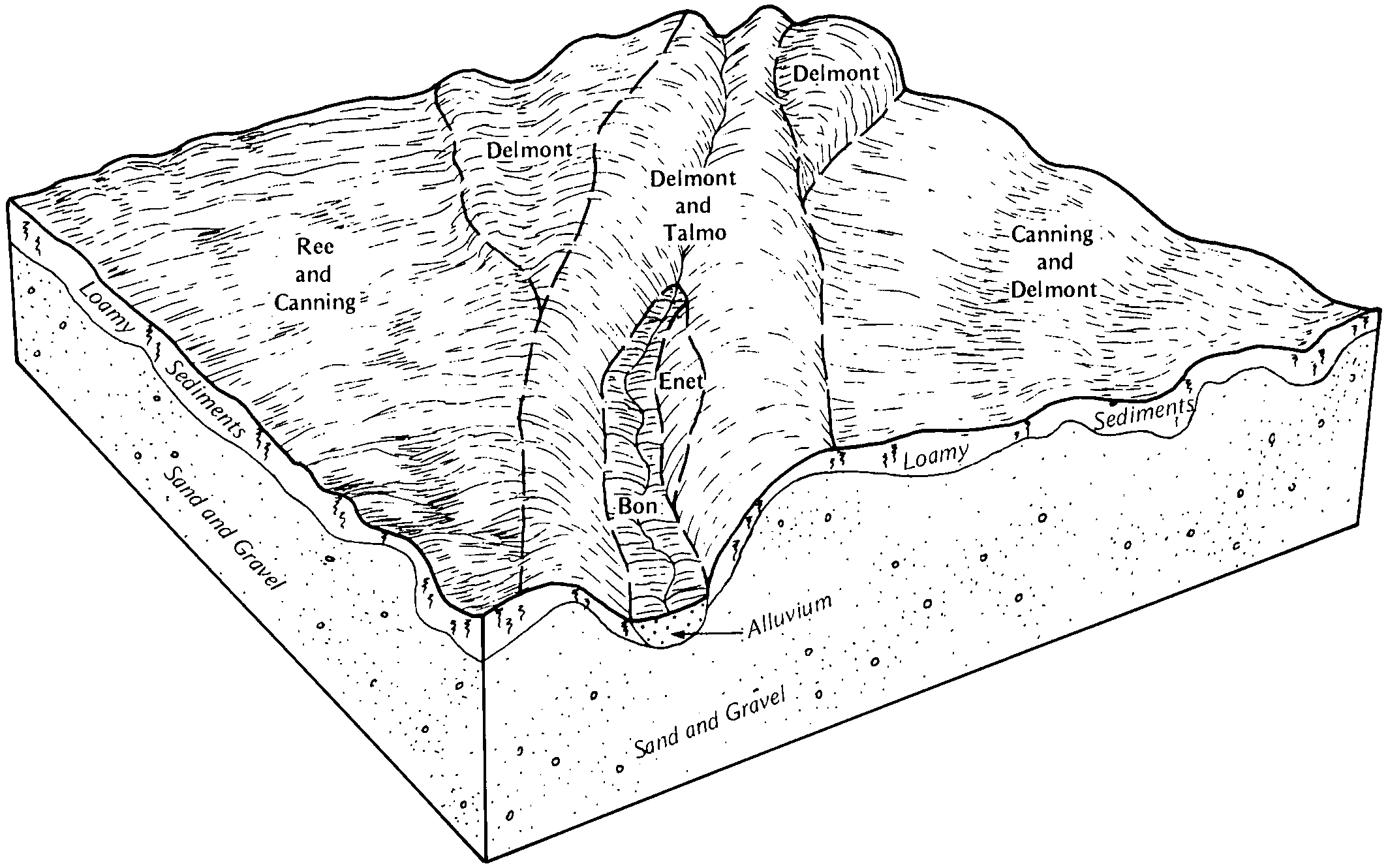
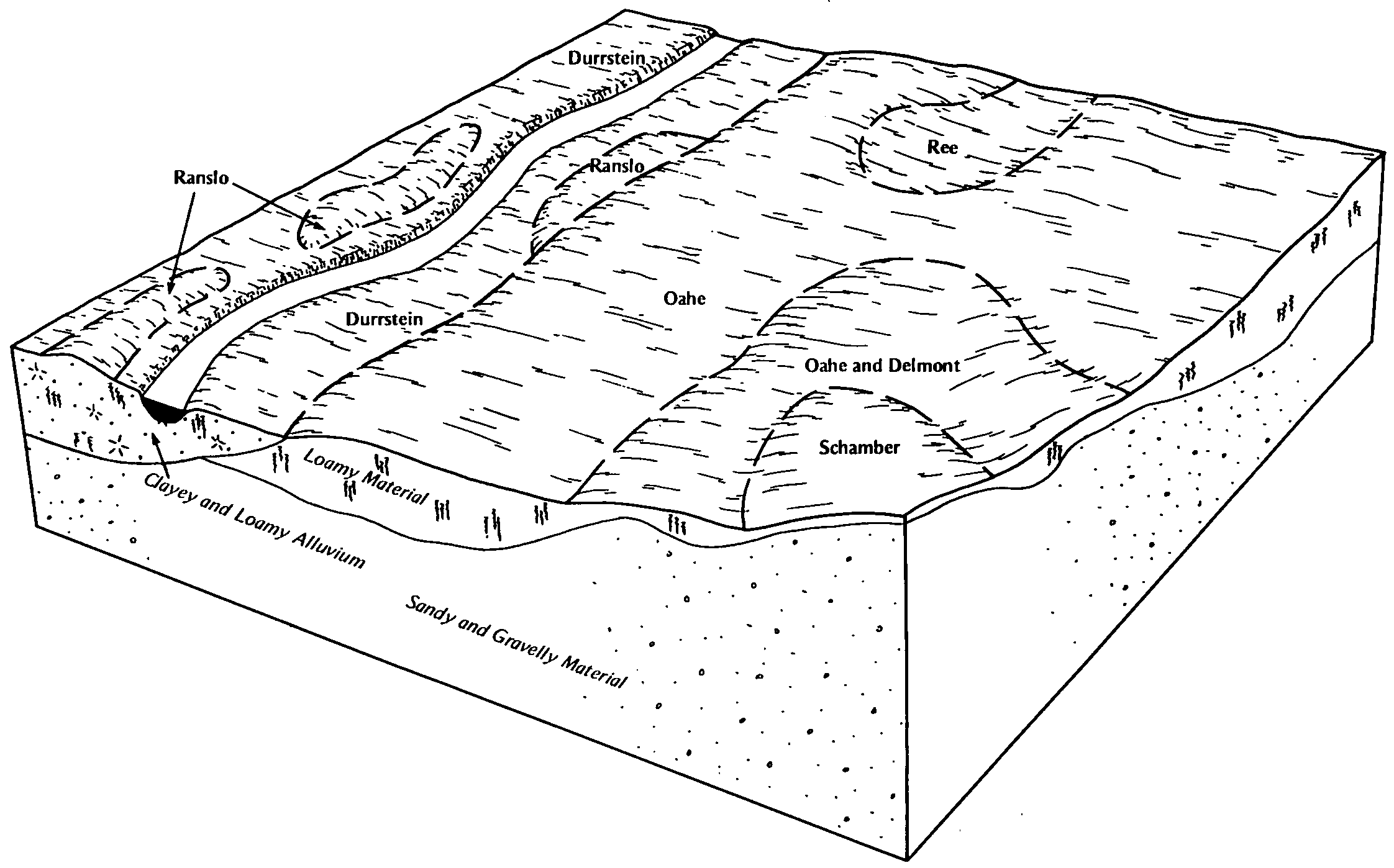
Ree and Durrstein soils | Rt | 1164 | 353126 | cvg5 | sd119 | 1967 | 1:20000 |
Ree loam, 3 to 6 percent slopes | RaB | 14105 | 354433 | 2xfy3 | sd123 | 1975 | 1:20000 |
Ree loam, 6 to 9 percent slopes | RaC | 12581 | 354434 | 2wfqq | sd123 | 1975 | 1:20000 |
Ree loam, 0 to 3 percent slopes | RaA | 10431 | 354432 | 2xfy2 | sd123 | 1975 | 1:20000 |
Ree loam, 9 to 15 percent slopes | RaD | 3633 | 354435 | cwtd | sd123 | 1975 | 1:20000 |
Ree loam, 0 to 3 percent slopes | RaA | 771 | 355866 | 2xfy2 | sd137 | 1985 | 1:24000 |
Ree loam, 3 to 6 percent slopes | RaB | 620 | 355867 | 2xfy3 | sd137 | 1985 | 1:24000 |
Ree loam, 0 to 3 percent slopes | ReA | 6406 | 355540 | cxz1 | sd603 | 1983 | 1:20000 |
Ree loam, 3 to 7 percent slopes | ReB | 4007 | 355541 | cxz2 | sd603 | 1983 | 1:20000 |