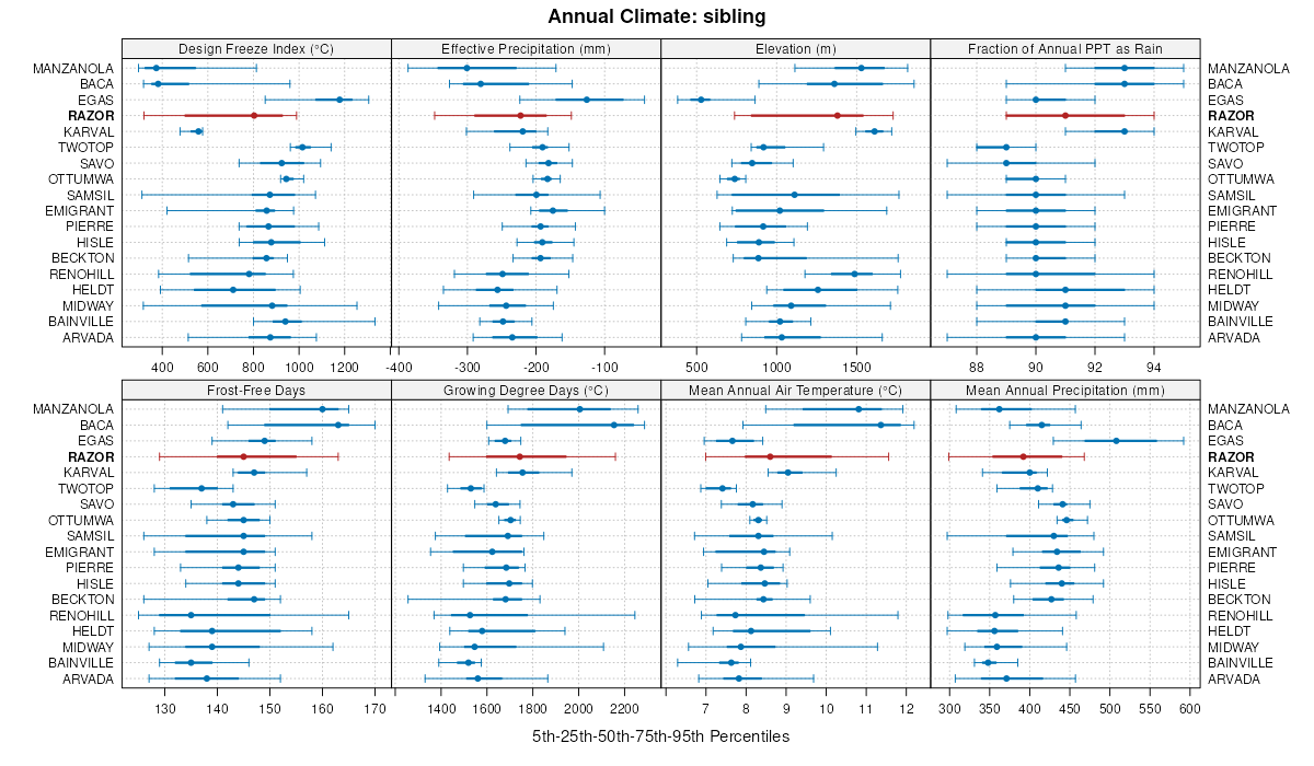
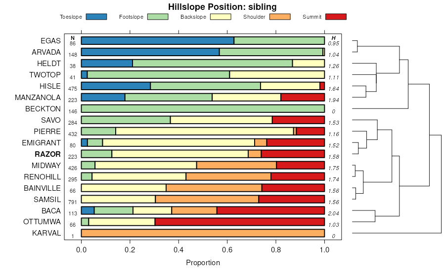
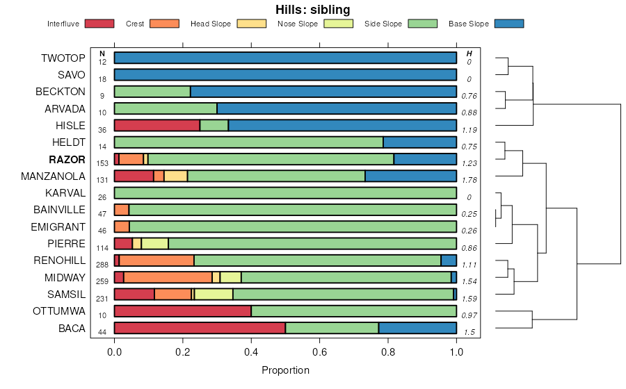
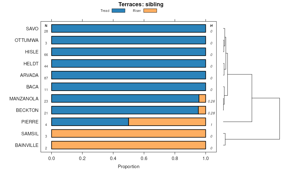
| Razor clay loam, 1 to 6 percent slopes | 35 | 13313 | 94324 | 354q | co017 | 1985 | 1:24000 |
Razor-Midway clay loams, 6 to 12 percent slopes | 36 | 6767 | 94325 | 354r | co017 | 1985 | 1:24000 |
Stoneham-Razor complex, 2 to 6 percent slopes | 44 | 5784 | 94334 | 3551 | co017 | 1985 | 1:24000 |
Midway-Razor clay loams, 5 to 15 percent slopes | 51 | 5623 | 96847 | 37s3 | co063 | 1996 | 1:24000 |
Midway-Razor clay loams, moist, 5 to 15 percent slopes | 154 | 44291 | 105235 | 3jhp | co073 | 2001 | 1:24000 |
Razor clay loam, moist, 1 to 5 percent slopes | 178 | 30154 | 105259 | 3jjg | co073 | 2001 | 1:24000 |
Razor clay loam, dry, 2 to 5 percent slopes | 177 | 19138 | 105258 | 2t529 | co073 | 2001 | 1:24000 |
Fort Collins-Razor, moist, complex, 5 to 15 percent slopes | 128 | 9845 | 105209 | 3jgv | co073 | 2001 | 1:24000 |
Midway-Razor clay loams, dry, 1 to 18 percent slopes | 153 | 7945 | 105234 | 2t52f | co073 | 2001 | 1:24000 |
Fort-Razor complex, 5 to 15 percent slopes | 132 | 1735 | 105213 | 3jgz | co073 | 2001 | 1:24000 |
Razor silty clay, dry, 1 to 4 percent slopes | CaD | 20228 | 94720 | 2t527 | co089 | 1966 | 1:15840 |
Razor-Heldt complex, 3 to 9 percent slopes | 60 | 23481 | 95024 | 35w9 | co121 | 1982 | 1:24000 |
Razor-Midway complex, 9 to 15 percent slopes | 61 | 10156 | 95025 | 35wb | co121 | 1982 | 1:24000 |
Razor-Midway complex, 3 to 9 percent slopes | 39 | 2842 | 95083 | 35y6 | co125 | 1976 | 1:24000 |
Razor clay, 3 to 25 percent slopes | RaE | 3823 | 498752 | jqzs | co622 | 1968 | 1:20000 |
Midway-Razor clay loams, dry, 1 to 18 percent slopes | 127 | 22148 | 2766628 | 2t52f | co625 | 1975 | 1:24000 |
Schamber-Razor complex, 8 to 50 percent slopes | 82 | 18148 | 95447 | 369y | co625 | 1975 | 1:24000 |
Razor-Midway complex | 75 | 10235 | 95439 | 369p | co625 | 1975 | 1:24000 |
Razor stony clay loam, 5 to 15 percent slopes | 74 | 3496 | 95438 | 369n | co625 | 1975 | 1:24000 |
Terry-Razor complex, 3 to 20 percent slopes | 91 | 3147 | 95457 | 36b8 | co625 | 1975 | 1:24000 |
Razor clay loam, 3 to 9 percent slopes | 73 | 2799 | 95437 | 369m | co625 | 1975 | 1:24000 |
Razor clay loam, dry, 2 to 5 percent slopes | 128 | 841 | 2766647 | 2t529 | co625 | 1975 | 1:24000 |
Razor silty clay, 0 to 3 percent slopes, eroded | Re2 | 42877 | 95531 | 2t52d | co626 | 1974 | 1:24000 |
Razor clay loam, dry, 2 to 5 percent slopes | Ra | 18344 | 95530 | 2t529 | co626 | 1974 | 1:24000 |
Razor silty clay, 2 to 20 percent slopes | 69 | 2662 | 496508 | jnnd | co627 | 1980 | 1:24000 |
Razor clay loam, 1 to 12 percent slopes | 68 | 433 | 496507 | jnnc | co627 | 1980 | 1:24000 |
Razor silty clay, dry, 1 to 4 percent slopes | CaC | 26288 | 3390088 | 2t527 | co628 | 2008 | 1:24000 |
Midway-Razor-Rock outcrop complex, dry, 1 to 15 percent slopes | MP | 24997 | 105379 | 2t52h | co628 | 2008 | 1:24000 |
Razor-Heldt-Midway cobbly clay loams, 15 to 30 percent slopes | 127 | 639 | 497404 | jpl9 | co641 | 1980 | 1:24000 |
Razor-Heldt clay loams, 9 to 25 percent slopes | 126 | 493 | 497403 | jpl8 | co641 | 1980 | 1:24000 |
Razor silty clay loam, 3 to 12 percent slopes | 66 | 2677 | 496646 | jnsv | co679 | 1976 | 1:24000 |
Razor-Midway silty clay loams, 5 to 20 percent slopes | 1751 | 6431 | 1149575 | 17l72 | ks023 | 1987 | 1:24000 |
Kim-Razor complex, 3 to 6 percent slopes | 1646 | 1510 | 1149569 | 17l6w | ks023 | 1987 | 1:24000 |
Razor clay, 1 to 6 percent slopes | 1748 | 511 | 1150541 | 17m77 | ks109 | 1962 | 1:24000 |
Razor clay, 1 to 6 percent slopes | 1748 | 2426 | 1150206 | 17lwf | ks199 | 1984 | 1:24000 |
Razor-Cushman complex, 2 to 4 percent slopes | Rc | 1239 | 345787 | cltf | mt111 | 1966 | 1:20000 |
Razor clay loam, 2 to 8 percent slopes | Ra | 1343 | 347118 | cn6c | mt611 | 1971 | 1:24000 |
Razor-Thedalund clay loams, 4 to 15 percent slopes | Rb | 1343 | 347119 | cn6d | mt611 | 1971 | 1:24000 |
Midway-Razor silty clay loams, 3 to 15 percent slopes | MrD | 21923 | 353208 | cvjt | sd019 | 1970 | 1:24000 |
Razor silty clay loam, 2 to 6 percent slopes | RcB | 8857 | 353224 | cvkb | sd019 | 1970 | 1:24000 |
Razor silty clay loam, 6 to 9 percent slopes | RcC | 617 | 353225 | 30wpv | sd019 | 1970 | 1:24000 |
Razor silty clay loam, 0 to 2 percent slopes | RcA | 474 | 353223 | cvk9 | sd019 | 1970 | 1:24000 |
Razor-Midway complex, 6 to 15 percent slopes | RbD | 32068 | 354146 | cwj2 | sd055 | 1992 | 1:24000 |
Ottumwa-Razor silty clays, 6 to 9 percent slopes | OxC | 18422 | 354136 | cwhr | sd055 | 1992 | 1:24000 |
Ottumwa-Razor-Savo complex, 6 to 15 percent slopes | OyC | 12385 | 354137 | cwhs | sd055 | 1992 | 1:24000 |
Razor-Shingle complex, 6 to 15 percent slopes | RdD | 1156 | 354147 | cwj3 | sd055 | 1992 | 1:24000 |
Shingle-Razor complex, 15 to 25 percent slopes | SwE | 149 | 354164 | cwjn | sd055 | 1992 | 1:24000 |
Razor silty clay, 6 to 9 percent slopes | RaC | 53 | 354145 | cwj1 | sd055 | 1992 | 1:24000 |
Razor silty clay, 2 to 6 percent slopes | RaB | 3 | 354144 | cwj0 | sd055 | 1992 | 1:24000 |
Razor-Midway complex, 6 to 15 percent slopes | RbD | 30812 | 2580962 | cyk3 | sd606 | 2011 | 1:24000 |
Ottumwa-Razor complex, 6 to 9 percent slopes | OvC | 8288 | 2580949 | cyjp | sd606 | 2011 | 1:24000 |
Razor silty clay, 6 to 9 percent slopes | RaC | 3940 | 2580961 | cyk2 | sd606 | 2011 | 1:24000 |
Razor silty clay, 2 to 6 percent slopes | RaB | 3396 | 2580960 | cyk1 | sd606 | 2011 | 1:24000 |
Razor-Midway silty clay loams, 6 to 15 percent slopes | RmD | 17472 | 2582663 | cy3y | sd611 | 2011 | 1:24000 |
Emigrant-Razor complex, 6 to 9 percent slopes | ErC | 6421 | 2581017 | cy2g | sd611 | 2011 | 1:24000 |
Emigrant-Razor complex, 9 to 15 percent slopes | ErD | 5295 | 2581018 | cy2h | sd611 | 2011 | 1:24000 |
Emigrant-Razor complex, 1 to 6 percent slopes | ErB | 4719 | 2581016 | cy2f | sd611 | 2011 | 1:24000 |
Razor-Hisle complex, 2 to 9 percent slopes | RhC | 2708 | 2582662 | cy3x | sd611 | 2011 | 1:24000 |
Winler-Razor clay loams, 2 to 10 percent slopes | 206 | 34022 | 349293 | 2y6dc | wy011 | 1978 | 1:24000 |
Razor clay loam, 2 to 10 percent slopes | 141 | 15356 | 349222 | 2y6dk | wy011 | 1978 | 1:24000 |
Samsil-Razor complex, 2 to 10 percent slopes | 158 | 2873 | 349240 | cqdt | wy011 | 1978 | 1:24000 |
Samsil-Razor complex, 10 to 30 percent slopes | 159 | 2709 | 349241 | cqdv | wy011 | 1978 | 1:24000 |
Razor-Samsil complex, 3 to 10 percent slopes | 142 | 2682 | 349223 | 2y6dl | wy011 | 1978 | 1:24000 |
Renohill-Razor-Samsil, dry complex, 6 to 20 percent slopes | RED | 45614 | 350913 | 2xtvf | wy619 | 1971 | 1:24000 |
Razor-Gaynor, dry-Samsil, dry complex, 6 to 30 percent slopes | RAD | 41194 | 350910 | 2xtvj | wy619 | 1971 | 1:24000 |
Renohill-Razor association, undulating | REC | 2405 | 350912 | cs4r | wy619 | 1971 | 1:24000 |