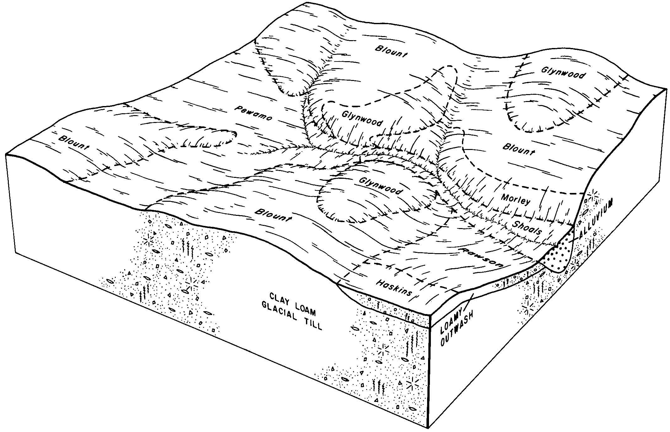
| Rawson loam, 2 to 6 percent slopes | RdB | 1055 | 163444 | 5h2d | in001 | 1983 | 1:15840 |
Rawson loam, 2 to 6 percent slopes, moderately eroded | RlB2 | 2381 | 164743 | 5jf9 | in003 | 1965 | 1:15840 |
Rawson-Urban land complex, 2 to 6 percent slopes, moderately eroded | YrmB2 | 324 | 3404531 | 2zy57 | in003 | 1965 | 1:15840 |
Rawson loam, 6 to 12 percent slopes, moderately eroded | RlC2 | 246 | 164744 | 5jfb | in003 | 1965 | 1:15840 |
Rawson loam, 0 to 2 percent slopes | RlA | 240 | 164742 | 5jf8 | in003 | 1965 | 1:15840 |
Rawson fine sandy loam, 2 to 6 percent slopes | RaB | 168 | 164741 | 5jf7 | in003 | 1965 | 1:15840 |
Rawson-Urban land complex, 6 to 12 percent slopes, moderately eroded | YrmC2 | 83 | 3404532 | 2zy59 | in003 | 1965 | 1:15840 |
Rawson-Urban land complex, 2 to 6 percent slopes | YrmB | 54 | 3404602 | 2zkg9 | in003 | 1965 | 1:15840 |
Urban land-Rawson complex, 2 to 6 percent slopes, moderately eroded | UprB2 | 37 | 3404566 | 2zy56 | in003 | 1965 | 1:15840 |
Rawson-Urban land complex, 0 to 2 percent slopes | YrmA | 34 | 3404530 | 2zy55 | in003 | 1965 | 1:15840 |
Urban land-Rawson complex, 2 to 6 percent slopes | UprB | 11 | 3404601 | 2yc58 | in003 | 1965 | 1:15840 |
Rawson sandy loam, 2 to 6 percent slopes | RaB | 6397 | 160339 | 5cv7 | in033 | 1980 | 1:15840 |
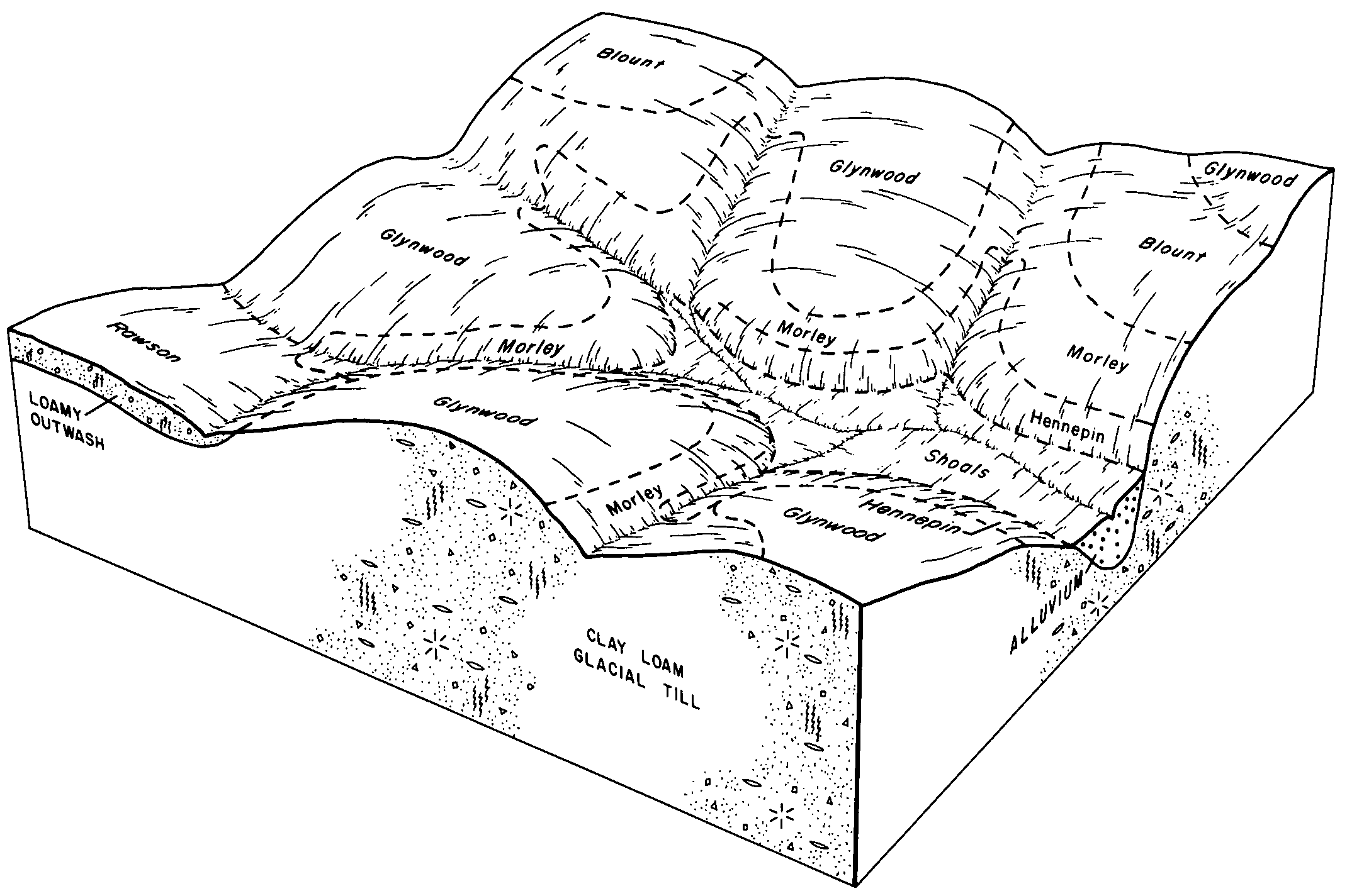
Rawson loam, 1 to 5 percent slopes | RrwB | 717 | 164961 | 5jnb | in035 | 1997 | 1:12000 |
Rawson fine sandy loam, 2 to 6 percent slopes | RgB | 1411 | 161432 | 5dzh | in069 | 1980 | 1:15840 |
Rawson fine sandy loam, 6 to 12 percent slopes | RgC | 270 | 161433 | 5dzj | in069 | 1980 | 1:15840 |
Rawson sandy loam, 2 to 6 percent slopes | RaB | 738 | 272630 | 94pj | in087 | 1978 | 1:20000 |
Rawson loam, 2 to 6 percent slopes | RbB | 7395 | 272570 | 94ml | in113 | 1974 | 1:15840 |
Rawson, Morley, and Miami loams, 2 to 6 percent slopes, eroded | RdB2 | 4588 | 272571 | 94mm | in113 | 1974 | 1:15840 |
Rawson sandy loam, 2 to 6 percent slopes | RaB | 3511 | 272567 | 94mh | in113 | 1974 | 1:15840 |
Rawson sandy loam, 6 to 12 percent slopes, eroded | RaC2 | 1160 | 272568 | 94mj | in113 | 1974 | 1:15840 |
Rawson loam, 0 to 2 percent slopes | RbA | 984 | 272569 | 94mk | in113 | 1974 | 1:15840 |
Morley, Miami, and Rawson loams, 6 to 12 percent slopes, eroded | MuC2 | 941 | 272560 | 94m8 | in113 | 1974 | 1:15840 |
Rawson loam, 2 to 6 percent slopes | RaB | 3438 | 160678 | 5d65 | in127 | 1978 | 1:15840 |
Rawson loam, 6 to 12 percent slopes, eroded | RaC2 | 671 | 160679 | 5d66 | in127 | 1978 | 1:15840 |
Rawson loam, 2 to 6 percent slopes | RaB | 5048 | 160237 | 5cqy | in151 | 1979 | 1:20000 |
Rawson sandy loam, 2 to 6 percent slopes, eroded | RcB2 | 3628 | 161226 | 5drv | in169 | 1980 | 1:15840 |
Rawson sandy loam, 0 to 2 percent slopes | RcA | 652 | 161225 | 5drt | in169 | 1980 | 1:15840 |
Rawson sandy loam, 6 to 12 percent slopes, eroded | RcC2 | 439 | 161227 | 5drw | in169 | 1980 | 1:15840 |
Rawson fine sandy loam, 2 to 6 percent slopes | RlB | 944 | 161272 | 5dtb | in179 | 1988 | 1:15840 |
Rawson fine sandy loam, 6 to 12 percent slopes | RlC | 50 | 161273 | 5dtc | in179 | 1988 | 1:15840 |
Rawson-Urban land complex, 2 to 6 percent slopes | YrlB | 6 | 3216874 | 2zkg9 | in179 | 1988 | 1:15840 |
Rawson sandy loam, 2 to 6 percent slopes | RcB | 6908 | 161812 | 5fcr | in183 | 1985 | 1:15840 |
Rawson sandy loam, 6 to 12 percent slopes | RcC | 1617 | 161813 | 5fcs | in183 | 1985 | 1:15840 |
Rawson sandy loam, 0 to 2 percent slopes | RcA | 851 | 161811 | 5fcq | in183 | 1985 | 1:15840 |
Rawson sandy loam, 2 to 6 percent slopes | RsB | 4 | 2509149 | 5nz2 | mi091 | 1957 | 1:20000 |
Rawson loam, 2 to 6 percent slopes | RoB | 1 | 1592665 | 1qg99 | oh005 | 1976 | 1:15840 |
Rawson sandy loam, 2 to 6 percent slopes | RmB | 1093 | 168465 | 5n9c | oh039 | 1981 | 1:15840 |
Rawson loam, 6 to 12 percent slopes | RkC | 1 | 1539765 | 1np7v | oh039 | 1981 | 1:15840 |
Rawson sandy loam, 6 to 12 percent slopes | RmC | 1 | 1539766 | 1np7w | oh039 | 1981 | 1:15840 |
Rawson sandy loam, 2 to 6 percent slopes | RcB | 1110 | 172177 | 5s53 | oh043 | 1998 | 1:12000 |
Rawson sandy loam, 0 to 2 percent slopes | RcA | 598 | 172176 | 5s52 | oh043 | 1998 | 1:12000 |
Rawson sandy loam, 2 to 6 percent slopes | RbB | 1851 | 169107 | 5nz2 | oh051 | 1981 | 1:15840 |
Rawson silt loam, 2 to 6 percent slopes | RmB | 4728 | 287585 | 9n7y | oh055 | 1979 | 1:15840 |
Rawson sandy loam, 2 to 6 percent slopes | RgB | 117 | 644443 | pmlh | oh063 | 1997 | 1:12000 |
Rawson loam, 2 to 6 percent slopes | RdB | 129 | 169031 | 5nwm | oh069 | 1968 | 1:15840 |
Rawson sandy loam, 2 to 6 percent slopes | RaB | 106 | 169030 | 5nwl | oh069 | 1968 | 1:15840 |
Haney and Rawson loams, 6 to 12 percent slopes | HeC | 92 | 168999 | 5nvl | oh069 | 1968 | 1:15840 |
Rawson fine sandy loam, stratified substratum, 2 to 6 percent slopes | ReB | 85 | 169032 | 5nwn | oh069 | 1968 | 1:15840 |
Rawson loam, 2 to 6 percent slopes | RdB | 1042 | 287806 | 9nh2 | oh093 | 1972 | 1:15840 |
Rawson loam, 0 to 2 percent slopes | RdA | 954 | 287805 | 9nh1 | oh093 | 1972 | 1:15840 |
Rawson loam, 6 to 12 percent slopes, moderately eroded | RdC2 | 117 | 287807 | 9nh3 | oh093 | 1972 | 1:15840 |
Rawson loam, 2 to 6 percent slopes | RoB | 599 | 288381 | 9p2m | oh103 | 1974 | 1:15840 |
Rawson loam, 6 to 12 percent slopes, moderately eroded | RoC2 | 3 | 1412550 | 1jdw4 | oh103 | 1974 | 1:15840 |
Rawson loam, 2 to 6 percent slopes | RmB | 645 | 169956 | 5pvg | oh107 | 1975 | 1:15840 |
Urban land-Rawson complex, 2 to 6 percent slopes | RuB | 3 | 3216921 | 2yc58 | oh107 | 1975 | 1:15840 |
Rawson silt loam, 2 to 6 percent slopes | RaB | 1595 | 537930 | l1rl | oh119 | 1989 | 1:15840 |
Rawson loam, 2 to 6 percent slopes | RaB | 882 | 170401 | 5q9t | oh123 | 1981 | 1:15840 |
Rawson loam, 2 to 6 percent slopes | RmB | 802 | 170674 | 5qlm | oh137 | 1971 | 1:20000 |
Rawson loam, 0 to 2 percent slopes | RmA | 200 | 170673 | 5qll | oh137 | 1971 | 1:20000 |
Rawson loam, 6 to 12 percent slopes, moderately eroded | RmC2 | 113 | 170675 | 5qln | oh137 | 1971 | 1:20000 |
Rawson loam, 2 to 6 percent slopes | RmB | 2285 | 170008 | 5px4 | oh147 | 1978 | 1:15840 |
Rawson silt loam, 2 to 6 percent slopes | RdB | 3765 | 287135 | 9msf | oh155 | 1986 | 1:15840 |
Rawson loam, 2 to 6 percent slopes | RmB | 230 | 168115 | 5my2 | oh161 | 1967 | 1:15840 |
Rawson silt loam, 2 to 6 percent slopes | RgB | 1063 | 287221 | 9mw6 | oh169 | 1981 | 1:15840 |
Rawson sandy loam, 2 to 6 percent slopes | RlB | 2330 | 168188 | 5n0f | oh171 | 1975 | 1:15840 |
Rawson loam, 2 to 6 percent slopes | RmB | 1151 | 168190 | 5n0h | oh171 | 1975 | 1:15840 |
Haney-Rawson sandy loams, 1 to 6 percent slopes | HeB | 748 | 168161 | 5mzk | oh171 | 1975 | 1:15840 |
Rawson loam, 6 to 12 percent slopes | RmC | 336 | 168191 | 5n0j | oh171 | 1975 | 1:15840 |
Rawson sandy loam, 6 to 12 percent slopes | RlC | 288 | 168189 | 5n0g | oh171 | 1975 | 1:15840 |
Haney-Rawson sandy loams, 6 to 12 percent slopes | HeC | 236 | 168162 | 5mzl | oh171 | 1975 | 1:15840 |


