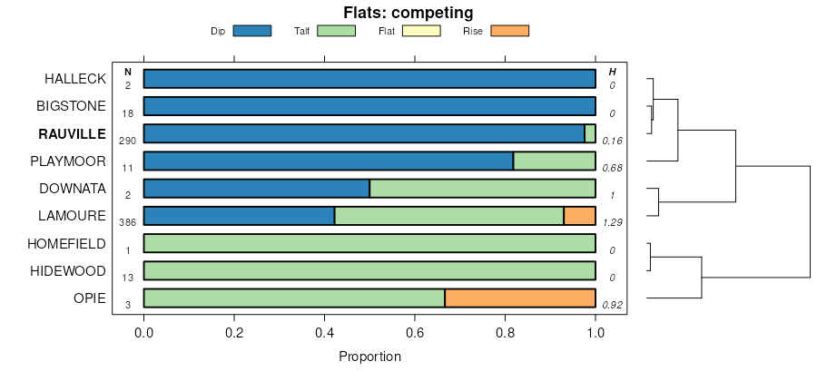
| Rauville silty clay loam, 0 to 2 percent slopes, frequently flooded | 450 | 5757 | 396094 | 2w0ms | mn011 | 1990 | 1:20000 |
Rauville silty clay loam, 0 to 2 percent slopes, frequently flooded | J25A | 3204 | 3026594 | 2w0ms | mn023 | 1980 | 1:15840 |
Rauville silty clay loam, 0 to 2 percent slopes, frequently flooded | I49A | 1691 | 2798073 | prp4 | mn027 | 1980 | 1:20000 |
Rauville silty clay loam, 0 to 2 percent slopes, frequently flooded | I49A | 84 | 2798178 | prp4 | mn051 | 1974 | 1:20000 |
Rauville silty clay loam, 0 to 2 percent slopes, frequently flooded | 450 | 6506 | 430315 | 2w0ms | mn073 | 1994 | 1:20000 |
Rauville silty clay loam, 0 to 1 percent slopes, frequently flooded | J25A | 1069 | 991446 | 128p4 | mn081 | 2007 | 1:12000 |
Rauville silty clay loam, coteau, 0 to 1 percent slopes, frequently flooded | Z150A | 545 | 2765340 | 2qjmv | mn081 | 2007 | 1:12000 |
Rauville silty clay loam, 0 to 1 percent slopes, frequently flooded | J25A | 1115 | 1486224 | 1lwjq | mn083 | 2008 | 1:12000 |
Rauville silty clay loam | 450 | 1047 | 1859048 | 20dh9 | mn083 | 2008 | 1:12000 |
Rauville silty clay loam, coteau, 0 to 1 percent slopes, frequently flooded | Z150A | 2327 | 2765327 | 2qjmv | mn117 | 2005 | 1:12000 |
Rauville silty clay loam, 0 to 1 percent slopes, frequently flooded | J25A | 1172 | 780494 | v657 | mn117 | 2005 | 1:12000 |
Rauville silty clay loam, 0 to 2 percent slopes, frequently flooded | I49A | 2260 | 2799668 | prp4 | mn119 | 1996 | 1:20000 |
Rauville silty clay loam, 0 to 2 percent slopes, frequently flooded | I49A | 303 | 2799796 | prp4 | mn125 | 2001 | 1:12000 |
Rauville silty clay loam, 0 to 2 percent slopes, frequently flooded | Ra | 320 | 428367 | 2w0ms | mn149 | 1966 | 1:15840 |
Rauville silty clay loam, 0 to 2 percent slopes, frequently flooded | J25A | 6918 | 434802 | 2w0ms | mn151 | 2000 | 1:12000 |
Rauville silty clay loam, 0 to 2 percent slopes, frequently flooded | I49A | 1387 | 2799933 | prp4 | mn155 | 1986 | 1:20000 |
Rauville silty clay loam, 0 to 2 percent slopes, frequently flooded | 450 | 246 | 357364 | 2w0ms | mn155 | 1986 | 1:20000 |
Rauville silty clay loam, 0 to 2 percent slopes, frequently flooded | I49A | 57 | 2799989 | prp4 | mn167 | 1985 | 1:20000 |
Rauville silty clay loam, 0 to 1 percent slopes, frequently flooded | G52A | 5 | 2573582 | 2q3v7 | nd003 | 1988 | 1:20000 |
Rauville silty clay loam, ponded, 0 to 1 percent slopes, frequently flooded | G53A | 919 | 2573781 | 2q3v9 | nd005 | | 1:12000 |
Rauville silty clay loam, 0 to 1 percent slopes, frequently flooded | G52A | 437 | 2573676 | 2q3v7 | nd005 | | 1:12000 |
Rauville silty clay loam, 0 to 1 percent slopes, frequently flooded | I370A | 2308 | 2640855 | 1nyxy | nd017 | 1983 | 1:20000 |
Rauville silty clay loam, 0 to 1 percent slopes, frequently flooded | G52A | 595 | 2575269 | 2q3v7 | nd021 | 1989 | 1:20000 |
Rauville silty clay loam, ponded, 0 to 1 percent slopes, frequently flooded | G53A | 389 | 2575270 | 2q3v9 | nd021 | 1989 | 1:20000 |
Rauville silty clay loam, ponded, 0 to 1 percent slopes, frequently flooded | G53A | 249 | 2575413 | 2q3v9 | nd027 | | 1:12000 |
Rauville silty clay loam, 0 to 1 percent slopes, frequently flooded | G52A | 198 | 2575412 | 2q3v7 | nd027 | | 1:12000 |
Rauville silty clay loam, 0 to 1 percent slopes, frequently flooded | G52A | 33 | 2576383 | 2q3v7 | nd031 | 1990 | 1:20000 |
Rauville silty clay loam, 0 to 1 percent slopes, frequently flooded | I370A | 4711 | 2642552 | 1nyxy | nd035 | 1980 | 1:20000 |
Rauville silty clay loam, 0 to 1 percent slopes, frequently flooded | G52A | 386 | 2576571 | 2q3v7 | nd039 | 1991 | 1:24000 |
Rauville silty clay loam, 0 to 1 percent slopes, frequently flooded | G52A | 1328 | 2577031 | 2q3v7 | nd045 | 1966 | 1:20000 |
Rauville silty clay loam, ponded, 0 to 1 percent slopes, frequently flooded | G53A | 91 | 2577033 | 2q3v9 | nd045 | 1966 | 1:20000 |
Rauville silty clay loam, ponded, 0 to 1 percent slopes, frequently flooded | G53A | 634 | 2577258 | 2q3v9 | nd063 | | 1:12000 |
Rauville silty clay loam, 0 to 1 percent slopes, frequently flooded | G52A | 448 | 2577257 | 2q3v7 | nd063 | | 1:12000 |
Rauville silty clay loam, 0 to 1 percent slopes, frequently flooded | I370A | 2625 | 2642973 | 1nyxy | nd067 | 1972 | 1:20000 |
Rauville silty clay loam, ponded, 0 to 1 percent slopes, frequently flooded | G53A | 336 | 2582260 | 2q3v9 | nd069 | 1975 | 1:20000 |
Rauville silty clay loam, wooded, 0 to 1 percent slopes, frequently flooded | I445A | 1226 | 2641321 | 1nz02 | nd073 | 1992 | 1:20000 |
Rauville silty clay loam, 0 to 1 percent slopes, frequently flooded | G52A | 299 | 2581128 | 2q3v7 | nd073 | 1992 | 1:20000 |
Rauville silty clay loam, 0 to 1 percent slopes, frequently flooded | I370A | 216 | 2641300 | 1nyxy | nd073 | 1992 | 1:20000 |
Rauville silty clay loam, 0 to 1 percent slopes, frequently flooded | I370A | 564 | 2641052 | 1nyxy | nd077 | 2005 | 1:12000 |
Rauville silty clay loam, wooded, 0 to 1 percent slopes, frequently flooded | I445A | 138 | 2641041 | 1nz02 | nd077 | 2005 | 1:12000 |
Rauville silty clay loam, 0 to 1 percent slopes, frequently flooded | I370A | 374 | 2641224 | 1nyxy | nd081 | 1959 | 1:12000 |
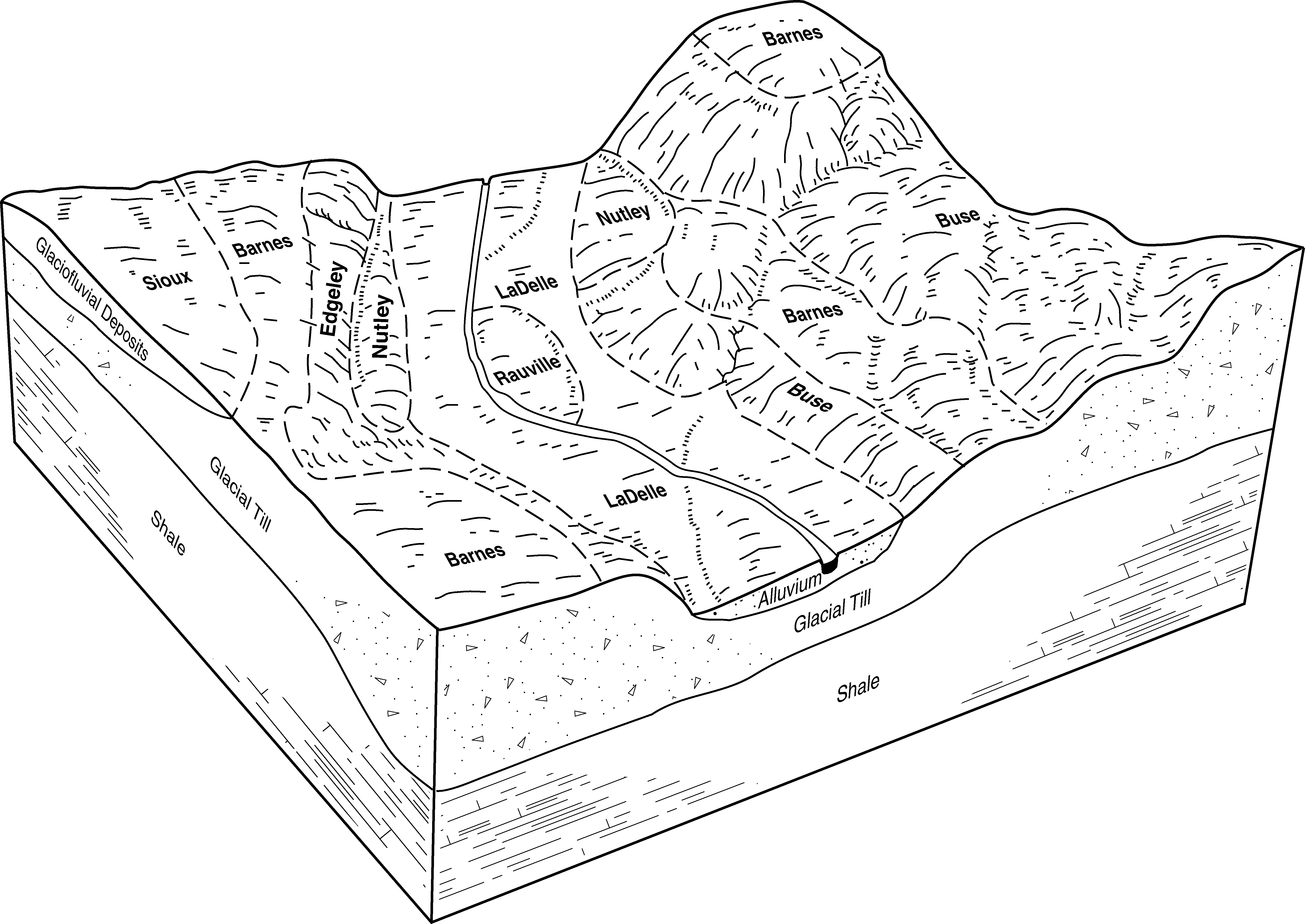
Rauville soils | Ra | 168 | 341619 | cggz | nd081 | 1959 | 1:12000 |
Rauville silty clay loam, ponded, 0 to 1 percent slopes, frequently flooded | G53A | 166 | 2579520 | 2q3v9 | nd081 | 1959 | 1:12000 |
Rauville silty clay loam, 0 to 1 percent slopes, frequently flooded | G52A | 49 | 2579432 | 2q3v7 | nd081 | 1959 | 1:12000 |
Rauville silty clay loam, 0 to 1 percent slopes, frequently flooded | G52A | 889 | 2581335 | 2q3v7 | nd093 | 1990 | 1:24000 |
Rauville silty clay loam, ponded, 0 to 1 percent slopes, frequently flooded | G53A | 236 | 2581337 | 2q3v9 | nd093 | 1990 | 1:24000 |
Rauville silty clay loam, 0 to 1 percent slopes, frequently flooded | I370A | 6 | 2641612 | 1nyxy | nd097 | 1974 | 1:20000 |
Rauville silty clay loam, 0 to 1 percent slopes, frequently flooded | I370A | 766 | 2642847 | 1nyxy | nd099 | 1967 | 1:20000 |
Rauville silty clay loam, ponded, 0 to 1 percent slopes, frequently flooded | G53A | 135 | 2579601 | 2q3v9 | nd103 | 1966 | 1:12000 |
Rauville silty clay loam, 0 to 1 percent slopes, frequently flooded | G52A | 54 | 2579599 | 2q3v7 | nd103 | 1966 | 1:12000 |
Lamoure-Rauville silty clay loams, channeled, 0 to 2 percent slopes, frequently flooded | Z153A | 18458 | 2765294 | 2qjmx | sd011 | 1995 | 1:24000 |
Rauville silty clay loam, coteau, 0 to 1 percent slopes, frequently flooded | Z150A | 2356 | 2765292 | 2qjmv | sd011 | 1995 | 1:24000 |
Lamoure-Rauville silty clay loams, channeled | Lm | 1535 | 418774 | g1rv | sd011 | 1995 | 1:24000 |
Rauville mucky silty clay loam, ponded, 0 to 1 percent slopes, frequently flooded | Z250A | 1486 | 2765319 | 2qkmf | sd011 | 1995 | 1:24000 |
Rauville silty clay loam, 0 to 1 percent slopes | Ra | 410 | 418796 | g1sk | sd011 | 1995 | 1:24000 |
Rauville silty clay loam, ponded | Rp | 34 | 418797 | g1sl | sd011 | 1995 | 1:24000 |
Rauville silty clay loam, ponded, 0 to 1 percent slopes, frequently flooded | G053A | 2676 | 2797641 | 2q3v9 | sd013 | 1987 | 1:20000 |
Rauville silty clay loam, 0 to 1 percent slopes, frequently flooded | G052A | 1605 | 2797639 | 2q3v7 | sd013 | 1987 | 1:20000 |
Rauville silty clay loam | Re | 1125 | 417779 | g0qr | sd025 | 1992 | 1:20000 |
Lamoure-Rauville silty clay loams, channeled, 0 to 2 percent slopes, frequently flooded | Z153A | 5899 | 2713011 | 2qjmx | sd029 | 2006 | 1:12000 |
Rauville silty clay loam, coteau, 0 to 1 percent slopes, frequently flooded | Z150A | 3485 | 2713009 | 2qjmv | sd029 | 2006 | 1:12000 |
Rauville mucky silty clay loam, ponded, 0 to 1 percent slopes, frequently flooded | Z250A | 1489 | 2765257 | 2qkmf | sd029 | 2006 | 1:12000 |
Rauville silty clay loam | Rb | 990 | 417124 | g01m | sd037 | 1992 | 1:20000 |
Rauville silty clay loam, coteau, 0 to 1 percent slopes, frequently flooded | Z150A | 506 | 2765394 | 2qjmv | sd037 | 1992 | 1:20000 |
Rauville silty clay loam, 0 to 1 percent slopes, frequently flooded | G052A | 21 | 2798443 | 2q3v7 | sd037 | 1992 | 1:20000 |
Lamoure-Rauville silty clay loams, channeled | Lr | 7643 | 416873 | fzsj | sd039 | 1992 | 1:20000 |
Rauville silty clay loam, coteau, 0 to 1 percent slopes, frequently flooded | Z150A | 3222 | 2712953 | 2qjmv | sd039 | 1992 | 1:20000 |
Lamoure-Rauville silty clay loams, channeled, 0 to 2 percent slopes, frequently flooded | Z153A | 3061 | 2712955 | 2qjmx | sd039 | 1992 | 1:20000 |
Rauville silty clay loam, 0 to 2 percent slopes, frequently flooded | Rc | 235 | 416893 | 2w0ms | sd039 | 1992 | 1:20000 |
Rauville mucky silty clay loam, ponded, 0 to 1 percent slopes, frequently flooded | Z250A | 104 | 2712981 | 2qkmf | sd039 | 1992 | 1:20000 |
Rauville silty clay loam, coteau, 0 to 1 percent slopes, frequently flooded | Z150A | 2670 | 2712865 | 2qjmv | sd051 | 1977 | 1:20000 |
Lamoure-Rauville silty clay loams, channeled, 0 to 2 percent slopes, frequently flooded | Z153A | 2228 | 2712867 | 2qjmx | sd051 | 1977 | 1:20000 |
Rauville mucky silty clay loam, ponded, 0 to 1 percent slopes, frequently flooded | Z250A | 797 | 2712913 | 2qkmf | sd051 | 1977 | 1:20000 |
Rauville silty clay loam, 0 to 2 percent slopes, frequently flooded | Ra | 427 | 418179 | 2w0ms | sd051 | 1977 | 1:20000 |
Lamoure-Rauville silty clay loams, channeled, 0 to 2 percent slopes, frequently flooded | Z153A | 2977 | 2765383 | 2qjmx | sd057 | 1992 | 1:20000 |
Lamoure-Rauville silty clay loams, channeled | Lr | 2491 | 417289 | g06y | sd057 | 1992 | 1:20000 |
Rauville silty clay loam, coteau, 0 to 1 percent slopes, frequently flooded | Z150A | 1895 | 2765354 | 2qjmv | sd057 | 1992 | 1:20000 |
Rauville mucky silty clay loam, ponded, 0 to 1 percent slopes, frequently flooded | Z250A | 1239 | 2765387 | 2qkmf | sd057 | 1992 | 1:20000 |
Rauville silty clay loam | Ra | 425 | 417307 | g07j | sd057 | 1992 | 1:20000 |
Lamoure-Rauville silty clay loams, channeled, 0 to 2 percent slopes, frequently flooded | Z153A | 49 | 2712841 | 2qjmx | sd077 | 1992 | 1:20000 |
Rauville silty clay loam | Ra | 4109 | 416511 | fzdv | sd079 | 1967 | 1:20000 |
Rauville silty clay loam | Wa | 3147 | 416618 | fzj9 | sd091 | 1970 | 1:20000 |
Rauville silty clay loam, 0 to 1 percent slopes, frequently flooded | G052A | 272 | 2799271 | 2q3v7 | sd091 | 1970 | 1:20000 |
Rauville silty clay loam, ponded, 0 to 1 percent slopes, frequently flooded | G053A | 224 | 2799273 | 2q3v9 | sd091 | 1970 | 1:20000 |
Lamoure-Rauville silty clay loams, channeled, 0 to 2 percent slopes, frequently flooded | Z153A | 2860 | 2712826 | 2qjmx | sd101 | 1985 | 1:20000 |
Rauville silty clay loam, coteau, 0 to 1 percent slopes, frequently flooded | Z150A | 471 | 2712824 | 2qjmv | sd101 | 1985 | 1:20000 |
Rauville silty clay loam, 0 to 2 percent slopes, frequently flooded | Ra | 2023 | 417861 | 2w0ms | sd109 | 1977 | 1:20000 |
Rauville silty clay loam, coteau, 0 to 1 percent slopes, frequently flooded | Z150A | 770 | 2712779 | 2qjmv | sd109 | 1977 | 1:20000 |
Lamoure-Rauville silty clay loams, channeled, 0 to 2 percent slopes, frequently flooded | Z153A | 681 | 2712781 | 2qjmx | sd109 | 1977 | 1:20000 |
Rauville mucky silty clay loam, ponded, 0 to 1 percent slopes, frequently flooded | Z250A | 360 | 2712802 | 2qkmf | sd109 | 1977 | 1:20000 |
Rauville silty clay loam, 0 to 1 percent slopes, frequently flooded | G052A | 3292 | 2799537 | 2q3v7 | sd115 | 1997 | 1:24000 |
Rauville silty clay loam, ponded, 0 to 1 percent slopes, frequently flooded | G053A | 1915 | 2799538 | 2q3v9 | sd115 | 1997 | 1:24000 |