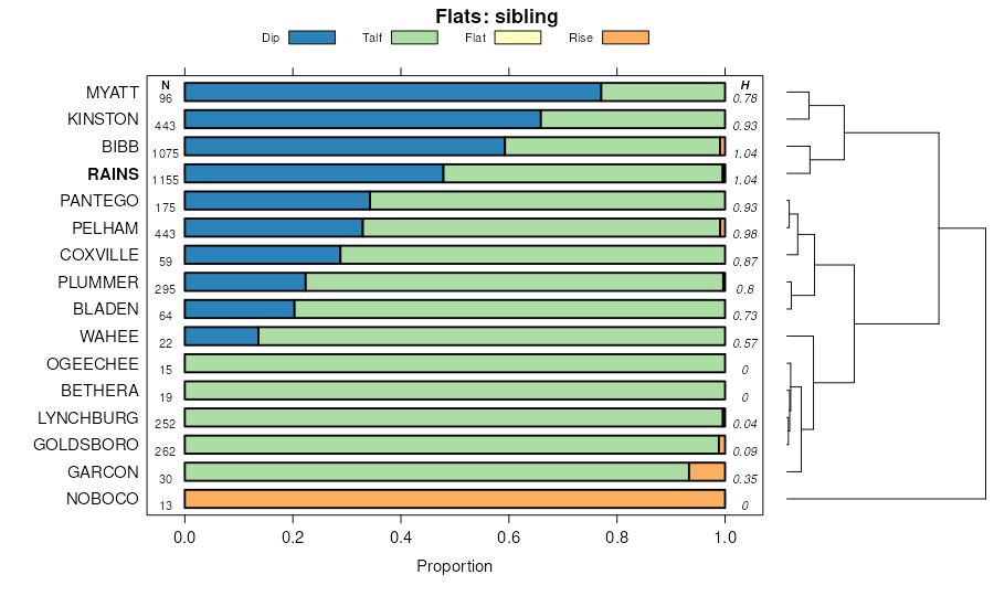
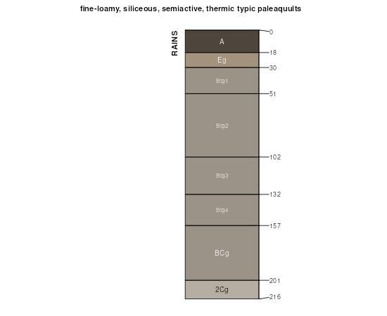
| Rains fine sandy loam | Ra | 7273 | 328085 | c0dd | al001 | 1972 | 1:20000 |
Rains fine sandy loam, 2 to 5 percent slopes | RaB | 16797 | 328192 | c0hv | al003 | 1961 | 1:20000 |
Rains fine sandy loam, 0 to 2 percent slopes | RaA | 15203 | 328191 | c0ht | al003 | 1961 | 1:20000 |
Rains fine sandy loam, 5 to 8 percent slopes | RaC | 944 | 328193 | c0hw | al003 | 1961 | 1:20000 |
Rains-Bethera complex, 0 to 1 percent slopes, occasionally flooded | RbA | 32620 | 328474 | 2tl18 | al013 | 1996 | 1:20000 |
Rains sandy loam, 0 to 2 percent slopes | RaA | 2330 | 328473 | c0sx | al013 | 1996 | 1:20000 |
Rains-Bethera complex, 0 to 2 percent slopes, frequently flooded | RbA | 8293 | 328779 | c13s | al039 | 1985 | 1:20000 |
Rains sandy loam, 0 to 2 percent slopes | RaA | 8159 | 328778 | c13r | al039 | 1985 | 1:20000 |
Rains-Bethera complex, 0 to 1 percent slopes, occasionally flooded | RbA | 2580 | 330519 | 2tl18 | al041 | 2005 | 1:24000 |
Rains and Plummer soils, level | RaA | 1055 | 329013 | c1cb | al045 | 1958 | 1:20000 |
Rains and Plummer soils, 5 to 20 percent slopes | RaD | 351 | 329014 | c1cc | al045 | 1958 | 1:20000 |
Rains loamy sand | Ra | 1221 | 329284 | c1n2 | al051 | 1948 | 1:20000 |
Rains sandy loam | Ra | 8510 | 329637 | c20g | al061 | 1973 | 1:20000 |
Rains fine sandy loam, 0 to 2 percent slopes | RaA | 228 | 2514916 | 2qdh4 | al085 | 2011 | 1:24000 |
Rains fine sandy loam | Ra | 3826 | 330949 | c3cs | al101 | 1958 | 1:20000 |
Rains loamy fine sand | 44 | 1010 | 1444902 | 1khjr | fl003 | 1991 | 1:20000 |
Rains sand | 37 | 1962 | 320824 | brv5 | fl005 | 1982 | 1:20000 |
Bibb-Rains-Garcon complex, occasionally flooded | 89 | 3648 | 1381628 | 1hcpn | fl039 | 2006 | 1:12000 |
Rains fine sandy loam | 52 | 1076 | 1381592 | 1hcnh | fl039 | 2006 | 1:12000 |
Rains fine sandy loam | 32 | 20665 | 1472753 | 1lfj5 | fl045 | 1997 | 1:24000 |
Rains fine sandy loam | 10 | 2800 | 700473 | rhwx | fl065 | 1984 | 1:20000 |
Rains and Bladen soils | 5 | 15920 | 322739 | btty | fl077 | 2004 | 1:24000 |
Bibb, Rains, and Garcon Soils, occasionally flooded | 95 | 550 | 1379922 | 1h9xm | fl077 | 2004 | 1:24000 |
Rains fine sandy loam | 37 | 3470 | 823784 | wn6p | fl113 | 1978 | 1:20000 |
Rains and Bayboro soils, depressional | 90 | 9180 | 2398485 | 2lhth | fl133 | 2009 | 1:12000 |
Rains loamy fine sand | Ra | 928 | 640598 | phlg | fl609 | 1968 | 1:24000 |
Bladen and Rains soils and swamp | Brs | 27780 | 324519 | bwpc | ga031 | 1965 | 1:20000 |
Rains sandy loam | Ros | 3625 | 324556 | bwqk | ga031 | 1965 | 1:20000 |
Rains sandy loam | Ra | 18063 | 324605 | bws4 | ga033 | 1982 | 1:20000 |
Rains loamy sand, 0 to 2 percent slopes | RaA | 6175 | 1701107 | 1v34f | ga103 | 2007 | 1:24000 |
Rains sandy loam | Ros | 25315 | 324823 | bx05 | ga165 | 1966 | 1:20000 |
Rains loamy sand | Ra | 1950 | 324900 | bx2n | ga245 | 1979 | 1:15840 |
Rains-Urban land complex | Rh | 450 | 324901 | bx2p | ga245 | 1979 | 1:15840 |
Rains loamy sand, 0 to 2 percent slopes | RaA | 15370 | 2580379 | 2qdy9 | ga251 | 2011 | 1:24000 |
Rains sandy loam, 0 to 2 percent slopes, occasionally flooded | RaA | 415 | 2425409 | 2mdv0 | ga259 | 2009 | 1:12000 |
Rains loamy fine sand | Ra | 1772 | 324948 | bx46 | ga277 | 1979 | 1:20000 |
Rains sandy loam, thick surface, 2 to 5 percent slopes | ReB | 2115 | 324991 | bx5l | ga283 | 1962 | 1:20000 |
Ogeechee, Rains, and Pelham soils, 0 to 3 percent slopes, occasionally flooded | ORA | 2445 | 2408369 | 2lv3b | ga299 | 2008 | 1:24000 |
Wahee, Ogeechee, and Rains soils, 0 to 3 percent slopes, occasionally flooded | WRA | 510 | 2408385 | 2lv3v | ga299 | 2008 | 1:24000 |
Rains (pelham) loamy sand, thick surface | RfA | 9015 | 125103 | 465l | ga305 | 1962 | 1:20000 |
Tifton (fuquay) loamy sand, thick surface, 0 to 2 percent slopes | TrA | 3795 | 125113 | 465x | ga305 | 1962 | 1:20000 |
Rains sandy loam, 0 to 2 percent slopes, occasionally flooded | RaA | 95 | 2455433 | 2nf2j | ga307 | 2009 | 1:12000 |
Rains loamy fine sand | RfA | 1466 | 325214 | bxds | ga608 | 1965 | 1:20000 |
Rains fine sandy loam, 0 to 2 percent slopes, frequently flooded | Ros | 2535 | 125361 | 2t1p9 | ga609 | 1967 | 1:20000 |
Rains sandy loam | Ra | 10999 | 325397 | bxlp | ga610 | 1992 | 1:20000 |
Wahee-Ogeechee complex, 0 to 3 percent slopes, occasionally flooded | WaA | 1470 | 2686770 | 2rz8q | ga611 | 2012 | 1:24000 |
Rains loamy sand | Ra | 9130 | 325449 | bxnc | ga612 | 1975 | 1:20000 |
Rains loamy sand | Ra | 12605 | 325498 | bxpy | ga615 | 1981 | 1:20000 |
Rains fine sandy loam, 0 to 2 percent slopes | Ra | 13400 | 125417 | 2tzkl | ga616 | 1977 | 1:20000 |
Rains fine sandy loam | Ros | 7510 | 325567 | bxs5 | ga627 | 1970 | 1:20000 |
Rains loamy fine sand | Ra | 6747 | 325610 | bxtk | ga631 | 1978 | 1:20000 |
Rains sandy loam | Ra | 13310 | 325797 | by0l | ga634 | 1980 | 1:20000 |
Rains sandy loam, occasionally flooded | Ra | 13004 | 325867 | by2v | ga638 | 1987 | 1:20000 |
Rains sandy loam | Ra | 13710 | 325974 | by69 | ga641 | 1986 | 1:20000 |
Rains sandy loam | Ra | 5700 | 326012 | by7j | ga643 | 1974 | 1:20000 |
Rains loamy sand | Ra | 2750 | 326228 | bygh | ga650 | 1994 | 1:20000 |
Rains sandy loam | Ros | 2540 | 326277 | byj2 | ga652 | 1969 | 1:20000 |
Rains sandy loam | Ra | 10080 | 326370 | bym2 | ga654 | 1979 | 1:20000 |
Rains sandy loam, 0 to 2 percent slopes | RaA | 1725 | 1605108 | 1qw7p | ga658 | 2005 | 1:24000 |
Rains fine sandy loam, 0 to 2 percent slopes | RaA | 470 | 114554 | 3v69 | nc007 | 1999 | 1:24000 |
Rains fine sandy loam, 0 to 2 percent slopes, Atlantic Coast Flatwoods | Ra | 18573 | 111598 | 2tn9g | nc013 | 1986 | 1:24000 |
Rains sandy loam | Ra | 24105 | 111458 | 3qzf | nc015 | 1984 | 1:24000 |
Rains fine sandy loam, 0 to 2 percent slopes, Southern Coastal Plain | RaA | 16332 | 2893773 | 2v75b | nc017 | 1983 | 1:24000 |
Rains fine sandy loam, 0 to 2 percent slopes, Atlantic Coast Flatwoods | Ra | 13279 | 115511 | 2tn9g | nc017 | 1983 | 1:24000 |
Rains-Urban land complex | Rn | 425 | 115512 | 3w66 | nc017 | 1983 | 1:24000 |
Rains fine sandy loam, 0 to 2 percent slopes, Atlantic Coast Flatwoods | Ra | 21016 | 115557 | 2tn9g | nc019 | 1983 | 1:24000 |
Rains fine sandy loam, 0 to 2 percent slopes, Atlantic Coast Flatwoods | Ra | 5830 | 115619 | 2tn9g | nc031 | 1984 | 1:24000 |
Rains fine sandy loam, 0 to 2 percent slopes, Southern Coastal Plain | RaA | 35183 | 2893777 | 2v75b | nc047 | 1986 | 1:24000 |
Rains fine sandy loam, 0 to 2 percent slopes, Atlantic Coast Flatwoods | Ra | 19617 | 115665 | 2tn9g | nc047 | 1986 | 1:24000 |
Rains-Urban land complex | Ru | 969 | 115666 | 3wc5 | nc047 | 1986 | 1:24000 |
Rains fine sandy loam, 0 to 2 percent slopes, Atlantic Coast Flatwoods | Ra | 37341 | 115774 | 2tn9g | nc049 | 1984 | 1:24000 |
Rains-Urban land complex | Rc | 768 | 115776 | 3wgq | nc049 | 1984 | 1:24000 |
Rains sandy loam, 0 to 2 percent slopes | Ra | 10122 | 811141 | 2v760 | nc051 | 1981 | 1:24000 |
Rains fine sandy loam, 0 to 2 percent slopes, Southern Coastal Plain | RaA | 19147 | 2893780 | 2v75b | nc061 | 1955 | 1:24000 |
Rains fine sandy loam, 0 to 2 percent slopes, Atlantic Coast Flatwoods | Ra | 17037 | 1866012 | 2tn9g | nc061 | 1955 | 1:24000 |
Rains fine sandy loam, 0 to 2 percent slopes, Southern Coastal Plain | RaA | 24336 | 2893782 | 2v75b | nc065 | 1976 | 1:20000 |
Rains fine sandy loam, 0 to 2 percent slopes, Atlantic Coast Flatwoods | Ra | 9133 | 1015688 | 2tn9g | nc065 | 1976 | 1:20000 |
Rains-Toisnot complex, 0 to 2 percent slopes | RaA | 817 | 112604 | 3s5d | nc069 | 1997 | 1:24000 |
Rains fine sandy loam, 0 to 2 percent slopes, Atlantic Coast Flatwoods | Ra | 12155 | 115947 | 2tn9g | nc073 | 1990 | 1:24000 |
Rains sandy loam, 0 to 2 percent slopes | Ra | 16772 | 112817 | 2v760 | nc079 | 1978 | 1:24000 |
Rains fine sandy loam, 0 to 2 percent slopes, Southern Coastal Plain | RaA | 14766 | 113056 | 2v75b | nc083 | 1995 | 1:24000 |
Rains sandy loam, 0 to 2 percent slopes | Ra | 5600 | 113130 | 2v760 | nc085 | 1984 | 1:24000 |
Rains-Urban land complex | Rb | 450 | 113131 | 3sqd | nc085 | 1984 | 1:24000 |
Rains fine sandy loam, 0 to 2 percent slopes, Atlantic Coast Flatwoods | Ra | 4795 | 113171 | 2tn9g | nc091 | 1981 | 1:24000 |
Rains fine sandy loam, 0 to 2 percent slopes, Southern Coastal Plain | RaA | 1662 | 2893786 | 2v75b | nc091 | 1981 | 1:24000 |
Rains sandy loam, 0 to 2 percent slopes | Ra | 10460 | 811301 | 2v760 | nc093 | 1981 | 1:24000 |
Rains sandy loam, 0 to 2 percent slopes | Ra | 36499 | 113552 | 2v760 | nc101 | 1986 | 1:24000 |
Rains-Urban land complex, 0 to 2 percent slopes | RbA | 1698 | 113553 | 3t50 | nc101 | 1986 | 1:24000 |
Rains fine sandy loam, 0 to 2 percent slopes, Atlantic Coast Flatwoods | Ra | 23253 | 115986 | 2tn9g | nc103 | 1979 | 1:24000 |
Rains sandy loam, 0 to 2 percent slopes | Ra | 18254 | 116022 | 2v760 | nc107 | 1973 | 1:20000 |
Rains fine sandy loam, 0 to 2 percent slopes, Atlantic Coast Flatwoods | Ra | 58773 | 111138 | 2tn9g | nc117 | 1985 | 1:24000 |
Rains fine sandy loam, 0 to 2 percent slopes, Southern Coastal Plain | RaA | 47614 | 110919 | 2v75b | nc127 | 1984 | 1:24000 |
Rains-Urban land complex, 0 to 2 percent slopes | Rb | 1751 | 110920 | 3qf2 | nc127 | 1984 | 1:24000 |
Rains fine sandy loam | Ra | 533 | 116054 | 3wrp | nc129 | 1974 | 1:15840 |
Rains fine sandy loam, 0 to 2 percent slopes, Southern Coastal Plain | RaA | 12780 | 2893791 | 2v75b | nc131 | 1988 | 1:24000 |
Rains fine sandy loam, 0 to 2 percent slopes, Atlantic Coast Flatwoods | Ra | 856 | 114060 | 2tn9g | nc131 | 1988 | 1:24000 |
Rains fine sandy loam, 0 to 2 percent slopes, Atlantic Coast Flatwoods | Ra | 30641 | 116100 | 2tn9g | nc133 | 1984 | 1:24000 |
Rains fine sandy loam, 0 to 2 percent slopes, Atlantic Coast Flatwoods | Ra | 6676 | 116142 | 2tn9g | nc137 | 1984 | 1:24000 |
Rains fine sandy loam, 0 to 2 percent slopes, Atlantic Coast Flatwoods | Ra | 46873 | 116192 | 2tn9g | nc141 | 1986 | 1:24000 |
Rains fine sandy loam, 0 to 2 percent slopes, Atlantic Coast Flatwoods | Ra | 22629 | 114343 | 2tn9g | nc147 | 1969 | 1:15840 |
Rains fine sandy loam, 0 to 2 percent slopes, Southern Coastal Plain | RaA | 14114 | 2893796 | 2v75b | nc147 | 1969 | 1:15840 |
Rains sandy loam, 0 to 2 percent slopes | Ra | 71624 | 114789 | 2v760 | nc155 | 1972 | 1:20000 |
Rains sandy loam, 0 to 2 percent slopes | Ra | 62267 | 115071 | 2v760 | nc163 | 1982 | 1:24000 |
Rains fine sandy loam, 0 to 2 percent slopes, Southern Coastal Plain | RaA | 4872 | 1414629 | 2v75b | nc165 | 2006 | 1:12000 |
Rains sandy loam, 0 to 2 percent slopes | RaA | 4712 | 2538640 | 2qqm0 | nc183 | 1966 | 1:24000 |
Rains sandy loam, 0 to 2 percent slopes | Ra | 27683 | 116261 | 2v760 | nc191 | 1968 | 1:20000 |
Rains sandy loam, 0 to 2 percent slopes | Ra | 34754 | 116443 | 2v760 | nc195 | 1980 | 1:24000 |
Rains-Urban land complex, 0 to 2 percent slopes | Rb | 1607 | 116444 | 3x58 | nc195 | 1980 | 1:24000 |
Rains loamy fine sand | Ra | 17717 | 132396 | 4frv | sc005 | 1989 | 1:20000 |
Rains fine sandy loam, 0 to 2 percent slopes | RaA | 8049 | 138102 | 2tzkl | sc009 | 1997 | 1:24000 |
Rains fine sandy loam, 0 to 2 percent slopes | Ra | 31200 | 131969 | 2tzkl | sc015 | 1974 | 1:20000 |
Rains sandy loam | Ra | 6390 | 132344 | 4fq5 | sc017 | 1993 | 1:24000 |
Rains sandy loam | Ra | 25401 | 132241 | 4flv | sc027 | 1972 | 1:20000 |
Rains sandy loam, 0 to 2 percent slopes, Atlantic Coast Flatwoods | RnA | 15679 | 3260151 | 2vt0y | sc027 | 1972 | 1:20000 |
Rains sandy loam, 0 to 2 percent slopes, Atlantic Coast Flatwoods | 55 | 49514 | 132290 | 2vt0y | sc029 | 1980 | 1:20000 |
Rains sandy loam, 0 to 2 percent slopes | RaA | 31141 | 620372 | ntk0 | sc031 | 1998 | 1:24000 |
Rains fine sandy loam, 0 to 2 percent slopes, Southern Coastal Plain | Ra | 5970 | 129771 | 2v75b | sc033 | 1976 | 1:20000 |
Rains sandy loam, 0 to 2 percent slopes, Atlantic Coast Flatwoods | Ra | 23900 | 129824 | 2vt0y | sc035 | 1985 | 1:20000 |
Rains sandy loam, 0 to 2 percent slopes, Atlantic Coast Flatwoods | RnA | 14130 | 3260154 | 2vt0y | sc041 | 1969 | 1:20000 |
Rains sandy loam | Ra | 6374 | 129979 | 4c7w | sc041 | 1969 | 1:20000 |
Rains fine sandy loam, 0 to 2 percent slopes | Ra | 42185 | 130126 | 2tzkl | sc049 | 1990 | 1:20000 |
Rains fine sandy loam, 0 to 2 percent slopes | Ra | 11242 | 132576 | 2tzkl | sc053 | 1975 | 1:20000 |
Rains-Lynchburg association | RC | 7258 | 132575 | 4fym | sc053 | 1975 | 1:20000 |
Rains association | RB | 4365 | 132574 | 4fyl | sc053 | 1975 | 1:20000 |
Rains sandy loam | Ra | 26 | 2394367 | 2lcjn | sc057 | 1967 | 1:20000 |
Rains sandy loam, 0 to 2 percent slopes | RaA | 17283 | 1606647 | 1qxvb | sc061 | 2005 | 1:24000 |
Rains sandy loam, 0 to 2 percent slopes, Atlantic Coast Flatwoods | RnA | 5201 | 3260155 | 2vt0y | sc061 | 2005 | 1:24000 |
Rains sandy loam | Ra | 3036 | 130540 | 4ctz | sc063 | 1972 | 1:20000 |
Rains sandy loam, 0 to 2 percent slopes | Ra | 3870 | 130583 | 2v760 | sc067 | 1975 | 1:20000 |
Rains sandy loam, 0 to 2 percent slopes | Ra | 6618 | 130664 | 2v760 | sc069 | 1995 | 1:24000 |
Rains sandy loam, 0 to 2 percent slopes, Atlantic Coast Flatwoods | RnA | 40417 | 3260156 | 2vt0y | sc075 | 1985 | 1:20000 |
Rains sandy loam | Ra | 14815 | 130908 | 4d6v | sc075 | 1985 | 1:20000 |
Rains sandy loam | Ra | 3189 | 131129 | 4dfz | sc079 | 1976 | 1:20000 |
Lynchburg-Rains complex, 0 to 2 percent slopes | LyA | 35916 | 2485943 | 2pftq | sc085 | 1969 | 1:20000 |
Rains-Coxville-Lynchburg complex, 0 to 2 percent slopes | RcA | 35853 | 2485987 | 2pfw4 | sc085 | 1969 | 1:20000 |
Rains sandy loam, 0 to 2 percent slopes | RaA | 17401 | 2485985 | 2pfw2 | sc085 | 1969 | 1:20000 |
Rains sandy loam, 0 to 2 percent slopes, Atlantic Coast Flatwoods | RnA | 4815 | 3260157 | 2vt0y | sc085 | 1969 | 1:20000 |
Coxville-Rains complex, 0 to 2 percent slopes | CxA | 4251 | 2485892 | 2pfs2 | sc085 | 1969 | 1:20000 |
Rains fine sandy loam, 0 to 2 percent slopes | Ra | 36532 | 131537 | 2tzkl | sc089 | 1985 | 1:20000 |
Rains sandy loam | Ra | 1076 | 130231 | 4cj0 | sc610 | 1985 | 1:20000 |
Rains fine sandy loam | 61 | 570 | 119152 | 3zzm | va085 | 1976 | 1:15840 |
Rains very fine sandy loam | Ra | 1654 | 119273 | 403j | va087 | 1973 | 1:15840 |
Rains loam | 24 | 2805 | 120329 | 416l | va149 | 1980 | 1:15840 |
Rains fine sandy loam, 0 to 2 percent slopes | 31A | 14060 | 122551 | 43j8 | va181 | 1997 | 1:24000 |
Rains fine sandy loam | 19 | 36600 | 120853 | 41rh | va800 | 1979 | 1:15840 |