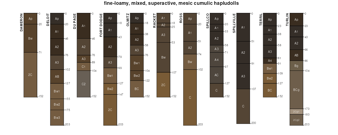
| Racket silt loam, 1 to 3 percent slopes, occasionally flooded | 76421 | 8063 | 2579881 | 2rt1h | mo015 | 1986 | 1:24000 |
Racket silt loam, 0 to 2 percent slopes, occasionally flooded | 75421 | 7598 | 2537502 | 2qq17 | mo015 | 1986 | 1:24000 |
Racket silt loam, 1 to 3 percent slopes, frequently flooded | 76377 | 2 | 2579880 | 2rt1g | mo015 | 1986 | 1:24000 |
Racket silt loam, 0 to 2 percent slopes, occasionally flooded | 75421 | 1418 | 2537504 | 2qq17 | mo029 | 1988 | 1:24000 |
Racket silt loam, 1 to 3 percent slopes, occasionally flooded | 76421 | 619 | 2673040 | 2rt1h | mo029 | 1988 | 1:24000 |
Racket silt loam, 0 to 2 percent slopes, frequently flooded | 75377 | 22 | 2536399 | 2qpzy | mo029 | 1988 | 1:24000 |
Racket silt loam, 1 to 3 percent slopes, frequently flooded | 76377 | 3310 | 2673046 | 2rt1g | mo039 | 2001 | 1:24000 |
Racket silt loam, 0 to 2 percent slopes, frequently flooded | 75377 | 557 | 2536392 | 2qpzy | mo039 | 2001 | 1:24000 |
Racket silt loam, clayey substratum, 1 to 3 percent slopes, frequently flooded | 67135 | 1819 | 2575507 | 2r0dk | mo051 | 2002 | 1:24000 |
Racket silt loam, clayey substratum, 0 to 3 percent slopes, frequently flooded | 75456 | 1536 | 2537527 | 2qq1f | mo051 | 2002 | 1:24000 |
Racket silt loam, 0 to 2 percent slopes, frequently flooded | 75377 | 14051 | 2536400 | 2qpzy | mo059 | 1988 | 1:24000 |
Racket silt loam, 1 to 3 percent slopes, frequently flooded | 76377 | 2684 | 2673064 | 2rt1g | mo059 | 1988 | 1:24000 |
Racket loam, 0 to 3 percent slopes, frequently flooded | 75406 | 423 | 2536601 | 2qq0v | mo067 | 2004 | 1:24000 |
Racket silt loam, 0 to 2 percent slopes, frequently flooded | 75377 | 149 | 2536398 | 2qpzy | mo077 | 1979 | 1:24000 |
Racket silt loam, 0 to 2 percent slopes, occasionally flooded | 75421 | 4938 | 2537503 | 2qq17 | mo085 | 1988 | 1:24000 |
Racket silt loam, 1 to 3 percent slopes, occasionally flooded | 76421 | 2137 | 2673085 | 2rt1h | mo085 | 1988 | 1:24000 |
Racket silt loam, 1 to 3 percent slopes, frequently flooded | 76377 | 406 | 2673084 | 2rt1g | mo085 | 1988 | 1:24000 |
Racket silt loam, 0 to 2 percent slopes, frequently flooded | 75377 | 135 | 2536393 | 2qpzy | mo085 | 1988 | 1:24000 |
Racket loam, 0 to 3 percent slopes, occasionally flooded | 75433 | 174 | 2537521 | 2qq1c | mo091 | 2004 | 1:24000 |
Racket loam, 0 to 3 percent slopes, frequently flooded | 75406 | 51 | 2536602 | 2qq0v | mo093 | 1988 | 1:24000 |
Racket loam, 1 to 3 percent slopes, frequently flooded | 76030 | 22 | 2503366 | 2phql | mo093 | 1988 | 1:24000 |
Racket silt loam, 0 to 2 percent slopes, frequently flooded | 75377 | 8263 | 2536401 | 2qpzy | mo105 | 1997 | 1:24000 |
Racket silt loam, 1 to 3 percent slopes, frequently flooded | 76377 | 809 | 2673111 | 2rt1g | mo105 | 1997 | 1:24000 |
Racket silt loam, 0 to 2 percent slopes, occasionally flooded | 75421 | 4765 | 2537505 | 2qq17 | mo131 | 2001 | 1:24000 |
Racket silt loam, 1 to 3 percent slopes, occasionally flooded | 76421 | 1728 | 2673134 | 2rt1h | mo131 | 2001 | 1:24000 |
Racket silt loam, 0 to 2 percent slopes, occasionally flooded | 75421 | 272 | 2537506 | 2qq17 | mo135 | 1962 | 1:24000 |
Racket silt loam, clayey substratum, 0 to 3 percent slopes, frequently flooded | 75456 | 22 | 2537526 | 2qq1f | mo135 | 1962 | 1:24000 |
Racket silt loam, 0 to 2 percent slopes, occasionally flooded | 75421 | 6102 | 2537507 | 2qq17 | mo141 | 1996 | 1:24000 |
Racket silt loam, 1 to 3 percent slopes, occasionally flooded | 76421 | 4716 | 2673138 | 2rt1h | mo141 | 1996 | 1:24000 |
Racket loam, 0 to 3 percent slopes, occasionally flooded | 75433 | 82 | 2537523 | 2qq1c | mo149 | 2004 | 1:24000 |
Racket loam, 0 to 3 percent slopes, frequently flooded | 75406 | 1073 | 2536603 | 2qq0v | mo153 | 2003 | 1:24000 |
Racket loam, 0 to 3 percent slopes, frequently flooded | 75406 | 5 | 2536604 | 2qq0v | mo157 | 1983 | 1:24000 |
Racket silt loam, 1 to 3 percent slopes, frequently flooded | 76377 | 6621 | 2673161 | 2rt1g | mo167 | 1993 | 1:24000 |
Racket silt loam, 0 to 2 percent slopes, frequently flooded | 75377 | 4262 | 2536394 | 2qpzy | mo167 | 1993 | 1:24000 |
Racket silt loam, 0 to 2 percent slopes, frequently flooded | 75377 | 27 | 2536390 | 2qpzy | mo169 | 1984 | 1:24000 |
Racket silt loam, 0 to 2 percent slopes, occasionally flooded | 75421 | 2 | 2537501 | 2qq17 | mo169 | 1984 | 1:24000 |
Racket silt loam, 1 to 3 percent slopes, frequently flooded | 76377 | 183 | 2579910 | 2rt1g | mo185 | 1984 | 1:24000 |
Racket loam, 0 to 3 percent slopes, frequently flooded | 75406 | 3144 | 2536606 | 2qq0v | mo186 | 1982 | 1:24000 |
Racket loam, 1 to 3 percent slopes, frequently flooded | 76030 | 52 | 2508767 | 2phql | mo186 | 1982 | 1:24000 |
Racket loam, 0 to 3 percent slopes, frequently flooded | 75406 | 14 | 2536605 | 2qq0v | mo187 | 1979 | 1:24000 |
Racket loam, 0 to 3 percent slopes, occasionally flooded | 75433 | 234 | 2537520 | 2qq1c | mo203 | 2004 | 1:24000 |
Racket loam, 1 to 3 percent slopes, frequently flooded | 76030 | 10 | 2503369 | 2phql | mo203 | 2004 | 1:24000 |
Racket loam, 0 to 3 percent slopes, occasionally flooded | 75433 | 472 | 2537522 | 2qq1c | mo213 | 1990 | 1:24000 |
Racket loam, 0 to 3 percent slopes, frequently flooded | 75406 | 1248 | 2536607 | 2qq0v | mo215 | 2002 | 1:24000 |
Racket loam, 0 to 3 percent slopes, frequently flooded | 75406 | 2744 | 2536600 | 2qq0v | mo221 | 2003 | 1:24000 |
Racket loam, 1 to 3 percent slopes, frequently flooded | 76030 | 160 | 2487768 | 2phql | mo221 | 2003 | 1:24000 |
Racket silt loam, 0 to 2 percent slopes, frequently flooded | 75377 | 515 | 2536396 | 2qpzy | mo225 | 1988 | 1:24000 |
Racket silt loam, 1 to 3 percent slopes, frequently flooded | 76377 | 363 | 2673204 | 2rt1g | mo225 | 1988 | 1:24000 |
Racket silt loam, 0 to 2 percent slopes, frequently flooded | 75377 | 45 | 2536397 | 2qpzy | mo229 | 1979 | 1:24000 |


