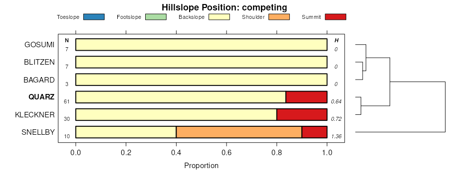
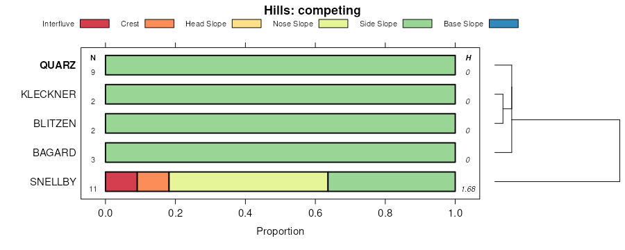
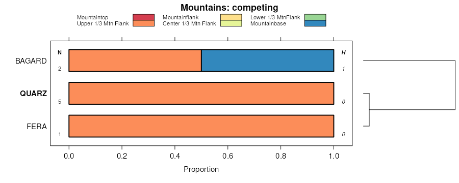
| Eboda-Quarz-Loncan association | 993 | 3547 | 2518891 | 2qj83 | nv612 | 1968 | 1:24000 |
Quarz-Cleavage-Loncan association | 1725 | 1338 | 2518903 | 2qj8j | nv612 | 1968 | 1:24000 |
Linkup-Quarz association | 1676 | 965 | 2517918 | 2qhm0 | nv612 | 1968 | 1:24000 |
Devoy association | DE | 2080 | 477925 | j19y | nv621 | 1971 | 1:24000 |
Quarz-McIvey-Cleavage association | 1724 | 59 | 2633987 | 2rhhc | nv621 | 1971 | 1:24000 |
Leevan-Quarz-McIvey association | 702 | 14 | 2633988 | 2rhhd | nv621 | 1971 | 1:24000 |
Chen-Quarz-Arcia association | 1874 | 15990 | 477140 | j0hm | nv763 | 1986 | 1:24000 |
Graley-Quarz-Ninemile association | 1732 | 14955 | 477114 | j0gs | nv763 | 1986 | 1:24000 |
Chen-Graley-Quarz association | 1870 | 13510 | 477137 | 2t6wh | nv763 | 1986 | 1:24000 |
Alyan, moderately steep-Alyan-Quarz association | 2002 | 11912 | 477162 | j0jb | nv763 | 1986 | 1:24000 |
Cavanaugh-Quarz-Alyan association | 221 | 9050 | 477173 | j0jp | nv763 | 1986 | 1:24000 |
Ratsow-Quarz-Susie Creek association | 3100 | 6040 | 477244 | j0lz | nv763 | 1986 | 1:24000 |
Linkup-Quarz-Alyan association | 1673 | 3520 | 477096 | j0g6 | nv763 | 1986 | 1:24000 |
Quarz-Cleavage-Hackwood association | 1740 | 3372 | 477116 | 2qhlq | nv763 | 1986 | 1:24000 |
Quarz-Alyan-Ninemile association | 1720 | 3320 | 477110 | j0gn | nv763 | 1986 | 1:24000 |
Quarz-Cleavage-Loncan association | 1725 | 3185 | 477111 | j0gp | nv763 | 1986 | 1:24000 |
Lerrow-Quarz-Rugar association | 1921 | 2780 | 477153 | j0j1 | nv763 | 1986 | 1:24000 |
Cotant-Quarz-Ninemile association | 1700 | 2775 | 477104 | j0gg | nv763 | 1986 | 1:24000 |
Deseed-Quarz association | 2173 | 2360 | 477169 | j0jk | nv763 | 1986 | 1:24000 |
Linkup-Quarz association | 1676 | 1530 | 477098 | j0g8 | nv763 | 1986 | 1:24000 |
Quarz-Ninemile-Pequop association | 1726 | 1465 | 477112 | j0gq | nv763 | 1986 | 1:24000 |
Quarz-Cleavage-Hackwood association | 1740 | 14096 | 2517909 | 2qhlq | nv764 | 2021 | 1:24000 |
Chen-McIvey-Tweener association | 219 | 11459 | 2517702 | 2q90m | nv764 | 2021 | 1:24000 |
Cotant-McIvey-Quarz association | 1821 | 6596 | 474603 | hxvs | nv764 | 2021 | 1:24000 |
Quarz-Quarz, very steep-Arcia association | 1723 | 1116 | 2517700 | 2q90k | nv764 | 2021 | 1:24000 |
Shalcleav-Quarz association | 232 | 38583 | 474957 | hy76 | nv765 | 1986 | 1:24000 |
Quarz-Shalper-Shalcleav association | 280 | 4375 | 474970 | hy7m | nv765 | 1986 | 1:24000 |
McIvey-Quarz association | 040 | 3700 | 474851 | hy3s | nv765 | 1986 | 1:24000 |
Quarz-Cotant association | 281 | 2450 | 474971 | hy7n | nv765 | 1986 | 1:24000 |
Rodie-Quarz-Shalcleav association | 422 | 1675 | 475032 | hy9m | nv765 | 1986 | 1:24000 |
Quarz, steep-Quarz-Arcia association | 282 | 1150 | 474972 | hy7p | nv765 | 1986 | 1:24000 |
Quarz-Cleavage-Loncan association | 1725 | 48601 | 478772 | j268 | nv767 | 1986 | 1:24000 |
Cotant-McIvey-Quarz association | 1821 | 36651 | 478782 | j26l | nv767 | 1986 | 1:24000 |
McIvey-Quarz-Rock outcrop association | 213 | 13497 | 478830 | j284 | nv767 | 1986 | 1:24000 |
Ninemile-Quarz-Rock outcrop association | 840 | 10351 | 479012 | j2g0 | nv767 | 1986 | 1:24000 |
Susie Creek-Kleckner-Quarz association | 1662 | 9195 | 478763 | j25z | nv767 | 1986 | 1:24000 |
Chen-Cleavage-Quarz association | 1886 | 7067 | 478805 | j27b | nv767 | 1986 | 1:24000 |
Quarz-Tusel-Cleavage association | 1729 | 6937 | 478775 | j26c | nv767 | 1986 | 1:24000 |
Donna-Stampede-Quarz association | 448 | 5583 | 478913 | j2bt | nv767 | 1986 | 1:24000 |
Chen-Quarz-Linkup association | 1885 | 4793 | 478804 | j279 | nv767 | 1986 | 1:24000 |
Quarz-Susie Creek-Loncan association | 1727 | 4759 | 478773 | j269 | nv767 | 1986 | 1:24000 |
Bullump-Quarz-Gando association | 925 | 4743 | 479021 | j2g9 | nv767 | 1986 | 1:24000 |
Quarz-Cleavage-Tusel association | 1728 | 4478 | 478774 | j26b | nv767 | 1986 | 1:24000 |
Leevan-Quarz-McIvey association | 702 | 4333 | 478985 | j2f4 | nv767 | 1986 | 1:24000 |
Quarz-McIvey-Cleavage association | 1724 | 4093 | 478771 | j267 | nv767 | 1986 | 1:24000 |
Akler-Quarz-Soughe association | 306 | 3664 | 478878 | j29p | nv767 | 1986 | 1:24000 |
Eboda-Quarz-Loncan association | 993 | 3462 | 479029 | j2gk | nv767 | 1986 | 1:24000 |
Quarz-Quarz, sloping-Arcia association | 1721 | 3019 | 478769 | j265 | nv767 | 1986 | 1:24000 |
Quarz-Pernty, moderately steep-Pernty association | 1722 | 2732 | 478770 | j266 | nv767 | 1986 | 1:24000 |
Yuko-Tuffo-Quarz association | 760 | 2453 | 478994 | j2ff | nv767 | 1986 | 1:24000 |
Quarz-Quarz, very steep-Arcia association | 1723 | 1909 | 3270900 | 2q90k | nv767 | 1986 | 1:24000 |
Chen-Graley-Quarz association | 1888 | 1730 | 478807 | 2t6wh | nv767 | 1986 | 1:24000 |
Linkup-Quarz association | 1676 | 611 | 2633969 | 2rhgr | nv767 | 1986 | 1:24000 |
Bregar-Roca-Quarz association | 3432 | 5065 | 479630 | j32y | nv775 | 1985 | 1:24000 |
Quarz-Linrose-Slaven association | 814 | 4655 | 479722 | j35x | nv775 | 1985 | 1:24000 |
Quarz-Linrose-Cleavage association | 816 | 2080 | 479723 | j35y | nv775 | 1985 | 1:24000 |
Quarz-Chen-Duff association | 813 | 10254 | 479891 | j3cc | nv776 | 1983 | 1:63360 |
Quarz-Highams-Atrypa variant association | 811 | 6182 | 479889 | j3c9 | nv776 | 1983 | 1:63360 |
Quarz-Bregar-Duff association | 812 | 6095 | 479890 | j3cb | nv776 | 1983 | 1:63360 |
Whitepeak-Quarz-Softscrabble association | 891 | 6069 | 479905 | j3ct | nv776 | 1983 | 1:63360 |
Freznik-Quarz-Jivas association | 801 | 4037 | 479887 | j3c7 | nv776 | 1983 | 1:63360 |
Quarz-Duff association | 814 | 1871 | 479892 | j3cd | nv776 | 1983 | 1:63360 |
Bregar variant-Hymas-Quarz association | 975 | 1086 | 479915 | j3d4 | nv776 | 1983 | 1:63360 |