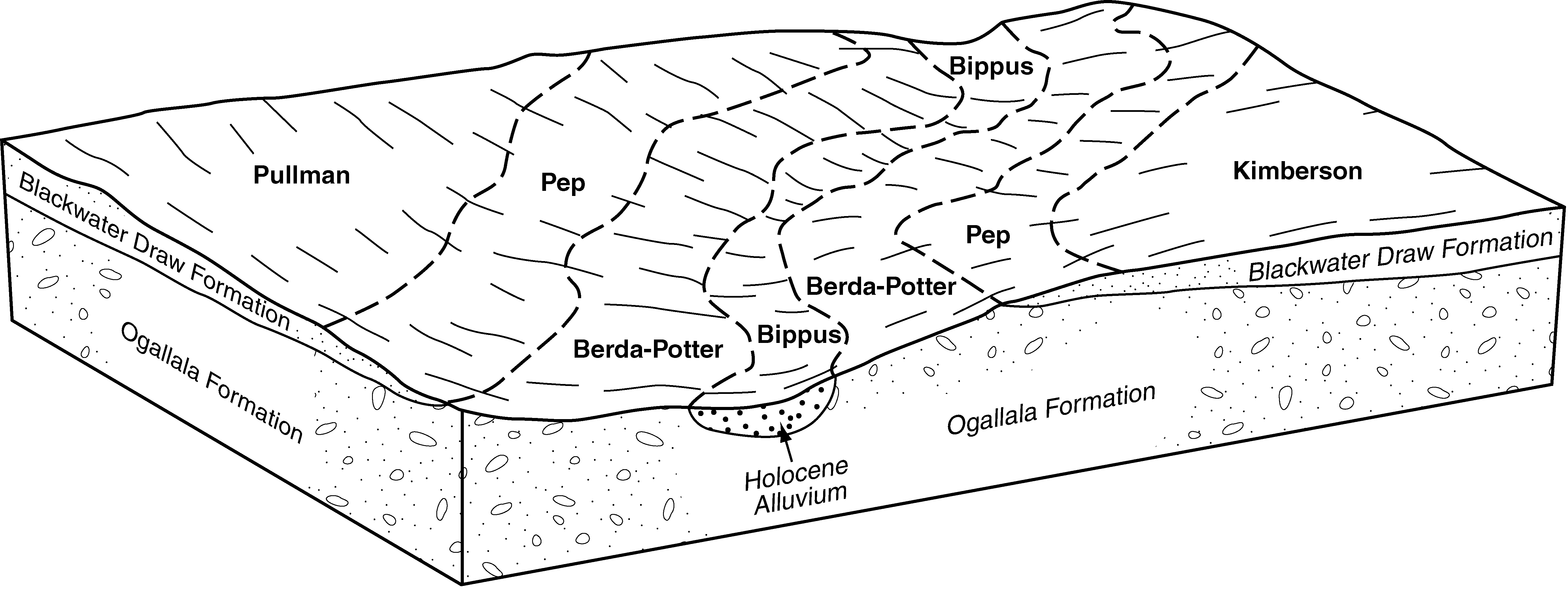
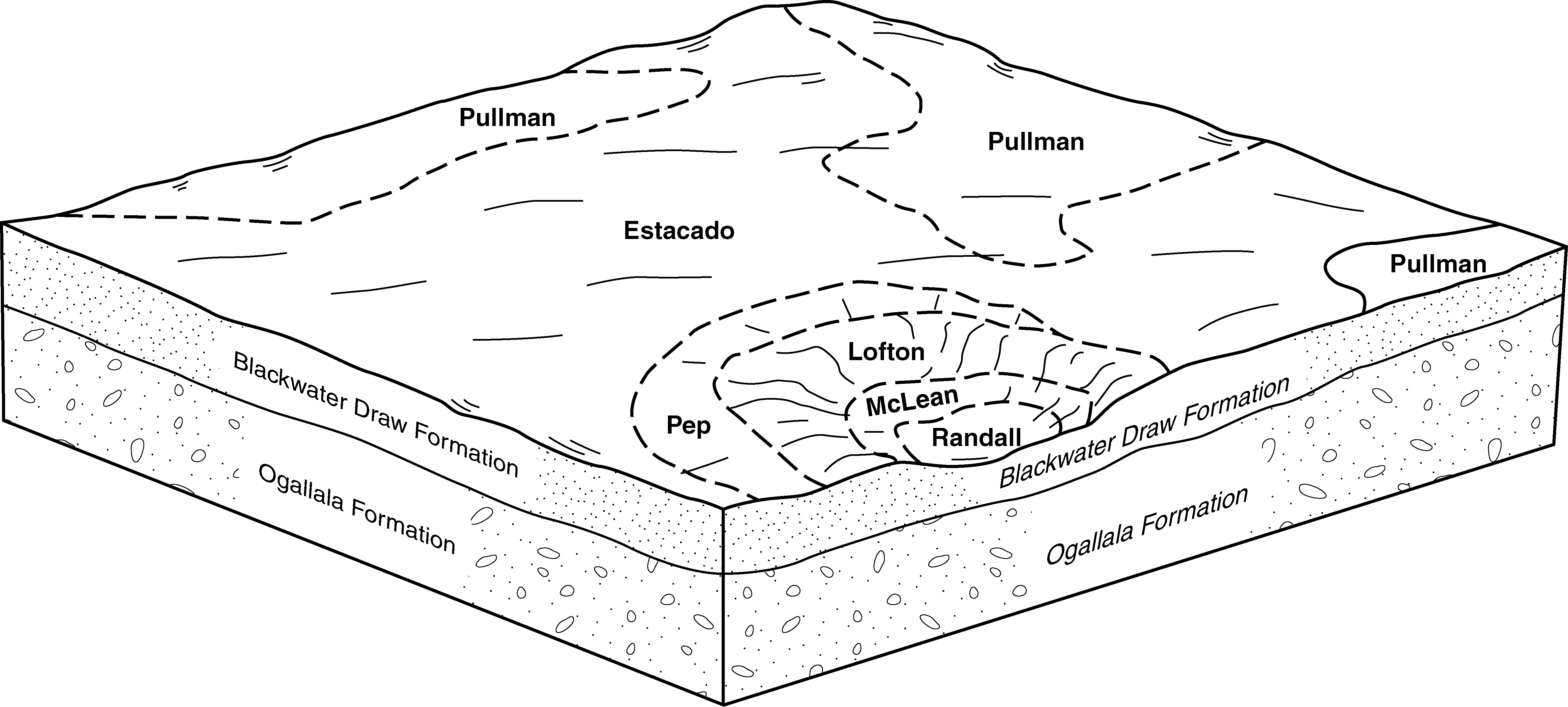
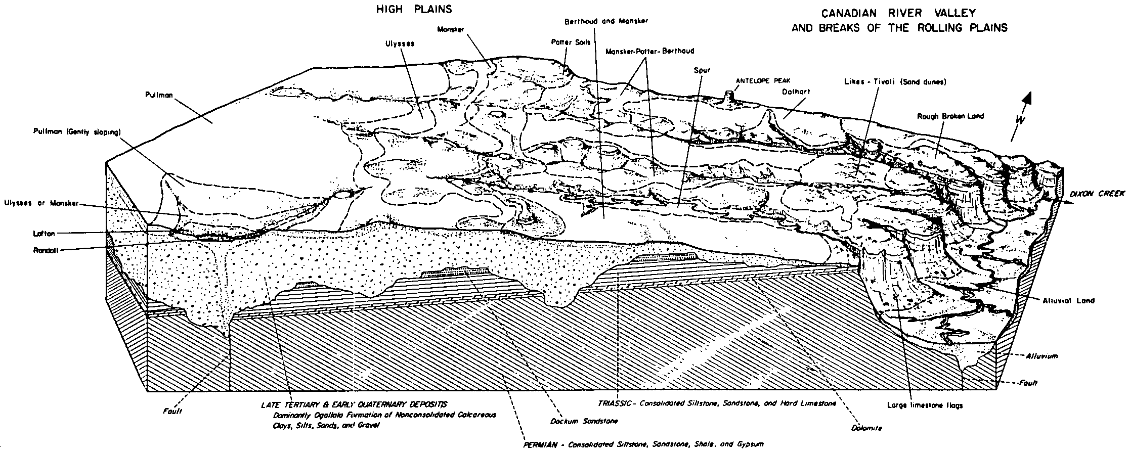
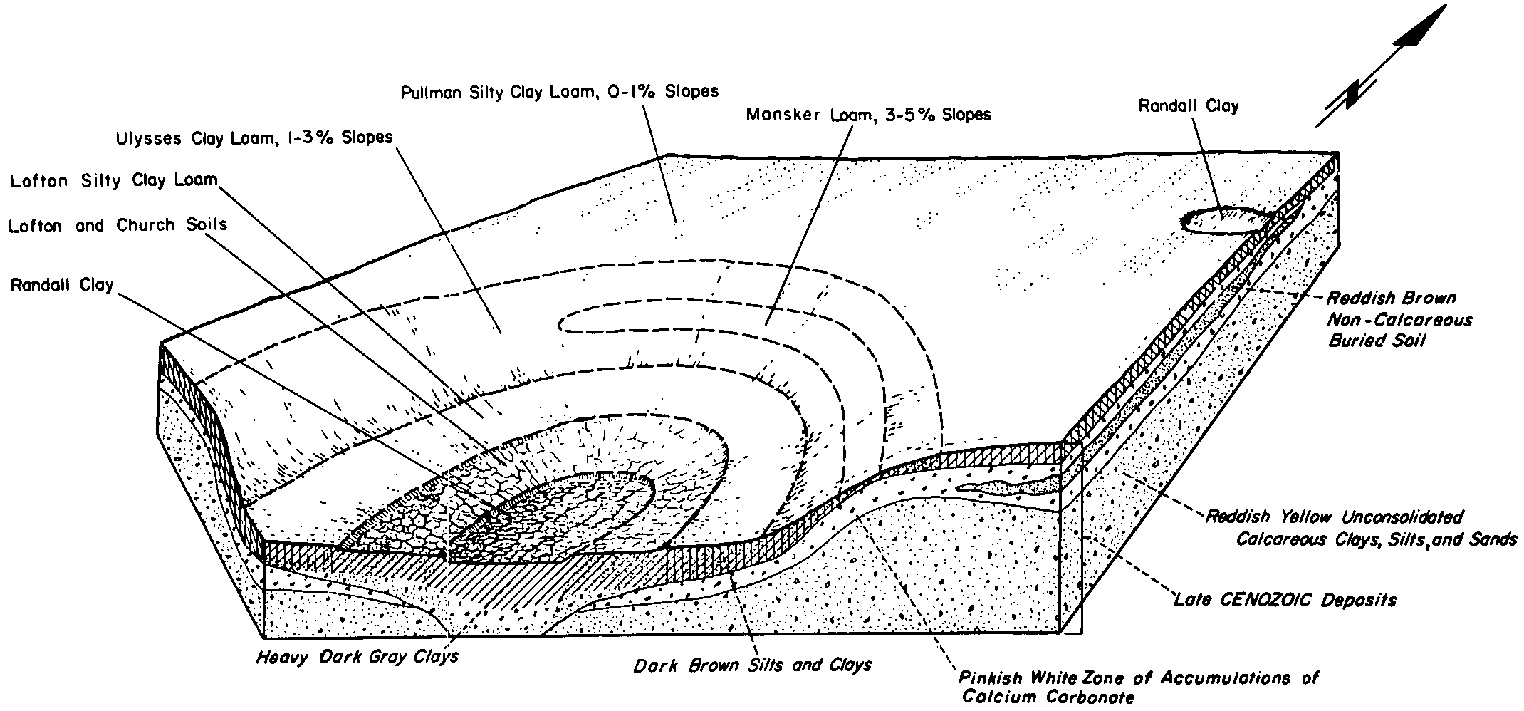
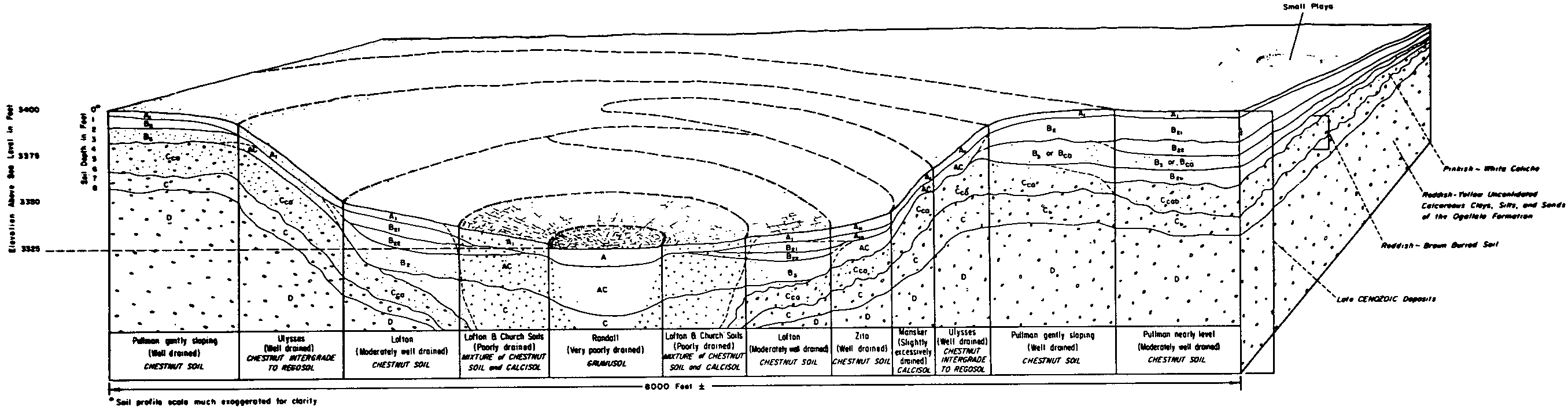
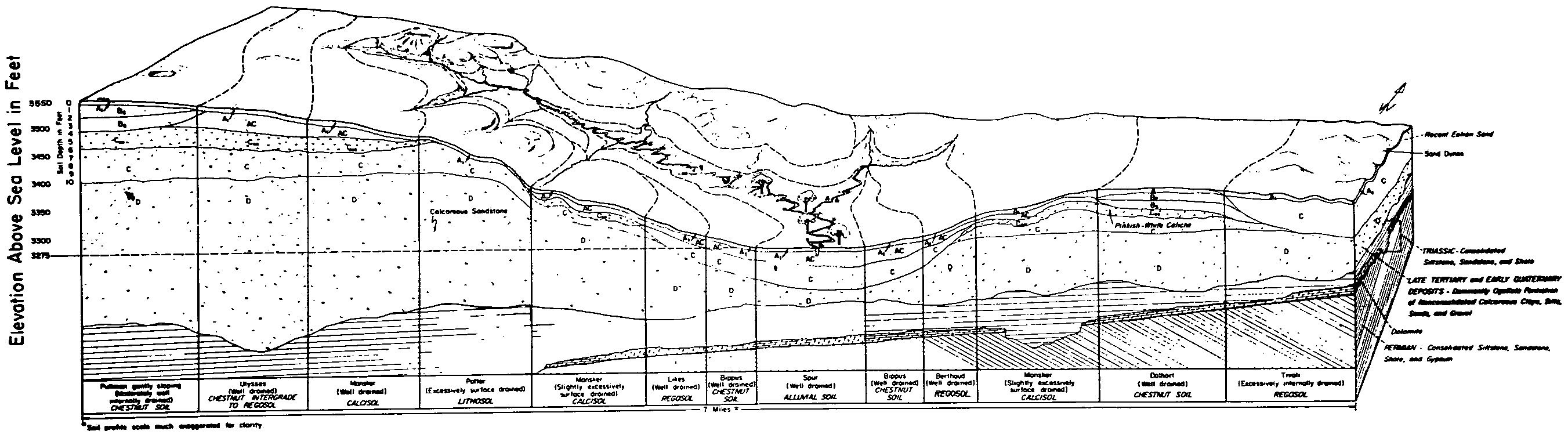
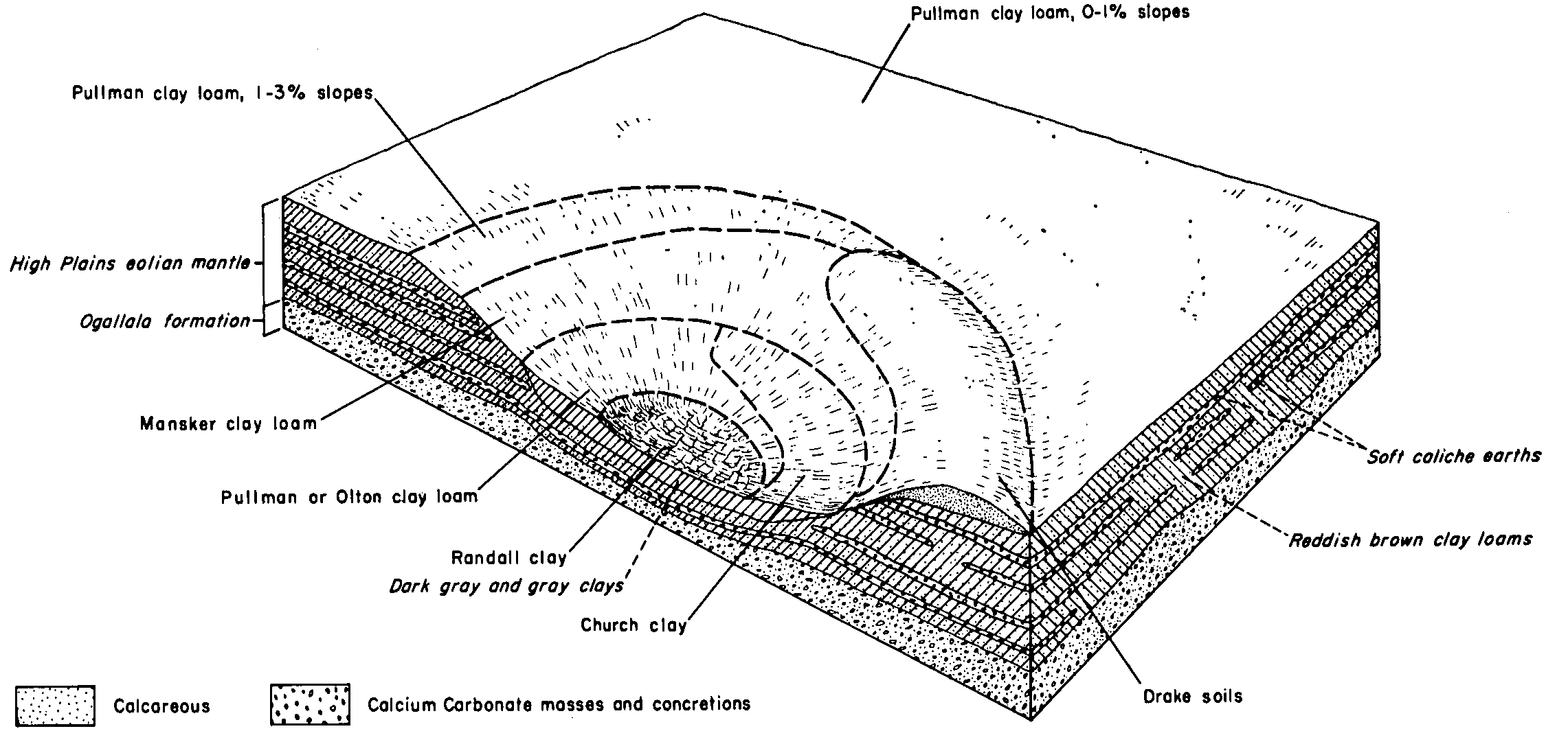
| Pullman silty clay loam, 0 to 1 percent slopes | PuA | 170992 | 362488 | 2tw3s | tx011 | 1963 | 1:20000 |
Pullman silty clay loam, 1 to 3 percent slopes | PuB | 37714 | 362489 | 2tw3t | tx011 | 1963 | 1:20000 |
Pullman silty clay loam, 1 to 3 percent slopes, moderately eroded | PuB2 | 1169 | 362490 | 308qg | tx011 | 1963 | 1:20000 |
Pullman clay loam, 0 to 1 percent slopes | PuA | 157178 | 363293 | f5ry | tx045 | 1972 | 1:20000 |
Pullman clay loam, 1 to 3 percent slopes | PuB | 11592 | 363294 | f5rz | tx045 | 1972 | 1:20000 |
Pullman clay loam, 0 to 1 percent slopes | PuA | 87031 | 377967 | f5ry | tx065 | 2000 | 1:24000 |
Pullman clay loam, 1 to 3 percent slopes | PuB | 55019 | 377968 | f5rz | tx065 | 2000 | 1:24000 |
Pullman clay loam, 0 to 1 percent slopes | PuA | 237283 | 363776 | f5ry | tx069 | 1969 | 1:20000 |
Pullman clay loam, 1 to 3 percent slopes | PuB | 24336 | 363777 | f5rz | tx069 | 1969 | 1:20000 |
Pullman silty clay loam, 0 to 1 percent slopes | PuA | 130943 | 364735 | 2tw3s | tx107 | 1964 | 1:20000 |
Pullman silty clay loam, 1 to 3 percent slopes | PuB | 8545 | 364736 | 2tw3t | tx107 | 1964 | 1:20000 |
Pullman clay loam, 0 to 1 percent slopes | PuA | 423536 | 378064 | f5ry | tx117 | 1999 | 1:24000 |
Pullman clay loam, 1 to 3 percent slopes | PuB | 49747 | 378065 | f5rz | tx117 | 1999 | 1:24000 |
Pullman clay loam, 0 to 1 percent slopes | PuA | 26859 | 365141 | f5ry | tx125 | 1965 | 1:20000 |
Pullman clay loam, 1 to 3 percent slopes | PuB | 1840 | 365142 | f5rz | tx125 | 1965 | 1:20000 |
Pullman clay loam, 0 to 1 percent slopes | PuA | 12056 | 365199 | f5ry | tx129 | 1975 | 1:24000 |
Pullman clay loam, 1 to 3 percent slopes | PuB | 884 | 365200 | f5rz | tx129 | 1975 | 1:24000 |
Pullman clay loam, 0 to 1 percent slopes | PuA | 413127 | 695972 | f5ry | tx153 | 2004 | 1:24000 |
Pullman clay loam, 1 to 3 percent slopes | PuB | 19748 | 695973 | f5rz | tx153 | 2004 | 1:24000 |
Pullman clay loam, 0 to 1 percent slopes | PuA | 148086 | 391946 | f5ry | tx179 | 1965 | 1:20000 |
Pullman clay loam, 1 to 3 percent slopes | PuB | 19510 | 391947 | f5rz | tx179 | 1965 | 1:20000 |
Pullman clay loam, 0 to 1 percent slopes | PuA | 352766 | 366915 | f5ry | tx189 | 1969 | 1:20000 |
Pullman clay loam, 1 to 3 percent slopes | PuB | 10426 | 366916 | f5rz | tx189 | 1969 | 1:20000 |
Pullman clay loam, 0 to 1 percent slopes | PmA | 604 | 367577 | f5ry | tx211 | 1967 | 1:20000 |
Pullman clay loam, 0 to 1 percent slopes | PuA | 52426 | 369863 | f5ry | tx303 | 1975 | 1:20000 |
Pullman clay loam, 0 to 1 percent slopes | PuA | 4468 | 370891 | f5ry | tx345 | 1972 | 1:24000 |
Pullman clay loam, 0 to 1 percent slopes | PuA | 57157 | 3124162 | f5ry | tx359 | 1978 | 1:24000 |
Pullman clay loam, 1 to 3 percent slopes | PuB | 13342 | 3124163 | f5rz | tx359 | 1978 | 1:24000 |
Pullman clay loam, breaks, 1 to 3 percent slopes | PtB | 123 | 3124188 | 2yk83 | tx359 | 1978 | 1:24000 |
Pullman clay loam, breaks, 0 to 1 percent slopes | PtA | 86 | 3124187 | 2yk82 | tx359 | 1978 | 1:24000 |
Pullman clay loam, 0 to 1 percent slopes | PuA | 54843 | 2599123 | f5ry | tx369 | 1973 | 1:24000 |
Pullman clay loam, 1 to 3 percent slopes | PuB | 2487 | 2599124 | f5rz | tx369 | 1973 | 1:24000 |
Pullman clay loam, 0 to 1 percent slopes | PuA | 34676 | 3124233 | f5ry | tx375 | 1974 | 1:24000 |
Pullman clay loam, 1 to 3 percent slopes | PuB | 9346 | 3124234 | f5rz | tx375 | 1974 | 1:24000 |
Pullman-Urban land complex | PuU | 7945 | 3124264 | 2mhvq | tx375 | 1974 | 1:24000 |
Pullman clay loam, breaks, 1 to 3 percent slopes | PtB | 1457 | 3124279 | 2yk83 | tx375 | 1974 | 1:24000 |
Pullman clay loam, breaks, 0 to 1 percent slopes | PtA | 170 | 3124278 | 2yk82 | tx375 | 1974 | 1:24000 |
Pullman clay loam, 0 to 1 percent slopes | PuA | 182790 | 371407 | f5ry | tx381 | 1999 | 1:24000 |
Pullman clay loam, 1 to 3 percent slopes | PuB | 59704 | 371408 | f5rz | tx381 | 1999 | 1:24000 |
Pullman-Urban land complex | PuU | 6230 | 643367 | plgs | tx381 | 1999 | 1:24000 |
Pullman clay loam, 0 to 1 percent slopes | PuA | 22137 | 371533 | f5ry | tx393 | 1979 | 1:24000 |
Pullman clay loam, 1 to 3 percent slopes | PuB | 1819 | 371534 | f5rz | tx393 | 1979 | 1:24000 |
Pullman clay loam, 0 to 1 percent slopes | PuA | 379443 | 372344 | f5ry | tx437 | 1970 | 1:20000 |
Pullman clay loam, 1 to 3 percent slopes | PuB | 34639 | 372345 | f5rz | tx437 | 1970 | 1:20000 |
Pullman silty clay loam, 0 to 1 percent slopes | PuA | 342 | 373324 | djgq | tx483 | 1970 | 1:24000 |


