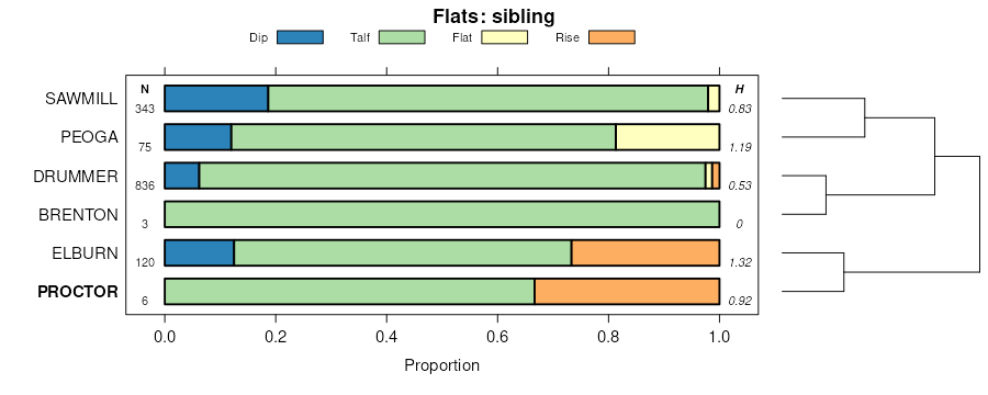
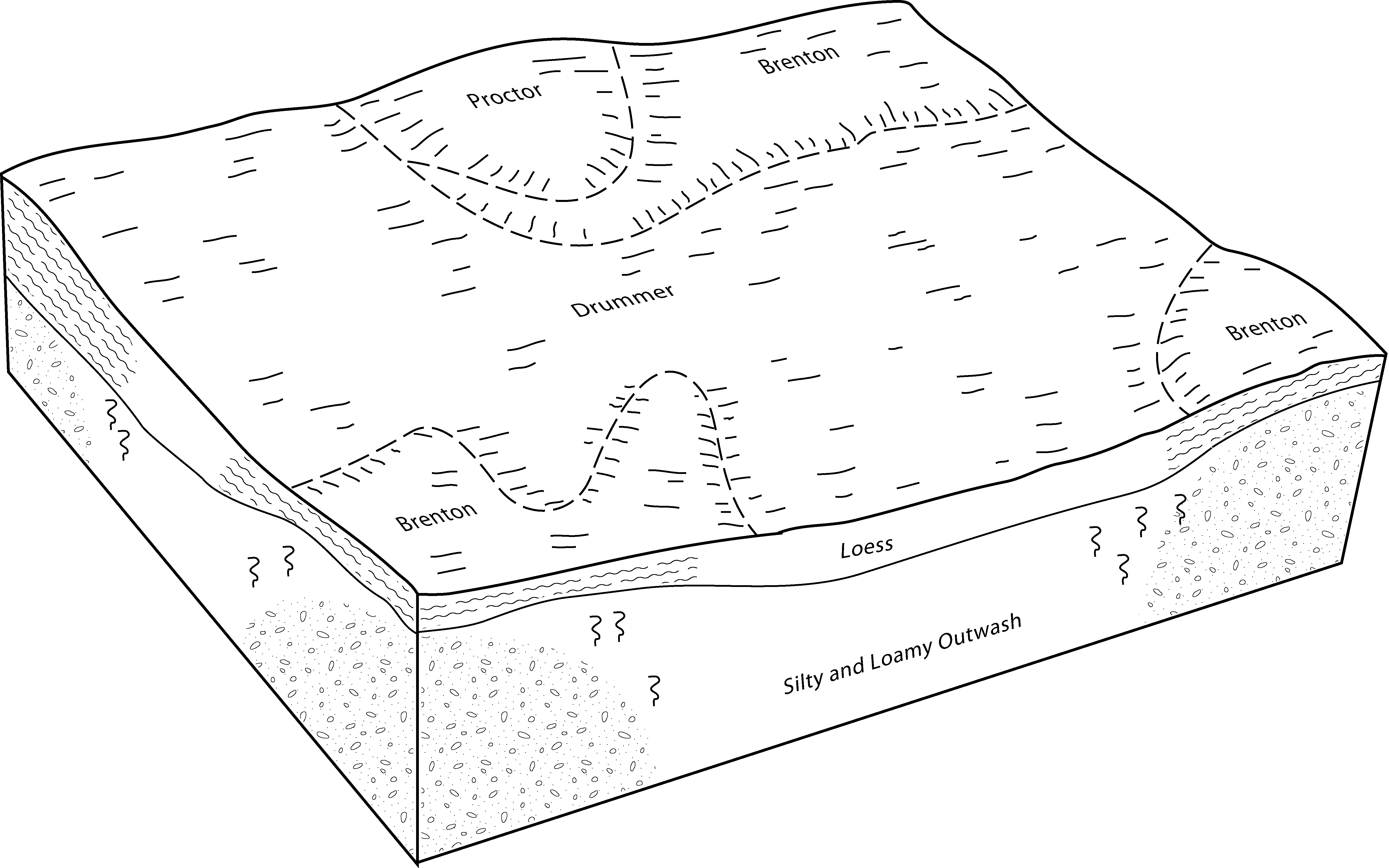
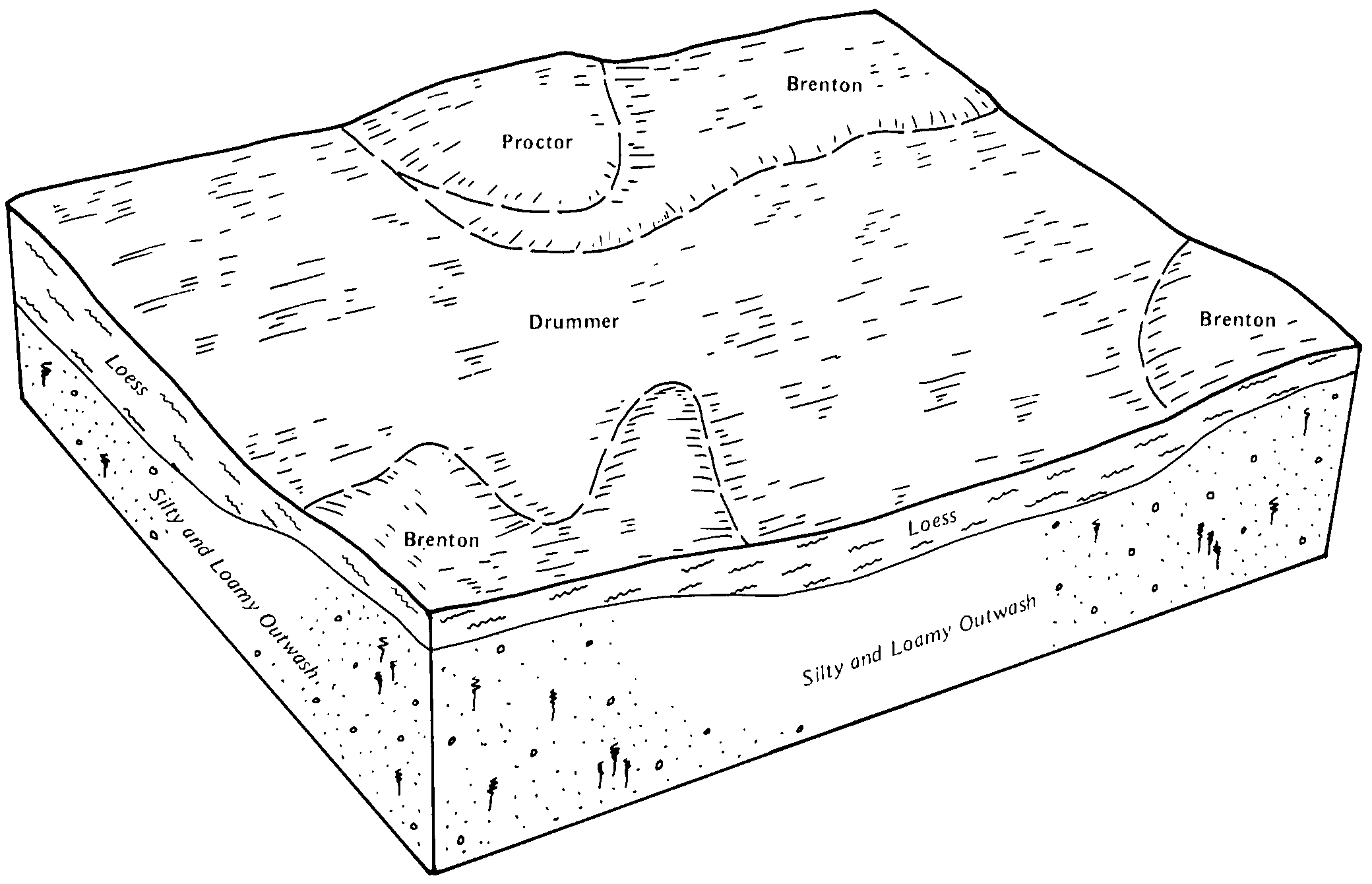
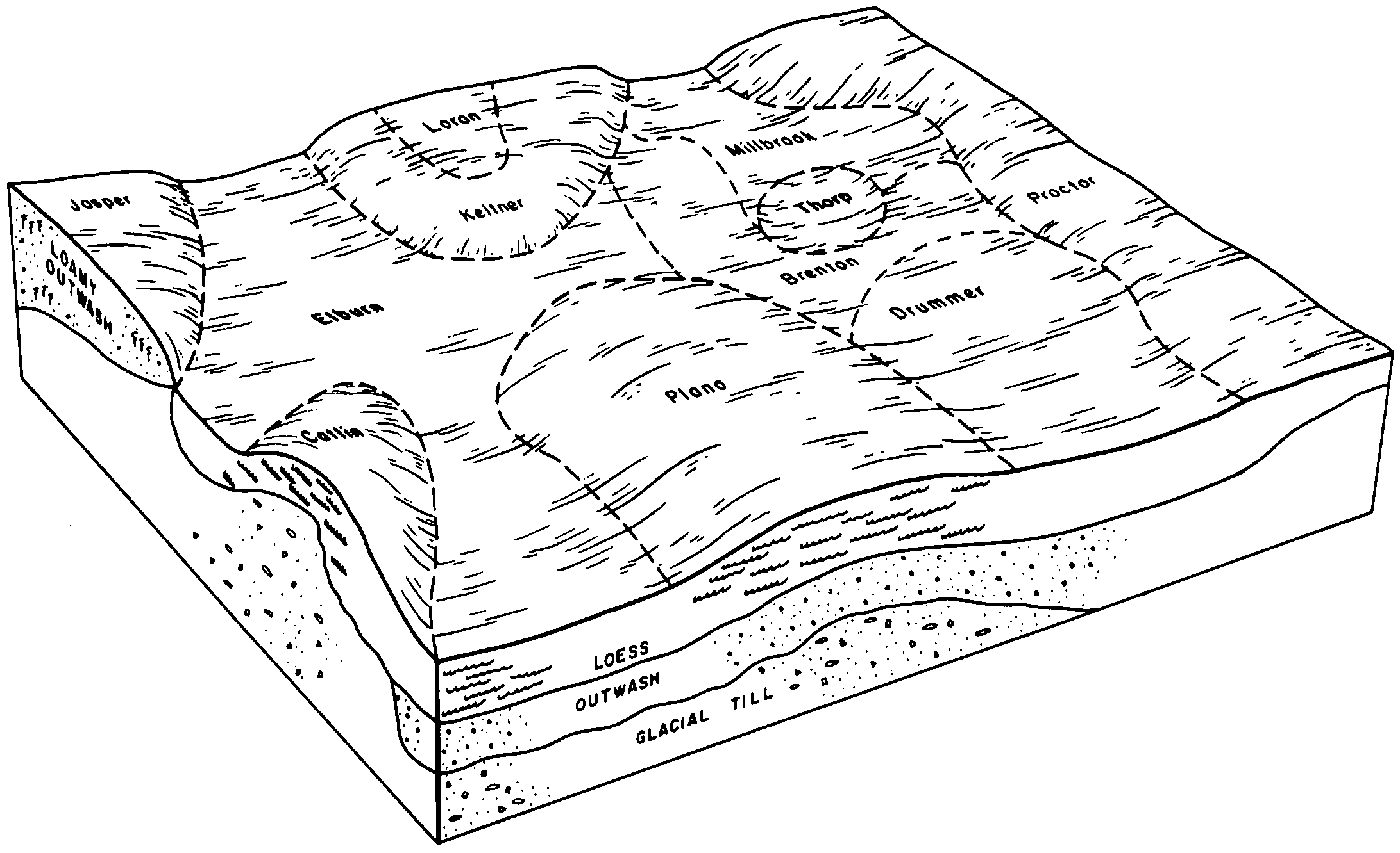
| Proctor silt loam, 2 to 5 percent slopes | 148B | 165 | 1483391 | 2sss5 | il007 | 2006 | 1:12000 |
Proctor silt loam, 0 to 2 percent slopes | 148A | 9 | 1483390 | 2sss4 | il007 | 2006 | 1:12000 |
Proctor silt loam, 2 to 5 percent slopes, eroded | 148B2 | 14 | 242977 | 2sss6 | il019 | 1999 | 1:12000 |
Proctor silt loam, 0 to 2 percent slopes, rarely flooded | 7148A | 511 | 261782 | 8sdl | il021 | 1999 | 1:12000 |
Proctor silt loam, 2 to 5 percent slopes | 148B | 195 | 1428389 | 2sss5 | il029 | 2005 | 1:12000 |
Proctor silt loam, 0 to 2 percent slopes | 148A | 322 | 183897 | 2sss4 | il037 | 1998 | 1:12000 |
Proctor silt loam, 2 to 5 percent slopes | 148B | 54 | 207280 | 2sss5 | il037 | 1998 | 1:12000 |
Proctor silt loam, 2 to 5 percent slopes, eroded | 148B2 | 260 | 1592506 | 2sss6 | il039 | 2005 | 1:12000 |
Proctor silt loam, 2 to 5 percent slopes, rarely flooded | 7148B | 28 | 1598268 | 1qn41 | il039 | 2005 | 1:12000 |
Proctor silt loam, 2 to 5 percent slopes | 148B | 2 | 1529224 | 2sss5 | il041 | 2004 | 1:12000 |
Proctor silt loam, 2 to 5 percent slopes | 148B | 2740 | 843545 | 2sss5 | il045 | 1997 | 1:12000 |
Proctor silt loam, 0 to 2 percent slopes | 148A | 235 | 843544 | 2sss4 | il045 | 1997 | 1:12000 |
Proctor silt loam, 2 to 5 percent slopes | 148B | 2610 | 198306 | 2sss5 | il053 | 2001 | 1:12000 |
Proctor silt loam, 2 to 5 percent slopes, eroded | 148B2 | 21 | 198307 | 2sss6 | il053 | 2001 | 1:12000 |
Proctor silt loam, 0 to 2 percent slopes, rarely flooded | 7148A | 236 | 211723 | 739s | il061 | 1968 | 1:15840 |
Proctor silt loam, 2 to 5 percent slopes | 148B | 3126 | 868708 | 2sss5 | il063 | 2005 | 1:12000 |
Proctor silt loam, 0 to 2 percent slopes | 148A | 845 | 868707 | 2sss4 | il063 | 2005 | 1:12000 |
Proctor silt loam, 0 to 2 percent slopes | 148A | 385 | 262986 | 8tnf | il071 | 2005 | 1:12000 |
Proctor silt loam, 2 to 5 percent slopes | 148B | 162 | 262987 | 8tng | il071 | 2005 | 1:12000 |
Proctor silt loam, 2 to 5 percent slopes | 148B | 4673 | 244656 | 2sss5 | il073 | 2001 | 1:12000 |
Proctor silt loam, 5 to 10 percent slopes, eroded | 148C2 | 2472 | 244657 | 2sss7 | il073 | 2001 | 1:12000 |
Proctor silt loam, 2 to 5 percent slopes | 148B | 24 | 198803 | 2sss5 | il089 | 2000 | 1:12000 |
Proctor silt loam, 0 to 2 percent slopes | 148A | 1708 | 638741 | 2sss4 | il093 | 2007 | 1:12000 |
Proctor silt loam, 2 to 5 percent slopes | 148B | 1508 | 638742 | 2sss5 | il093 | 2007 | 1:12000 |
Proctor silt loam, 5 to 10 percent slopes, eroded | 148C2 | 660 | 638743 | 2sss7 | il093 | 2007 | 1:12000 |
Proctor silt loam, 2 to 5 percent slopes | 148B | 4620 | 1385707 | 2sss5 | il099 | 2006 | 1:12000 |
Proctor silt loam, 5 to 10 percent slopes, eroded | 148C2 | 2549 | 1385709 | 2sss7 | il099 | 2006 | 1:12000 |
Proctor silt loam, 0 to 2 percent slopes | 148A | 1331 | 1426128 | 2sss4 | il099 | 2006 | 1:12000 |
Proctor silt loam, 0 to 2 percent slopes | 148A | 785 | 176657 | 5xtm | il101 | 1952 | 1:42240 |
Proctor silt loam, 2 to 5 percent slopes | 148B | 410 | 176928 | 2sss5 | il105 | 1991 | 1:15840 |
Proctor silt loam, 5 to 10 percent slopes, eroded | 148C2 | 1259 | 1596000 | 2sss7 | il107 | 2006 | 1:12000 |
Proctor silt loam, 2 to 5 percent slopes | 148B | 646 | 1595993 | 2sss5 | il107 | 2006 | 1:12000 |
Proctor silt loam, sandy substratum, 0 to 2 percent slopes | 374A | 438 | 1595820 | 1qkl2 | il107 | 2006 | 1:12000 |
Proctor silt loam, 0 to 2 percent slopes, rarely flooded | 7148A | 351 | 1595821 | 1qkl3 | il107 | 2006 | 1:12000 |
Proctor silt loam, 10 to 18 percent slopes, eroded | 148D2 | 180 | 1596001 | 2sssn | il107 | 2006 | 1:12000 |
Proctor silt loam, 0 to 2 percent slopes | 148A | 3034 | 182412 | 2sss4 | il111 | 1997 | 1:12000 |
Proctor silt loam, 2 to 5 percent slopes | 148B | 2075 | 182414 | 2sss5 | il111 | 1997 | 1:12000 |
Proctor silt loam, 2 to 5 percent slopes, eroded | 148B2 | 4835 | 199075 | 2sss6 | il113 | 2000 | 1:12000 |
Proctor silt loam, 5 to 10 percent slopes, eroded | 148C2 | 639 | 199076 | 2sss7 | il113 | 2000 | 1:12000 |
Proctor silt loam, 2 to 5 percent slopes | 148B | 816 | 1913935 | 2sss5 | il115 | 2007 | 1:12000 |
Proctor silt loam, 5 to 10 percent slopes, eroded | 148C2 | 486 | 1913936 | 2sss7 | il115 | 2007 | 1:12000 |
Proctor silt loam, 2 to 5 percent slopes | 148B | 215 | 182080 | 2sss5 | il123 | 1997 | 1:15840 |
Proctor silt loam, sandy substratum, 0 to 2 percent slopes | 374A | 656 | 177795 | 5z0b | il125 | 1989 | 1:15840 |
Proctor silt loam, 0 to 2 percent slopes, rarely flooded | 7148A | 198 | 1406320 | 1j6d5 | il129 | 2005 | 1:12000 |
Proctor silt loam, 2 to 5 percent slopes | 148B | 1958 | 208960 | 2sss5 | il143 | 1986 | 1:15840 |
Proctor silt loam, 5 to 10 percent slopes, eroded | 148C2 | 388 | 208961 | 2sss7 | il143 | 1986 | 1:15840 |
Proctor silt loam, 2 to 5 percent slopes, eroded | 148B2 | 1484 | 1914023 | 2sss6 | il147 | 2009 | 1:12000 |
Proctor silty clay loam, 5 to 10 percent slopes, severely eroded | 148C3 | 319 | 1949703 | 2sssm | il147 | 2009 | 1:12000 |
Proctor silt loam, 5 to 10 percent slopes, eroded | 148C2 | 278 | 1914024 | 2sss7 | il147 | 2009 | 1:12000 |
Proctor silt loam, 0 to 2 percent slopes, rarely flooded | 7148A | 3163 | 199375 | 6pgg | il167 | 1999 | 1:12000 |
Proctor silt loam, 2 to 5 percent slopes | 148B | 1465 | 178994 | 2sss5 | il173 | 1990 | 1:15840 |
Proctor silt loam, 0 to 2 percent slopes | 148A | 559 | 178993 | 2sss4 | il173 | 1990 | 1:15840 |
Proctor silt loam, 5 to 10 percent slopes, eroded | 148C2 | 618 | 179061 | 2sss7 | il175 | 1992 | 1:15840 |
Proctor silt loam, 2 to 5 percent slopes | 148B | 506 | 179060 | 2sss5 | il175 | 1992 | 1:15840 |
Proctor silt loam, 2 to 5 percent slopes, rarely flooded | 7148B | 69 | 2542385 | 2r1z9 | il175 | 1992 | 1:15840 |
Proctor silt loam, 5 to 10 percent slopes, eroded | 148C2 | 1973 | 1591972 | 2sss7 | il177 | 2006 | 1:12000 |
Proctor silt loam, 2 to 5 percent slopes | 148B | 1034 | 1591971 | 2sss5 | il177 | 2006 | 1:12000 |
Proctor silt loam, 0 to 2 percent slopes | 148A | 305 | 179146 | 2sss4 | il177 | 2006 | 1:12000 |
Proctor silt loam, 0 to 2 percent slopes, rarely flooded | 7148A | 379 | 2509785 | 2qgxg | il179 | 1991 | 1:15840 |
Proctor silt loam, 0 to 2 percent slopes | 148A | 176 | 179358 | 2sss4 | il179 | 1991 | 1:15840 |
Proctor silt loam, 2 to 5 percent slopes | 148B | 2389 | 1601029 | 2sss5 | il183 | 2006 | 1:12000 |
Proctor silt loam, 0 to 2 percent slopes | 148A | 941 | 1601028 | 2sss4 | il183 | 2006 | 1:12000 |
Proctor silt loam, 5 to 10 percent slopes, eroded | 148C2 | 259 | 1601126 | 2sss7 | il183 | 2006 | 1:12000 |
Proctor silt loam, 2 to 5 percent slopes | 148B | 269 | 869170 | 2sss5 | il203 | 2008 | 1:12000 |
Proctor silt loam, 0 to 3 percent slopes | PtA | 262 | 162351 | 5fy4 | in023 | 1978 | 1:20000 |
Proctor silt loam, 0 to 2 percent slopes | PsA | 958 | 164499 | 5j5f | in083 | 1979 | 1:15840 |
Proctor silt loam, 2 to 6 percent slopes | PrB | 1335 | 163053 | 5gns | in107 | 1984 | 1:15840 |
Proctor silt loam, moderately wet, 0 to 2 percent slopes | PrA | 1059 | 163052 | 5gnr | in107 | 1984 | 1:15840 |
Proctor silt loam, 2 to 5 percent slopes | PtB | 638 | 160456 | 2sss5 | in165 | 1977 | 1:20000 |
Proctor silt loam, 0 to 2 percent slopes | PtA | 295 | 160455 | 2sss4 | in165 | 1977 | 1:20000 |
Proctor silt loam | Pt | 2418 | 159690 | 5c59 | in167 | 1971 | 1:20000 |
Proctor silt loam, till substratum, 0 to 2 percent slopes | PuA | 2224 | 163156 | 5gs3 | in171 | 1987 | 1:15840 |
Proctor silt loam, till substratum, 2 to 6 percent slopes, eroded | PuB2 | 1287 | 163157 | 5gs4 | in171 | 1987 | 1:15840 |
Proctor silt loam, 0 to 2 percent slopes | PrA | 514 | 163154 | 5gs1 | in171 | 1987 | 1:15840 |
Proctor silt loam, 2 to 6 percent slopes, eroded | PrB2 | 399 | 163155 | 5gs2 | in171 | 1987 | 1:15840 |