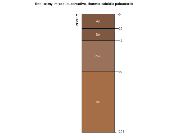
| Posey fine sandy loam, 0 to 1 percent slopes | PsA | 9149 | 1547921 | f5t4 | nm041 | 2014 | 1:24000 |
Posey fine sandy loam, 1 to 3 percent slopes | PsB | 6945 | 1547922 | f5t5 | nm041 | 2014 | 1:24000 |
Posey fine sandy loam, 3 to 8 percent slopes | PsC | 302 | 1884270 | f5vk | nm041 | 2014 | 1:24000 |
Posey fine sandy loam, 1 to 3 percent slopes | PsB | 20129 | 377740 | f5t5 | nm669 | 2005 | 1:24000 |
Posey fine sandy loam, 3 to 8 percent slopes | PsC | 17678 | 377741 | f5vk | nm669 | 2005 | 1:24000 |
Posey fine sandy loam, 0 to 1 percent slopes | PsA | 2700 | 377739 | f5t4 | nm669 | 2005 | 1:24000 |
Posey loam, moist, 1 to 3 percent slopes | PoB | 15356 | 362962 | 2x110 | tx033 | 1970 | 1:24000 |
Posey fine sandy loam, 1 to 3 percent slopes | PsB | 2143 | 2962314 | f5t5 | tx033 | 1970 | 1:24000 |
Posey loam, moist, 3 to 5 percent slopes | PoC | 772 | 362963 | 2x111 | tx033 | 1970 | 1:24000 |
Posey and Tulia loams, 3 to 12 percent slopes | PTD | 14294 | 3258053 | 1t1zl | tx045 | 1972 | 1:20000 |
Posey loam, 1 to 3 percent slopes | PoB | 3559 | 363774 | 308qy | tx069 | 1969 | 1:20000 |
Posey loam, 0 to 1 percent slopes | PoA | 3200 | 363773 | 308qx | tx069 | 1969 | 1:20000 |
Midessa and Posey fine sandy loams, 3 to 8 percent slopes | MPC | 1943 | 2931525 | f5sq | tx079 | 1962 | 1:20000 |
Posey fine sandy loam, 1 to 3 percent slopes | PsB | 1538 | 2931534 | f5t5 | tx079 | 1962 | 1:20000 |
Posey fine sandy loam, 0 to 1 percent slopes | PsA | 1416 | 2931533 | f5t4 | tx079 | 1962 | 1:20000 |
Midessa, Potter and Posey soils, 3 to 12 percent slopes | MPP | 1164 | 2931526 | f5sr | tx079 | 1962 | 1:20000 |
Posey fine sandy loam, 3 to 8 percent slopes | PsC | 80 | 2931535 | f5vk | tx079 | 1962 | 1:20000 |
Posey fine sandy loam, 1 to 3 percent slopes | PsB | 10269 | 393634 | f5t5 | tx115 | 2004 | 1:24000 |
Midessa and Posey fine sandy loams, 3 to 8 percent slopes | MPC | 7386 | 393618 | f5sq | tx115 | 2004 | 1:24000 |
Posey fine sandy loam, 0 to 1 percent slopes | PsA | 1931 | 393635 | f5t4 | tx115 | 2004 | 1:24000 |
Posey and Tulia loams, 3 to 12 percent slopes | PTD | 5702 | 695970 | 1t1zl | tx153 | 2004 | 1:24000 |
Posey fine sandy loam, 1 to 3 percent slopes | PsB | 194 | 1381233 | f5t5 | tx153 | 2004 | 1:24000 |
Posey fine sandy loam, 0 to 3 percent slopes | PoB | 492 | 366912 | 308pz | tx189 | 1969 | 1:20000 |
Posey fine sandy loam, 3 to 5 percent slopes | PoC | 425 | 366913 | 2tw3y | tx189 | 1969 | 1:20000 |
Posey fine sandy loam, 1 to 3 percent slopes | PsB | 18375 | 378994 | f5t5 | tx219 | 1999 | 1:24000 |
Posey fine sandy loam, 0 to 1 percent slopes | PsA | 2811 | 378993 | f5t4 | tx219 | 1999 | 1:24000 |
Midessa and Posey fine sandy loams, 3 to 8 percent slopes | MPC | 2611 | 379006 | f5sq | tx219 | 1999 | 1:24000 |
Posey fine sandy loam, 3 to 8 percent slopes | PsC | 1500 | 378995 | f5vk | tx219 | 1999 | 1:24000 |
Posey fine sandy loam, 1 to 3 percent slopes | PsB | 5759 | 369856 | f5t5 | tx303 | 1975 | 1:20000 |
Posey fine sandy loam, 0 to 1 percent slopes | PsA | 736 | 369855 | f5t4 | tx303 | 1975 | 1:20000 |
Posey fine sandy loam, 3 to 5 percent slopes | PsC | 565 | 369857 | 2tw3y | tx303 | 1975 | 1:20000 |
Posey fine sandy loam, 5 to 8 percent slopes | PsD | 414 | 369858 | 308q0 | tx303 | 1975 | 1:20000 |
Posey fine sandy loam, 1 to 3 percent slopes | PsB | 16949 | 379060 | f5t5 | tx305 | 1999 | 1:24000 |
Posey fine sandy loam, 0 to 1 percent slopes | PsA | 2700 | 379059 | f5t4 | tx305 | 1999 | 1:24000 |
Midessa and Posey fine sandy loams, 3 to 8 percent slopes | MPC | 844 | 379045 | f5sq | tx305 | 1999 | 1:24000 |
Midessa, Potter and Posey soils, 3 to 12 percent slopes | MPP | 639 | 379047 | f5sr | tx305 | 1999 | 1:24000 |
Posey-Mansker complex, 3 to 5 percent slopes | PnC | 1351 | 370889 | dfy5 | tx345 | 1972 | 1:24000 |
Posey clay loam, 0 to 3 percent slopes | PyB | 5104 | 3124158 | dg60 | tx359 | 1978 | 1:24000 |
Posey clay loam, 3 to 5 percent slopes | PyC | 345 | 3124159 | dg61 | tx359 | 1978 | 1:24000 |
Posey fine sandy loam, 3 to 8 percent slopes | PsC | 6062 | 2599147 | f5vk | tx369 | 1973 | 1:24000 |
Posey fine sandy loam, 1 to 3 percent slopes | PsB | 4076 | 2599136 | f5t5 | tx369 | 1973 | 1:24000 |
Posey fine sandy loam, 0 to 1 percent slopes | PsA | 1730 | 2599135 | f5t4 | tx369 | 1973 | 1:24000 |
Posey clay loam, 1 to 3 percent slopes | PyB | 9144 | 3124254 | 2mhvd | tx375 | 1974 | 1:24000 |
Posey clay loam, 3 to 5 percent slopes | PyC | 5409 | 3124255 | 2mhvf | tx375 | 1974 | 1:24000 |
Posey clay loam, 5 to 8 percent slopes | PyD | 574 | 3124256 | 2mhvg | tx375 | 1974 | 1:24000 |
Posey-Urban land complex | PyU | 139 | 3124257 | 2mhvh | tx375 | 1974 | 1:24000 |
Midessa and Posey fine sandy loams, 3 to 8 percent slopes | MPC | 7062 | 372576 | f5sq | tx445 | 1999 | 1:24000 |
Posey fine sandy loam, 1 to 3 percent slopes | PsB | 6387 | 372566 | f5t5 | tx445 | 1999 | 1:24000 |
Midessa, Potter and Posey soils, 3 to 12 percent slopes | MPP | 5261 | 372555 | f5sr | tx445 | 1999 | 1:24000 |
Posey fine sandy loam, 0 to 1 percent slopes | PsA | 3434 | 372565 | f5t4 | tx445 | 1999 | 1:24000 |
Posey fine sandy loam, 3 to 8 percent slopes | PsC | 3346 | 372595 | f5vk | tx445 | 1999 | 1:24000 |
Midessa, Potter and Posey soils, 3 to 12 percent slopes | MPP | 496 | 2931480 | f5sr | tx501 | 1962 | 1:31680 |
Posey fine sandy loam, 0 to 1 percent slopes | PsA | 268 | 2931491 | f5t4 | tx501 | 1962 | 1:31680 |
Midessa and Posey fine sandy loams, 3 to 8 percent slopes | MPC | 192 | 2931481 | f5sq | tx501 | 1962 | 1:31680 |
Posey fine sandy loam, 1 to 3 percent slopes | PsB | 167 | 2931492 | f5t5 | tx501 | 1962 | 1:31680 |