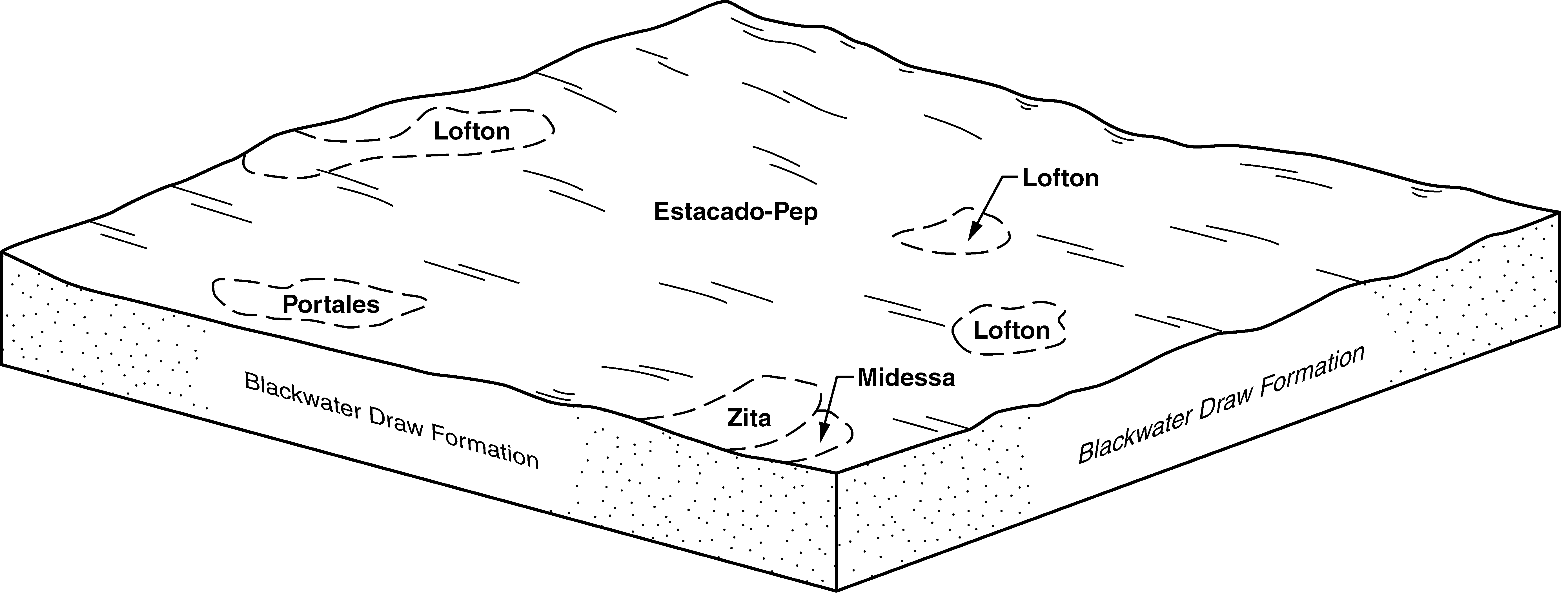
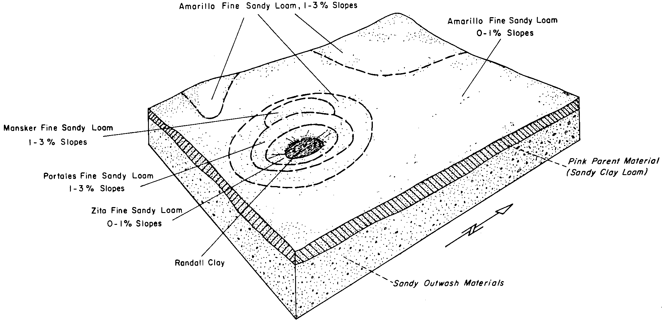
| Mansker-Portales association, gently sloping | MA | 22953 | 376361 | dmmp | nm021 | 1968 | 1:31680 |
Mansker-Portales association, cool, 0 to 9 percent slopes | MAcD | 5439 | 3156189 | 2xxx0 | nm021 | 1968 | 1:31680 |
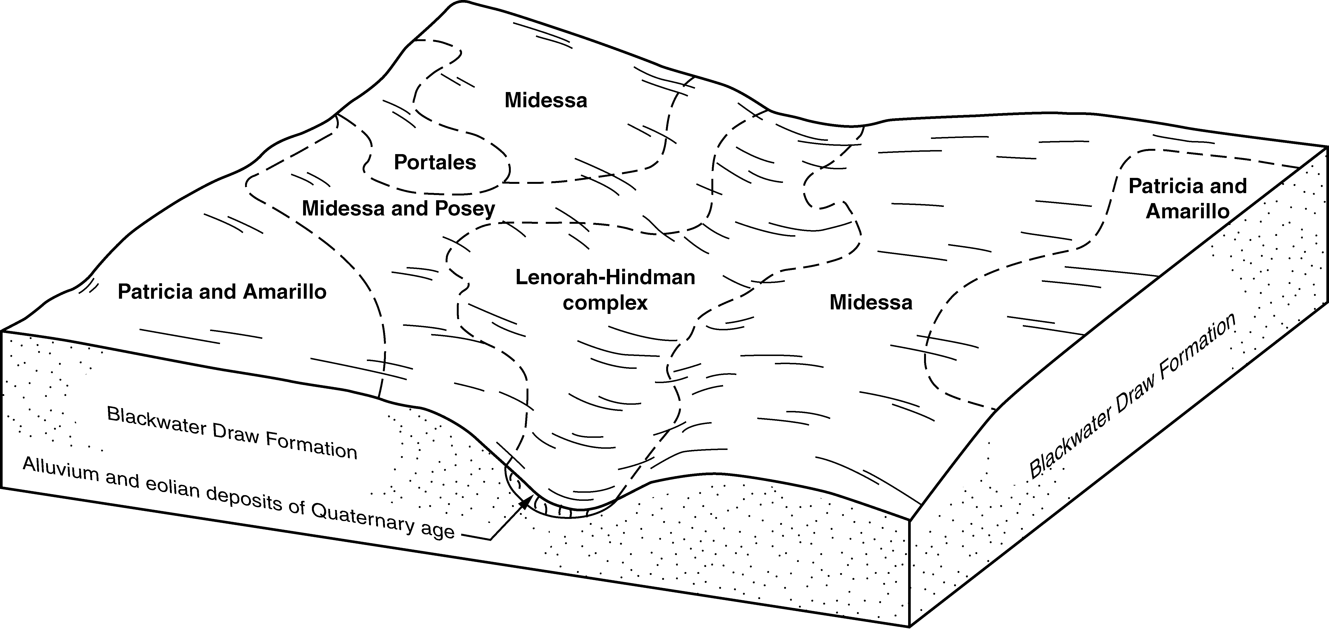
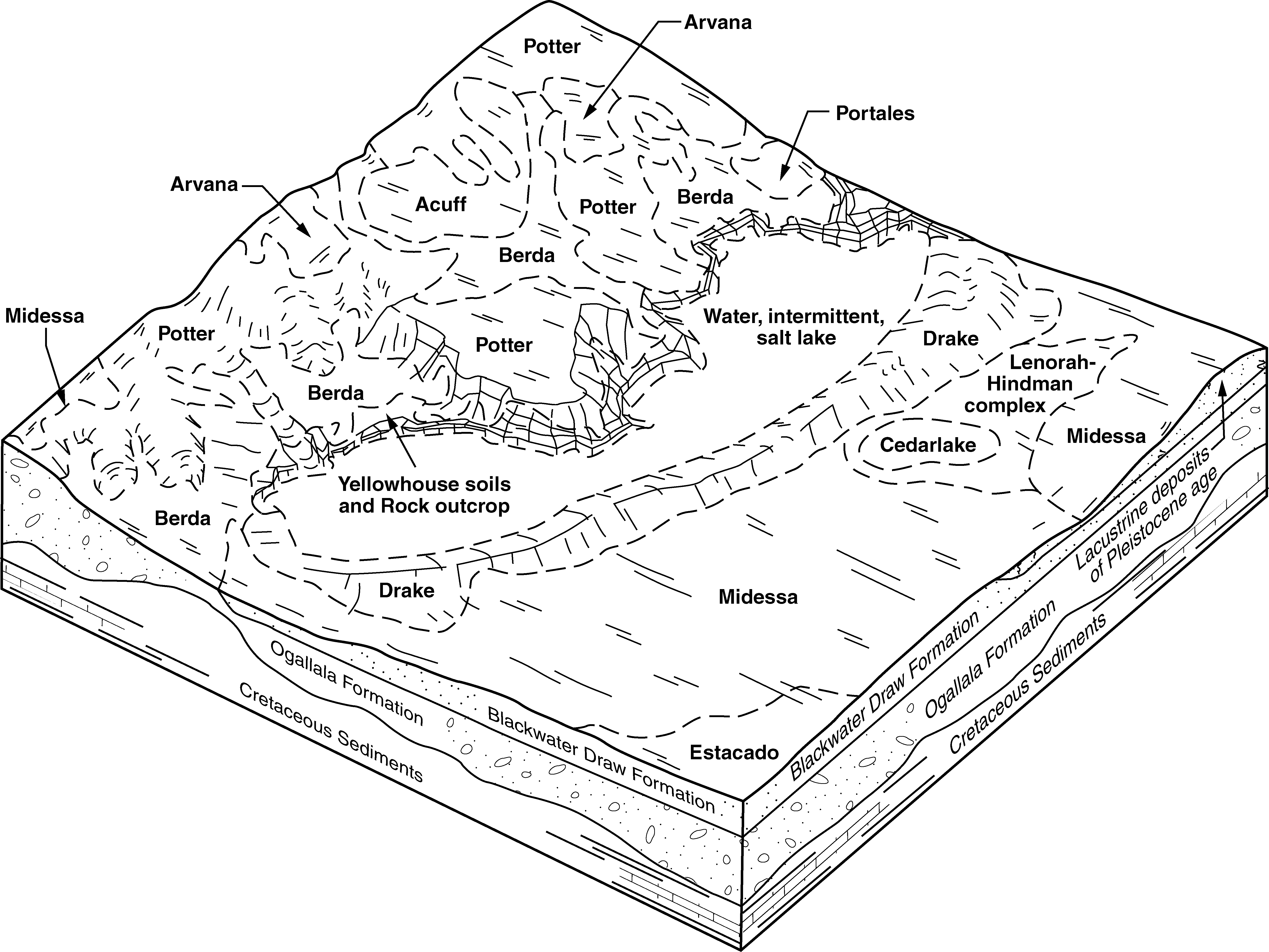
Portales-Stegall loams | PS | 50951 | 376453 | dmqn | nm025 | 1967 | 1:20000 |
Portales loam, 0 to 1 percent slopes | Ph | 28378 | 376460 | f5t2 | nm025 | 1967 | 1:20000 |
Portales loam, 0 to 3 percent slopes | PC | 26591 | 376451 | 2tmpb | nm025 | 1967 | 1:20000 |
Portales fine sandy loam, dry, 0 to 1 percent slopes | Pe | 8784 | 376458 | 2tmpj | nm025 | 1967 | 1:20000 |
Portales fine sandy loam, dry, 1 to 3 percent slopes | Pf | 2089 | 376459 | dmqv | nm025 | 1967 | 1:20000 |
Portales loam, 1 to 3 percent slopes | Po | 1126 | 376461 | f5t3 | nm025 | 1967 | 1:20000 |
Portales very fine sandy loam, 0 to 1 percent slopes | PvA | 11967 | 2520097 | 2q8fz | nm041 | 2014 | 1:24000 |
Portales very fine sandy loam, 1 to 3 percent slopes | PvB | 5868 | 2520098 | 2q8g0 | nm041 | 2014 | 1:24000 |
Ratliff-Portales, dry association, gently undulating | RAA | 2530 | 375795 | dm1f | nm644 | 1981 | 1:24000 |
Portales loam, 0 to 1 percent slopes | PoA | 4350 | 1427509 | f5t2 | nm669 | 2005 | 1:24000 |
Portales loam, 0 to 1 percent slopes | PmA | 27414 | 362600 | f5t2 | tx017 | 1960 | 1:20000 |
Portales loam, 1 to 3 percent slopes | PmB | 2290 | 362601 | f5t3 | tx017 | 1960 | 1:20000 |
Portales clay loam, 0 to 1 percent slopes | PrA | 1233 | 3258060 | db3m | tx045 | 1972 | 1:20000 |
Portales clay loam, 1 to 3 percent slopes | PrB | 274 | 3258066 | db3p | tx045 | 1972 | 1:20000 |
Portales loam, 0 to 1 percent slopes | PoA | 7297 | 363950 | f5t2 | tx079 | 1962 | 1:20000 |
Portales loam, 1 to 3 percent slopes | PoB | 1614 | 363951 | f5t3 | tx079 | 1962 | 1:20000 |
Portales loam, 1 to 3 percent slopes | PmB | 9237 | 364733 | f5t3 | tx107 | 1964 | 1:20000 |
Portales loam, 0 to 1 percent slopes | PmA | 7060 | 364732 | f5t2 | tx107 | 1964 | 1:20000 |
Portales loam, 1 to 3 percent slopes | PoB | 7916 | 393630 | f5t3 | tx115 | 2004 | 1:24000 |
Portales loam, 0 to 1 percent slopes | PoA | 7887 | 393631 | f5t2 | tx115 | 2004 | 1:24000 |
Portales clay loam, 0 to 1 percent slopes | PrA | 5245 | 378063 | db3m | tx117 | 1999 | 1:24000 |
Portales loam, 0 to 1 percent slopes | PoA | 678 | 365139 | d7yp | tx125 | 1965 | 1:20000 |
Portales clay loam, 0 to 1 percent slopes | PrA | 2094 | 695967 | db3m | tx153 | 2004 | 1:24000 |
Portales loam, 0 to 1 percent slopes | PmA | 3007 | 366046 | f5t2 | tx165 | 1964 | 1:20000 |
Portales loam, 0 to 1 percent slopes | PoA | 2432 | 378350 | f5t2 | tx169 | 1965 | 1:24000 |
Portales loam, 1 to 3 percent slopes | PoB | 921 | 378351 | f5t3 | tx169 | 1965 | 1:24000 |
Portales loam, 1 to 3 percent slopes | PoB | 23024 | 378992 | f5t3 | tx219 | 1999 | 1:24000 |
Portales loam, 0 to 1 percent slopes | PoA | 18722 | 378991 | f5t2 | tx219 | 1999 | 1:24000 |
Portales loam, 0 to 1 percent slopes | PoA | 33119 | 391899 | f5t2 | tx227 | 1965 | 1:24000 |
Portales loam, 1 to 3 percent slopes | PoB | 18439 | 391900 | f5t3 | tx227 | 1965 | 1:24000 |
Portales loam, 0 to 1 percent slopes | PmA | 21664 | 394293 | f5t2 | tx279 | 1960 | 1:20000 |
Portales loam, 1 to 3 percent slopes | PmB | 8406 | 394294 | f5t3 | tx279 | 1960 | 1:20000 |
Portales loam, 0 to 1 percent slopes | PoA | 3681 | 369854 | f5t2 | tx303 | 1975 | 1:20000 |
Portales loam, 1 to 3 percent slopes | PoB | 9112 | 379058 | f5t3 | tx305 | 1999 | 1:24000 |
Portales loam, 0 to 1 percent slopes | PoA | 6600 | 379057 | f5t2 | tx305 | 1999 | 1:24000 |
Portales loam, 0 to 1 percent slopes | PoA | 37033 | 370348 | f5t2 | tx317 | 1968 | 1:24000 |
Portales loam, 1 to 3 percent slopes | PoB | 3961 | 370349 | f5t3 | tx317 | 1968 | 1:24000 |
Portales loam, 0 to 1 percent slopes | PoA | 4509 | 370642 | f5t2 | tx329 | 1966 | 1:31680 |
Portales loam, 1 to 3 percent slopes | PoB | 149 | 2599134 | f5t3 | tx369 | 1973 | 1:24000 |
Portales loam, 0 to 1 percent slopes | PoA | 139 | 2599133 | f5t2 | tx369 | 1973 | 1:24000 |
Portales clay loam, 1 to 3 percent slopes | PrB | 1839 | 371406 | dggv | tx381 | 1999 | 1:24000 |
Portales clay loam, 0 to 1 percent slopes | PrA | 1759 | 628519 | db3m | tx381 | 1999 | 1:24000 |
Portales-Urban land complex | PrU | 121 | 643366 | plgr | tx381 | 1999 | 1:24000 |
Portales loam, 1 to 3 percent slopes | PoB | 3951 | 372564 | f5t3 | tx445 | 1999 | 1:24000 |
Portales loam, 0 to 1 percent slopes | PoA | 2314 | 372563 | f5t2 | tx445 | 1999 | 1:24000 |
Portales loam, 0 to 1 percent slopes | PoA | 5508 | 373733 | f5t2 | tx501 | 1962 | 1:31680 |
Portales loam, 1 to 3 percent slopes | PoB | 208 | 2931490 | f5t3 | tx501 | 1962 | 1:31680 |