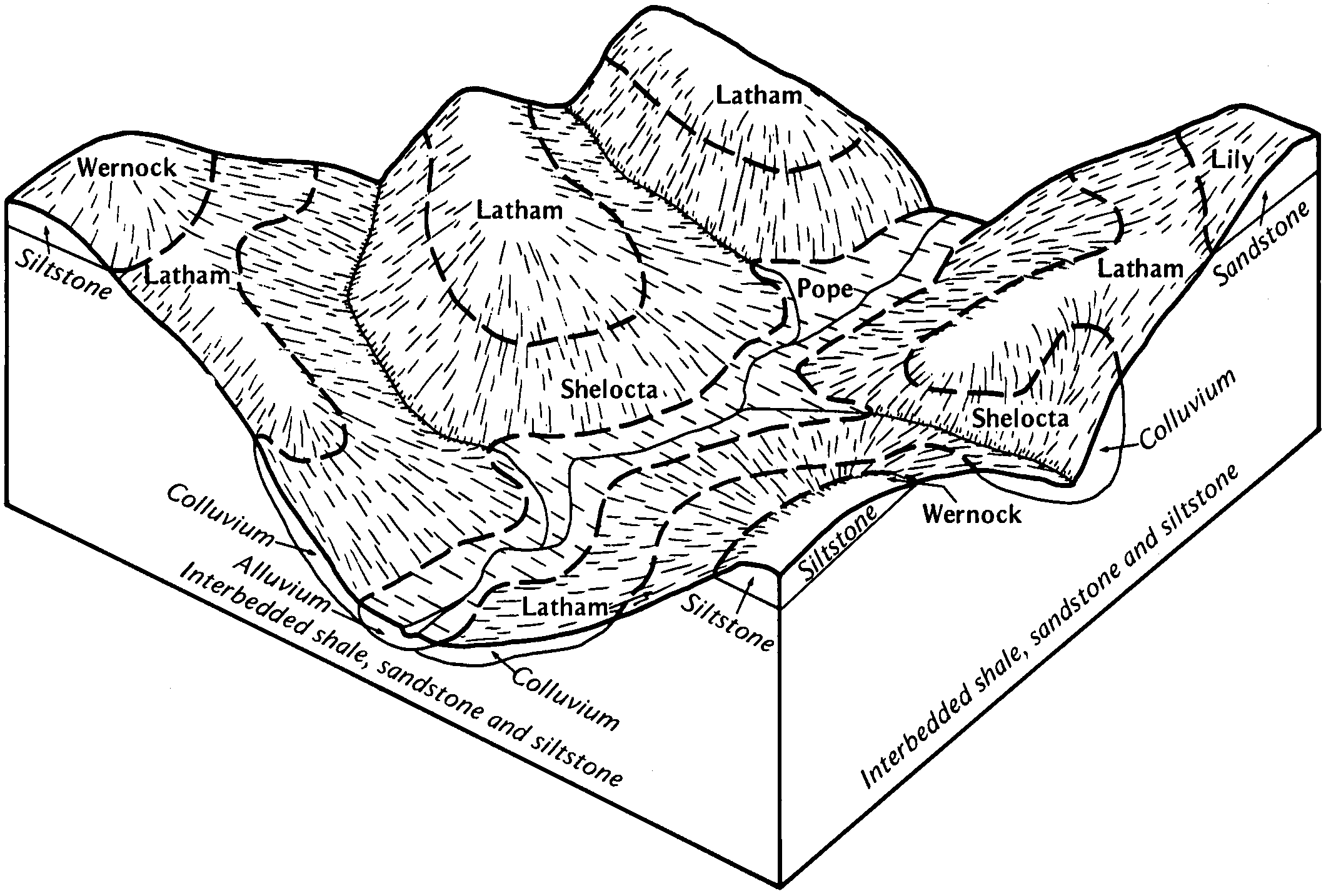
| Pope silt loam, 0 to 2 percent slopes | PpA | 1709 | 523373 | kkm0 | al015 | 1959 | 1:20000 |
Pope fine sandy loam, 0 to 2 percent slopes | PoA | 1268 | 523372 | kklz | al015 | 1959 | 1:20000 |
Pope fine sandy loam | Po | 1377 | 328938 | c18x | al043 | 1960 | 1:20000 |
Pope loam | Pe | 500 | 329203 | c1kg | al049 | 1953 | 1:20000 |
Pope fine sandy loam | Pf | 190 | 522942 | kk53 | al071 | 1943 | 1:24000 |
Pope fine sandy loam | Pb | 111 | 330741 | c352 | al095 | 1956 | 1:20000 |
Pope fine sandy loam | Pg | 664 | 331143 | c3l1 | al103 | 1949 | 1:15840 |
Pope fine sandy loam, 0 to 2 percent slopes, frequently flooded, very brief duration | PrwAV | 802 | 166260 | 5l07 | in119 | 1997 | 1:12000 |
Pope fine sandy loam, 0 to 3 percent slopes, frequently flooded | Po | 4934 | 550256 | 2xb01 | ky043 | 1980 | 1:20000 |
Pope fine sandy loam, occasionally flooded | Pr | 4180 | 552532 | ljym | ky051 | 1994 | 1:24000 |
Pope loam, occasionally flooded | Pp | 1967 | 552531 | ljyl | ky051 | 1994 | 1:24000 |
Pope loam, rarely flooded | Po | 1063 | 552530 | ljyk | ky051 | 1994 | 1:24000 |
Pope fine sandy loam, occasionally flooded | Po | 638 | 551269 | lhmw | ky183 | 1983 | 1:20000 |
Pope fine sandy loam | Po | 923 | 552449 | ljvy | ky199 | 1969 | 1:12000 |
Pope gravelly silt loam, 0 to 3 percent slopes, frequently flooded | Pg | 5258 | 550417 | 2xb09 | ky605 | 1975 | 1:20000 |
Pope fine sandy loam, 0 to 3 percent slopes, frequently flooded | Pf | 4574 | 550416 | 2xb01 | ky605 | 1975 | 1:20000 |
Pope gravelly fine sandy loam, frequently flooded | Pg | 813 | 552227 | ljms | ky627 | 1984 | 1:20000 |
Pope fine sandy loam | Po | 1401 | 552286 | ljpp | ky628 | 1973 | 1:20000 |
Pope soils, 0 to 4 percent slopes, frequently flooded | 15 | 2059 | 964546 | 11cpd | ky630 | 1966 | 1:15840 |
Pope fine sandy loam, occasionally flooded | Po | 5146 | 552127 | ljjk | ky638 | 1989 | 1:24000 |
Pope loam, 0 to 2 percent slopes, frequently flooded | Po | 3419 | 550951 | 2xb06 | ky641 | 1994 | 1:24000 |
Pope fine sandy loam, 0 to 2 percent slopes, occasionally flooded | Po | 1660 | 1478810 | 2x9zy | ky645 | 1971 | 1:20000 |
Pope gravelly fine sandy loam, 0 to 2 percent slopes, occasionally flooded | Pp | 730 | 1478811 | 2xb02 | ky645 | 1971 | 1:20000 |
Stendal fine sandy loam, neutral variant (pope) | Sv | 560 | 1478827 | 1lmv3 | ky645 | 1971 | 1:20000 |
Pope fine sandy loam, 0 to 3 percent slopes, occasionally flooded | PoA | 902 | 2401228 | 2llnz | md001 | 2009 | 1:12000 |
Pope silt loam, 0 to 3 percent slopes, occasionally flooded | Ps | 530 | 532939 | 2sftl | md023 | 1970 | 1:20000 |
Pope fine sandy loam | Pn | 874 | 534629 | kyb3 | md043 | 1998 | 1:12000 |
Pope gravelly loam | Po | 254 | 534631 | kyb5 | md043 | 1998 | 1:12000 |
Pope fine sandy loam, high bottom, 0 to 2 percent slopes, occasionally flooded | PomAs | 1986 | 1482392 | 1lrk3 | nj019 | 1970 | 1:24000 |
Pope fine sandy loam, high bottom, 0 to 2 percent slopes, occasionally flooded | PomAs | 129 | 1482391 | 1lrk2 | nj021 | 1969 | 1:24000 |
Pope fine sandy loam, 0 to 3 percent slopes | 292A | 60 | 1860012 | 20fhd | ny003 | 2013 | 1:24000 |
Pope fine sandy loam, 0 to 3 percent slopes, occasionally flooded | 18A | 293 | 1540796 | 2sft6 | ny009 | 2002 | 1:24000 |
Pope very fine sandy loam, rarely flooded | Pp | 709 | 295116 | 9x2w | ny105 | 1984 | 1:15840 |
Pope silt loam, occasionally flooded | Po | 539 | 295115 | 9x2v | ny105 | 1984 | 1:15840 |
Pope-Stokly silt loams, 0 to 3 percent slopes, frequently flooded | PpS1AF | 840 | 2441854 | 2myyh | oh009 | 1981 | 1:15840 |
Pope-Stokly silt loams, 0 to 3 percent slopes, frequently flooded | PpS1AF | 3291 | 2450443 | 2n7wk | oh053 | 1988 | 1:15840 |
Pope fine sandy loam, 0 to 3 percent slopes, frequently flooded | Pop6AF | 2297 | 2450441 | 2xb01 | oh053 | 1988 | 1:15840 |
Pope silt loam, 0 to 3 percent slopes, occasionally flooded | Pop1AO | 1232 | 2450442 | 2xb07 | oh053 | 1988 | 1:15840 |
Pope silt loam, 0 to 3 percent slopes, frequently flooded | Pop1AF | 95 | 2450770 | 2xb08 | oh053 | 1988 | 1:15840 |
Pope loam, 0 to 3 percent slopes, occasionally flooded | Po | 2169 | 1398093 | 2xb05 | oh073 | 1986 | 1:15840 |
Pope-Stokly silt loams, 0 to 3 percent slopes, frequently flooded | PpS1AF | 1604 | 2450656 | 2n83f | oh073 | 1986 | 1:15840 |
Pope silt loam, 0 to 3 percent slopes, frequently flooded | Px | 2310 | 536033 | 2xb08 | oh079 | 1981 | 1:15840 |
Pope sandy loam, 0 to 3 percent slopes, frequently flooded | Pv | 2302 | 536031 | 2xb04 | oh079 | 1981 | 1:15840 |
Pope silt loam, 0 to 3 percent slopes, frequently flooded | Pop1AF | 1120 | 2451029 | 2n8hg | oh079 | 1981 | 1:15840 |
Pope fine sandy loam, 0 to 2 percent slopes, rarely flooded | Pw | 503 | 536032 | 2x9zz | oh079 | 1981 | 1:15840 |
Pope fine sandy loam, 0 to 3 percent slopes, frequently flooded | Pop6AF | 142 | 2451027 | 2xb01 | oh079 | 1981 | 1:15840 |
Pope loam, 0 to 2 percent slopes, frequently flooded | Py | 116 | 1460500 | 2xb06 | oh079 | 1981 | 1:15840 |
Pope fine sandy loam, 0 to 3 percent slopes, rarely flooded | Pop6AR | 18 | 2451028 | 2n8hf | oh079 | 1981 | 1:15840 |
Pope-Stokly silt loams, 0 to 3 percent slopes, frequently flooded | PpS1AF | 2594 | 2451110 | 2n8l2 | oh087 | 1989 | 1:15840 |
Pope silt loam, 0 to 3 percent slopes, frequently flooded | Pop1AF | 744 | 2452590 | 2xb08 | oh087 | 1989 | 1:15840 |
Pope silt loam, frequently flooded | Px | 11 | 1455084 | 1kv46 | oh087 | 1989 | 1:15840 |
Pope silt loam, 0 to 3 percent slopes, frequently flooded | Pop1AF | 238 | 2451284 | 2xb08 | oh105 | 1991 | 1:15840 |
Pope-Stokly silt loams, 0 to 3 percent slopes, frequently flooded | PpS1AF | 190 | 2451285 | 2n8rq | oh105 | 1991 | 1:15840 |
Pope sandy loam, 0 to 3 percent slopes, frequently flooded | Po | 27 | 1689037 | 2xb04 | oh131 | 1984 | 1:15840 |
Pope silt loam, 0 to 3 percent slopes, frequently flooded | Pp | 21 | 170941 | 2xb08 | oh141 | 1997 | 1:15840 |
Pope loam, 0 to 2 percent slopes, frequently flooded | Po | 4116 | 536419 | 2xb06 | oh163 | 1998 | 1:15840 |
Pope silt loam, 0 to 3 percent slopes, frequently flooded | Pop1AF | 2176 | 2453372 | 2xb08 | oh163 | 1998 | 1:15840 |
Pope-Stokly silt loams, 0 to 3 percent slopes, frequently flooded | PpS1AF | 1866 | 2453374 | 2nby3 | oh163 | 1998 | 1:15840 |
Pope fine sandy loam, 0 to 3 percent slopes, frequently flooded | Pop6AF | 1750 | 2453371 | 2xb01 | oh163 | 1998 | 1:15840 |
Pope loam, 0 to 3 percent slopes, occasionally flooded | Pn | 176 | 536418 | 2xb05 | oh163 | 1998 | 1:15840 |
Pope loam, 0 to 3 percent slopes, occasionally flooded | PoA | 1983 | 1678229 | 2xb05 | pa005 | 2012 | 1:24000 |
Pope fine sandy loam, 0 to 2 percent slopes, rarely flooded | PmA | 819 | 1678228 | 2x9zz | pa005 | 2012 | 1:24000 |
Pope silt loam, 0 to 3 percent slopes, occasionally flooded | Po | 1246 | 2900296 | 2xb07 | pa007 | 1978 | 1:15840 |
Pope fine sandy loam | Pp | 1470 | 541851 | l5v2 | pa009 | 1989 | 1:24000 |
Pope loam, 0 to 3 percent slopes, occasionally flooded | Po | 408 | 538202 | 2xb05 | pa019 | 1984 | 1:15840 |
Pope silt loam, 0 to 3 percent slopes, occasionally flooded | Po | 640 | 541934 | 2sftl | pa021 | 1978 | 1:20000 |
Pope soils | Po | 1454 | 538343 | l25x | pa027 | 1975 | 1:20000 |
Pope fine sandy loam, 0 to 2 percent slopes, rarely flooded | PmA | 863 | 3180050 | 2x9zz | pa031 | 2012 | 1:24000 |
Pope silt loam, 0 to 3 percent slopes, occasionally flooded | PoA | 510 | 557469 | 2xb07 | pa031 | 2012 | 1:24000 |
Pope loam, 0 to 3 percent slopes, occasionally flooded | Po | 1429 | 538546 | 2sftf | pa033 | 1981 | 1:20000 |
Pope loam | Po | 3815 | 296188 | 9y6g | pa039 | 1973 | 1:20000 |
Pope silt loam | Po | 626 | 545187 | l99p | pa055 | 1999 | 1:24000 |
Pope silt loam | Po | 550 | 544925 | l917 | pa057 | 1999 | 1:24000 |
Pope fine sandy loam, 0 to 2 percent slopes, rarely flooded | PmA | 1817 | 3180051 | 2x9zz | pa063 | 2012 | 1:24000 |
Pope silt loam, 0 to 3 percent slopes, occasionally flooded | PoA | 1622 | 1720904 | 2xb07 | pa063 | 2012 | 1:24000 |
Pope fine sandy loam, 0 to 2 percent slopes, rarely flooded | PmA | 280 | 3180052 | 2x9zz | pa065 | 2012 | 1:12000 |
Pope silt loam, 0 to 3 percent slopes, occasionally flooded | PoA | 196 | 2399003 | 2xb07 | pa065 | 2012 | 1:12000 |
Pope soils | Po | 657 | 299333 | b1gx | pa069 | 1976 | 1:20000 |
Pope soils, rarely flooded | Pp | 370 | 299334 | b1gy | pa069 | 1976 | 1:20000 |
Pope silt loam, 0 to 3 percent slopes, occasionally flooded | Po | 24 | 2900448 | 2xb07 | pa073 | 1978 | 1:15840 |
Pope loam | Po | 523 | 541326 | l594 | pa075 | 1976 | 1:20000 |
Pope soils | Ps | 8969 | 296478 | 9yht | pa079 | 1974 | 1:20000 |
Pope loam, 0 to 3 percent slopes, occasionally flooded | Po | 3015 | 539917 | 2sftf | pa083 | 1984 | 1:20000 |
Pope silt loam | Po | 1882 | 296349 | 9ycn | pa089 | 1975 | 1:20000 |
Pope silt loam, high bottom | Pp | 1719 | 296350 | 9ycp | pa089 | 1975 | 1:20000 |
Pope loam, terrace, 0 to 3 percent slopes | PpA | 18 | 1479565 | 1lnlx | pa101 | 1971 | 1:15840 |
Pope fine sandy loam | 15 | 208 | 297192 | 9z7v | pa103 | 1995 | 1:24000 |
Pope silt loam | Po | 163 | 539751 | l3nb | pa107 | 1977 | 1:20000 |
Pope fine sandy loam, 0 to 3 percent slopes, occasionally flooded | Po | 1569 | 542108 | 2sft6 | pa111 | 1977 | 1:20000 |
Pope soils | Po | 9432 | 297153 | 9z6l | pa117 | 1973 | 1:20000 |
Pope fine sandy loam, high bottom | Pp | 1354 | 297154 | 9z6m | pa117 | 1973 | 1:20000 |
Pope loam, 0 to 3 percent slopes, occasionally flooded | Po | 3849 | 538940 | 2sftf | pa121 | 1971 | 1:20000 |
Pope soils, rarely flooded | Pp | 3927 | 301963 | b46r | pa131 | 1976 | 1:20000 |
Pope soils | Po | 599 | 301962 | b46q | pa131 | 1976 | 1:20000 |
Pope soils | Po | 1034 | 545533 | l9nv | pa605 | 1975 | 1:20000 |
Pope silt loam, 0 to 3 percent slopes, occasionally flooded | Po | 1289 | 539193 | 2sftl | pa607 | 1986 | 1:20000 |
Pope loam, 0 to 3 percent slopes, occasionally flooded | Po | 1855 | 539259 | 2sftf | pa609 | 1979 | 1:20000 |
Pope soils | Po | 8494 | 296779 | 9ytj | pa610 | 1978 | 1:20000 |
Pope-Philo complex, frequently flooded | Pp | 1410 | 1887363 | 21byp | tn001 | 1978 | 1:15840 |
Craigsville-Pope complex, 0 to 4 percent slopes, occasionally flooded | Cw | 463 | 1887379 | 21bz6 | tn001 | 1978 | 1:15840 |
Pope fine sandy loam | Po | 686 | 524541 | kltp | tn025 | 1948 | 1:24000 |
Pope fine sandy loam | Pf | 646 | 527581 | kpzr | tn085 | 1943 | 1:20000 |
Barbourville loam (Pope) | Ba | 2104 | 526228 | knl3 | tn115 | 1951 | 1:20000 |
Pope loam | Po | 1494 | 527921 | kqbq | tn123 | 1974 | 1:20000 |
Pope and Philo loams, frequently flooded | Pp | 510 | 728876 | sgg4 | tn143 | 2003 | 1:24000 |
Pope-Philo complex, frequently flooded | Pp | 237 | 1473544 | 1lgbp | tn145 | 2005 | 1:24000 |
Pope fine sandy loam | Po | 329 | 529990 | kshg | tn173 | 1945 | 1:24000 |
Pope sandy loam, occasionally flooded | Po | 794 | 524824 | km3t | tn606 | 2001 | 1:24000 |
Pope-Philo complex, frequently flooded | Pp | 6064 | 530680 | kt6q | tn607 | 2003 | 1:24000 |
Pope sandy loam, occasionally flooded | Po | 2766 | 529701 | ks64 | tn608 | 2001 | 1:24000 |
Pope-Philo complex, frequently flooded | Pp | 3114 | 2439108 | 2mw2x | tn629 | 2003 | 1:24000 |
Pope-Skidmore complex, 0 to 4 percent slopes, frequently flooded | Ps | 1652 | 2217353 | 2dfbj | tn650 | 2008 | 1:12000 |
Ogles-Pope-Philo complex, 0 to 3 percent slopes, occasionally flooded | 25A | 2150 | 1402658 | 1j2l1 | va021 | 2005 | 1:24000 |
Pope fine sandy loam, 0 to 3 percent slopes, occasionally flooded | 29A | 1538 | 1402663 | 1j2l6 | va021 | 2005 | 1:24000 |
Pope fine sandy loam, 0 to 3 percent slopes, frequently flooded | 31A | 2370 | 2481038 | 2p8qh | va045 | 2010 | 1:24000 |
Pope fine sandy loam, 0 to 3 percent slopes, occasionally flooded | 26A | 510 | 521709 | khwb | va105 | 1997 | 1:24000 |
Pope fine sandy loam, 0 to 3 percent slopes, occasionally flooded | 55A | 1022 | 2514842 | 2qdcd | va163 | 2010 | 1:24000 |
Pope fine sandy loam, 0 to 2 percent slopes, rarely flooded | 45A | 1231 | 522111 | kj99 | va185 | 1996 | 1:24000 |
Pope fine sandy loam, 0 to 3 percent slopes, occasionally flooded | 4 | 594 | 2435461 | 2mr98 | va606 | | 1:24000 |
Pope fine sandy loam, 0 to 3 percent slopes, occasionally flooded | Pn | 850 | 513263 | 2xb00 | wv001 | 1965 | 1:12000 |
Pope fine sandy loam | Ps | 790 | 516273 | kb6z | wv003 | 1997 | 1:24000 |
Pope silt loam | Px | 733 | 516274 | kb70 | wv003 | 1997 | 1:24000 |
Pope sandy loam, 0 to 3 percent slopes, occasionally flooded | Po | 1755 | 513066 | 2xb03 | wv007 | 1990 | 1:24000 |
Pope-Craigsville complex | Px | 4770 | 516106 | kb1l | wv015 | 1998 | 1:24000 |
Pope sandy loam, 0 to 3 percent slopes, occasionally flooded | Po | 1699 | 516105 | 2xb03 | wv015 | 1998 | 1:24000 |
Pope fine sandy loam, warm, 0 to 3 percent slopes, occasionally flooded | Po | 1182 | 553007 | 2sft7 | wv025 | 2002 | 1:24000 |
Pope fine sandy loam, moist, 0 to 3 percent slopes, occasionally flooded | Po | 313 | 514818 | 2sfsz | wv041 | 1989 | 1:20000 |
Pope fine sandy loam, warm, 0 to 3 percent slopes, occasionally flooded | Po | 472 | 1716689 | 2sft7 | wv063 | 1962 | 1:24000 |
Pope-Philo fine sandy loams | Pz | 1047 | 555757 | ln9n | wv065 | 2003 | 1:24000 |
Pope fine sandy loam | Ps | 493 | 555672 | ln6x | wv065 | 2003 | 1:24000 |
Pope silt loam | Px | 128 | 555673 | ln6y | wv065 | 2003 | 1:24000 |
Pope gravelly silt loam, 0 to 3 percent slopes, occasionally flooded | Pg | 1824 | 1868113 | 2vxhm | wv077 | 1955 | 1:20000 |
Pope fine sandy loam, 0 to 3 percent slopes, occasionally flooded | Pf | 950 | 1868112 | 2sft6 | wv077 | 1955 | 1:20000 |
Pope silt loam, 0 to 3 percent slopes, occasionally flooded | Po | 575 | 1868114 | 2sftl | wv077 | 1955 | 1:20000 |
Pope fine sandy loam, moist, 0 to 3 percent slopes, occasionally flooded | Po | 971 | 515496 | 2sfsz | wv097 | 1981 | 1:20000 |
Pope-Potomac complex, very cobbly | Pp | 3996 | 515147 | k91n | wv101 | 1992 | 1:24000 |
Pope loam, moist, 0 to 3 percent slopes, occasionally flooded | Po | 2376 | 515146 | 2sftc | wv101 | 1992 | 1:24000 |
Philo-Pope complex, moist, 0 to 3 percent slopes, occasionally flooded | Pe | 1201 | 515144 | 2vxhk | wv101 | 1992 | 1:24000 |
Barbour and Pope gravelly sandy loams | BC | 2336 | 513961 | k7td | wv602 | 1965 | 1:20000 |
Linden and Pope fine sandy loams | LP | 1218 | 1913599 | 22780 | wv602 | 1965 | 1:20000 |
Barbour and Pope fine sandy loams, rarely flooded | BB | 863 | 513960 | k7tc | wv602 | 1965 | 1:20000 |
Barbour and Pope gravelly sandy loams, rarely flooded | BD | 594 | 513962 | k7tf | wv602 | 1965 | 1:20000 |
Barbour and Pope cobbly loamy sands | BF | 89 | 513963 | k7tg | wv602 | 1965 | 1:20000 |
Pope-Atkins complex | Pn | 6215 | 515598 | k9j6 | wv603 | 1978 | 1:20000 |
Pope and Linden fine sandy loams | Po | 2543 | 515599 | k9j7 | wv603 | 1978 | 1:20000 |
Pope variant gravelly sandy loam | Pv | 2163 | 515600 | k9j8 | wv603 | 1978 | 1:20000 |
Pope fine sandy loam | Pm | 4964 | 555970 | lnjj | wv608 | 1973 | 1:20000 |
Pope gravelly sandy loam | Ps | 2341 | 555972 | lnjl | wv608 | 1973 | 1:20000 |
Pope silt loam | Po | 580 | 555971 | lnjk | wv608 | 1973 | 1:20000 |
Pope silt loam, 0 to 3 percent slopes, occasionally flooded | Po | 234 | 515824 | 2xb07 | wv610 | 1973 | 1:20000 |
Pope variant sandy loam | Pv | 923 | 514399 | k88j | wv611 | 1977 | 1:20000 |
Pope-Craigsville complex, 0 to 3 percent slopes, occasionally flooded | PvA | 85 | 2248428 | 2fgny | wv621 | 2010 | 1:12000 |
Pope sandy loam, 0 to 3 percent slopes, rarely flooded | PsA | 35 | 2479904 | 2p7jx | wv621 | 2010 | 1:12000 |
Philo-Pope complex, 0 to 3 percent slopes, occasionally flooded | PhA | 34 | 2427095 | 2q6sq | wv622 | 2010 | 1:12000 |
Philo-Pope complex, warm, 0 to 3 percent slopes, occasionally flooded | PhA | 5252 | 2453198 | 2vxhl | wv705 | 2009 | 1:24000 |
Pope-Craigsville complex, 0 to 3 percent slopes, occasionally flooded | PvA | 5104 | 2453197 | 2nbrd | wv705 | 2009 | 1:24000 |
Pope fine sandy loam, warm, 0 to 3 percent slopes, occasionally flooded | PoA | 1055 | 2453196 | 2sft7 | wv705 | 2009 | 1:24000 |
Urban land-Pope-Udorthents complex, 0 to 3 percent slopes, occasionally flooded | UxA | 662 | 2453266 | 2nbtm | wv705 | 2009 | 1:24000 |
Pope-Craigsville complex | Pr | 3829 | 2514104 | k7m1 | wv767 | 2011 | 1:20000 |