| Pookaloo-Cavehill-Rock outcrop association | 100 | 1073 | 2634002 | 2rhht | nv621 | 1971 | 1:24000 |
Pookaloo-Tecomar-Rock outcrop association MLRA 28B | 108 | 359 | 2634001 | 2t6gk | nv621 | 1971 | 1:24000 |
Pookaloo-Cavehill-Rock outcrop association | 100 | 10979 | 2589840 | 2r35q | nv764 | 2021 | 1:24000 |
Pookaloo-Cavehill, moist-Rock outcrop association | 572 | 3887 | 2928242 | 2w2t2 | nv764 | 2021 | 1:24000 |
Onkeyo-Pookaloo-Tecomar association | 532 | 804 | 2511438 | 2q8zs | nv764 | 2021 | 1:24000 |
Tecomar-Tecomar, dry-Pookaloo association | 67 | 258 | 2928233 | 2w2sr | nv764 | 2021 | 1:24000 |
Pookaloo-Cavehill-Rock outcrop association | 575 | 148976 | 478393 | 2t6gm | nv766 | 1994 | 1:24000 |
Tecomar-Tecomar, dry-Pookaloo association | 67 | 64608 | 478191 | j1lj | nv766 | 1994 | 1:24000 |
Pookaloo-Tecomar-Rock outcrop association MLRA 28B | 1430 | 35132 | 478640 | 2t6gk | nv766 | 1994 | 1:24000 |
Onkeyo-Pookaloo-Tecomar association | 532 | 17879 | 478372 | 2t6gj | nv766 | 1994 | 1:24000 |
Pookaloo-Cavehill, cool-Rock outcrop association | 1630 | 16563 | 478674 | j233 | nv766 | 1994 | 1:24000 |
Tecomar-Pookaloo association | 1250 | 15559 | 478615 | 2t6x2 | nv766 | 1994 | 1:24000 |
Pookaloo-Tecomar-Onkeyo association | 576 | 15355 | 478394 | j1t2 | nv766 | 1994 | 1:24000 |
Zimbob-Pookaloo association | 972 | 14006 | 478546 | j1yz | nv766 | 1994 | 1:24000 |
Zimbob-Tecomar-Pookaloo association | 974 | 10104 | 478548 | j1z1 | nv766 | 1994 | 1:24000 |
Pharo-Bobs-Pookaloo association | 1161 | 9514 | 478590 | j20d | nv766 | 1994 | 1:24000 |
Onkeyo-Amene-Pookaloo association | 600 | 9244 | 478402 | j1tb | nv766 | 1994 | 1:24000 |
Tecomar-Pookaloo-Pharo association | 203 | 6845 | 478259 | j1nq | nv766 | 1994 | 1:24000 |
Pookaloo-Tecomar-Wardbay association | 1631 | 5685 | 478675 | j234 | nv766 | 1994 | 1:24000 |
Onkeyo-Adobe-Pookaloo association | 1220 | 5576 | 478611 | j212 | nv766 | 1994 | 1:24000 |
Pookaloo-Cavehill, moist-Rock outcrop association | 572 | 2 | 2928271 | 2w2v0 | nv766 | 1994 | 1:24000 |
Pookaloo-Cavehill-Rock outcrop association | 2771 | 981 | 479150 | 2t6gm | nv768 | 1985 | 1:63360 |
Pookaloo-Cavehill-Rock outcrop association | 1360 | 18455 | 475210 | 2t6gm | nv769 | 1986 | 1:24000 |
Pookaloo-Cavehill-Rock outcrop association | 2771 | 2365 | 479581 | 2t6gm | nv775 | 1985 | 1:24000 |
Pookaloo-Tecomar-Cavehill association | 1142 | 23180 | 2215827 | 2dcr9 | nv778 | 2013 | 1:24000 |
Tecomar-Pookaloo-Zimbob association | 6120 | 22518 | 2215771 | 2whnf | nv778 | 2013 | 1:24000 |
Pookaloo-Cavehill-Rock outcrop association | 6100 | 21355 | 2215767 | 2t6gm | nv778 | 2013 | 1:24000 |
Mijoysee-Pookaloo-Tecomar association | 6201 | 19639 | 2215776 | 2dcpn | nv778 | 2013 | 1:24000 |
Tecomar-Zimbob-Pookaloo association | 1144 | 15126 | 2215828 | 2dcrb | nv778 | 2013 | 1:24000 |
Tecomar-Adobe-Pookaloo association | 1148 | 8672 | 2632630 | 2rfwh | nv778 | 2013 | 1:24000 |
Pookaloo-Tecomar-Rock outcrop association MLRA 28B | 6108 | 6979 | 2215768 | 2t6gk | nv778 | 2013 | 1:24000 |
Pookaloo-Cavehill association | 1138 | 5139 | 2406225 | 2lrw5 | nv778 | 2013 | 1:24000 |
Zimbob-Pookaloo association | 6972 | 4508 | 2215769 | 2tzjr | nv778 | 2013 | 1:24000 |
Tecomar-Pookaloo-Xine association | 4576 | 4102 | 2589833 | 2r35b | nv778 | 2013 | 1:24000 |
Urmafot-Tecomar-Pookaloo association | 6328 | 3760 | 2215789 | 2dcq2 | nv778 | 2013 | 1:24000 |
Tecomar-Xine-Pookaloo association | 6126 | 2604 | 2215772 | 2dcpj | nv778 | 2013 | 1:24000 |
Onkeyo-Cavehill-Pookaloo association | 6510 | 2222 | 2406238 | 2lrwl | nv778 | 2013 | 1:24000 |
Amelar-Pookaloo-Tulase association | 6874 | 1883 | 2215820 | 2dcr2 | nv778 | 2013 | 1:24000 |
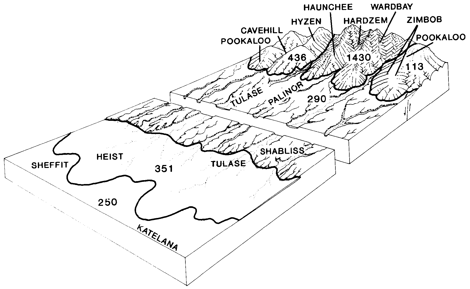
Pookaloo-Cavehill-Hyzen association | 6436 | 1724 | 2215613 | 2t6h3 | nv778 | 2013 | 1:24000 |
Onkeyo-Pookaloo-Adobe association | 6850 | 1514 | 2215817 | 2dcqz | nv778 | 2013 | 1:24000 |
Pookaloo-Urmafot-Tulase association | 6437 | 420 | 2215796 | 2dcq9 | nv778 | 2013 | 1:24000 |
Pookaloo-Cavehill-Rock outcrop association | 1170 | 13469 | 479942 | 2t6gm | nv779 | 2004 | 1:24000 |
Pookaloo-Cavehill-Lodar association | 1140 | 4884 | 479937 | j3dv | nv779 | 2004 | 1:24000 |
Tecomar-Pookaloo association | 1010 | 3233 | 479920 | j3d9 | nv779 | 2004 | 1:24000 |
Tecomar-Pookaloo-Cavehill association | 1011 | 2511 | 479921 | j3db | nv779 | 2004 | 1:24000 |
Pookaloo-Zimbob-Hyzen association | 1142 | 2253 | 637437 | pd9h | nv779 | 2004 | 1:24000 |
Tecomar-Tecomar, dry-Pookaloo association | 67 | 1425 | 2633960 | 2rhgj | nv779 | 2004 | 1:24000 |
Pookaloo-Tecomar-Cavehill association | 1139 | 1120 | 2817238 | 2tzh8 | nv779 | 2004 | 1:24000 |
Pookaloo-Tecomar-Rock outcrop association MLRA 28B | 1141 | 938 | 637438 | 2t6gk | nv779 | 2004 | 1:24000 |
Tecomar-Zimbob-Pookaloo association | 1144 | 551 | 2817239 | 2tzh9 | nv779 | 2004 | 1:24000 |
Hyzen-Pookaloo-Tecomer association | 6201 | 367 | 2817248 | 2tzhp | nv779 | 2004 | 1:24000 |
Pookaloo-Urmafot-Tulase association | 1143 | 210 | 637436 | pd9g | nv779 | 2004 | 1:24000 |
Mijoysee-Pookaloo-Tecomar association | 5040 | 60 | 637444 | 2tzhy | nv779 | 2004 | 1:24000 |
Pookaloo-Cavehill association | 1138 | 9 | 2817237 | 2tzh6 | nv779 | 2004 | 1:24000 |
Pookaloo-Cavehill-Rock outcrop association | 100 | 218255 | 480132 | 2t6gm | nv780 | 1990 | 1:24000 |
Zimbob-Pookaloo association | 977 | 76058 | 2634092 | 2rn40 | nv780 | 1990 | 1:24000 |
Pookaloo-Hyzen-Mijoysee association | 434 | 47409 | 480476 | j3z7 | nv780 | 1990 | 1:24000 |
Pookaloo-Cavehill-Hyzen association | 436 | 26146 | 480478 | 2t6h3 | nv780 | 1990 | 1:24000 |
Pookaloo-Tecomar-Rock outcrop association MLRA 28B | 108 | 25265 | 480152 | 2t6gk | nv780 | 1990 | 1:24000 |
Tecomar-Pookaloo association | 124 | 20267 | 480204 | 2t6x2 | nv780 | 1990 | 1:24000 |
Mijoysee-Pookaloo-Tecomar association | 201 | 14691 | 480341 | j3tw | nv780 | 1990 | 1:24000 |
Pookaloo-Tecomer-Cavehill associatiom | 1142 | 13611 | 2817255 | 2tzj0 | nv780 | 1990 | 1:24000 |
Pookaloo-Urmafot-Tulase association | 437 | 11762 | 480479 | j3zb | nv780 | 1990 | 1:24000 |
Tecomar-Xine-Pookaloo association | 126 | 10860 | 480215 | j3pt | nv780 | 1990 | 1:24000 |
Tecomar-Pookaloo-Zimbob association | 120 | 10626 | 480193 | j3p3 | nv780 | 1990 | 1:24000 |
Amelar-Pookaloo-Tulase association | 874 | 8115 | 480625 | j441 | nv780 | 1990 | 1:24000 |
Upatad-Pookaloo association | 751 | 8080 | 480581 | j42m | nv780 | 1990 | 1:24000 |
Pookaloo-Onkeyo-Cavehill association | 1800 | 6455 | 480319 | j3t5 | nv780 | 1990 | 1:24000 |
Tecomer-Zimbob-Pookaloo association | 1144 | 5359 | 2817256 | 2tzj1 | nv780 | 1990 | 1:24000 |
Pookaloo-Zimbob-Hyzen association | 104 | 4915 | 480145 | j3mk | nv780 | 1990 | 1:24000 |
Onkeyo-Pookaloo-Adobe association | 850 | 4156 | 480617 | j43s | nv780 | 1990 | 1:24000 |
Urmafot-Cavehill-Pookaloo association | 1288 | 3910 | 480227 | j3q6 | nv780 | 1990 | 1:24000 |
Urmafot-Tecomar-Pookaloo association | 328 | 3565 | 480424 | j3xk | nv780 | 1990 | 1:24000 |
Hutchley-McIvey-Pookaloo association | 223 | 3100 | 480351 | j3v6 | nv780 | 1990 | 1:24000 |
Onkeyo-Cavehill-Pookaloo association | 510 | 2695 | 480509 | j409 | nv780 | 1990 | 1:24000 |
Tecomar-Pookaloo-Zimbob association | 6120 | 181 | 2817283 | 2whnf | nv783 | 1991 | 1:24000 |
Zimbob-Pookaloo-Cavehill association | 1291 | 15310 | 481156 | j4p5 | nv784 | 2006 | 1:24000 |
Pookaloo-Cavehill-Rock outcrop association | 1190 | 12745 | 481142 | 2t6gm | nv784 | 2006 | 1:24000 |