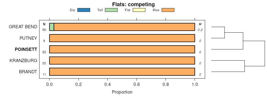
| Poinsett-Buse complex, 2 to 6 percent slopes | 741B | 6878 | 430338 | gfsw | mn073 | 1994 | 1:20000 |
Poinsett-Waubay silty clay loams, 1 to 6 percent slopes | 284B | 3892 | 430279 | 2rkz3 | mn073 | 1994 | 1:20000 |
Poinsett-Waubay silty clay loams, 1 to 6 percent slopes | J195B | 3566 | 1480088 | 2rkz3 | mn081 | 2007 | 1:12000 |
Rusklyn-Poinsett complex, 6 to 12 percent slopes, moderately eroded | J198C2 | 580 | 1480089 | 1lp4t | mn081 | 2007 | 1:12000 |
Poinsett-Waubay silty clay loams, 1 to 6 percent slopes | J195B | 3709 | 1486210 | 2rkz3 | mn083 | 2008 | 1:12000 |
Rusklyn-Poinsett complex, 6 to 12 percent slopes, moderately eroded | J198C2 | 505 | 1486211 | 1lwj9 | mn083 | 2008 | 1:12000 |
Poinsett-Waubay silty clay loams, 1 to 6 percent slopes | J195B | 4716 | 1481652 | 2rkz3 | mn101 | 2008 | 1:12000 |
Poinsett-Waubay silty clay loams, 1 to 6 percent slopes | J195B | 531 | 1481707 | 2rkz3 | mn173 | 1979 | 1:20000 |
Rusklyn-Poinsett complex, 6 to 12 percent slopes, moderately eroded | J198C2 | 231 | 1653939 | 1sj1w | mn173 | 1979 | 1:20000 |
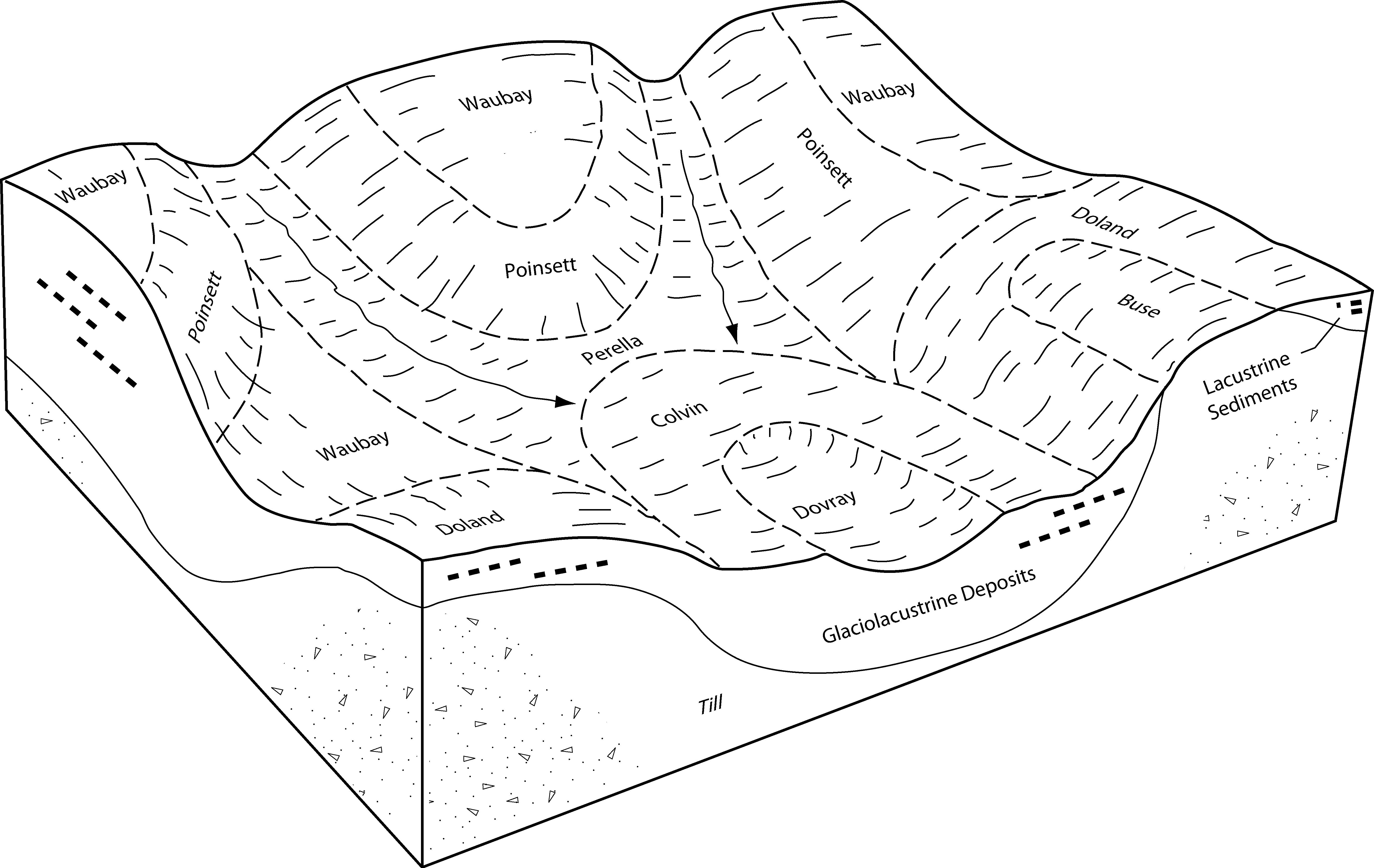
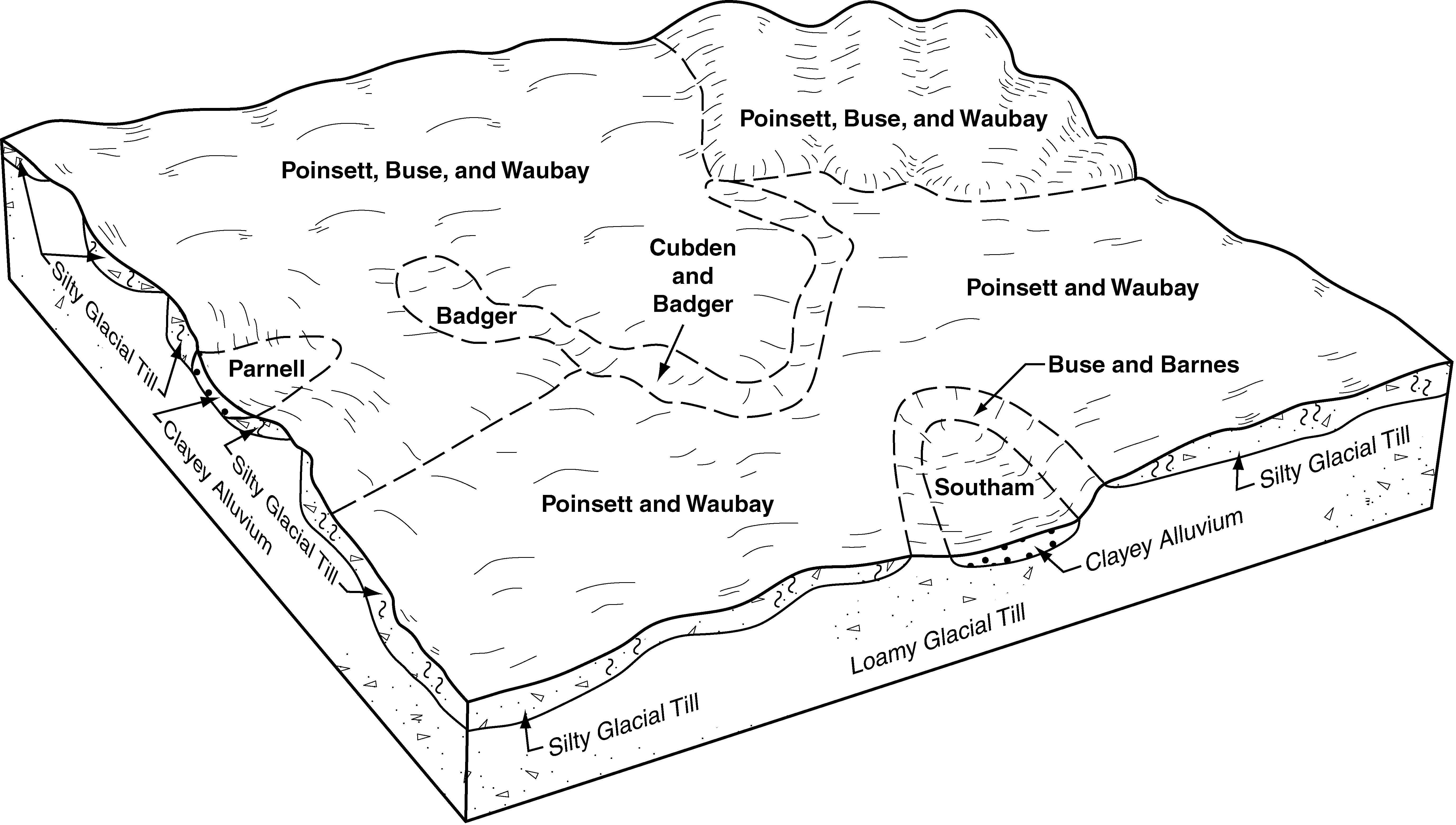
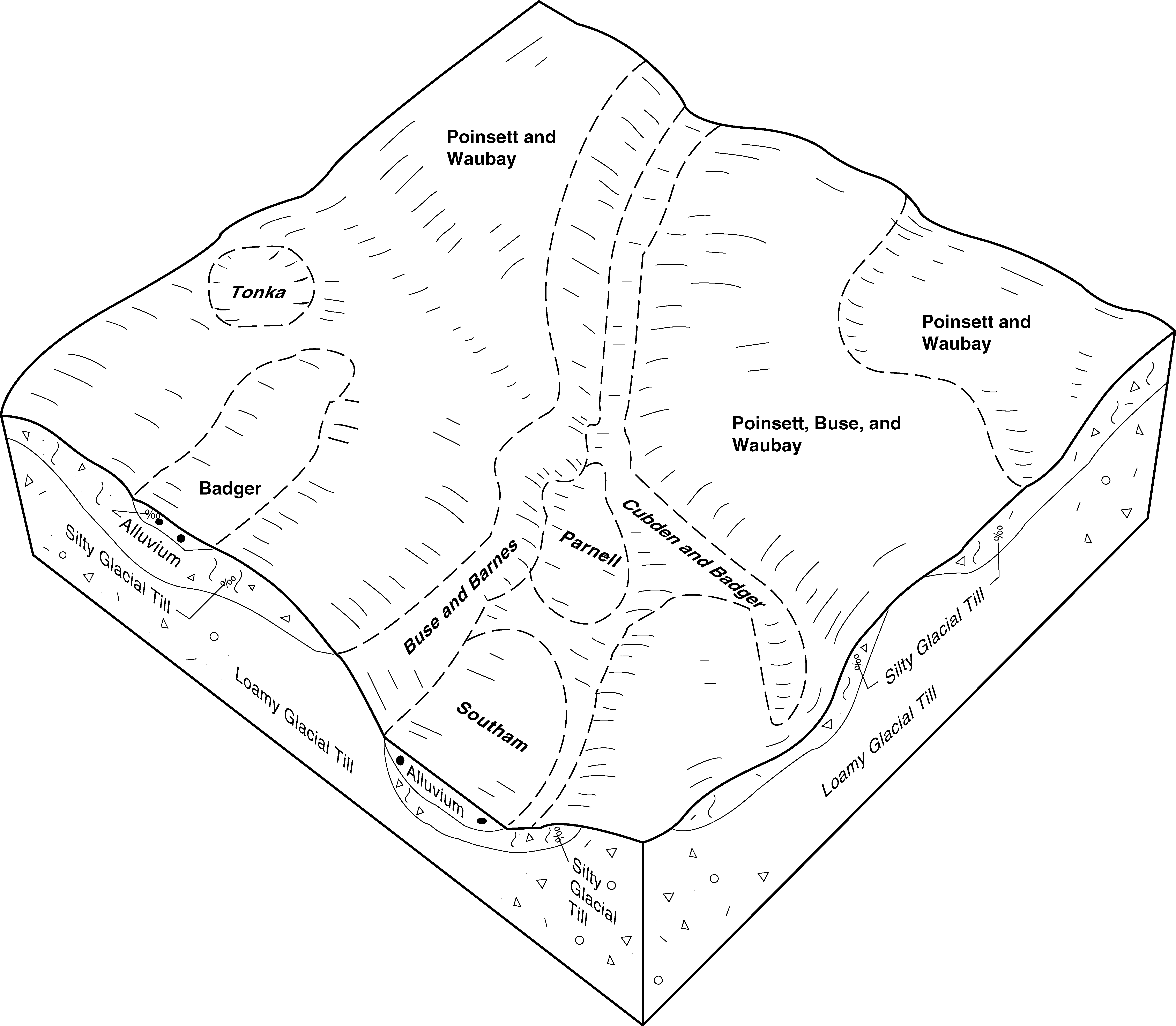
Poinsett-Buse-Waubay complex, 1 to 6 percent slopes | PbB | 37143 | 418792 | 2tlc8 | sd011 | 1995 | 1:24000 |
Poinsett-Buse-Waubay complex, 2 to 9 percent slopes | PbC | 24931 | 418793 | 2tlc9 | sd011 | 1995 | 1:24000 |
Poinsett-Waubay silty clay loams, 1 to 6 percent slopes | PwB | 13163 | 418795 | 2rkz3 | sd011 | 1995 | 1:24000 |
Buse-Poinsett complex, 9 to 15 percent slopes | BpD | 5537 | 418731 | g1qg | sd011 | 1995 | 1:24000 |
Poinsett-Waubay silty clay loams, 0 to 2 percent slopes | PwA | 3522 | 418794 | 2t5qv | sd011 | 1995 | 1:24000 |
Buse, very stony-Poinsett complex, 9 to 25 percent slopes | BrD | 1423 | 418732 | g1qh | sd011 | 1995 | 1:24000 |
Poinsett-Waubay silty clay loams, 1 to 6 percent slopes | PwB | 43781 | 417777 | 2rkz3 | sd025 | 1992 | 1:20000 |
Poinsett-Rusklyn-Waubay silty clay loams, 1 to 6 percent slopes | PrB | 32104 | 417775 | 2rkz5 | sd025 | 1992 | 1:20000 |
Poinsett-Waubay silty clay loams, 0 to 2 percent slopes | PwA | 16501 | 417776 | 2t5qv | sd025 | 1992 | 1:20000 |
Poinsett-Rusklyn silty clay loams, 6 to 9 percent slopes | PoC | 7071 | 417774 | g0ql | sd025 | 1992 | 1:20000 |
Poinsett-Buse-Waubay complex, 1 to 6 percent slopes | PnB | 4031 | 417772 | 2tlc8 | sd025 | 1992 | 1:20000 |
Poinsett-Buse-Waubay complex, 2 to 9 percent slopes | PnC | 417 | 417773 | 2tlc9 | sd025 | 1992 | 1:20000 |
Poinsett-Waubay silty clay loams, 0 to 2 percent slopes | G794A | 95 | 2798029 | 2sd5z | sd025 | 1992 | 1:20000 |
Poinsett-Buse-Waubay complex, 1 to 6 percent slopes | J162B | 53951 | 1684296 | 2tlc8 | sd029 | 2006 | 1:12000 |
Poinsett-Waubay silty clay loams, 0 to 2 percent slopes | J164A | 10524 | 1684294 | 2t5qv | sd029 | 2006 | 1:12000 |
Poinsett-Buse-Waubay complex, 2 to 9 percent slopes | J162C | 7656 | 1684304 | 2tlc9 | sd029 | 2006 | 1:12000 |
Poinsett-Waubay silty clay loams, 1 to 6 percent slopes | J164B | 4351 | 1684295 | 2rkz3 | sd029 | 2006 | 1:12000 |
Poinsett-Rusklyn-Waubay silty clay loams, 1 to 6 percent slopes | J163B | 3223 | 1684307 | 2rkz5 | sd029 | 2006 | 1:12000 |
Buse-Poinsett complex, 6 to 9 percent slopes | J118C | 1623 | 1684305 | 1tjnf | sd029 | 2006 | 1:12000 |
Poinsett-Rusklyn-Waubay silty clay loams, 1 to 6 percent slopes | PsB | 17853 | 417120 | 2rkz5 | sd037 | 1992 | 1:20000 |
Poinsett-Waubay silty clay loams, 1 to 6 percent slopes | PwB | 13486 | 417122 | 2rkz3 | sd037 | 1992 | 1:20000 |
Poinsett-Waubay silty clay loams, 0 to 2 percent slopes | PwA | 5434 | 417121 | 2t5qv | sd037 | 1992 | 1:20000 |
Poinsett-Rusklyn silty clay loams, 6 to 9 percent slopes | PrC | 2045 | 417119 | g01g | sd037 | 1992 | 1:20000 |
Poinsett-Buse-Waubay complex, 1 to 6 percent slopes | PnB | 1189 | 800062 | 2tlc8 | sd037 | 1992 | 1:20000 |
Poinsett-Waubay silty clay loams, 1 to 6 percent slopes | PwB | 8024 | 416892 | 2rkz3 | sd039 | 1992 | 1:20000 |
Poinsett-Waubay silty clay loams, 0 to 2 percent slopes | PwA | 5618 | 416891 | 2t5qv | sd039 | 1992 | 1:20000 |
Poinsett silty clay loam, 6 to 9 percent slopes | PoC | 677 | 416890 | fzt2 | sd039 | 1992 | 1:20000 |
Poinsett-Waubay silty clay loams, 0 to 2 percent slopes | Po | 1522 | 418178 | 2t5qv | sd051 | 1977 | 1:20000 |
Poinsett-Buse-Waubay complex, 1 to 6 percent slopes | PsB | 62101 | 417302 | 2tlc8 | sd057 | 1992 | 1:20000 |
Poinsett-Waubay silty clay loams, 1 to 6 percent slopes | PwB | 47492 | 417305 | 2rkz3 | sd057 | 1992 | 1:20000 |
Poinsett-Waubay silty clay loams, 0 to 2 percent slopes | PwA | 13419 | 417304 | 2t5qv | sd057 | 1992 | 1:20000 |
Poinsett-Buse-Waubay complex, 2 to 9 percent slopes | PsC | 8225 | 417303 | 2tlc9 | sd057 | 1992 | 1:20000 |
Buse-Poinsett complex, 6 to 9 percent slopes | ByC | 7887 | 417264 | g064 | sd057 | 1992 | 1:20000 |
Buse-Poinsett complex, 9 to 15 percent slopes | ByD | 1742 | 417265 | g065 | sd057 | 1992 | 1:20000 |
Poinsett-Buse-Waubay complex, 1 to 6 percent slopes | PoB | 74479 | 417503 | 2tlc8 | sd077 | 1992 | 1:20000 |
Poinsett-Waubay silty clay loams, 1 to 6 percent slopes | PwB | 48078 | 417507 | 2rkz3 | sd077 | 1992 | 1:20000 |
Poinsett-Buse-Waubay complex, 2 to 9 percent slopes | PoC | 20766 | 417504 | 2tlc9 | sd077 | 1992 | 1:20000 |
Poinsett-Waubay silty clay loams, 0 to 2 percent slopes | PwA | 12715 | 417506 | 2t5qv | sd077 | 1992 | 1:20000 |
Poinsett-Rusklyn-Waubay silty clay loams, 1 to 6 percent slopes | PrB | 1862 | 417505 | 2rkz5 | sd077 | 1992 | 1:20000 |
Poinsett-Forman complex, 2 to 6 percent slopes | PoB | 9286 | 416595 | 30t28 | sd091 | 1970 | 1:20000 |
Forman-Poinsett complex, 6 to 9 percent slopes | FxC | 9023 | 416563 | 30t26 | sd091 | 1970 | 1:20000 |
Forman-Poinsett complex, 9 to 15 percent slopes | FxD | 8407 | 416564 | 30t27 | sd091 | 1970 | 1:20000 |
Poinsett-Forman complex, 2 to 6 percent slopes | G791B | 5685 | 2799377 | 2sd5t | sd091 | 1970 | 1:20000 |
Poinsett-Waubay silty clay loams, 1 to 6 percent slopes | PwB | 2774 | 416597 | 2rkz3 | sd091 | 1970 | 1:20000 |
Forman-Poinsett complex, 6 to 9 percent slopes | G791C | 2679 | 2799378 | 2sd5v | sd091 | 1970 | 1:20000 |
Forman-Poinsett complex, 9 to 15 percent slopes | G791D | 1304 | 2799379 | 2sd5w | sd091 | 1970 | 1:20000 |
Poinsett-Waubay silty clay loams, 0 to 2 percent slopes | PwA | 724 | 416596 | 2t5qv | sd091 | 1970 | 1:20000 |
Poinsett-Waubay silty clay loams, 0 to 2 percent slopes | G794A | 396 | 2799381 | 2sd5z | sd091 | 1970 | 1:20000 |
Poinsett-Waubay silty clay loams, 0 to 2 percent slopes | PoA | 11674 | 417859 | 2t5qv | sd109 | 1977 | 1:20000 |
Poinsett-Waubay silty clay loams, 1 to 6 percent slopes | PoB | 6645 | 417860 | 2rkz3 | sd109 | 1977 | 1:20000 |
