| Plummer loamy sand, 0 to 5 percent slopes | PmB | 35533 | 328189 | c0hr | al003 | 1961 | 1:20000 |
Plummer loamy sand, 5 to 12 percent slopes | PmC | 1805 | 328190 | c0hs | al003 | 1961 | 1:20000 |
Rains and Plummer soils, level | RaA | 1055 | 329013 | c1cb | al045 | 1958 | 1:20000 |
Rains and Plummer soils, 5 to 20 percent slopes | RaD | 351 | 329014 | c1cc | al045 | 1958 | 1:20000 |
Plummer loamy sand, 0 to 5 percent slopes (albany) | PlB | 8881 | 329352 | c1q8 | al053 | 1969 | 1:20000 |
Plummer loamy sand, 5 to 12 percent slopes | PlC | 7947 | 329353 | c1q9 | al053 | 1969 | 1:20000 |
Plummer loamy sand | Pm | 4070 | 329636 | c20f | al061 | 1973 | 1:20000 |
Plummer sand, 0 to 2 percent slopes | PmA | 3794 | 608042 | ndq8 | al069 | 2002 | 1:24000 |
Plummer fine sand | 51 | 5709 | 320746 | brrn | fl001 | 1982 | 1:15840 |
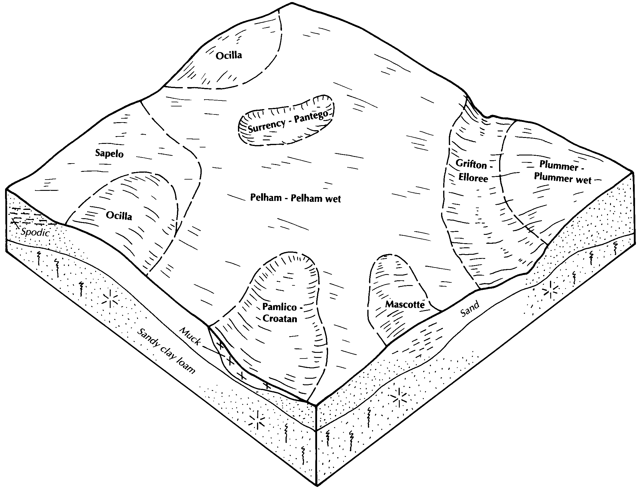
Pelham, Plummer, and Mascotte soils, occasionally flooded | 82 | 3200 | 320788 | brt0 | fl001 | 1982 | 1:15840 |
Plummer fine sand | 39 | 4440 | 1444897 | 1khjl | fl003 | 1991 | 1:20000 |
Plummer sand | 32 | 17337 | 320821 | brv2 | fl005 | 1982 | 1:20000 |
Plummer-Plummer wet, sands | 6 | 12483 | 631618 | p67s | fl007 | 1988 | 1:15840 |
Plummer sand, 0 to 5 percent slopes | 51 | 9559 | 1481036 | 1lq4c | fl013 | 1997 | 1:20000 |
Plummer fine sand | 17 | 2485 | 132807 | 4g63 | fl019 | 1986 | 1:24000 |
Plummer fine sand, depressional | 46 | 1180 | 132834 | 4g6z | fl019 | 1986 | 1:24000 |
Plummer, depressional-Pamlico, loamy substratum complex | 55 | 28470 | 797478 | vrv3 | fl023 | 1981 | 1:24000 |
Plummer fine sand | 51 | 9880 | 797474 | vrtz | fl023 | 1981 | 1:24000 |
Plummer fine sand, occasionally flooded | 53 | 9860 | 797476 | vrv1 | fl023 | 1981 | 1:24000 |
Plummer muck, depressional | 54 | 9440 | 797477 | vrv2 | fl023 | 1981 | 1:24000 |
Plummer fine sand, depressional | 52 | 2900 | 797475 | vrv0 | fl023 | 1981 | 1:24000 |
Plummer fine sand | 28 | 27176 | 1477080 | 1ll0r | fl037 | 1990 | 1:20000 |
Plummer sand, 0 to 5 percent slopes | 51 | 4490 | 1381591 | 1hcng | fl039 | 2006 | 1:12000 |
Plummer-Leon-Sapelo complex | 106 | 869 | 1472129 | 1ldw1 | fl039 | 2006 | 1:12000 |
Hosford and Plummer mucky sands, 2 to 12 percent slopes | 90 | 777 | 1381629 | 1hcpp | fl039 | 2006 | 1:12000 |
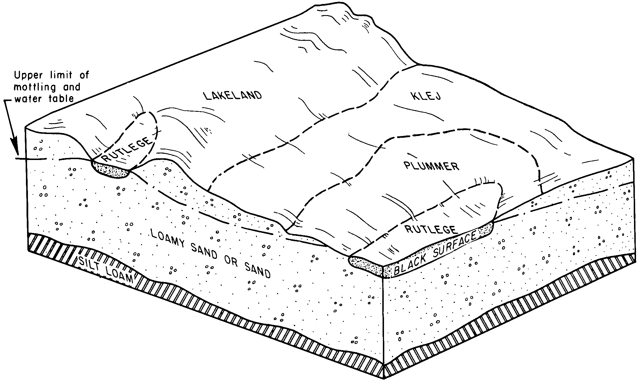
Rutlege and Plummer soils, depressional | 98 | 465 | 1408322 | 1j8gr | fl039 | 2006 | 1:12000 |
Plummer fine sand | 28 | 37618 | 1472749 | 1lfj1 | fl045 | 1997 | 1:24000 |
Plummer and Surrency soils, depressional | 21 | 25450 | 1148817 | 17kfm | fl047 | 1995 | 1:24000 |
Plummer sand | 34 | 13070 | 1148831 | 17kg2 | fl047 | 1995 | 1:24000 |
Mascotte and Plummer soils, occasionally flooded | 26 | 8770 | 1148822 | 17kfs | fl047 | 1995 | 1:24000 |
Plummer fine sand | 26 | 740 | 1017259 | 134jt | fl059 | 1971 | 1:12000 |
Plummer sand, depressional | 52 | 5200 | 1424958 | 1jtsd | fl063 | 1977 | 1:20000 |
Plummer sand | 51 | 4250 | 1424957 | 1jtsc | fl063 | 1977 | 1:20000 |
Plummer fine sand | 22 | 20851 | 700485 | rhx9 | fl065 | 1984 | 1:20000 |
Plummer fine sand, frequently flooded | 45 | 6060 | 700504 | rhxx | fl065 | 1984 | 1:20000 |
Surrency, Plummer, and Clara soils, depressional | 18 | 5300 | 886573 | yrk4 | fl067 | 1993 | 1:24000 |
Plummer fine sand | 20 | 360 | 886575 | yrk6 | fl067 | 1993 | 1:24000 |
Plummer fine sand | 41 | 20425 | 1454451 | 1ktgs | fl073 | 1989 | 1:20000 |
Plummer mucky fine sand, depressional | 42 | 1470 | 1454452 | 1ktgt | fl073 | 1989 | 1:20000 |
Rutlege and Plummer soils, frequently ponded, 0 to 1 percent slopes | 12 | 67210 | 322698 | 2ttm2 | fl077 | 2004 | 1:24000 |
Plummer, Sapelo and Pottsburg sand, 0 to 2 percent slopes | 83 | 61470 | 322768 | 2xnr9 | fl077 | 2004 | 1:24000 |
Plummer and Pelham soils | 32 | 11375 | 322720 | bttb | fl077 | 2004 | 1:24000 |
Plummer sand, 0 to 5 percent slopes | 55 | 5900 | 322745 | btv4 | fl077 | 2004 | 1:24000 |
Plummer and Surrency soils, depressional | 48 | 41760 | 1380318 | 1hbbd | fl079 | 1988 | 1:15840 |
Plummer sand | 23 | 28220 | 1380310 | 1hbb4 | fl079 | 1988 | 1:15840 |
Surrency, Plummer, and Cantey soils, frequently flooded | 77 | 7310 | 1380343 | 1hbc6 | fl079 | 1988 | 1:15840 |
Sapelo-Mascotte-Plummer complex | 49 | 4750 | 1023363 | 13bwq | fl121 | 2003 | 1:24000 |
Surrency, Plummer, and Cantey soils, frequently flooded | 74 | 965 | 1023388 | 13bxj | fl121 | 2003 | 1:24000 |
Plummer fine sand, depressional | 52 | 689 | 1023366 | 13bwt | fl121 | 2003 | 1:24000 |
Plummer fine sand | 51 | 656 | 1023365 | 13bws | fl121 | 2003 | 1:24000 |
Mascotte and Plummer soils, occasionally flooded | 68 | 479 | 1023382 | 13bxb | fl121 | 2003 | 1:24000 |
Plummer muck, depressional | 54 | 167 | 1023368 | 13bww | fl121 | 2003 | 1:24000 |
Plummer-Plummer, wet, fine sands, 0 to 2 percent slopes | 27 | 5790 | 1425221 | 2tsyd | fl123 | 1998 | 1:24000 |
Plummer-Plummer wet, sands | 6 | 20800 | 1414611 | 1jh0m | fl125 | 1989 | 1:15840 |
Plummer-Plummer, wet, fine sands, 0 to 2 percent slopes | 32 | 6370 | 1399059 | 2tsyd | fl129 | 1988 | 1:24000 |
Clara and Plummer soils, occasionally ponded | 87 | 6540 | 2398484 | 2lhtg | fl133 | 2009 | 1:12000 |
Plummer sand | PeA | 8540 | 324552 | bwqf | ga031 | 1965 | 1:20000 |
Plummer sand, 0 to 2 percent slopes | PeA | 955 | 324822 | bx04 | ga165 | 1966 | 1:20000 |
Plummer sands | PeA | 1920 | 124646 | 45pv | ga191 | 1960 | 1:20000 |
Plummer sand, 0 to 2 percent slopes | PeA | 4550 | 324989 | bx5j | ga283 | 1962 | 1:20000 |
Plummer sand, 2 to 5 percent slopes | PeB | 1380 | 324990 | bx5k | ga283 | 1962 | 1:20000 |
Plummer soils | PeA | 64365 | 125101 | 465j | ga305 | 1962 | 1:20000 |
Plummer sand, 0 to 3 percent slopes | PeA | 32800 | 325213 | bxdr | ga608 | 1965 | 1:20000 |
Plummer loamy sand, 0 to 2 percent slopes | PlA | 533 | 2642226 | 2rs32 | ms041 | 2012 | 1:24000 |
Plummer loamy sand | Pe | 2630 | 332402 | c4wn | ms045 | 1979 | 1:20000 |
Plummer loamy sand | Pm | 10106 | 332440 | c4xw | ms047 | 1971 | 1:20000 |
Osier loamy sand, loamy substratum (Plummer) | Os | 4043 | 114339 | 3tzc | nc147 | 1969 | 1:15840 |
Plummer and Osier soils | Pm | 5982 | 114785 | 3vfr | nc155 | 1972 | 1:20000 |
Plummer and Osier soils, 0 to 2 percent slopes | PuA | 2626 | 1480499 | 1lpl1 | nc165 | 2006 | 1:12000 |
Plummer sandy loam, very wet, 0 to 2 percent slopes | PmmwA | 1047 | 1403682 | 1j3n2 | nj021 | 1969 | 1:24000 |
Plummer sandy loam, 0 to 2 percent slopes | PmmA | 963 | 1413854 | 1jg76 | nj021 | 1969 | 1:24000 |
Plummer loamy sand, 0 to 2 percent slopes | PmA | 5245 | 138101 | 4mpw | sc009 | 1997 | 1:24000 |
Plummer loamy sand | 53 | 6783 | 132289 | 4fnd | sc029 | 1980 | 1:20000 |
Plummer loamy sand | Pm | 2200 | 129823 | 4c2v | sc035 | 1985 | 1:20000 |
Plummer loamy fine sand | Pm | 2427 | 130124 | 4cdk | sc049 | 1990 | 1:20000 |
Plummer loamy sand | Pu | 3697 | 1151497 | 17n72 | sc665 | 1973 | 1:24000 |
