| Dryvalley-Playas complex, 0 to 2 percent slopes | 183 | 13935 | 487458 | jc7g | ca608 | 2000 | 1:24000 |
Epot-Playas complex, 0 to 2 percent slopes | 192 | 13130 | 487473 | jc7y | ca608 | 2000 | 1:24000 |
Termo-Playas complex, 0 to 1 percent slopes | 380 | 9808 | 487740 | jcjk | ca608 | 2000 | 1:24000 |
Epot-Ragtown-Playas complex, 0 to 2 percent slopes | 193 | 9692 | 487474 | jc7z | ca608 | 2000 | 1:24000 |
Biscaro-Playas complex, 0 to 2 percent slopes | 119 | 3932 | 487351 | jc40 | ca608 | 2000 | 1:24000 |
Hagata-Playas complex, 0 to 2 percent slopes | 231 | 3100 | 487525 | jc9m | ca608 | 2000 | 1:24000 |
Calneva-Playas complex, 0 to 1 percent slopes | 141 | 1111 | 487389 | jc57 | ca608 | 2000 | 1:24000 |
Wespac-Playas complex, 0 to 2 percent slopes | 397 | 1097 | 487764 | jckb | ca608 | 2000 | 1:24000 |
Playas | 326 | 511 | 487660 | jcfz | ca608 | 2000 | 1:24000 |
Playas | Py | 2419 | 456899 | hbfp | ca638 | 1967 | 1:24000 |
Playas | Pl | 1942 | 464406 | hl7v | ca654 | 1966 | 1:24000 |
Playas ponded | 910 | 3685 | 458524 | hd43 | ca667 | 2003 | 1:24000 |
Playas | 911 | 2745 | 458525 | hd44 | ca667 | 2003 | 1:24000 |
Playas | 158 | 811 | 463862 | hkp9 | ca670 | 1977 | 1:24000 |
PLAYAS | 156 | 19500 | 463975 | hksy | ca671 | 1978 | 1:24000 |
Playas | 527 | 15077 | 1675863 | 1t7w3 | ca685 | 2006 | 1:24000 |
Playas | 376 | 6569 | 471489 | htmb | ca732 | 1998 | 1:24000 |
Playas | 283 | 66737 | 488233 | jd1g | ca802 | 1996 | 1:24000 |
Playa | 4820 | 4 | 1860762 | 20g8l | ca805 | 2012 | 1:24000 |
Intermittent water | IW | 988 | 822617 | wm01 | co001 | 1968 | 1:20000 |
Intermittent Water | IW | 443 | 995820 | 12f77 | co005 | 1971 | 1:20000 |
Playa | PLY | 1570 | 695309 | rbjb | co009 | 1966 | 1:20000 |
Playas | 29 | 9170 | 94438 | 358d | co061 | 1977 | 1:24000 |
Playas | PLY | 422 | 2992071 | qsnn | co099 | 1963 | 1:15840 |
Playas | 86 | 2271 | 95098 | 35yp | co617 | 1980 | 1:24000 |
Playas | 84 | 658 | 95185 | 361h | co618 | 1976 | 1:24000 |
Playas | IW | 53 | 886509 | yrh2 | co622 | 1968 | 1:20000 |
Playas | 46 | 68 | 1408131 | 1j88l | co623 | 1977 | 1:24000 |
Playas | PLY | 1749 | 95270 | 3647 | co624 | 1963 | 1:20000 |
Playas | 60 | 268 | 498636 | jqw1 | co630 | 1975 | 1:24000 |
Playas | PLY | 37 | 512286 | k62c | co643 | 1975 | 1:20000 |
Playas | 137 | 198 | 497755 | jpym | co644 | 1980 | 1:24000 |
Playas | PLY | 383 | 497830 | jq11 | co646 | 1973 | 1:24000 |
Playas, 0 to 1 percent slopes | 9907 | 20 | 2519302 | 2prj2 | id001 | 2012 | 1:24000 |
Playas | PLA | 80 | 80892 | 2q5f | id665 | 1967 | 1:20000 |
Playas-Duric Natrargids association, nearly level | 133 | 1382 | 485958 | j9p2 | id675 | 1992 | 1:24000 |
Farmell-Power-Playas complex, 0 to 2 percent slopes | 54 | 4665 | 82076 | 2rdm | id681 | 1993 | 1:24000 |
Playas | 146 | 150 | 81877 | 2r66 | id681 | 1993 | 1:24000 |
Playas, 0 to 1 percent slopes | 9907 | 70 | 2519649 | 2prj2 | id685 | 2012 | 1:24000 |
Playas, 0 to 1 percent slopes | 88 | 1155 | 79110 | 2n9y | id763 | 1998 | 1:24000 |
Farmell-Power-Playas complex, 0 to 2 percent slopes | 16 | 23 | 1487045 | 1lxd6 | id780 | 1998 | 1:24000 |
Playas | 54 | 13 | 1531746 | 1ndx5 | id780 | 1998 | 1:24000 |
Playas | PL | 749 | 146901 | 4xvr | mt600 | 1969 | 1:24000 |
Playas, saline, 0 to 1 percent slopes, frequently ponded | Pb | 2427 | 376457 | dmqs | nm025 | 1967 | 1:20000 |
Playas, salt lake, occasionally ponded | SL | 3283 | 1607338 | f5t9 | nm041 | 2014 | 1:24000 |
Playas | PY | 17437 | 1474003 | 1lgth | nm674 | 1965 | 1:24000 |
Dune land-Playas complex | 139 | 12982 | 643803 | plxv | nv603 | 1971 | 1:24000 |
Appian-Playas association | 108 | 12036 | 643772 | plwv | nv603 | 1971 | 1:24000 |
Churchill-Playas complex, 0 to 2 percent slopes | 131 | 8506 | 643795 | plxl | nv603 | 1971 | 1:24000 |
Playas | PL | 1424 | 469395 | hrfs | nv608 | 1967 | 1:24000 |
Kawich-Playas complex | Kp | 11498 | 491533 | jhgx | nv611 | 1967 | 1:24000 |
Dune land, clayey-Playas association | Cd | 1089 | 491505 | jhg0 | nv611 | 1967 | 1:24000 |
Ocala-Ocala-Playas association | OP | 4385 | 476117 | hzfm | nv612 | 1968 | 1:24000 |
Playas | PL | 28804 | 477958 | j1c0 | nv621 | 1971 | 1:24000 |
Playas-Dianev complex | PS | 20471 | 477959 | j1c1 | nv621 | 1971 | 1:24000 |
Yomba-Playas complex, 0 to 4 percent slopes | Ym | 17539 | 495675 | 2v411 | nv622 | 1972 | 1:24000 |
Playas | PN | 14964 | 495631 | jmr3 | nv622 | 1972 | 1:24000 |
Tipperary-Playas complex | TM | 6201 | 495653 | jmrt | nv622 | 1972 | 1:24000 |
Umberland-Playas complex | UR | 3806 | 495661 | jms2 | nv622 | 1972 | 1:24000 |
Playas-Parran complex | PO | 2496 | 495632 | jmr4 | nv622 | 1972 | 1:24000 |
Timper-Playas complex | TF | 2096 | 495650 | jmrq | nv622 | 1972 | 1:24000 |
Monte Cristo-Playas complex | MO | 2056 | 495600 | jmq3 | nv622 | 1972 | 1:24000 |
Domez-Playas complex | Ds | 981 | 495577 | jmpc | nv622 | 1972 | 1:24000 |
Patna-Hough-Playas association | 517 | 5011 | 473985 | hx6v | nv625 | 1981 | 1:24000 |
Wabuska-Delp-Playas complex, 0 to 15 percent slopes | 725 | 4010 | 474043 | hx8q | nv625 | 1981 | 1:24000 |
Rusty-Playas complex, 0 to 2 percent slopes | 604 | 720 | 474008 | hx7l | nv625 | 1981 | 1:24000 |
Hawsley-Playas complex | 1075 | 699 | 473876 | hx3b | nv625 | 1981 | 1:24000 |
Playas-Hough association | 7094 | 498 | 2425574 | 2mf0b | nv625 | 1981 | 1:24000 |
Dune land-Playas complex | 996 | 5838 | 474430 | hxp6 | nv628 | 1980 | 1:24000 |
Isolde-Playas association | 1342 | 4118 | 474178 | hxf2 | nv628 | 1980 | 1:24000 |
Playas | 2000 | 4401 | 478179 | j1l4 | nv754 | 1992 | 1:24000 |
Ewelac-Playas association | 3193 | 2969 | 1904678 | 21xz7 | nv754 | 1992 | 1:24000 |
Ambush-Panacker-Playas association | 3194 | 655 | 1904679 | 21xz8 | nv754 | 1992 | 1:24000 |
Playa | 4820 | 8020 | 3394092 | 20g8l | nv755 | 2006 | 1:24000 |
Playas | 9901 | 15490 | 474599 | hxvn | nv759 | 1995 | 1:24000 |
Boton-Playas association | 168 | 39136 | 474694 | 2v443 | nv760 | 1994 | 1:24000 |
Playas | 850 | 1990 | 474824 | hy2x | nv760 | 1994 | 1:24000 |
Boton-Playas association | 150 | 3106 | 476259 | 2v443 | nv761 | 1988 | 1:24000 |
Dune land-Playas complex | 161 | 346 | 476262 | hzl9 | nv761 | 1988 | 1:24000 |
Katelana-Zorravista-Playas association | 918 | 17199 | 478528 | j1yd | nv766 | 1994 | 1:24000 |
Benin-Playas association | 103 | 12985 | 478210 | 2v43v | nv766 | 1994 | 1:24000 |
Saltair-Playas association | 161 | 10609 | 478234 | j1mx | nv766 | 1994 | 1:24000 |
Playas, 0 to 1 percent slopes | 760 | 7873 | 478451 | j1vx | nv766 | 1994 | 1:24000 |
Benin, moist-Playas-Benin association | 1241 | 7298 | 478614 | j215 | nv766 | 1994 | 1:24000 |
Orupa-Playas-Boofuss association | 1370 | 6192 | 478631 | j21q | nv766 | 1994 | 1:24000 |
Mazuma-Kawich-Playas association | 804 | 5768 | 478470 | j1wj | nv766 | 1994 | 1:24000 |
Umberland-Playas association | 762 | 5167 | 478453 | j1vz | nv766 | 1994 | 1:24000 |
Playas-Orupa association | 300 | 349 | 2633922 | 2rgpt | nv766 | 1994 | 1:24000 |
Playas | 740 | 12086 | 479303 | j2rd | nv768 | 1985 | 1:63360 |
Cren-Ocala-Playas association | 301 | 2717 | 479169 | j2m2 | nv768 | 1985 | 1:63360 |
Yobe-Isolde-Playas association | 310 | 1513 | 479182 | j2mh | nv768 | 1985 | 1:63360 |
Wendane-Playas association | 1145 | 1473 | 479040 | 2v43p | nv768 | 1985 | 1:63360 |
Playas | 001 | 47066 | 475164 | hyfw | nv769 | 1986 | 1:24000 |
Boton-Playas association | 812 | 3332 | 475314 | 2v443 | nv769 | 1986 | 1:24000 |
Chuckles-Playas complex | 400 | 14130 | 476571 | hzx8 | nv770 | 1995 | 1:24000 |
Bango-Playas-Chuckles association | 222 | 5112 | 476501 | hzv0 | nv770 | 1995 | 1:24000 |
Chuckles-Playas-Slaw association | 402 | 4413 | 476573 | hzxb | nv770 | 1995 | 1:24000 |
Appian-Playas association | 260 | 1607 | 476511 | hzvb | nv770 | 1995 | 1:24000 |
Chuckles-Ragtown-Playas complex | 781 | 11517 | 477560 | j0y5 | nv771 | 1990 | 1:24000 |
Chuckles-Playas complex | 780 | 4181 | 477559 | j0y4 | nv771 | 1990 | 1:24000 |
Tresed-Gitakup-Playas complex | 770 | 3844 | 477558 | j0y3 | nv771 | 1990 | 1:24000 |
Umberland-Playas-Ragtown association | 1445 | 2562 | 477370 | j0r1 | nv771 | 1990 | 1:24000 |
Dune land-Playas complex, 0 to 30 percent slopes | 901 | 371 | 477581 | j0yv | nv771 | 1990 | 1:24000 |
Updike variant-Playas association | 693 | 370 | 644141 | pm8r | nv773 | 1981 | 1:24000 |
Wabuska-Playas-Isolde association | 1141 | 10339 | 476720 | j022 | nv774 | 1985 | 1:24000 |
Playas | 1200 | 6035 | 476732 | j02g | nv774 | 1985 | 1:24000 |
Wabuska-Playas association | 1142 | 5992 | 476721 | j023 | nv774 | 1985 | 1:24000 |
Isolde-Cirac-Playas association | 1043 | 5676 | 476706 | j01m | nv774 | 1985 | 1:24000 |
Playas-Slaw association | 1201 | 4360 | 476733 | 2xdms | nv774 | 1985 | 1:24000 |
Nuyobe-Playas association | 1450 | 3326 | 476776 | j03w | nv774 | 1985 | 1:24000 |
Slaw-Playas association | 1442 | 1769 | 476774 | j03t | nv774 | 1985 | 1:24000 |
Playas-Hough association | 7094 | 588 | 2425599 | 2mf14 | nv774 | 1985 | 1:24000 |
Playas | 740 | 20220 | 479715 | j35p | nv775 | 1985 | 1:24000 |
Wendane-Playas association | 1145 | 7830 | 479418 | 2v43p | nv775 | 1985 | 1:24000 |
Bubus-Playas complex | 243 | 2530 | 479544 | j305 | nv775 | 1985 | 1:24000 |
Wendane-Playas association | 1282 | 490 | 479774 | 2v43p | nv776 | 1983 | 1:63360 |
Playas | 1500 | 393 | 479782 | j37v | nv776 | 1983 | 1:63360 |
Boton-Playas association | 831 | 33786 | 475945 | 2v443 | nv777 | 1993 | 1:24000 |
Playas | 990 | 17083 | 476010 | hzb5 | nv777 | 1993 | 1:24000 |
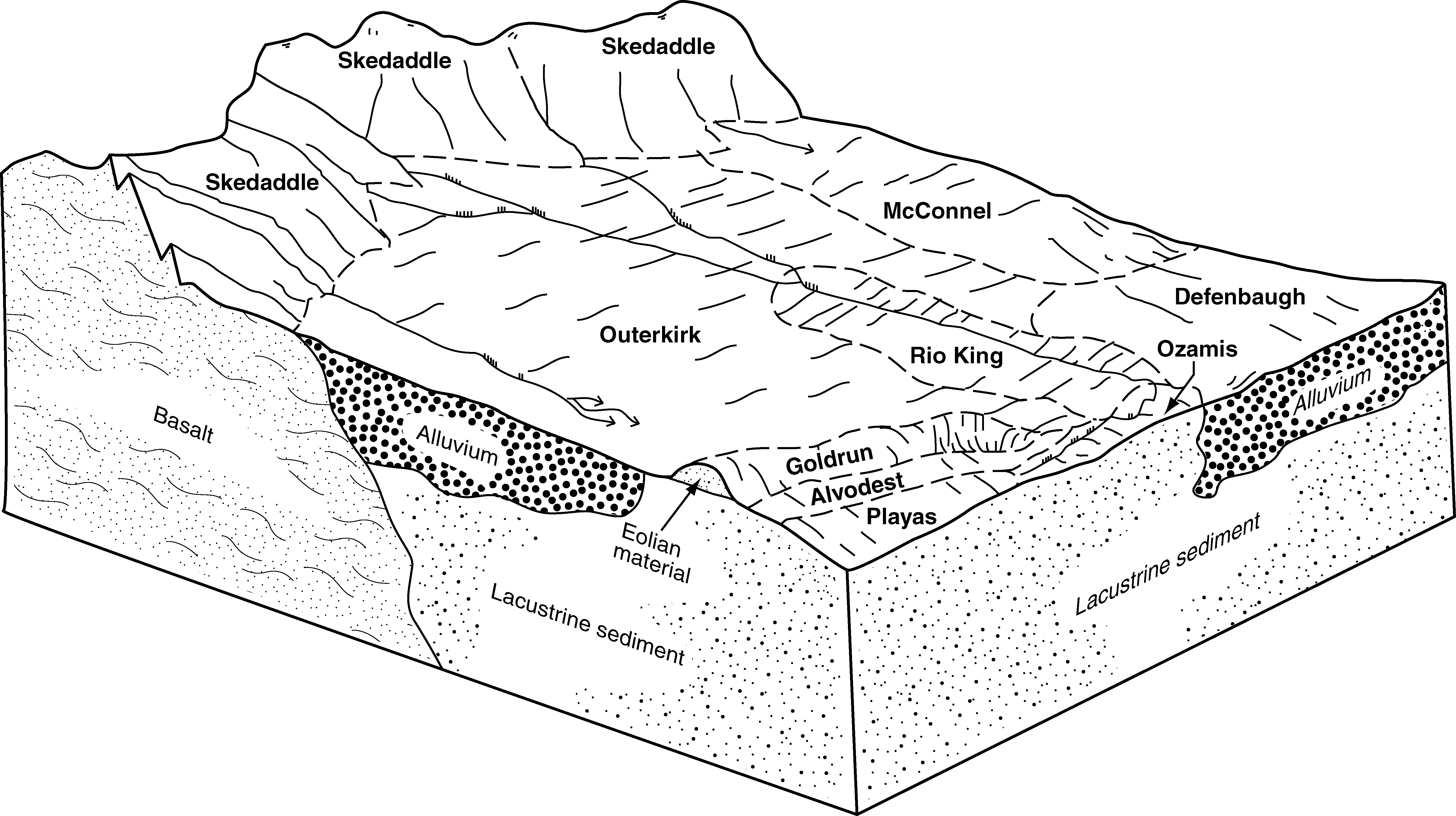
Preble-Goldrun-Playas association | 432 | 15214 | 475726 | hz10 | nv777 | 1993 | 1:24000 |
Cresal-Tresed-Playas complex | 1212 | 5863 | 475454 | hyr7 | nv777 | 1993 | 1:24000 |
Cresal-Playas association | 1210 | 4549 | 475452 | hyr5 | nv777 | 1993 | 1:24000 |
Goldrun-Prideen-Playas complex, 0 to 15 percent slopes | 351 | 4319 | 475696 | hz01 | nv777 | 1993 | 1:24000 |
Essal-Playas-Isolde association | 302 | 4067 | 475673 | hyz9 | nv777 | 1993 | 1:24000 |
Benin-Katelana-Playas association | 3004 | 14750 | 479982 | j3g9 | nv779 | 2004 | 1:24000 |
Playas | 5000 | 6861 | 480131 | j3m3 | nv779 | 2004 | 1:24000 |
Benin-Playas association | 3008 | 4666 | 479985 | j3gd | nv779 | 2004 | 1:24000 |
Dune land, clayey-Playas-Benin association | 3005 | 4192 | 479983 | j3gb | nv779 | 2004 | 1:24000 |
Benin, sodic-Playas association | 3271 | 3147 | 480047 | j3jd | nv779 | 2004 | 1:24000 |
Benin-Sondoa-Playas association | 3270 | 2565 | 480046 | j3jc | nv779 | 2004 | 1:24000 |
Playas-Orupa association | 300 | 29190 | 480414 | j3x7 | nv780 | 1990 | 1:24000 |
Dune land-Playas association | 310 | 995 | 480415 | j3x8 | nv780 | 1990 | 1:24000 |
Yomba-Playas association | 1911 | 50989 | 480832 | 2v412 | nv781 | 1994 | 1:24000 |
Stargo-Playas-Slaw association | 1243 | 10242 | 480718 | j471 | nv781 | 1994 | 1:24000 |
Playas | 1900 | 5626 | 480828 | j4bl | nv781 | 1994 | 1:24000 |
Stargo-Playas complex, 0 to 2 percent slopes | 1242 | 4441 | 480717 | j470 | nv781 | 1994 | 1:24000 |
Wabuska-Playas-Isolde association | 1360 | 775 | 480745 | j47x | nv781 | 1994 | 1:24000 |
Playas-Slaw association | 1901 | 363 | 480829 | 2xdms | nv781 | 1994 | 1:24000 |
Playas | 3900 | 47100 | 481075 | j4lk | nv783 | 1991 | 1:24000 |
Nuyobe-Blueagle-Playas complex, 0 to 30 percent slopes | 3150 | 25824 | 480918 | j4fh | nv783 | 1991 | 1:24000 |
Yomba, loamy surface-Playas complex, 0 to 4 percent slopes | 3911 | 7068 | 481078 | 2v413 | nv783 | 1991 | 1:24000 |
Chuffa-Linoyer-Playas complex | 2071 | 23785 | 481190 | j4q8 | nv784 | 2006 | 1:24000 |
Ewelac-Playas association | 3193 | 4755 | 1454673 | 1ktpy | nv784 | 2006 | 1:24000 |
Ambush-Panacker-Playas association | 3194 | 3695 | 1454672 | 1ktpx | nv784 | 2006 | 1:24000 |
Playas | 2000 | 681 | 481181 | j4pz | nv784 | 2006 | 1:24000 |
Playas | 2900 | 19697 | 469221 | hr85 | nv785 | 1995 | 1:24000 |
Playas-Mobl-Kawich complex, 0 to 4 percent slopes | 2903 | 5667 | 469223 | hr87 | nv785 | 1995 | 1:24000 |
Playas-Corbilt-Bluepoint association | 2901 | 4618 | 469222 | hr86 | nv785 | 1995 | 1:24000 |
Stargo-Playas association | 2570 | 1590 | 469180 | hr6v | nv785 | 1995 | 1:24000 |
Playas | 4000 | 1283 | 3423132 | 31k7r | nv792 | 2025 | 1:24000 |
Playas | 900 | 43103 | 485167 | j8vk | nv796 | 1984 | 1:63360 |
Yomba-Playas complex, 0 to 4 percent slopes | 160 | 14610 | 484935 | 2v411 | nv796 | 1984 | 1:63360 |
Slaw-Playas complex | 430 | 9583 | 485038 | j8qd | nv796 | 1984 | 1:63360 |
Yomba-Playas-Kawich association | 163 | 7769 | 484938 | j8m5 | nv796 | 1984 | 1:63360 |
Cirac-Playas-Kawich association | 454 | 7356 | 485054 | j8qx | nv796 | 1984 | 1:63360 |
Kawich-Playas association | 151 | 7096 | 484934 | j8m1 | nv796 | 1984 | 1:63360 |
Belcher-Playas-Yomba association | 131 | 6655 | 484928 | j8lv | nv796 | 1984 | 1:63360 |
Nuyobe-Rustigate-Playas association | 380 | 5228 | 485026 | j8q0 | nv796 | 1984 | 1:63360 |
Yomba-Playas-Youngston association, alkali | 162 | 4935 | 484937 | j8m4 | nv796 | 1984 | 1:63360 |
Stargo-Playas association | 910 | 3741 | 485171 | 2v427 | nv796 | 1984 | 1:63360 |
Slaw-Kawich-Playas association | 432 | 2516 | 485040 | j8qg | nv796 | 1984 | 1:63360 |
Youngston-Playas association | 180 | 1938 | 484941 | j8m8 | nv796 | 1984 | 1:63360 |
Rustigate-Slaw-Playas association | 371 | 425 | 485023 | j8px | nv796 | 1984 | 1:63360 |
Playas | 259 | 43759 | 490663 | jgkv | or628 | 1997 | 1:24000 |
Boravall-Playas complex, 0 to 3 percent slopes | 40 | 8000 | 490817 | jgqt | or628 | 1997 | 1:24000 |
Icene-Playas complex, 0 to 1 percent slopes | 146 | 7161 | 490514 | jgf1 | or628 | 1997 | 1:24000 |
Alvodest-Playas complex, 0 to 2 percent slopes | 5 | 7148 | 490869 | jgsh | or628 | 1997 | 1:24000 |
Icene-Playas complex, slightly alkaline, 0 to 1 percent slopes | 147 | 6656 | 490515 | jgf2 | or628 | 1997 | 1:24000 |
Playas-Thenarrows complex, 0 to 2 percent slopes | 260 | 5260 | 490666 | jgky | or628 | 1997 | 1:24000 |
Gamgee-Playas complex, 0 to 4 percent slopes | 395 | 945 | 3270880 | 2qy41 | or628 | 1997 | 1:24000 |
Playas, saline | 521 | 17322 | 1690021 | 1tqlt | or635 | 2006 | 1:24000 |
Flagstaff-Playas complex, 0 to 1 percent slopes | 314 | 7253 | 1689823 | 1tqdf | or635 | 2006 | 1:24000 |
Turpin-Boravall-Playas complex, 0 to 5 percent slopes | 642 | 5260 | 1690142 | 1tqqq | or635 | 2006 | 1:24000 |
Icene-Playas complex, 0 to 1 percent slopes | 370 | 5083 | 1689878 | 1tqg6 | or635 | 2006 | 1:24000 |
Turpin-Kewake-Playas complex, 0 to 15 percent slopes | 643 | 3909 | 1690143 | 1tqqr | or635 | 2006 | 1:24000 |
Turpin-Playas complex, sodic, 0 to 3 percent slopes | 646 | 3299 | 1690146 | 1tqqv | or635 | 2006 | 1:24000 |
Turpin-Playas complex, 0 to 3 percent slopes | 644 | 3260 | 1690144 | 1tqqs | or635 | 2006 | 1:24000 |
Playas | 520 | 2413 | 1690020 | 1tqls | or635 | 2006 | 1:24000 |
Playas-Helphenstein complex, 0 to 2 percent slopes | 522 | 2298 | 1690022 | 1tqlv | or635 | 2006 | 1:24000 |
Southcat-Playas complex, 0 to 5 percent slopes | 604 | 2055 | 1690104 | 1tqph | or635 | 2006 | 1:24000 |
Helphenstein-Legler-Playas complex, 0 to 5 percent slopes | 362 | 1609 | 1689870 | 1tqfy | or635 | 2006 | 1:24000 |
Turpin-Playas complex, saline, 0 to 3 percent slopes | 645 | 1029 | 1690145 | 1tqqt | or635 | 2006 | 1:24000 |
Morehouse-Playas complex, 0 to 2 percent slopes | 475 | 775 | 1689977 | 1tqkd | or635 | 2006 | 1:24000 |
Playas | 205A | 25434 | 489045 | jdwn | or636 | 1991 | 1:24000 |
Icene-Playas complex, 0 to 1 percent slopes | 115A | 17374 | 488904 | jdr3 | or636 | 1991 | 1:24000 |
Reese-Playas complex, 0 to 1 percent slopes | 227A | 7334 | 489080 | jdxs | or636 | 1991 | 1:24000 |
Playas, dissected | 205B | 4300 | 489046 | jdwp | or636 | 1991 | 1:24000 |
Playas-Helphenstein complex, 0 to 2 percent slopes | 206A | 3696 | 489047 | jdwq | or636 | 1991 | 1:24000 |
Turpin-Playas complex, sodic, 0 to 3 percent slopes | 401A | 1310 | 1720975 | 1vrtb | or636 | 1991 | 1:24000 |
Alvodest-Playas complex, 0 to 1 percent slopes | 3A | 1199 | 489240 | jf2y | or636 | 1991 | 1:24000 |
Southcat-Playas complex, 0 to 5 percent slopes | 487A | 213 | 1720988 | 1vrtr | or636 | 1991 | 1:24000 |
Gamgee-Playas complex, 0 to 4 percent slopes | 395 | 8648 | 2565238 | 2qy41 | or644 | 2021 | 1:24000 |
Playas | 259 | 3806 | 2026449 | 260pb | or644 | 2021 | 1:24000 |
Beoska-Playas complex, 0 to 1 percent slopes | 394 | 110 | 2565239 | 2qy42 | or644 | 2021 | 1:24000 |
Playas | Pa | 348 | 62910 | 23gc | or666 | 1970 | 1:31680 |
Playas, salt lake, occasionally ponded | SL | 48 | 2931539 | f5t9 | tx079 | 1962 | 1:20000 |
Playas, salt lake, occasionally ponded | SL | 136 | 393633 | f5t9 | tx115 | 2004 | 1:24000 |
Playas, salt lake, occasionally ponded | SL | 538 | 379009 | f5t9 | tx219 | 1999 | 1:24000 |
Playas, salt lake, occasionally ponded | SL | 3382 | 379076 | f5t9 | tx305 | 1999 | 1:24000 |
Playas, salt lake, occasionally ponded | SL | 1755 | 372579 | f5t9 | tx445 | 1999 | 1:24000 |
Playas | 61 | 450486 | 481272 | j4sx | ut601 | 1985 | 1:24000 |
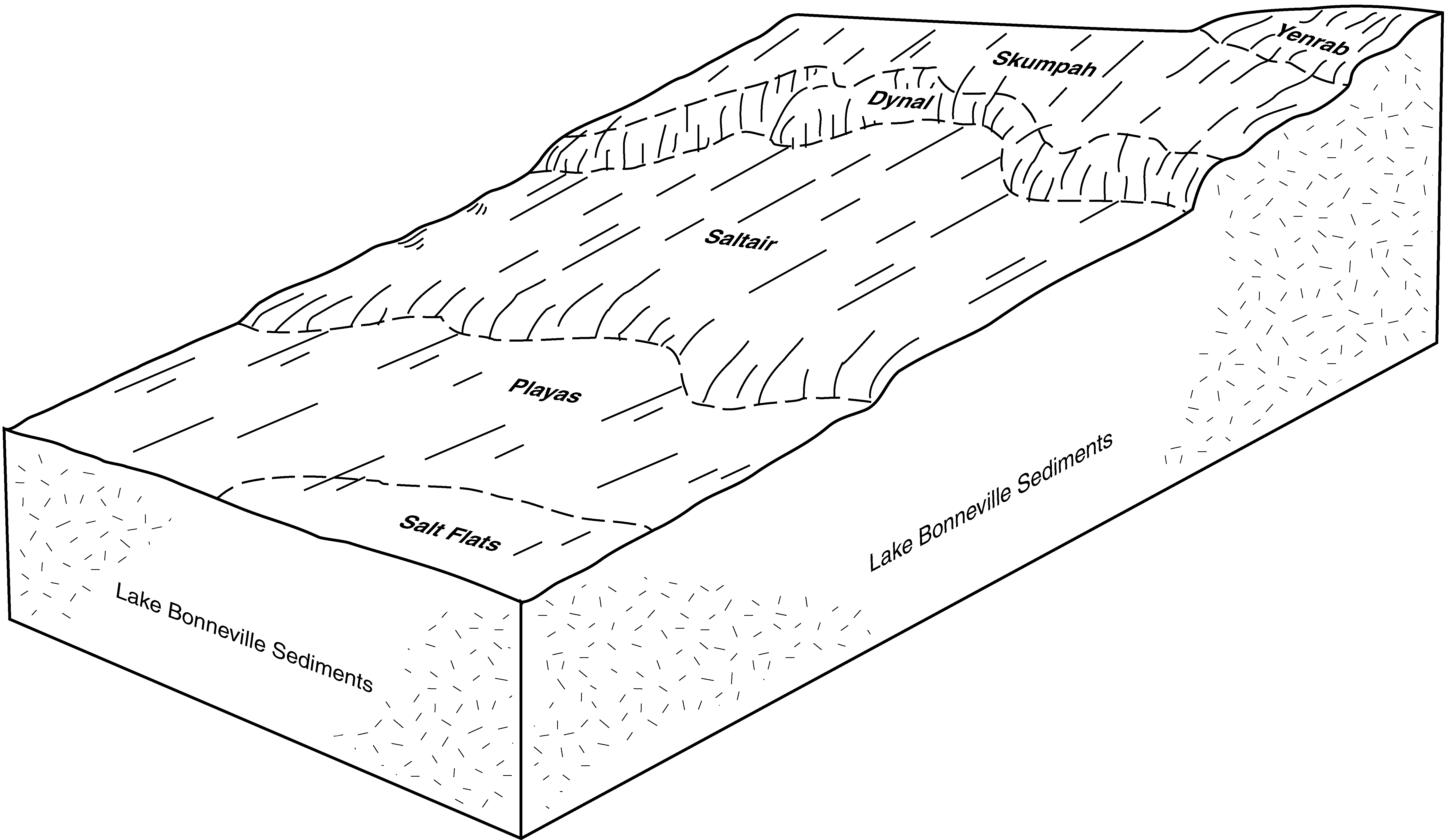
Skumpah-Playas complex, 1 to 3 percent slopes | 78 | 167102 | 481290 | j4th | ut601 | 1985 | 1:24000 |
Saltair-Playas association, 0 to 2 percent slopes | 74 | 87349 | 481286 | j4tc | ut601 | 1985 | 1:24000 |
Skumpah, sodic-Playas complex, 0 to 3 percent slopes | 79 | 83887 | 481291 | j4tj | ut601 | 1985 | 1:24000 |
Dynal-Playas association, 0 to 15 percent slopes | 30 | 10073 | 481238 | j4rt | ut601 | 1985 | 1:24000 |
Playas | PU | 80771 | 481438 | j4z8 | ut602 | 1969 | 1:20000 |
Pintailake-Eimarsh-Playas complex, 0 to 1 percent slopes | PEP | 30452 | 1545658 | 1nwcy | ut602 | 1969 | 1:20000 |
Eimarsh-Playas-Pintailake complex, 0 to 1 percent slopes | EP | 20231 | 1545659 | 1nwcz | ut602 | 1969 | 1:20000 |
Saltair-Playas-Lasil complex, 0 to 1 percent slopes | SPL | 19207 | 1545675 | 1nwdh | ut602 | 1969 | 1:20000 |
Playas, flooded | PF | 11873 | 1546460 | 1nx6t | ut602 | 1969 | 1:20000 |
Pintailake-Eimarsh-Playas complex, 0 to 1 percent slopes | PEP | 22140 | 1601210 | 1qr5y | ut607 | 1965 | 1:15840 |
Playas | PU | 14917 | 1601214 | 1qr62 | ut607 | 1965 | 1:15840 |
Saltair-Playas-Lasil complex, 0 to 1 percent slopes | SPL | 7159 | 1601211 | 1qr5z | ut607 | 1965 | 1:15840 |
Eimarsh-Playas-Pintailake complex, 0 to 1 percent slopes | EP | 4245 | 1601213 | 1qr61 | ut607 | 1965 | 1:15840 |
Playas | 45 | 1065384 | 482151 | j5q8 | ut611 | 1992 | 1:24000 |
Playas-Saltair complex, 0 to 1 percent slopes | 46 | 439896 | 482152 | j5q9 | ut611 | 1992 | 1:24000 |
Saltair-Playas complex, 0 to 1 percent slopes | 53 | 158918 | 482161 | j5ql | ut611 | 1992 | 1:24000 |
Saltair-Playas-Lasil complex, 0 to 1 percent slopes | SPL | 332 | 1673989 | 1t5xn | ut611 | 1992 | 1:24000 |
Pintailake-Eimarsh-Playas complex, 0 to 1 percent slopes | PEP | 14197 | 1601216 | 1qr64 | ut612 | 1967 | 1:20000 |
Saltair-Playas-Lasil complex, 0 to 1 percent slopes | SPL | 8665 | 1601217 | 1qr65 | ut612 | 1967 | 1:20000 |
Playas | PU | 6038 | 1601218 | 1qr66 | ut612 | 1967 | 1:20000 |
Eimarsh-Playas-Pintailake complex, 0 to 1 percent slopes | EP | 336 | 1697786 | 1tzp9 | ut612 | 1967 | 1:20000 |
Playas | 58 | 137578 | 3183884 | 2x4gf | ut617 | | 1:24000 |
Playas-Saltair-Yuba families complex, 0 to 8 percent slopes | 93 | 22002 | 3183923 | 2x4hp | ut617 | | 1:24000 |
Swingler family-Playas complex, 0 to 2 percent slopes | 80 | 11325 | 3183909 | 2x4h7 | ut617 | | 1:24000 |
Uvada-Playas complex, 0 to 2 percent slopes | 104 | 16089 | 2220427 | 2djjp | ut626 | | 1:24000 |
Thermosprings-Playas association | 171 | 4207 | 2220493 | 2djlt | ut626 | | 1:24000 |
Woodrow, moderately saline-Musinia, moderately saline-Playas association | 147 | 3953 | 2220469 | 2djl1 | ut626 | | 1:24000 |
Saltair-Playas association | 120 | 670 | 2220443 | 2djk6 | ut626 | | 1:24000 |
Pengpong-Playas association | 146 | 183 | 2220468 | 2djl0 | ut626 | | 1:24000 |
Playas | PM | 61615 | 482409 | j5zl | ut632 | 1970 | 1:20000 |
Playas-Abbott association | PN | 6558 | 482410 | j5zm | ut632 | 1970 | 1:20000 |
Playas | 449 | 6473 | 483987 | j7mh | ut634 | 1997 | 1:24000 |
Playas | 112 | 1134 | 3441782 | jxt1 | ut636 | 1984 | 1:24000 |
Playas | Py | 1050 | 55302 | 1vjy | ut643 | 1976 | 1:63000 |
Playas | PY | 471 | 3133236 | 2ynlv | wy629 | | 1:24000 |