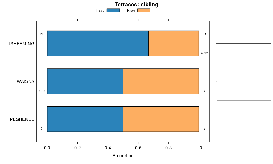
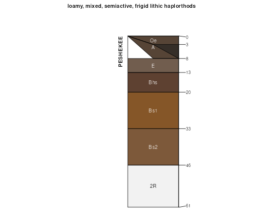
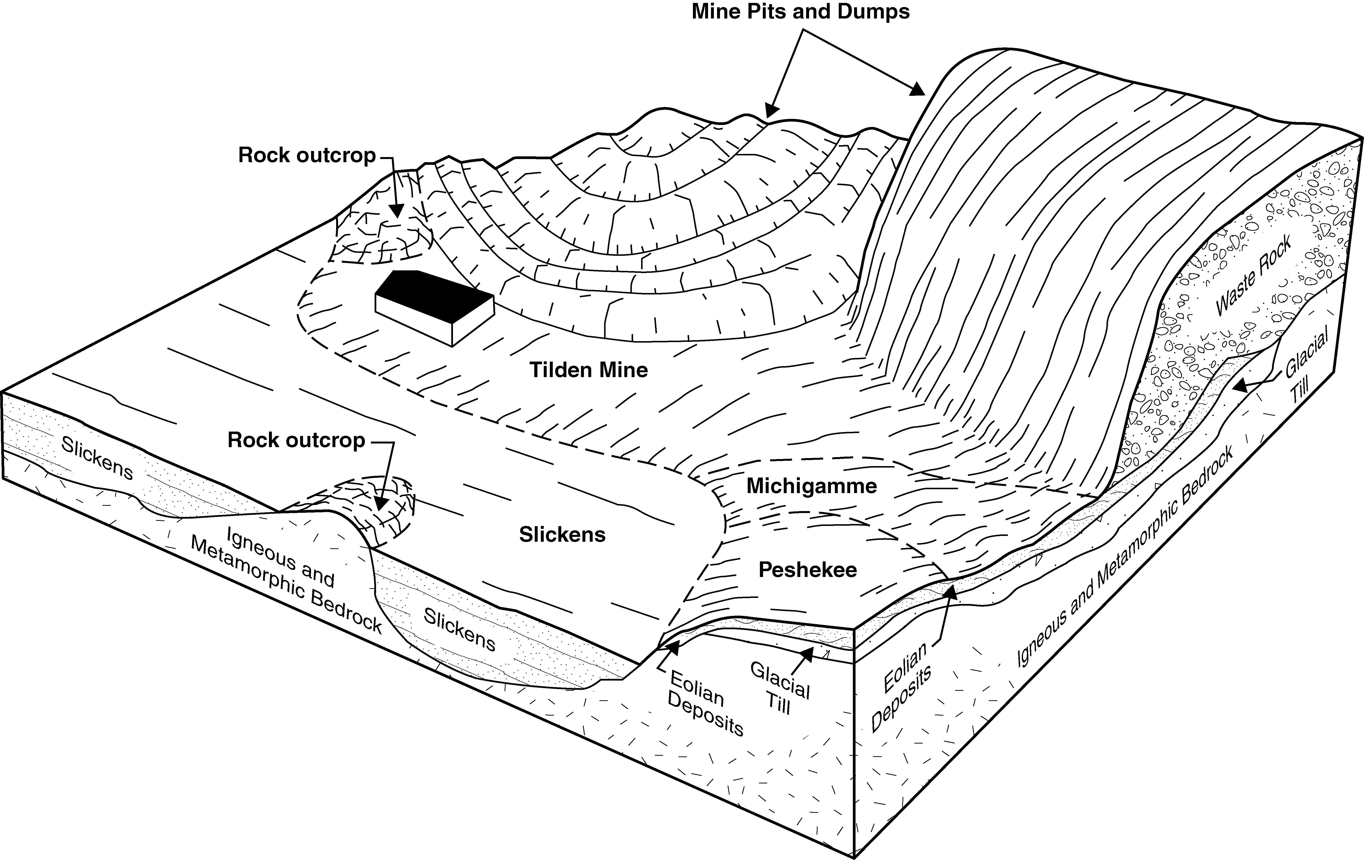
| Peshekee-Rock outcrop complex, 35 to 70 percent slopes | 101F | 1810 | 414922 | fxrl | mi013 | 1984 | 1:20000 |
Peshekee-Rock outcrop complex, 15 to 35 percent slopes | 101E | 1371 | 414921 | fxrk | mi013 | 1984 | 1:20000 |
Gogebic-Peshekee complex, 6 to 18 percent slopes, very rocky, very stony | 429C | 14956 | 1456130 | 1kw6y | mi053 | 2007 | 1:24000 |
Gogebic-Peshekee complex, 1 to 6 percent slopes, very rocky, very stony | 429B | 5605 | 1456129 | 1kw6x | mi053 | 2007 | 1:24000 |
Dishno-Gogebic-Peshekee-Rock outcrop complex, 18 to 35 percent slopes, very stony | 369D | 2961 | 1456000 | 1kw2r | mi053 | 2007 | 1:24000 |
Michigamme-Schweitzer-Peshekee-Rock outcrop complex, 35 to 55 percent slopes, very stony | 369E | 1328 | 1456001 | 1kw2s | mi053 | 2007 | 1:24000 |
Gogebic-Peshekee complex, 18 to 35 percent slopes, very rocky, very stony | 429D | 1145 | 1456131 | 1kw6z | mi053 | 2007 | 1:24000 |
Michigamme-Schweitzer-Peshekee-Rock outcrop complex, 55 to 75 percent slopes, very stony | 369F | 1029 | 1456002 | 1kw2t | mi053 | 2007 | 1:24000 |
Dishno-Gogebic-Peshekee-Rock outcrop complex, 6 to 18 percent slopes, very stony | 369C | 727 | 1455999 | 1kw2q | mi053 | 2007 | 1:24000 |
Schweitzer-Peshekee complex, 35 to 55 percent slopes, very rocky, very stony | 429E | 598 | 1456132 | 1kw70 | mi053 | 2007 | 1:24000 |
Peshekee-Rock outcrop complex, 35 to 55 percent slopes, very stony | 370E | 205 | 1456003 | 1kw2v | mi053 | 2007 | 1:24000 |
Peshekee-Rock outcrop complex, 55 to 75 percent slopes, very stony | 370F | 192 | 1456004 | 1kw2w | mi053 | 2007 | 1:24000 |
Michigamme-Schweitzer-Peshekee-Rock outcrop complex, 55 to 75 percent slopes, very stony | 8369F | 132 | 2485821 | 2pfps | mi061 | 1989 | 1:20000 |
Rock outcrop-Talus-Peshekee complex, 18 to 70 percent slopes, very bouldery | 8365F | 72 | 2485763 | 2pfmx | mi061 | 1989 | 1:20000 |
Dishno-Gogebic-Peshekee-Rock outcrop complex, 6 to 18 percent slopes, very stony | 8369C | 15 | 2485818 | 2pfpp | mi061 | 1989 | 1:20000 |
Dishno-Gogebic-Peshekee-Rock outcrop complex, 18 to 35 percent slopes, very stony | 8369D | 6 | 2485819 | 2pfpq | mi061 | 1989 | 1:20000 |
Michigamme-Schweitzer-Peshekee-Rock outcrop complex, 35 to 55 percent slopes, very stony | 8369E | 3 | 2497545 | 1t6xc | mi061 | 1989 | 1:20000 |
Peshekee-Rock outcrop complex, 35 to 70 percent slopes, very bouldery | 56F | 12248 | 395234 | f88h | mi103 | 1999 | 1:24000 |
Peshekee-Rock outcrop complex, 18 to 35 percent slopes, very bouldery | 56E | 3135 | 395233 | f88g | mi103 | 1999 | 1:24000 |
Peshekee-Rock outcrop complex, 6 to 18 percent slopes, very bouldery | 56D | 1432 | 395232 | f88f | mi103 | 1999 | 1:24000 |
Michigamme-Schweitzer-Peshekee-Rock outcrop complex, 35 to 55 percent slopes, very stony | 8369E | 1087 | 1674941 | 1t6xc | mi131 | 2007 | 1:24000 |
Dishno-Gogebic-Peshekee-Rock outcrop complex, 18 to 35 percent slopes, very stony | 8369D | 927 | 1674940 | 1t6xb | mi131 | 2007 | 1:24000 |
Michigamme-Schweitzer-Peshekee-Rock outcrop complex, 55 to 75 percent slopes, very stony | 8369F | 674 | 1674942 | 1t6xd | mi131 | 2007 | 1:24000 |
Rock outcrop-Talus-Peshekee complex, 18 to 70 percent slopes, very bouldery | 142F | 541 | 1456575 | 1kwp9 | mi131 | 2007 | 1:24000 |
Peshekee-Rock outcrop complex, 35 to 55 percent slopes, very stony | 8370E | 229 | 1674943 | 1t6xf | mi131 | 2007 | 1:24000 |
Peshekee-Rock outcrop complex, 55 to 75 percent slopes, very stony | 8370F | 181 | 1674944 | 1t6xg | mi131 | 2007 | 1:24000 |
Schweitzer-Peshekee complex, 35 to 55 percent slopes, very rocky, very stony | 8429E | 153 | 1674954 | 1t6xs | mi131 | 2007 | 1:24000 |
Dishno-Gogebic-Peshekee-Rock outcrop complex, 6 to 18 percent slopes, very stony | 8369C | 108 | 1674939 | 1t6x9 | mi131 | 2007 | 1:24000 |
Gogebic-Peshekee complex, 6 to 18 percent slopes, very rocky, very stony | 8429C | 70 | 1674953 | 1t6xr | mi131 | 2007 | 1:24000 |
Gogebic-Peshekee complex, 1 to 6 percent slopes, very rocky, very stony | 8429B | 16 | 1674952 | 1t6xq | mi131 | 2007 | 1:24000 |
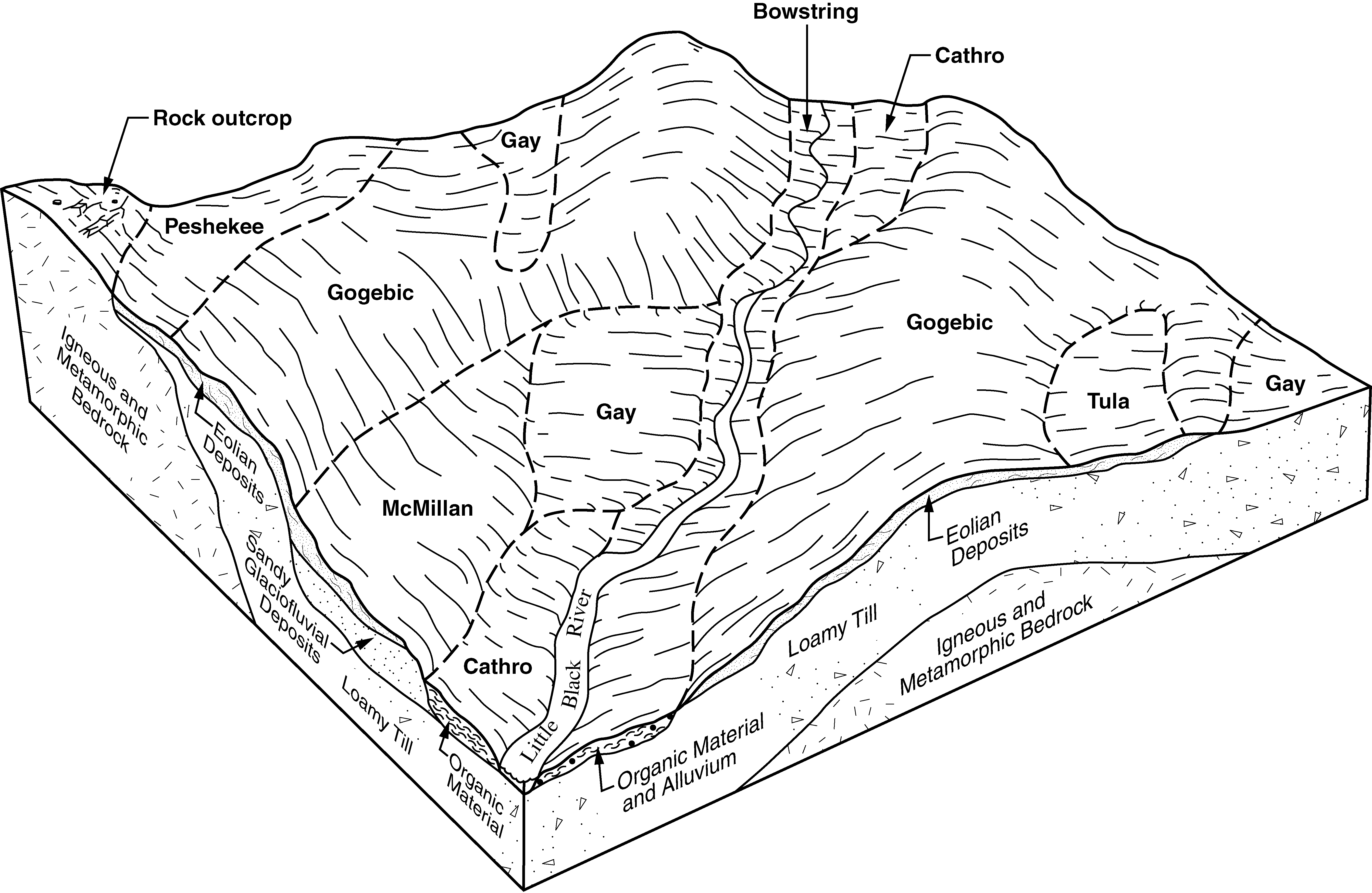
Michigamme-Peshekee-Rock outcrop complex, 4 to 26 percent slopes, very stony | 76E | 10526 | 2438014 | 2mtym | mi606 | | 1:12000 |
Michigamme-Peshekee complex, 5 to 21 percent slopes, very rocky, stony | 13D | 7807 | 1717908 | 1vnmd | mi606 | | 1:12000 |
Michigamme-Peshekee-Arcadian complex, 5 to 33 percent slopes, very rocky | 71E | 7593 | 2438006 | 2mtyc | mi606 | | 1:12000 |
Michigamme-Peshekee complex, 7 to 35 percent slopes, very rocky, stony | 13E | 4440 | 1717906 | 1vnmb | mi606 | | 1:12000 |
Quetico-Peshekee-Rock outcrop complex, 5 to 27 percent slopes, very stony | 11D | 3476 | 1717905 | 1vnm9 | mi606 | | 1:12000 |
Michigamme-Peshekee-Arcadian complex, 3 to 19 percent slopes, very rocky | 71D | 2131 | 2438005 | 2mtyb | mi606 | | 1:12000 |
Quetico-Peshekee-Rock outcrop complex, 6 to 34 percent slopes, very stony | 11E | 1946 | 1717886 | 1vnlp | mi606 | | 1:12000 |
Arcadian-Michigamme-Peshekee complex, 6 to 38 percent slopes, very rocky, very stony | 77E | 1482 | 2438015 | 2mtyn | mi606 | | 1:12000 |
Michigamme-Peshekee complex, 10 to 58 percent slopes, very rocky, stony | 13F | 1375 | 1717909 | 1vnmf | mi606 | | 1:12000 |
Michigamme-Peshekee complex, 3 to 13 percent slopes, very rocky, stony | 13C | 1353 | 2377684 | 2kt5h | mi606 | | 1:12000 |
Quetico-Peshekee-Rock outcrop complex, 6 to 56 percent slopes, very stony | 11F | 149 | 2485050 | 2pdwx | mi606 | | 1:12000 |
Michigamme-Schweitzer-Peshekee-Rock outcrop complex, 35 to 55 percent slopes, very stony | 5369F | 593 | 1702870 | 1v4z9 | wi003 | 2006 | 1:12000 |
Dishno-Gogebic-Peshekee-Rock outcrop complex, 18 to 35 percent slopes, very stony | 5869E | 423 | 1702869 | 1v4z8 | wi003 | 2006 | 1:12000 |
Michigamme-Schweitzer-Peshekee-Rock outcrop complex, 55 to 75 percent slopes, very stony | 5369G | 69 | 1702871 | 1v4zb | wi003 | 2006 | 1:12000 |
Gogebic-Peshekee complex, 6 to 18 percent slopes, very stony, very rocky | 5429D | 4611 | 1532168 | 1nfbs | wi051 | 2006 | 1:12000 |
Gogebic-Peshekee complex, 2 to 6 percent slopes, very stony, very rocky | 5429B | 3716 | 1532167 | 1nfbr | wi051 | 2006 | 1:12000 |
Michigamme-Schweitzer-Peshekee-Rock outcrop complex, 35 to 55 percent slopes, very stony | 5369F | 2240 | 1532161 | 1nfbk | wi051 | 2006 | 1:12000 |
Dishno-Gogebic-Peshekee-Rock outcrop complex, 18 to 35 percent slopes, very stony | 5869E | 2238 | 1700781 | 1v2sx | wi051 | 2006 | 1:12000 |
Michigamme-Schweitzer-Peshekee-Rock outcrop complex, 55 to 75 percent slopes, very stony | 5369G | 1378 | 1701226 | 1v388 | wi051 | 2006 | 1:12000 |
Gogebic-Peshekee complex, 18 to 35 percent slopes, very stony, very rocky | 5429E | 174 | 1532169 | 1nfbt | wi051 | 2006 | 1:12000 |
Peshekee-Rock outcrop complex, 4 to 30 percent slopes | 3531D | 2637 | 422506 | g5n7 | wi083 | 1985 | 1:15840 |


