| Vilas, very deep water table-Croswell-Pence, very deep water table, complex, 1 to 6 percent slopes | 8058B | 66 | 2475139 | 2p2l6 | mi013 | 1984 | 1:20000 |
Champion-Pence complex, 6 to 25 percent slopes, very rocky, extremely stony | 8090D | 59 | 2450789 | 2n87q | mi013 | 1984 | 1:20000 |
Karlin-Pence complex, 6 to 18 percent slopes | 8139C | 45 | 2450697 | 2n84r | mi013 | 1984 | 1:20000 |
Pence sandy loam, 0 to 6 percent slopes | 46B | 11445 | 415154 | 2tnyx | mi033 | 1989 | 1:15840 |
Pence sandy loam, 6 to 15 percent slopes | 46D | 1225 | 415155 | 2tnyy | mi033 | 1989 | 1:15840 |
Pence sandy loam, 15 to 35 percent slopes | 46E | 961 | 415156 | 2tnyz | mi033 | 1989 | 1:15840 |
Pence sandy loam, 0 to 6 percent slopes | 25B | 6444 | 415209 | 2tnyx | mi043 | 1985 | 1:20000 |
Pence sandy loam, 6 to 15 percent slopes | 25D | 1461 | 415210 | 2tnyy | mi043 | 1985 | 1:20000 |
Pence sandy loam, 15 to 35 percent slopes | 25F | 1268 | 415211 | 2tnyz | mi043 | 1985 | 1:20000 |
Pence-Vilas complex, 1 to 6 percent slopes | 52B | 6057 | 1456229 | 1kwb4 | mi053 | 2007 | 1:24000 |
Karlin-Pence complex, 6 to 18 percent slopes | 43C | 3321 | 1455946 | 1kw10 | mi053 | 2007 | 1:24000 |
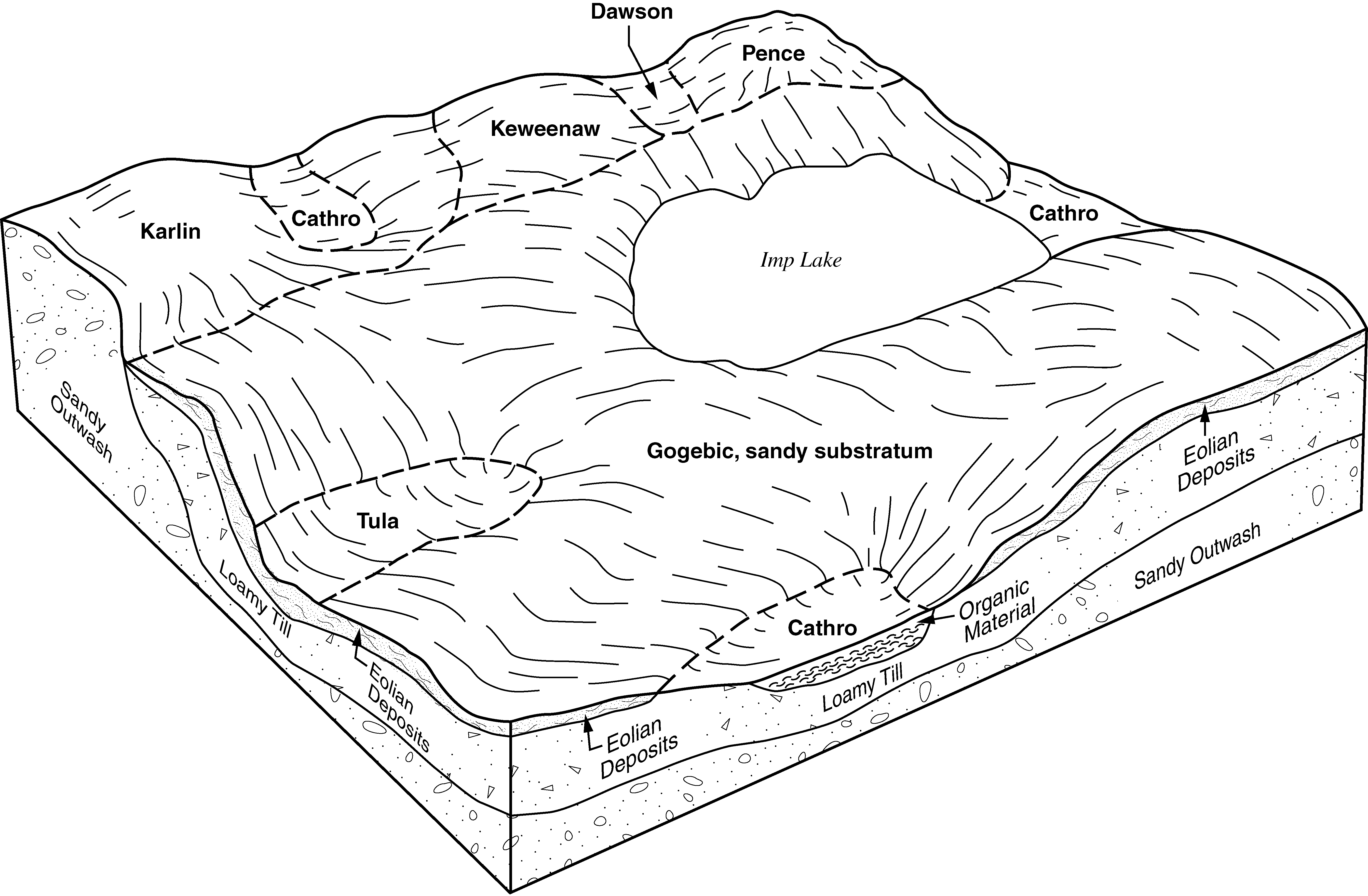
Gogebic, sandy substratum-Pence-Cathro complex, 0 to 18 percent slopes | 5172C | 3214 | 1455968 | 1kw1q | mi053 | 2007 | 1:24000 |
Karlin-Pence complex, 1 to 6 percent slopes | 43B | 2059 | 1455945 | 1kw0z | mi053 | 2007 | 1:24000 |
Pence-Lode complex, 1 to 6 percent slopes | 20B | 1415 | 1456361 | 1kwgd | mi053 | 2007 | 1:24000 |
Vilas, very deep water table-Croswell-Pence, very deep water table, complex, 1 to 6 percent slopes | 58B | 1376 | 1456239 | 1kwbg | mi053 | 2007 | 1:24000 |
Chabeneau-Karlin-Pence complex, 1 to 6 percent slopes | 23B | 1102 | 1456023 | 1kw3h | mi053 | 2007 | 1:24000 |
Pence-Vilas complex, 6 to 18 percent slopes | 52C | 901 | 1456230 | 1kwb5 | mi053 | 2007 | 1:24000 |
Gogebic, sandy substratum-Pence-Cathro complex, 0 to 6 percent slopes | 5172B | 706 | 1455967 | 1kw1p | mi053 | 2007 | 1:24000 |
Karlin-Pence complex, 18 to 35 percent slopes | 43D | 616 | 1455947 | 1kw11 | mi053 | 2007 | 1:24000 |
Pence sandy loam, 6 to 15 percent slopes | 20C | 184 | 1456362 | 2tnyy | mi053 | 2007 | 1:24000 |
Gogebic, sandy substratum-Pence complex, 18 to 35 percent slopes | 5173D | 180 | 1455970 | 1kw1s | mi053 | 2007 | 1:24000 |
Gogebic, sandy substratum-Pence-Cathro complex, 0 to 35 percent slopes | 5172D | 177 | 1455969 | 1kw1r | mi053 | 2007 | 1:24000 |
Pence sandy loam, 0 to 6 percent slopes | 29B | 156 | 1456368 | 2tnyx | mi053 | 2007 | 1:24000 |
Kalkaska-Pence-Stutts complex, 6 to 18 percent slopes | 8073C | 579 | 2486120 | 2pg0f | mi061 | 1989 | 1:20000 |
Kalkaska-Pence-Stutts complex, 18 to 35 percent slopes | 8073D | 542 | 2486121 | 2pg0g | mi061 | 1989 | 1:20000 |
Vilas, very deep water table-Croswell-Pence, very deep water table, complex, 1 to 6 percent slopes | 8058B | 315 | 2486060 | 2pfyh | mi061 | 1989 | 1:20000 |
Kalkaska-Pence-Stutts complex, 35 to 50 percent slopes | 8073E | 308 | 2486122 | 2pg0h | mi061 | 1989 | 1:20000 |
Kalkaska-Pence-Stutts complex, 0 to 6 percent slopes | 8073B | 180 | 2486119 | 2pg0d | mi061 | 1989 | 1:20000 |
Karlin-Pence complex, 6 to 18 percent slopes | 8043C | 176 | 2485908 | 2pfsl | mi061 | 1989 | 1:20000 |
Karlin-Pence complex, 1 to 6 percent slopes | 8043B | 98 | 2485910 | 2pfsn | mi061 | 1989 | 1:20000 |
Gogebic-Pence complex, 6 to 35 percent slopes, very rocky, stony | 8034D | 95 | 2485694 | 2pfkp | mi061 | 1989 | 1:20000 |
Karlin-Pence complex, 18 to 35 percent slopes | 8043D | 78 | 2485909 | 2pfsm | mi061 | 1989 | 1:20000 |
Pence-Lode complex, 1 to 6 percent slopes | 20B | 11466 | 2450886 | 2n8bv | mi071 | 1992 | 1:20000 |
Pence sandy loam, 0 to 6 percent slopes | 80B | 10016 | 416026 | 2tnyx | mi071 | 1992 | 1:20000 |
Pence sandy loam, 6 to 15 percent slopes | 80D | 7120 | 416027 | 2tnyy | mi071 | 1992 | 1:20000 |
Karlin-Pence complex, 6 to 18 percent slopes | 43C | 3507 | 2452536 | 2nb22 | mi071 | 1992 | 1:20000 |
Gogebic-Pence complex, 6 to 35 percent slopes, very rocky, stony | 8034D | 2108 | 2452518 | 2nb1h | mi071 | 1992 | 1:20000 |
Chabeneau-Karlin-Pence complex, 1 to 6 percent slopes | 23B | 1413 | 2452483 | 2nb0c | mi071 | 1992 | 1:20000 |
Vilas, very deep water table-Croswell-Pence, very deep water table, complex, 1 to 6 percent slopes | 8058B | 1295 | 2475138 | 2p2l5 | mi071 | 1992 | 1:20000 |
Karlin-Pence complex, 1 to 6 percent slopes | 43B | 1024 | 2452535 | 2nb21 | mi071 | 1992 | 1:20000 |
Pence-Vilas complex, 1 to 6 percent slopes | 8052B | 572 | 2474957 | 2p2db | mi071 | 1992 | 1:20000 |
Pence sandy loam, 15 to 35 percent slopes | 80F | 462 | 416028 | 2tnyz | mi071 | 1992 | 1:20000 |
Karlin-Pence complex, 18 to 35 percent slopes | 43D | 386 | 2452537 | 2nb23 | mi071 | 1992 | 1:20000 |
Kalkaska-Pence-Stutts complex, 6 to 18 percent slopes | 8073C | 101 | 2475368 | 2p2tl | mi071 | 1992 | 1:20000 |
Champion-Pence complex, 6 to 25 percent slopes, very rocky, extremely stony | 8090D | 78 | 2478609 | 2p664 | mi071 | 1992 | 1:20000 |
Kalkaska-Pence-Stutts complex, 18 to 35 percent slopes | 8073D | 57 | 2475369 | 2p2tm | mi071 | 1992 | 1:20000 |
Kalkaska-Pence-Stutts complex, 0 to 6 percent slopes | 8073B | 53 | 2475367 | 2p2tk | mi071 | 1992 | 1:20000 |
Pence-Vilas complex, 6 to 18 percent slopes | 8052C | 40 | 2474958 | 2p2dc | mi071 | 1992 | 1:20000 |
Pence very fine sandy loam, 0 to 6 percent slopes | 104B | 777 | 631302 | p5xl | mi095 | 2004 | 1:24000 |
Pence sandy loam, 0 to 6 percent slopes | 200B | 633 | 631371 | 2tnyx | mi095 | 2004 | 1:24000 |
Pence very fine sandy loam, 6 to 15 percent slopes | 104D | 466 | 631303 | p5xm | mi095 | 2004 | 1:24000 |
Pence sandy loam, 6 to 15 percent slopes | 200D | 410 | 631372 | 2tnyy | mi095 | 2004 | 1:24000 |
Pence sandy loam, 15 to 35 percent slopes | 200E | 114 | 631373 | 2tnyz | mi095 | 2004 | 1:24000 |
Pence very fine sandy loam, 15 to 35 percent slopes | 104E | 75 | 631304 | p5xn | mi095 | 2004 | 1:24000 |
Pence sandy loam, 0 to 6 percent slopes | 38B | 20973 | 395199 | 2tnyx | mi103 | 1999 | 1:24000 |
Pence sandy loam, 6 to 15 percent slopes | 38D | 3592 | 395200 | 2tnyy | mi103 | 1999 | 1:24000 |
Pence fine sandy loam, 1 to 6 percent slopes, rocky, bouldery | 173B | 2358 | 395123 | f84x | mi103 | 1999 | 1:24000 |
Pence fine sandy loam, 6 to 18 percent slopes, rocky, bouldery | 173D | 2229 | 395124 | f84y | mi103 | 1999 | 1:24000 |
Pence sandy loam, 15 to 35 percent slopes | 38E | 1494 | 395201 | 2tnyz | mi103 | 1999 | 1:24000 |
Kalkaska-Pence-Stutts complex, 6 to 18 percent slopes | 8073C | 3142 | 1674803 | 1t6rx | mi131 | 2007 | 1:24000 |
Karlin-Pence complex, 6 to 18 percent slopes | 8043C | 3001 | 1674505 | 1t6g9 | mi131 | 2007 | 1:24000 |
Kalkaska-Pence-Stutts complex, 18 to 35 percent slopes | 8073D | 2404 | 1674804 | 1t6ry | mi131 | 2007 | 1:24000 |
Pence-Vilas complex, 1 to 6 percent slopes | 8052B | 1705 | 1674791 | 1t6rj | mi131 | 2007 | 1:24000 |
Kalkaska-Pence-Stutts complex, 35 to 50 percent slopes | 8073E | 1662 | 1674805 | 1t6rz | mi131 | 2007 | 1:24000 |
Karlin-Pence complex, 18 to 35 percent slopes | 8043D | 1301 | 1674506 | 1t6gb | mi131 | 2007 | 1:24000 |
Karlin-Pence complex, 1 to 6 percent slopes | 8043B | 1233 | 1674504 | 1t6g8 | mi131 | 2007 | 1:24000 |
Vilas, very deep water table-Croswell-Pence, very deep water table, complex, 1 to 6 percent slopes | 8058B | 753 | 1674795 | 1t6rn | mi131 | 2007 | 1:24000 |
Kalkaska-Pence-Stutts complex, 0 to 6 percent slopes | 8073B | 743 | 1674802 | 1t6rw | mi131 | 2007 | 1:24000 |
Pence-Vilas complex, 6 to 18 percent slopes | 8052C | 346 | 1674792 | 1t6rk | mi131 | 2007 | 1:24000 |
Gogebic-Pence complex, 6 to 35 percent slopes, very rocky, stony | 8034D | 59 | 1674492 | 1t6fw | mi131 | 2007 | 1:24000 |
Gogebic, very stony-Pence, very stony-Cathro complex, 0 to 18 percent slopes | 5172C | 37139 | 1702853 | 1v4yr | wi003 | 2006 | 1:12000 |
Keweenaw-Pence complex, 6 to 15 percent slopes, stony | 3670C | 11884 | 1444468 | 1kh2r | wi003 | 2006 | 1:12000 |
Gogebic, very stony-Pence, very stony-Cathro complex, 0 to 6 percent slopes | 5172B | 7478 | 1702852 | 1v4yq | wi003 | 2006 | 1:12000 |
Gogebic-Pence complex, 18 to 35 percent slopes, very stony | 5173E | 5469 | 1702855 | 1v4yt | wi003 | 2006 | 1:12000 |
Sayner-Pence-Vilas complex, 6 to 15 percent slopes | 3974C | 2855 | 1444518 | 1kh4c | wi003 | 2006 | 1:12000 |
Gogebic, very stony-Pence, very stony-Cathro complex, 0 to 35 percent slopes | 5172D | 1793 | 1702854 | 1v4ys | wi003 | 2006 | 1:12000 |
Pence sandy loam, 0 to 6 percent slopes | 3215B | 1710 | 1444383 | 2tnyx | wi003 | 2006 | 1:12000 |
Pence sandy loam, 6 to 15 percent slopes | 3215C | 1522 | 1444384 | 2tnyy | wi003 | 2006 | 1:12000 |
Shanagolden-Pence complex, 6 to 15 percent slopes, stony | 3770C | 1447 | 1611075 | 1r2g5 | wi003 | 2006 | 1:12000 |
Keweenaw-Pence complex, 15 to 45 percent slopes, stony | 3670F | 1054 | 1444469 | 1kh2s | wi003 | 2006 | 1:12000 |
Pence-Gogebic complex, 2 to 6 percent slopes, stony | 5519B | 1036 | 1702874 | 1v4zf | wi003 | 2006 | 1:12000 |
Shanagolden-Pence complex, 2 to 6 percent slopes, stony | 3770B | 732 | 1611074 | 1r2g4 | wi003 | 2006 | 1:12000 |
Pence sandy loam, 15 to 35 percent slopes | 3215E | 704 | 1444385 | 2tnyz | wi003 | 2006 | 1:12000 |
Pence-Gogebic complex, 6 to 18 percent slopes, stony | 5519D | 382 | 1702876 | 1v4zh | wi003 | 2006 | 1:12000 |
Keweenaw-Pence complex, 0 to 6 percent slopes, stony | 3670B | 273 | 1444467 | 1kh2q | wi003 | 2006 | 1:12000 |
Sayner-Pence-Vilas complex, 15 to 30 percent slopes | 3974E | 240 | 1444519 | 1kh4d | wi003 | 2006 | 1:12000 |
Shanagolden-Pence complex, 15 to 30 percent slopes, stony | 3770E | 211 | 1611076 | 1r2g6 | wi003 | 2006 | 1:12000 |
Sayner-Pence-Vilas complex, 0 to 6 percent slopes | 3974B | 192 | 1444517 | 1kh4b | wi003 | 2006 | 1:12000 |
Padus-Pence sandy loams, 6 to 15 percent slopes | 3852C | 80 | 1601899 | 2tnz1 | wi003 | 2006 | 1:12000 |
Padus-Pence-Keweenaw complex, 15 to 30 percent slopes, stony | 3582E | 65 | 1703709 | 1v5vc | wi003 | 2006 | 1:12000 |
Pence-Gogebic complex, 18 to 35 percent slopes, stony | 5519E | 30 | 1702878 | 1v4zk | wi003 | 2006 | 1:12000 |
Padus-Pence sandy loams, 15 to 35 percent slopes | 3852E | 18 | 1601898 | 2tnz2 | wi003 | 2006 | 1:12000 |
Gogebic, very stony-Pence, very stony-Cathro complex, 0 to 18 percent slopes | 5172C | 31671 | 1147454 | 17j0n | wi007 | 2005 | 1:12000 |
Padus-Pence-Keweenaw complex, 15 to 30 percent slopes, stony | 3582E | 14801 | 782484 | v87f | wi007 | 2005 | 1:12000 |
Keweenaw-Pence complex, 6 to 15 percent slopes, stony | 3670C | 12339 | 782489 | v87l | wi007 | 2005 | 1:12000 |
Gogebic, very stony-Pence, very stony-Cathro complex, 0 to 6 percent slopes | 5172B | 12194 | 1380245 | 1hb81 | wi007 | 2005 | 1:12000 |
Padus-Pence-Keweenaw complex, 6 to 15 percent slopes, stony | 3582C | 10101 | 782483 | v87d | wi007 | 2005 | 1:12000 |
Keweenaw-Pence complex, 15 to 45 percent slopes, stony | 3670F | 8128 | 782490 | v87m | wi007 | 2005 | 1:12000 |
Sayner-Pence-Vilas complex, 6 to 15 percent slopes | 3974C | 5659 | 782505 | v883 | wi007 | 2005 | 1:12000 |
Pence sandy loam, 0 to 6 percent slopes | 3215B | 4881 | 433367 | 2tnyx | wi007 | 2005 | 1:12000 |
Gogebic-Pence complex, 18 to 35 percent slopes, very stony | 5173E | 4576 | 1146422 | 17gyc | wi007 | 2005 | 1:12000 |
Stanberry-Pence complex, 2 to 6 percent slopes, stony | 3680B | 3228 | 1383663 | 1hft9 | wi007 | 2005 | 1:12000 |
Sayner-Pence-Vilas complex, 15 to 30 percent slopes | 3974E | 1713 | 782506 | v884 | wi007 | 2005 | 1:12000 |
Gogebic, very stony-Pence, very stony-Cathro complex, 0 to 35 percent slopes | 5172D | 1478 | 1147455 | 17j0p | wi007 | 2005 | 1:12000 |
Sayner-Pence-Vilas complex, 0 to 6 percent slopes | 3974B | 1438 | 1380109 | 1hb3n | wi007 | 2005 | 1:12000 |
Padus-Pence-Keweenaw complex, 0 to 6 percent slopes, stony | 3582B | 1386 | 1383654 | 1hft0 | wi007 | 2005 | 1:12000 |
Keweenaw, stony-Pence, stony-Cathro complex, 0 to 15 percent slopes | 3760C | 1297 | 1147446 | 17j0d | wi007 | 2005 | 1:12000 |
Pence sandy loam, 15 to 35 percent slopes | 3215E | 763 | 433371 | 2tnyz | wi007 | 2005 | 1:12000 |
Pence sandy loam, 6 to 15 percent slopes | 3215C | 612 | 433369 | 2tnyy | wi007 | 2005 | 1:12000 |
Pence and Padus soils, 30 to 45 percent slopes | 3633F | 567 | 782488 | v87k | wi007 | 2005 | 1:12000 |
Keweenaw-Pence complex, 0 to 6 percent slopes, stony | 3670B | 486 | 1383993 | 1hg4y | wi007 | 2005 | 1:12000 |
Keweenaw, stony-Pence, stony-Cathro complex, 0 to 45 percent slopes | 3760E | 137 | 1383879 | 1hg18 | wi007 | 2005 | 1:12000 |
Keweenaw-Pence complex, 6 to 15 percent slopes, stony | 3670C | 8288 | 781423 | v746 | wi031 | 2005 | 1:12000 |
Newood-Pence complex, 1 to 6 percent slopes, very stony | 3547B | 4552 | 1380051 | 1hb1s | wi031 | 2005 | 1:12000 |
Keweenaw-Pence complex, 15 to 45 percent slopes, stony | 3670F | 2061 | 781424 | v747 | wi031 | 2005 | 1:12000 |
Pence sandy loam, 0 to 6 percent slopes | 3215B | 720 | 781147 | 2tnyx | wi031 | 2005 | 1:12000 |
Pence sandy loam, 6 to 15 percent slopes | 3215C | 419 | 781148 | 2tnyy | wi031 | 2005 | 1:12000 |
Pence sandy loam, 15 to 35 percent slopes | 3215E | 67 | 781149 | 2tnyz | wi031 | 2005 | 1:12000 |
Padus-Pence sandy loams, 15 to 35 percent slopes | 3852E | 18717 | 430023 | 2tnz2 | wi037 | 1995 | 1:12000 |
Padus-Pence sandy loams, 6 to 15 percent slopes | 3852C | 12878 | 430022 | 2tnz1 | wi037 | 1995 | 1:12000 |
Padus-Pence sandy loams, 0 to 6 percent slopes | 3852B | 7422 | 430021 | 2tnz0 | wi037 | 1995 | 1:12000 |
Pence sandy loam, 0 to 6 percent slopes | 3215B | 7025 | 430025 | 2tnyx | wi037 | 1995 | 1:12000 |
Pence sandy loam, 6 to 15 percent slopes | 3215C | 6183 | 430026 | 2tnyy | wi037 | 1995 | 1:12000 |
Pence-Vilas complex, 6 to 15 percent slopes | 3219C | 4628 | 430029 | gfgx | wi037 | 1995 | 1:12000 |
Pence sandy loam, 15 to 35 percent slopes | 3215E | 4151 | 430027 | 2tnyz | wi037 | 1995 | 1:12000 |
Pence-Vilas complex, 0 to 6 percent slopes | 3219B | 3642 | 430028 | gfgw | wi037 | 1995 | 1:12000 |
Pence-Vilas complex, 15 to 35 percent slopes | 3219E | 3438 | 430030 | gfgy | wi037 | 1995 | 1:12000 |
Padus-Pence sandy loams, 6 to 15 percent slopes | 3852C | 39081 | 429853 | 2tnz1 | wi041 | 1995 | 1:12000 |
Padus-Pence sandy loams, 15 to 35 percent slopes | 3852E | 32013 | 429854 | 2tnz2 | wi041 | 1995 | 1:12000 |
Padus-Pence sandy loams, 0 to 6 percent slopes | 3852B | 10722 | 429852 | 2tnz0 | wi041 | 1995 | 1:12000 |
Pence-Vilas complex, 6 to 15 percent slopes | 3219C | 9721 | 429864 | gf9l | wi041 | 1995 | 1:12000 |
Pence-Vilas complex, 0 to 6 percent slopes | 3219B | 4611 | 429863 | gf9k | wi041 | 1995 | 1:12000 |
Pence-Vilas complex, 15 to 35 percent slopes | 3219E | 4495 | 429865 | gf9m | wi041 | 1995 | 1:12000 |
Pence sandy loam, 15 to 35 percent slopes | 3215E | 2903 | 429862 | 2tnyz | wi041 | 1995 | 1:12000 |
Pence sandy loam, 6 to 15 percent slopes | 3215C | 2539 | 429861 | 2tnyy | wi041 | 1995 | 1:12000 |
Pence sandy loam, 0 to 6 percent slopes | 3215B | 2027 | 429860 | 2tnyx | wi041 | 1995 | 1:12000 |
Gogebic, very stony-Pence, very stony-Cathro complex, 0 to 18 percent slopes | 5172C | 61535 | 1532144 | 1nfb0 | wi051 | 2006 | 1:12000 |
Gogebic, very stony-Pence, very stony-Cathro complex, 0 to 6 percent slopes | 5172B | 22727 | 1532143 | 1nf9z | wi051 | 2006 | 1:12000 |
Pence sandy loam, 0 to 6 percent slopes | 3215B | 5169 | 782015 | 2tnyx | wi051 | 2006 | 1:12000 |
Keweenaw-Pence complex, 6 to 15 percent slopes, stony | 3670C | 4620 | 1701121 | 1v34w | wi051 | 2006 | 1:12000 |
Pence-Gogebic complex, 2 to 6 percent slopes, stony | 5519B | 3690 | 1532175 | 1nfc0 | wi051 | 2006 | 1:12000 |
Gogebic, very stony-Pence, very stony-Cathro complex, 0 to 35 percent slopes | 5172D | 3464 | 1532145 | 1nfb1 | wi051 | 2006 | 1:12000 |
Pence-Gogebic complex, 6 to 18 percent slopes, stony | 5519D | 3281 | 1532176 | 1nfc1 | wi051 | 2006 | 1:12000 |
Pence sandy loam, 6 to 15 percent slopes | 3215C | 2876 | 782016 | 2tnyy | wi051 | 2006 | 1:12000 |
Padus-Pence sandy loams, 6 to 15 percent slopes | 3852C | 2769 | 782367 | 2tnz1 | wi051 | 2006 | 1:12000 |
Gogebic-Pence complex, 18 to 35 percent slopes, very stony | 5173E | 2629 | 782135 | v7w5 | wi051 | 2006 | 1:12000 |
Sayner-Pence-Vilas complex, 6 to 15 percent slopes | 3974C | 2197 | 782412 | v853 | wi051 | 2006 | 1:12000 |
Keweenaw-Pence complex, 15 to 45 percent slopes, stony | 3670F | 1503 | 782292 | v817 | wi051 | 2006 | 1:12000 |
Gogebic, very stony-Pence, very stony-Cathro complex, 0 to 18 percent slopes, rocky | 5175C | 1409 | 1702443 | 1v4jj | wi051 | 2006 | 1:12000 |
Shanagolden-Pence complex, 2 to 6 percent slopes, stony | 3770B | 1270 | 1697696 | 1tzld | wi051 | 2006 | 1:12000 |
Shanagolden-Pence complex, 6 to 15 percent slopes, stony | 3770C | 1255 | 1697697 | 1tzlf | wi051 | 2006 | 1:12000 |
Pence sandy loam, 15 to 35 percent slopes | 3215E | 1053 | 782017 | 2tnyz | wi051 | 2006 | 1:12000 |
Padus-Pence sandy loams, 15 to 35 percent slopes | 3852E | 1003 | 782368 | 2tnz2 | wi051 | 2006 | 1:12000 |
Sayner-Pence-Vilas complex, 0 to 6 percent slopes | 3974B | 830 | 1697699 | 1tzlh | wi051 | 2006 | 1:12000 |
Keweenaw-Pence complex, 0 to 6 percent slopes, stony | 3670B | 587 | 1701119 | 1v34t | wi051 | 2006 | 1:12000 |
Sayner-Pence-Vilas complex, 15 to 30 percent slopes | 3974E | 540 | 782413 | v854 | wi051 | 2006 | 1:12000 |
Pence-Gogebic complex, 18 to 35 percent slopes, stony | 5519E | 487 | 1532177 | 1nfc2 | wi051 | 2006 | 1:12000 |
Gogebic, very stony-Pence, very stony-Cathro complex, 0 to 35 percent slopes, rocky | 5175D | 213 | 1702444 | 1v4jk | wi051 | 2006 | 1:12000 |
Padus-Pence-Keweenaw complex, 6 to 15 percent slopes, stony | 3582C | 73 | 1701267 | 1v39l | wi051 | 2006 | 1:12000 |
Shanagolden-Pence complex, 15 to 30 percent slopes, stony | 3770E | 28 | 1697698 | 1tzlg | wi051 | 2006 | 1:12000 |
Padus-Pence-Keweenaw complex, 15 to 30 percent slopes, stony | 3582E | 26 | 1701269 | 1v39n | wi051 | 2006 | 1:12000 |
Pence sandy loam, 15 to 35 percent slopes | 3215E | 42582 | 421069 | 2tnyz | wi067 | 1983 | 1:20000 |
Pence sandy loam, 6 to 15 percent slopes | 3215C | 10753 | 421068 | 2tnyy | wi067 | 1983 | 1:20000 |
Pence sandy loam, 0 to 6 percent slopes | 3215B | 5409 | 421067 | 2tnyx | wi067 | 1983 | 1:20000 |
Sarona-Pence sandy loams, 6 to 15 percent slopes | 3662C | 18478 | 431648 | gh54 | wi069 | 1993 | 1:20000 |
Padus-Pence sandy loams, 6 to 15 percent slopes | 3852C | 13021 | 431644 | 2tnz1 | wi069 | 1993 | 1:20000 |
Padus-Pence sandy loams, 0 to 6 percent slopes | 3852B | 12899 | 431643 | 2tnz0 | wi069 | 1993 | 1:20000 |
Sarona-Pence sandy loams, 15 to 35 percent slopes | 3662E | 11608 | 431649 | gh55 | wi069 | 1993 | 1:20000 |
Padus-Pence sandy loams, 15 to 35 percent slopes | 3852E | 8852 | 431645 | 2tnz2 | wi069 | 1993 | 1:20000 |
Newood-Pence complex, 6 to 15 percent slopes, very stony | 3546C | 4829 | 431636 | 2zcw4 | wi069 | 1993 | 1:20000 |
Pence-Antigo complex, 6 to 15 percent slopes | 3215C | 2000 | 431642 | gh4y | wi069 | 1993 | 1:20000 |
Pence sandy loam, 0 to 6 percent slopes | 3215B | 14690 | 422432 | 2tnyx | wi075 | 1987 | 1:20000 |
Emmert-Pence-Sarona complex, 15 to 35 percent slopes | 3852E | 10935 | 422387 | g5jd | wi075 | 1987 | 1:20000 |
Emmert-Pence-Sarona complex, 6 to 15 percent slopes | 3852C | 9327 | 422386 | g5jc | wi075 | 1987 | 1:20000 |
Pence sandy loam, 6 to 15 percent slopes | 3215C | 4482 | 422433 | 2tnyy | wi075 | 1987 | 1:20000 |
Pence sandy loam, 15 to 35 percent slopes | 3215E | 2751 | 395845 | 2tnyz | wi078 | 1998 | 1:12000 |
Pence sandy loam, 6 to 15 percent slopes | 3215C | 313 | 395846 | 2tnyy | wi078 | 1998 | 1:12000 |
Pence sandy loam, 0 to 6 percent slopes | 3215B | 124 | 395844 | 2tnyx | wi078 | 1998 | 1:12000 |
Pence sandy loam, 15 to 35 percent slopes | 3215E | 14053 | 422505 | 2tnyz | wi083 | 1985 | 1:15840 |
Pence sandy loam, 6 to 15 percent slopes | 3215C | 13764 | 422504 | 2tnyy | wi083 | 1985 | 1:15840 |
Pence sandy loam, 0 to 6 percent slopes | 3215B | 11082 | 422503 | 2tnyx | wi083 | 1985 | 1:15840 |
Padus-Pence sandy loams, 6 to 15 percent slopes | 3852C | 38312 | 421108 | 2tnz1 | wi085 | 1988 | 1:20000 |
Padus-Pence sandy loams, 0 to 6 percent slopes | 3852B | 34374 | 421107 | 2tnz0 | wi085 | 1988 | 1:20000 |
Padus-Pence sandy loams, 15 to 35 percent slopes | 3852E | 33251 | 421109 | 2tnz2 | wi085 | 1988 | 1:20000 |
Shanagolden-Pence complex, 6 to 15 percent slopes, stony | 3770C | 11446 | 1379837 | 1h9tw | wi099 | 2006 | 1:12000 |
Shanagolden-Pence complex, 2 to 6 percent slopes, stony | 3770B | 8040 | 1379838 | 1h9tx | wi099 | 2006 | 1:12000 |
Pence sandy loam, 6 to 15 percent slopes | 3215C | 6819 | 627349 | 2tnyy | wi099 | 2006 | 1:12000 |
Newood-Pence complex, 6 to 15 percent slopes, very stony | 3546C | 6689 | 1482739 | 2zcw4 | wi099 | 2006 | 1:12000 |
Newot-Pence complex, 15 to 45 percent slopes, very stony | 3346F | 6194 | 627367 | p1tn | wi099 | 2006 | 1:12000 |
Sayner-Pence-Vilas complex, 6 to 15 percent slopes | 3974C | 6018 | 1395729 | 1hvcj | wi099 | 2006 | 1:12000 |
Pence sandy loam, 0 to 6 percent slopes | 3215B | 5387 | 627348 | 2tnyx | wi099 | 2006 | 1:12000 |
Pence sandy loam, 15 to 35 percent slopes | 3215E | 5311 | 627350 | 2tnyz | wi099 | 2006 | 1:12000 |
Keweenaw-Pence complex, 6 to 15 percent slopes, stony | 3670C | 5163 | 1395721 | 1hvc8 | wi099 | 2006 | 1:12000 |
Shanagolden-Pence complex, 15 to 30 percent slopes, stony | 3770E | 4393 | 1379836 | 1h9tv | wi099 | 2006 | 1:12000 |
Sayner-Pence-Vilas complex, 15 to 30 percent slopes | 3974E | 2973 | 1395728 | 1hvch | wi099 | 2006 | 1:12000 |
Newood-Pence complex, 2 to 6 percent slopes, very stony | 3546B | 2913 | 1482738 | 1lrx8 | wi099 | 2006 | 1:12000 |
Crystal Lake-Newot, very stony-Pence complex, 15 to 35 percent slopes | 3864E | 2384 | 1482758 | 1lrxx | wi099 | 2006 | 1:12000 |
Padus-Pence sandy loams, 6 to 15 percent slopes | 3852C | 1639 | 627644 | 2tnz1 | wi099 | 2006 | 1:12000 |
Keweenaw-Pence complex, 0 to 6 percent slopes, stony | 3670B | 1039 | 1395720 | 1hvc7 | wi099 | 2006 | 1:12000 |
Newood-Pence complex, 15 to 30 percent slopes, very stony | 3546E | 730 | 1482740 | 1lrxb | wi099 | 2006 | 1:12000 |
Padus-Pence sandy loams, 15 to 35 percent slopes | 3852E | 311 | 627645 | 2tnz2 | wi099 | 2006 | 1:12000 |
Keweenaw-Pence complex, 15 to 45 percent slopes, stony | 3670F | 179 | 1395722 | 1hvc9 | wi099 | 2006 | 1:12000 |
Sayner-Pence-Vilas complex, 0 to 6 percent slopes | 3974B | 143 | 1395730 | 1hvck | wi099 | 2006 | 1:12000 |
Newot-Pence complex, 15 to 45 percent slopes, very stony | 3346F | 4125 | 625163 | nzjk | wi107 | 2006 | 1:12000 |
Pence sandy loam, 0 to 6 percent slopes | 3215B | 3657 | 625061 | 2tnyx | wi107 | 2006 | 1:12000 |
Newood-Pence complex, 6 to 15 percent slopes, very stony | 3546C | 2882 | 1481496 | 2zcw4 | wi107 | 2006 | 1:12000 |
Pence sandy loam, 6 to 15 percent slopes | 3215C | 2653 | 625062 | 2tnyy | wi107 | 2006 | 1:12000 |
Pence sandy loam, 15 to 35 percent slopes | 3215E | 2004 | 625063 | 2tnyz | wi107 | 2006 | 1:12000 |
Pence-Sconsin-Tawas complex, 0 to 25 percent slopes | 3746D | 138 | 757625 | tfcj | wi107 | 2006 | 1:12000 |
Keweenaw-Pence complex, 6 to 15 percent slopes, stony | 3670C | 17004 | 625876 | p08k | wi113 | 2006 | 1:12000 |
Pence sandy loam, 6 to 15 percent slopes | 3215C | 14226 | 625380 | 2tnyy | wi113 | 2006 | 1:12000 |
Padus-Pence-Keweenaw complex, 6 to 15 percent slopes, stony | 3582C | 12868 | 625862 | p083 | wi113 | 2006 | 1:12000 |
Padus-Pence-Keweenaw complex, 15 to 30 percent slopes, stony | 3582E | 11943 | 625863 | p084 | wi113 | 2006 | 1:12000 |
Pence sandy loam, 0 to 6 percent slopes | 3215B | 11304 | 625379 | 2tnyx | wi113 | 2006 | 1:12000 |
Pence sandy loam, 15 to 35 percent slopes | 3215E | 10680 | 625381 | 2tnyz | wi113 | 2006 | 1:12000 |
Keweenaw-Pence complex, 15 to 45 percent slopes, stony | 3670F | 7962 | 625877 | p08l | wi113 | 2006 | 1:12000 |
Keweenaw, stony-Pence, stony-Greenwood complex, 0 to 45 percent slopes | 3970E | 4372 | 656078 | q0pt | wi113 | 2006 | 1:12000 |
Newood-Pence complex, 6 to 15 percent slopes, very stony | 3546C | 3886 | 1669947 | 2zcw4 | wi113 | 2006 | 1:12000 |
Stanberry-Pence complex, 2 to 6 percent slopes, stony | 3680B | 3047 | 811365 | w792 | wi113 | 2006 | 1:12000 |
Newot-Pence complex, 15 to 45 percent slopes, very stony | 3346F | 2586 | 625845 | p07k | wi113 | 2006 | 1:12000 |
Keweenaw, stony-Pence, stony-Greenwood complex, 0 to 15 percent slopes | 3970C | 1906 | 656085 | q0q1 | wi113 | 2006 | 1:12000 |
Keweenaw-Pence complex, 0 to 6 percent slopes, stony | 3670B | 1516 | 1386090 | 1hjbl | wi113 | 2006 | 1:12000 |
Sayner-Pence-Vilas complex, 6 to 15 percent slopes | 3974C | 1436 | 1386101 | 1hjby | wi113 | 2006 | 1:12000 |
Shanagolden-Pence complex, 6 to 15 percent slopes, stony | 3770C | 1033 | 1674485 | 1t6fn | wi113 | 2006 | 1:12000 |
Newood-Pence complex, 2 to 6 percent slopes, very stony | 3546B | 928 | 1672265 | 1t441 | wi113 | 2006 | 1:12000 |
Pence and Padus soils, 30 to 45 percent slopes | 3633F | 801 | 625875 | p08j | wi113 | 2006 | 1:12000 |
Padus-Pence-Keweenaw complex, 0 to 6 percent slopes, stony | 3582B | 484 | 1703428 | 1v5k9 | wi113 | 2006 | 1:12000 |
Sayner-Pence-Vilas complex, 15 to 30 percent slopes | 3974E | 386 | 1386100 | 1hjbx | wi113 | 2006 | 1:12000 |
Shanagolden-Pence complex, 15 to 30 percent slopes, stony | 3770E | 94 | 1674484 | 1t6fm | wi113 | 2006 | 1:12000 |
Shanagolden-Pence complex, 2 to 6 percent slopes, stony | 3770B | 91 | 1674486 | 1t6fp | wi113 | 2006 | 1:12000 |
Newot-Pence complex, 15 to 45 percent slopes, very stony | 3346F | 3939 | 420972 | g41r | wi119 | 2002 | 1:12000 |
Newood-Pence complex, 6 to 15 percent slopes, very stony | 3546C | 2808 | 435169 | 2zcw4 | wi119 | 2002 | 1:12000 |
Padus-Pence sandy loams, 15 to 35 percent slopes | 3852E | 1236 | 435191 | 2tnz2 | wi119 | 2002 | 1:12000 |
Pence sandy loam, 0 to 6 percent slopes | 3215B | 907 | 420960 | 2tnyx | wi119 | 2002 | 1:12000 |
Pence sandy loam, 6 to 15 percent slopes | 3215C | 435 | 420962 | 2tnyy | wi119 | 2002 | 1:12000 |
Pence sandy loam, 15 to 35 percent slopes | 3215E | 158 | 420963 | 2tnyz | wi119 | 2002 | 1:12000 |
Pence sandy loam, 0 to 6 percent slopes | 3215B | 22340 | 421259 | 2tnyx | wi125 | 1985 | 1:20000 |
Gogebic-Fence-Pence complex, 3 to 15 percent slopes | 5972C | 22098 | 421239 | g4bc | wi125 | 1985 | 1:20000 |
Pence sandy loam, 6 to 15 percent slopes | 3215C | 18913 | 421260 | 2tnyy | wi125 | 1985 | 1:20000 |
Gogebic-Pence complex, 15 to 30 percent slopes | 5972E | 17408 | 421240 | g4bd | wi125 | 1985 | 1:20000 |
Pence sandy loam, 15 to 35 percent slopes | 3215E | 8569 | 421261 | 2tnyz | wi125 | 1985 | 1:20000 |
Padus-Pence sandy loams, 15 to 35 percent slopes | 3852E | 8204 | 421258 | 2tnz2 | wi125 | 1985 | 1:20000 |
Gogebic-Fence-Pence complex, 0 to 6 percent slopes | 5972B | 7666 | 421238 | g4bb | wi125 | 1985 | 1:20000 |
Padus-Pence sandy loams, 6 to 15 percent slopes | 3852C | 4947 | 421257 | 2tnz1 | wi125 | 1985 | 1:20000 |
Keweenaw-Pence complex, 15 to 45 percent slopes, stony | 3670F | 15447 | 449041 | h286 | wi129 | 2002 | 1:12000 |
Keweenaw-Pence complex, 6 to 15 percent slopes, stony | 3670C | 10795 | 449040 | h285 | wi129 | 2002 | 1:12000 |
Keweenaw, stony-Pence, stony-Greenwood complex, 0 to 45 percent slopes | 3970E | 5054 | 635998 | pbt2 | wi129 | 2002 | 1:12000 |
Stanberry-Pence complex, 2 to 6 percent slopes, stony | 3680B | 2262 | 764974 | tp0l | wi129 | 2002 | 1:12000 |
Keweenaw, stony-Pence, stony-Greenwood complex, 0 to 15 percent slopes | 3970C | 1516 | 448710 | h1xj | wi129 | 2002 | 1:12000 |
Pence sandy loam, 0 to 6 percent slopes | 3215B | 141 | 435489 | 2tnyx | wi129 | 2002 | 1:12000 |
