| Pella silty clay loam, cool, 0 to 2 percent slopes | 153A | 1370 | 1395353 | 2tjw5 | il007 | 2006 | 1:12000 |
Pella silty clay loam, 0 to 2 percent slopes | 153A | 1214 | 1862700 | 2smzn | il011 | 2007 | 1:12000 |
Pella silty clay loam, 0 to 2 percent slopes | 153A | 6422 | 242980 | 2smzn | il019 | 1999 | 1:12000 |
Pella silty clay loam, 0 to 2 percent slopes | 153A | 820 | 2108714 | 2smzn | il031 | 2008 | 1:12000 |
Pella silty clay loam, 0 to 2 percent slopes | 153A | 2435 | 843548 | 2smzn | il045 | 1997 | 1:12000 |
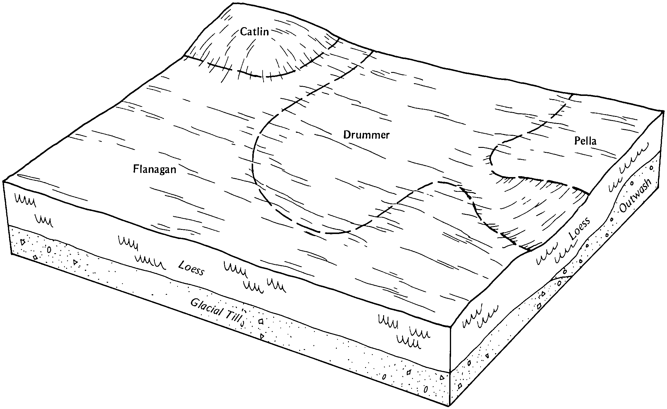
Pella clay loam, Glacial Lake Watseka, 0 to 2 percent slopes | 153A | 23038 | 198332 | 2smzp | il053 | 2001 | 1:12000 |
Pella silty clay loam, 0 to 2 percent slopes | 153A | 2902 | 244660 | 2smzn | il073 | 2001 | 1:12000 |
Pella clay loam, Glacial Lake Watseka, 0 to 2 percent slopes | 153A | 42262 | 175551 | 2smzp | il075 | 1980 | 1:15840 |
Pella silty clay loam, 0 to 2 percent slopes | 153A | 8681 | 977644 | 2smzn | il091 | 2003 | 1:12000 |
Pella silty clay loam, 0 to 2 percent slopes, bedrock substratum | 44A | 317 | 1868862 | 20qpw | il093 | 2007 | 1:12000 |
Pella silty clay loam, 0 to 2 percent slopes | 153A | 14174 | 634362 | 2smzn | il097 | 2003 | 1:12000 |
Pella silt loam, 0 to 2 percent slopes, overwash | 153A+ | 456 | 777275 | v2td | il097 | 2003 | 1:12000 |
Pella silty clay loam, 0 to 2 percent slopes | 153A | 2096 | 176934 | 2smzn | il105 | 1991 | 1:15840 |
Pella silty clay loam, cool, 0 to 2 percent slopes | 153A | 20872 | 182436 | 2tjw5 | il111 | 1997 | 1:12000 |
Pella silt loam, 0 to 2 percent slopes, overwash | 153A+ | 1479 | 182437 | 63v2 | il111 | 1997 | 1:12000 |
Pella silty clay loam, 0 to 2 percent slopes, undrained | 1153A | 928 | 182367 | 63rt | il111 | 1997 | 1:12000 |
Pella silty clay loam, 0 to 2 percent slopes | 153A | 2248 | 1913938 | 2smzn | il115 | 2007 | 1:12000 |
Pella silty clay loam, 0 to 2 percent slopes | 153A | 1272 | 177763 | 2smzn | il125 | 1989 | 1:15840 |
Pella silty clay loam, 0 to 2 percent slopes | 153A | 7263 | 1910896 | 2smzn | il147 | 2009 | 1:12000 |
Pella silty clay loam, 0 to 2 percent slopes | 153A | 2925 | 1612758 | 2smzn | il183 | 2006 | 1:12000 |
Pella silty clay loam, 0 to 2 percent slopes | 153A | 8626 | 262414 | 2smzn | il197 | 2002 | 1:12000 |
Pella silty clay loam | Pk | 1379 | 165222 | 5jxr | in015 | 1987 | 1:15840 |
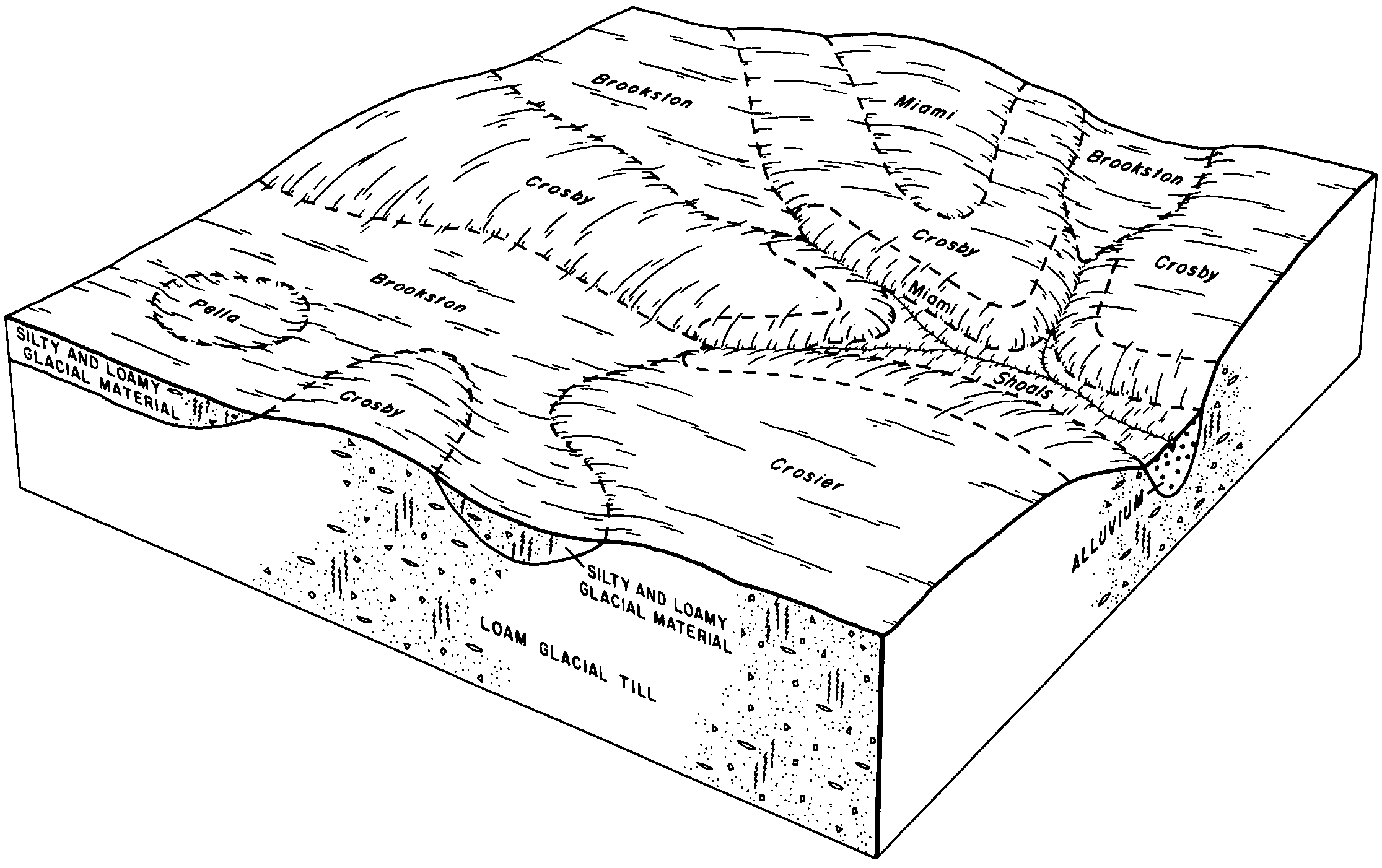
Pella, sandy substratum-Drummer, till substratum, silty clay loams | Ps | 86 | 3291276 | 5fqw | in023 | 1978 | 1:20000 |
Pella silty clay loam, 0 to 1 percent slopes | PgaA | 3768 | 164940 | 5jmn | in035 | 1997 | 1:12000 |
Pella silty clay loam, 0 to 1 percent slopes | PgaA | 1007 | 242398 | 8479 | in045 | 1999 | 1:12000 |
Pella silty clay loam | Ph | 581 | 163049 | 5gnn | in107 | 1984 | 1:15840 |
Pella silty clay loam, pothole | Pg | 1507 | 164238 | 5hx0 | in157 | 1990 | 1:15840 |
Pella, sandy substratum-Drummer, till substratum, silty clay loams | Ps | 15221 | 162157 | 5fqw | in159 | 1985 | 1:15840 |
Pella silty clay loam | Pt | 1034 | 161220 | 5drn | in169 | 1980 | 1:15840 |
Pella silty clay loam, till substratum | Pg | 748 | 161267 | 5dt5 | in179 | 1988 | 1:15840 |
Pella mucky silty clay loam, sandy substratum | Pk | 516 | 161268 | 5dt6 | in179 | 1988 | 1:15840 |
Pella silty clay loam | Pa | 11727 | 161863 | 5ffd | in181 | 1979 | 1:20000 |
Pella silty clay loam, till substratum | Ph | 3729 | 161864 | 5fff | in181 | 1979 | 1:20000 |
Pella silt loam | 32 | 7371 | 186171 | 67qj | mi021 | 1979 | 1:15840 |
Pella silt loam | 73 | 1224 | 188725 | 6bcx | mi025 | 1993 | 1:15840 |
Pella silt loam | Pe | 4324 | 186645 | 686t | mi111 | 1976 | 1:15840 |
Pella-Frankenmuth complex, 0 to 4 percent slopes | PdB | 46 | 2673554 | 687x | mi111 | 1976 | 1:15840 |
Pella-Frankenmuth complex, 0 to 4 percent slopes | 57B | 8279 | 186679 | 687x | mi145 | 1991 | 1:15840 |
Pella silt loam | 14 | 3764 | 186660 | 6879 | mi145 | 1991 | 1:15840 |
Pella silt loam | 59 | 433 | 187510 | 693q | mi157 | 1984 | 1:15840 |
Pella silt loam | Pc | 5073 | 191664 | 6ffq | mi161 | 1974 | 1:20000 |
Pella silt loam | Pc | 3242 | 3015059 | 6bkt | mi163 | 1974 | 1:12000 |
Pella silt loam, 0 to 2 percent slopes | 7153A | 408 | 426236 | 2t044 | wi009 | 1970 | 1:20000 |
Pella silt loam, 0 to 2 percent slopes | 7153A | 7061 | 3268506 | 2t044 | wi015 | 2023 | 1:15840 |
Pella silty clay loam, cool, 0 to 2 percent slopes | 7253A | 72358 | 423631 | 2tjw5 | wi027 | 1976 | 1:15840 |
Pella silt loam, bedrock substratum, 0 to 2 percent slopes | 7144A | 129 | 423632 | 2tjyz | wi027 | 1976 | 1:15840 |
Pella silt loam, 0 to 2 percent slopes | 7153A | 40287 | 425543 | 2t044 | wi039 | 1967 | 1:15840 |
Pella silty clay loam, cool, 0 to 2 percent slopes | 7253A | 7886 | 425544 | 2tjw5 | wi039 | 1967 | 1:15840 |
Pella silt loam, 0 to 2 percent slopes | 7153A | 1632 | 3268698 | 2t044 | wi059 | 2023 | 1:15840 |
Pella silt loam, 0 to 2 percent slopes | 7153A | 5237 | 422347 | 2t044 | wi061 | 1978 | 1:15840 |
Pella silt loam, 0 to 2 percent slopes | 7153A | 4636 | 3268592 | 2t044 | wi071 | 2023 | 1:15840 |
Pella silt loam, 0 to 2 percent slopes | 7153A | 299 | 3403338 | 2t044 | wi079 | 2023 | 1:15840 |
Pella silt loam, bedrock substratum, 0 to 2 percent slopes | 7144A | 20 | 3403337 | 2tjyz | wi079 | 2023 | 1:15840 |
Pella silt loam, 0 to 2 percent slopes | 7153A | 4735 | 422588 | 2t044 | wi087 | 1975 | 1:15840 |
Pella silt loam, 0 to 2 percent slopes | 7153A | 1313 | 426010 | 2t044 | wi089 | 1967 | 1:15840 |
Pella silt loam, 0 to 2 percent slopes | 7153A | 2051 | 3403252 | 2t044 | wi101 | 2023 | 1:15840 |
Pella silt loam, 0 to 2 percent slopes | 7153A | 4110 | 423922 | 2t044 | wi117 | 1974 | 1:15840 |
Pella silt loam, 0 to 2 percent slopes | 7153A | 22379 | 425663 | 2t044 | wi127 | 1967 | 1:15840 |
Pella silt loam, 0 to 2 percent slopes | 7153A | 9025 | 425765 | 2t044 | wi131 | 1967 | 1:15840 |
Pella silt loam, 0 to 2 percent slopes | 7153A | 9371 | 3403507 | 2t044 | wi133 | 2023 | 1:15840 |
Pella silt loam, bedrock substratum, 0 to 2 percent slopes | 7144A | 639 | 3403506 | 2tjyz | wi133 | 2023 | 1:15840 |
