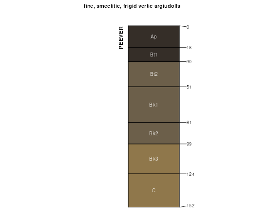
| Peever clay loam, 6 to 12 percent slopes | 646C | 4433 | 435882 | gmkq | mn111 | 1996 | 1:20000 |
Peever-Mehurin complex, 2 to 6 percent slopes | 779B | 3469 | 435949 | gmmw | mn111 | 1996 | 1:20000 |
Peever clay loam, 12 to 18 percent slopes | 646D | 1737 | 435883 | gmkr | mn111 | 1996 | 1:20000 |
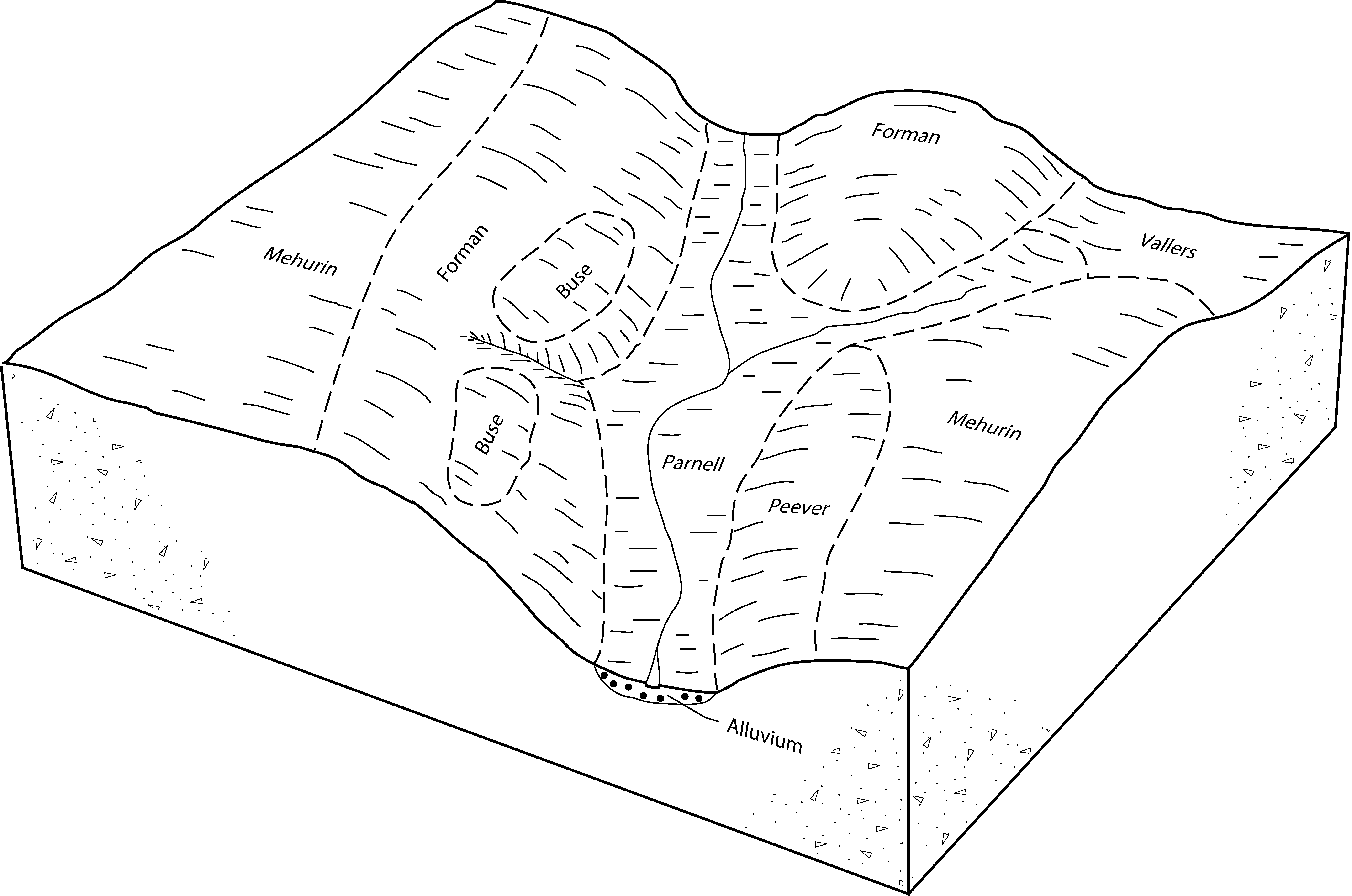
Peever-Buse complex, 2 to 6 percent slopes | 822B | 2115 | 357382 | czwg | mn155 | 1986 | 1:20000 |
Peever clay loam, 2 to 6 percent slopes | 646B | 295 | 357375 | 2w8f7 | mn155 | 1986 | 1:20000 |
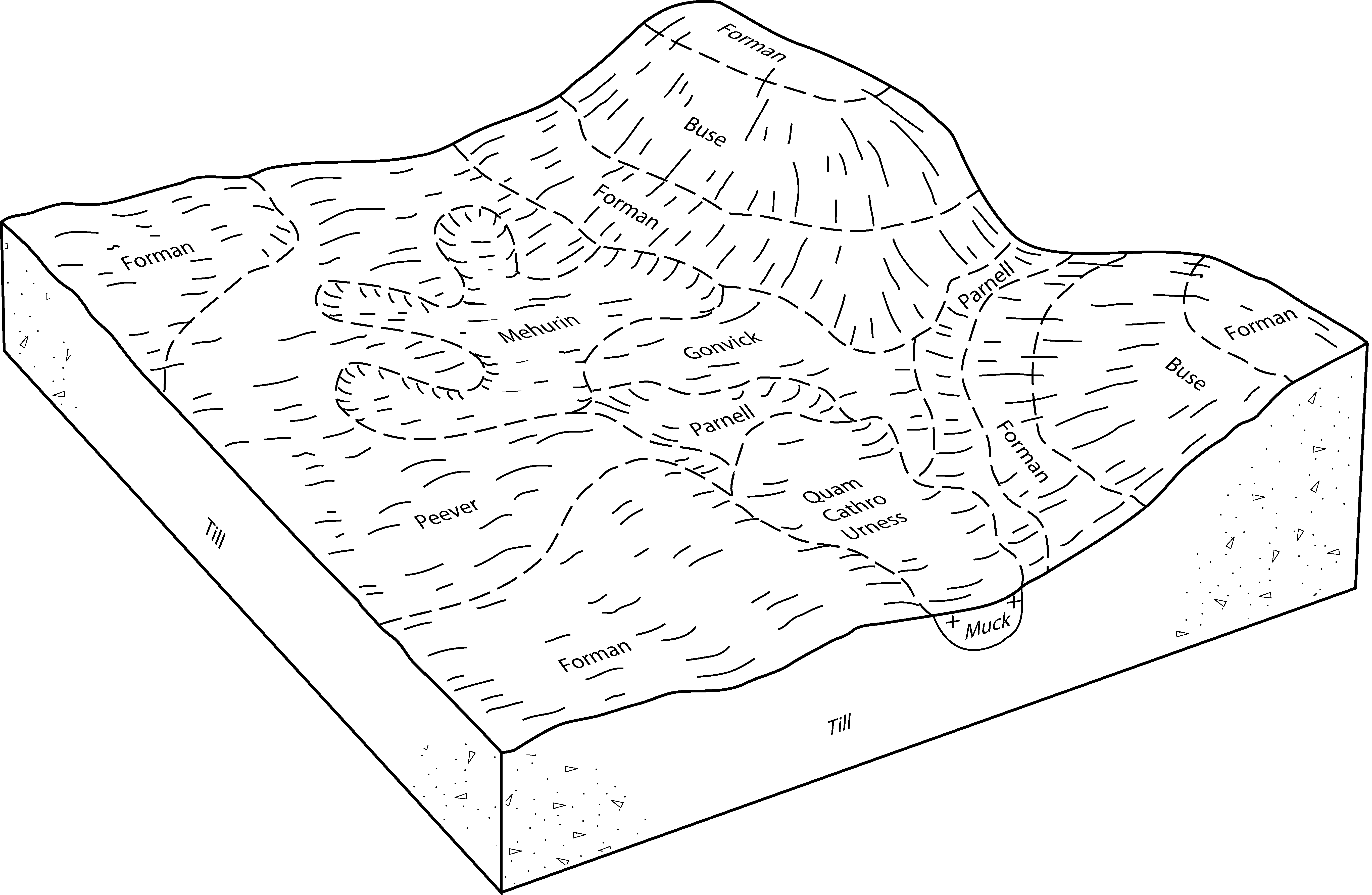
Gwinner-Peever-Parnell complex, 0 to 3 percent slopes | G205A | 10431 | 2581137 | 2pwzz | nd073 | 1992 | 1:20000 |
Peever-Gwinner complex, 3 to 6 percent slopes | G206B | 1745 | 2581138 | 2px01 | nd073 | 1992 | 1:20000 |
Gwinner-Peever complex, 0 to 3 percent slopes | G206A | 166 | 2506014 | 2px00 | nd073 | 1992 | 1:20000 |
Gwinner-Peever complex, 0 to 3 percent slopes | G206A | 3135 | 2577410 | 2px00 | nd077 | 2005 | 1:12000 |
Peever-Forman complex, 0 to 3 percent slopes | G207A | 989 | 2577393 | 2px02 | nd077 | 2005 | 1:12000 |
Forman-Peever complex, 3 to 6 percent slopes | J211B | 963 | 1544942 | 1nvmv | nd077 | 2005 | 1:12000 |
Peever-Gwinner complex, 3 to 6 percent slopes | G206B | 814 | 2577418 | 2px01 | nd077 | 2005 | 1:12000 |
Gwinner-Peever complex, 0 to 3 percent slopes | J213A | 95 | 1544944 | 1nvmx | nd077 | 2005 | 1:12000 |
Gwinner-Peever complex, 0 to 3 percent slopes | G206A | 13671 | 2579486 | 2px00 | nd081 | 1959 | 1:12000 |
Gwinner-Peever-Parnell complex, 0 to 3 percent slopes | G205A | 9647 | 2579458 | 2pwzz | nd081 | 1959 | 1:12000 |
Peever-Gwinner complex, 3 to 6 percent slopes | G206B | 105 | 2579513 | 2px01 | nd081 | 1959 | 1:12000 |
Peever-Buse clay loams, 1 to 6 percent slopes | G208B | 1391 | 2797745 | 2sd22 | sd013 | 1987 | 1:20000 |
Peever clay loam, 0 to 3 percent slopes | G204A | 669 | 2797744 | 2sd20 | sd013 | 1987 | 1:20000 |
Peever-Cavour complex, 0 to 3 percent slopes | G202A | 58 | 2797743 | 2sd1y | sd013 | 1987 | 1:20000 |
Peever clay loam, 0 to 3 percent slopes | G204A | 2091 | 2798008 | 2sd20 | sd025 | 1992 | 1:20000 |
Peever-Cavour complex, 0 to 3 percent slopes | G202A | 1956 | 2798006 | 2sd1y | sd025 | 1992 | 1:20000 |
Peever-Cresbard-Tonka complex, 0 to 3 percent slopes | G203A | 1669 | 2798007 | 2sd1z | sd025 | 1992 | 1:20000 |
Peever clay loam, 3 to 6 percent slopes | G204B | 569 | 2798009 | 2sd21 | sd025 | 1992 | 1:20000 |
Peever clay loam, 0 to 2 percent slopes | PcA | 2158 | 2947369 | 2w8f6 | sd039 | 1992 | 1:20000 |
Peever clay loam, coteau, 2 to 6 percent slopes | PeB | 1238 | 416887 | fzsz | sd039 | 1992 | 1:20000 |
Peever clay loam, 2 to 6 percent slopes | PcB | 1106 | 2947367 | 2w8f7 | sd039 | 1992 | 1:20000 |
Peever-Cavour clay loams | Pg | 352 | 416888 | fzt0 | sd039 | 1992 | 1:20000 |
Peever clay loam, coteau, 0 to 2 percent slopes | PeA | 127 | 416886 | fzsy | sd039 | 1992 | 1:20000 |
Peever clay loam, 0 to 2 percent slopes | PeA | 24984 | 2947370 | 2w8f6 | sd051 | 1977 | 1:20000 |
Peever clay loam, 2 to 6 percent slopes | PeB | 21652 | 2947368 | 2w8f7 | sd051 | 1977 | 1:20000 |
Peever-Cavour complex | Pd | 17790 | 418174 | g14h | sd051 | 1977 | 1:20000 |
Peever clay loam, coteau, 2 to 6 percent slopes | PcB | 6107 | 418172 | g14f | sd051 | 1977 | 1:20000 |
Peever clay loam, 6 to 9 percent slopes | PcC | 4691 | 418173 | g14g | sd051 | 1977 | 1:20000 |
Peever-Tonka complex | Pe | 1130 | 418175 | g14j | sd051 | 1977 | 1:20000 |
Peever clay loam, coteau, 0 to 2 percent slopes | PcA | 602 | 418171 | g14d | sd051 | 1977 | 1:20000 |
Peever clay loam, 2 to 6 percent slopes | PeB | 6281 | 416591 | 2w8f7 | sd091 | 1970 | 1:20000 |
Peever clay loam, 0 to 2 percent slopes | PeA | 3890 | 416590 | 2w8f6 | sd091 | 1970 | 1:20000 |
Peever-Hamerly complex, 0 to 2 percent slopes | PhA | 3260 | 416593 | fzhh | sd091 | 1970 | 1:20000 |
Peever clay loam, 6 to 9 percent slopes | PeC | 490 | 416592 | fzhg | sd091 | 1970 | 1:20000 |
Gwinner-Peever complex, 0 to 3 percent slopes | G206A | 117 | 2799276 | 2px00 | sd091 | 1970 | 1:20000 |
Peever-Gwinner complex, 3 to 6 percent slopes | G206B | 11 | 2799277 | 2px01 | sd091 | 1970 | 1:20000 |
Peever clay loam, 2 to 6 percent slopes | PeB | 50065 | 417854 | 2w8f7 | sd109 | 1977 | 1:20000 |
Peever clay loam, 0 to 2 percent slopes | PeA | 33587 | 417853 | 2w8f6 | sd109 | 1977 | 1:20000 |
Peever-Tonka complex | Pk | 17824 | 417857 | g0t8 | sd109 | 1977 | 1:20000 |
Peever clay loam, 6 to 9 percent slopes | PeC | 4382 | 417855 | g0t6 | sd109 | 1977 | 1:20000 |
Peever-Cavour complex, 0 to 3 percent slopes | PhA | 1655 | 417856 | g0t7 | sd109 | 1977 | 1:20000 |
Peever-Buse clay loams, 1 to 6 percent slopes | G208B | 1009 | 2799589 | 2sd22 | sd115 | 1997 | 1:24000 |
Peever-Cavour complex, 0 to 3 percent slopes | G202A | 740 | 2799586 | 2sd1y | sd115 | 1997 | 1:24000 |
Peever-Cresbard-Tonka complex, 0 to 3 percent slopes | G203A | 517 | 2799587 | 2sd1z | sd115 | 1997 | 1:24000 |
Peever clay loam, 0 to 3 percent slopes | G204A | 201 | 2799588 | 2sd20 | sd115 | 1997 | 1:24000 |


