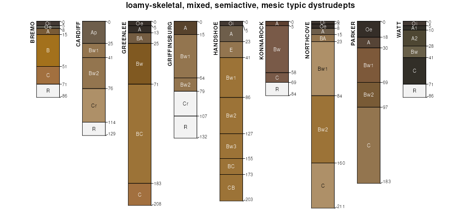
| Parker gravelly loam, 8 to 25 percent slopes, very stony | PaD | 1 | 3347301 | 2zhhq | de003 | 2009 | 1:24000 |
Parker gravelly loam, 25 to 55 percent slopes, very stony | PaF | 1 | 3347302 | 2zhhp | de003 | 2009 | 1:24000 |
Parker cobbly loam, 18 to 40 percent slopes, extremely stony | ParEe | 13867 | 1482827 | 1ls04 | nj019 | 1970 | 1:24000 |
Parker cobbly loam, 3 to 15 percent slopes | ParC | 9805 | 548645 | ldx7 | nj019 | 1970 | 1:24000 |
Gladstone and Parker soils, 8 to 15 percent slopes, extremely stony | GKAPCC | 6268 | 1033913 | 13pw1 | nj019 | 1970 | 1:24000 |
Parker cobbly loam, 15 to 25 percent slopes | ParD | 3904 | 548646 | ldx8 | nj019 | 1970 | 1:24000 |
Parker-Gladstone complex, 0 to 15 percent slopes, extremely stony | PauCc | 15700 | 1480285 | 1lpc4 | nj027 | 1974 | 1:24000 |
Parker gravelly sandy loam, 3 to 15 percent slopes | PaoC | 8677 | 298520 | b0mp | nj027 | 1974 | 1:24000 |
Parker-Gladstone complex, 15 to 25 percent slopes, extremely stony | PauDc | 8613 | 1480286 | 1lpc5 | nj027 | 1974 | 1:24000 |
Parker-Rock outcrop complex, 25 to 45 percent slopes | PawE | 6444 | 298524 | b0mt | nj027 | 1974 | 1:24000 |
Parker very gravelly sandy loam, 15 to 25 percent slopes | PapD | 2434 | 298521 | b0mq | nj027 | 1974 | 1:24000 |
Parker cobbly loam, 3 to 15 percent slopes | ParC | 310 | 1482962 | 1ls4h | nj027 | 1974 | 1:24000 |
Gladstone and Parker soils, 8 to 15 percent slopes, extremely stony | GKAPCC | 200 | 1482960 | 1ls4f | nj027 | 1974 | 1:24000 |
Parker cobbly loam, 18 to 40 percent slopes, extremely stony | ParEe | 133 | 1482963 | 1ls4j | nj027 | 1974 | 1:24000 |
Parker cobbly loam, 15 to 25 percent slopes | ParD | 52 | 1482964 | 1ls4k | nj027 | 1974 | 1:24000 |
Parker-Gladstone complex, 15 to 25 percent slopes, very stony | PauDb | 1201 | 1034040 | 13q04 | nj035 | 1972 | 1:24000 |
Parker very gravelly sandy loam, 3 to 15 percent slopes | PapC | 980 | 548506 | ldrr | nj035 | 1972 | 1:24000 |
Parker very gravelly sandy loam, 25 to 45 percent slopes, rocky | PapFg | 449 | 548504 | ldrp | nj035 | 1972 | 1:24000 |
Parker very gravelly sandy loam, 15 to 25 percent slopes | PapD | 142 | 1405063 | 1j52m | nj035 | 1972 | 1:24000 |
Parker-Gladstone complex, 15 to 25 percent slopes, extremely stony | PauDc | 81 | 1034041 | 13q05 | nj035 | 1972 | 1:24000 |
Parker-Gladstone complex, 0 to 15 percent slopes, extremely stony | PauCc | 64 | 1034034 | 13pzy | nj035 | 1972 | 1:24000 |
Parker-Rock outcrop complex, 25 to 45 percent slopes | PawE | 55 | 548555 | ldtb | nj035 | 1972 | 1:24000 |
Parker gravelly sandy loam, 3 to 15 percent slopes | PaoC | 12 | 548505 | ldrq | nj035 | 1972 | 1:24000 |
Parker-Rock outcrop complex, 45 to 65 percent slopes | PawF | 7487 | 1896061 | 21n08 | nj041 | 2007 | 1:12000 |
Parker gravelly sandy loam, 15 to 25 percent slopes | PaoD | 4487 | 298375 | b0h0 | nj041 | 2007 | 1:12000 |
Parker-Rock outcrop complex, 25 to 45 percent slopes | PawE | 1010 | 1896062 | 21n09 | nj041 | 2007 | 1:12000 |
Parker gravelly sandy loam, 3 to 15 percent slopes | PaoC | 96 | 1710223 | 1vdmh | nj041 | 2007 | 1:12000 |
Gladstone-Parker gravelly loams, 15 to 25 percent slopes | GnD | 66 | 1947960 | 23d0f | pa017 | 1997 | 1:24000 |
Gladstone-Parker gravelly loams, 15 to 25 percent slopes | GeD | 4103 | 1599929 | 1qpvm | pa029 | 2008 | 1:24000 |
Parker gravelly loam, 8 to 15 percent slopes | PaC | 3161 | 868631 | y4wc | pa029 | 2008 | 1:24000 |
Parker gravelly loam, 15 to 25 percent slopes | PaD | 2910 | 868630 | y4wb | pa029 | 2008 | 1:24000 |
Parker gravelly loam, 25 to 35 percent slopes | PaE | 1780 | 868629 | y4w9 | pa029 | 2008 | 1:24000 |
Parker gravelly loam, 3 to 8 percent slopes | PaB | 1044 | 868632 | y4wd | pa029 | 2008 | 1:24000 |
Parker gravelly loam, 35 to 60 percent slopes | PaF | 551 | 868860 | y53r | pa029 | 2008 | 1:24000 |
Parker loam, 8 to 25 percent slopes, extremely stony | PbD | 385 | 868627 | y4w7 | pa029 | 2008 | 1:24000 |
Parker loam, 25 to 60 percent slopes, extremely stony | PbF | 164 | 868626 | y4w6 | pa029 | 2008 | 1:24000 |
Parker loam, 0 to 8 percent slopes, extremely stony | PbB | 82 | 868628 | y4w8 | pa029 | 2008 | 1:24000 |
Urban land-Parker complex, 8 to 25 percent slopes | UrvD | 79 | 1611965 | 1r3cw | pa029 | 2008 | 1:24000 |
Urban land-Parker complex, 0 to 8 percent slopes | UrvB | 22 | 1611964 | 1r3cv | pa029 | 2008 | 1:24000 |
Parker gravelly loam, 25 to 35 percent slopes | PbE | 585 | 984449 | 2zhhh | pa045 | 2023 | 1:12000 |
Gladstone-Parker complex, 0 to 8 percent slopes | GfB | 288 | 2396182 | 30chb | pa045 | 2023 | 1:12000 |
Parker gravelly loam, 15 to 25 percent slopes | PbD | 263 | 984446 | 2yh31 | pa045 | 2023 | 1:12000 |
Parker gravelly loam, 8 to 25 percent slopes, very stony | PaD | 245 | 984451 | 2zhhq | pa045 | 2023 | 1:12000 |
Parker gravelly loam, 25 to 55 percent slopes, very stony | PaF | 169 | 984452 | 2zhhp | pa045 | 2023 | 1:12000 |
Parker gravelly loam, 8 to 15 percent slopes | PbC | 120 | 984443 | 2zhhk | pa045 | 2023 | 1:12000 |
Parker gravelly loam, 3 to 8 percent slopes | PbB | 41 | 984442 | 2zhhj | pa045 | 2023 | 1:12000 |
Parker gravelly loam, 0 to 8 percent slopes, very stony | PaB | 3 | 984450 | 2zhhn | pa045 | 2023 | 1:12000 |
Gladstone-Parker gravelly loams, 15 to 25 percent slopes | GgD | 24 | 1947970 | 23d0r | pa077 | 1997 | 1:24000 |
Parker gravelly loam, 8 to 15 percent slopes | PaC | 614 | 2397962 | 2lh8m | pa091 | 2008 | 1:12000 |
Parker loam, 8 to 25 percent slopes, extremely stony | PbD | 531 | 2397968 | 2lh8t | pa091 | 2008 | 1:12000 |
Parker gravelly loam, 25 to 35 percent slopes | PaE | 360 | 2397965 | 2lh8q | pa091 | 2008 | 1:12000 |
Parker gravelly loam, 15 to 25 percent slopes | PaD | 297 | 2397964 | 2lh8p | pa091 | 2008 | 1:12000 |
Parker loam, 25 to 60 percent slopes, extremely stony | PbF | 226 | 2397969 | 2lh8v | pa091 | 2008 | 1:12000 |
Parker gravelly loam, 3 to 8 percent slopes | PaB | 196 | 2397961 | 2lh8l | pa091 | 2008 | 1:12000 |
Parker loam, 0 to 8 percent slopes, extremely stony | PbB | 50 | 2397966 | 2lh8r | pa091 | 2008 | 1:12000 |
Gladstone-Parker gravelly loams, 15 to 25 percent slopes | GnD | 1888 | 1946672 | 23bnw | pa095 | 2007 | 1:12000 |
Parker very stony loam, 25 to 45 percent slopes | 66E | 12580 | 516440 | kbdc | va003 | 1981 | 1:15840 |
Parker extremely stony loam, 25 to 60 percent slopes | 67E | 6100 | 516442 | kbdf | va003 | 1981 | 1:15840 |
Parker very stony loam, 15 to 25 percent slopes | 66D | 2320 | 516439 | kbdb | va003 | 1981 | 1:15840 |
Parker very stony loam, 7 to 15 percent slopes | 66C | 700 | 516438 | kbd9 | va003 | 1981 | 1:15840 |
Parker extremely stony loam, 15 to 25 percent slopes | 67D | 550 | 516441 | kbdd | va003 | 1981 | 1:15840 |
Parker extremely stony loam, 25 to 70 percent slopes | PrE | 14348 | 516905 | kbwc | va079 | 1983 | 1:15840 |
Chester and Parker soils, very stony, 15 to 25 percent slopes | CmD | 2877 | 516882 | kbvm | va079 | 1983 | 1:15840 |
Chester and Parker soils, very stony, 7 to 15 percent slopes | CmC | 620 | 516881 | kbvl | va079 | 1983 | 1:15840 |
Parker-Glenelg complex, 25 to 50 percent slopes | 26E | 4498 | 517100 | kc2n | va121 | 1980 | 1:15840 |
Parker-Glenelg complex, 15 to 25 percent slopes | 26D | 1371 | 517099 | kc2m | va121 | 1980 | 1:15840 |
Parker-Rock outcrop complex, 25 to 50 percent slopes | 27E | 1027 | 517101 | kc2p | va121 | 1980 | 1:15840 |
Parker-Glenelg complex, 7 to 15 percent slopes | 26C | 759 | 517098 | kc2l | va121 | 1980 | 1:15840 |