| Wet loamy alluvial land | Wm | 41030 | 328224 | c0jw | al003 | 1961 | 1:20000 |
Johnston, Bibb and Pamlico soils, 0 to 1 percent slopes, frequently flooded | JBA | 36222 | 2995061 | 2x5qy | al097 | 2018 | 1:24000 |
Johnston, Pamlico and Dorovan soils, 0 to 1 percent slopes, frequently flooded | JPA | 15860 | 2995021 | 2x5q8 | al097 | 2018 | 1:24000 |
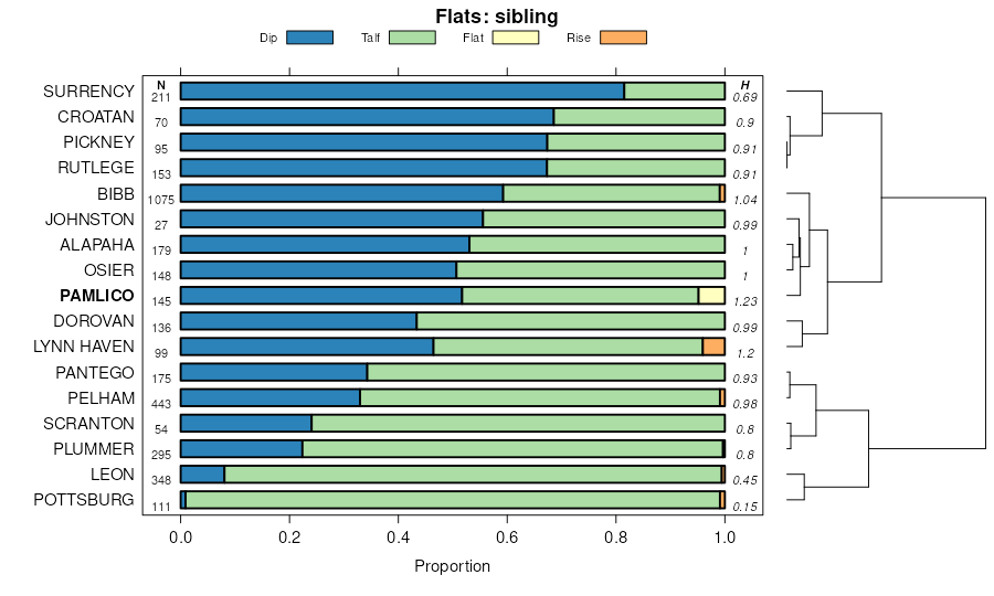
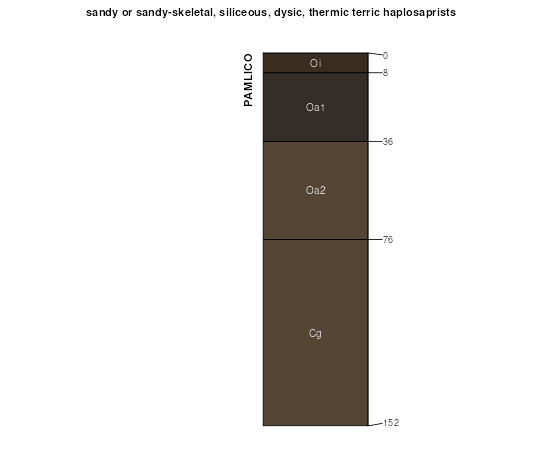
Pamlico muck, frequently flooded | 85 | 736 | 320791 | brt3 | fl001 | 1982 | 1:15840 |
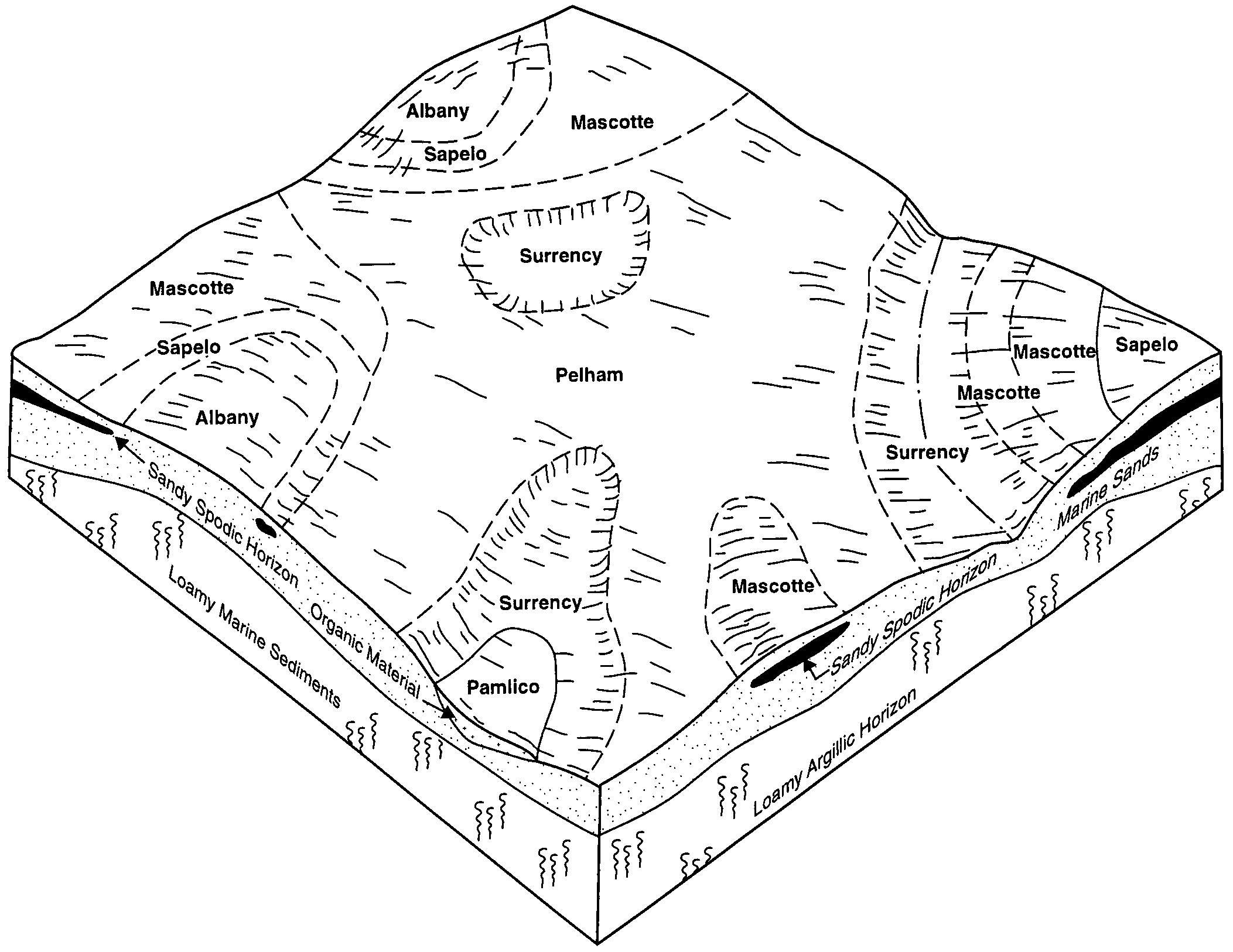
Pantego-Pamlico, loamy substratum, complex, depressional | 36 | 67175 | 1444894 | 1khjh | fl003 | 1991 | 1:20000 |
Pamlico muck, loamy substratum, depressional | 40 | 25155 | 1444898 | 1khjm | fl003 | 1991 | 1:20000 |
Mascotte-Pamlico complex, loamy substratum, ponded, 0 to 1 percent slopes | 52 | 17620 | 1444909 | 2tzkj | fl003 | 1991 | 1:20000 |
Rutlege-Pamlico complex | 51 | 29959 | 320839 | brvn | fl005 | 1982 | 1:20000 |
Pamlico-Dorovan complex | 22 | 28497 | 320810 | brtq | fl005 | 1982 | 1:20000 |
Pamlico and Croatan mucks | 14 | 5126 | 631626 | p681 | fl007 | 1988 | 1:15840 |
Pamlico and Croatan mucks, frequently flooded | 37 | 2550 | 631644 | p68m | fl007 | 1988 | 1:15840 |
Pamlico, Bibb, and Rutlege soils, frequently flooded | 64 | 11563 | 1481049 | 1lq4s | fl013 | 1997 | 1:20000 |
Dorovan-Pamlico-Rutlege association, depressional | 20 | 3026 | 1481002 | 1lq38 | fl013 | 1997 | 1:20000 |
Pamlico muck, frequently flooded | 43 | 4030 | 132833 | 4g6y | fl019 | 1986 | 1:24000 |
Pamlico muck | 27 | 3365 | 132817 | 4g6f | fl019 | 1986 | 1:24000 |
Plummer, depressional-Pamlico, loamy substratum complex | 55 | 28470 | 797478 | vrv3 | fl023 | 1981 | 1:24000 |
Pamlico muck, loamy substratum | 45 | 8120 | 797467 | vrtr | fl023 | 1981 | 1:24000 |
Pamlico, loamy substratum-Dorovan complex | 46 | 3240 | 797468 | vrts | fl023 | 1981 | 1:24000 |
Pamlico muck, depressional, 0 to 1 percent slopes | 49 | 3720 | 738861 | ssv7 | fl031 | 1996 | 1:24000 |
Pamlico muck, 0 to 2 percent slopes, frequently flooded | 50 | 540 | 738862 | ssv8 | fl031 | 1996 | 1:24000 |
Pickney-Pamlico complex, depressional | 36 | 16813 | 1477089 | 1ll11 | fl037 | 1990 | 1:20000 |
Pamlico-Pickney complex, 0 to 1 percent slopes, frequently flooded | 41 | 8255 | 1477095 | 2ttlq | fl037 | 1990 | 1:20000 |
Dorovan-Pamlico complex, depressional | 11 | 3198 | 1477062 | 1ll05 | fl037 | 1990 | 1:20000 |
Pamlico-Dorovan mucks, frequently flooded | 20 | 4075 | 321803 | bsvr | fl041 | 1989 | 1:20000 |
Pickney-Pamlico complex, depressional | 31 | 13433 | 1472752 | 1lfj4 | fl045 | 1997 | 1:24000 |
Pamlico-Pickney complex, 0 to 1 percent slopes, frequently flooded | 44 | 2685 | 1472764 | 2ttlq | fl045 | 1997 | 1:24000 |
Pamlico muck, depressional | 20 | 19750 | 1148816 | 17kfl | fl047 | 1995 | 1:24000 |
Pamlico-Pantego-Rutlege association | 48 | 12450 | 1424953 | 1jts7 | fl063 | 1977 | 1:20000 |
Dorovan-Pamlico association | 16 | 7290 | 1424918 | 1jtr3 | fl063 | 1977 | 1:20000 |
Pamlico-Dorovan mucks | 30 | 13150 | 700491 | rhxh | fl065 | 1984 | 1:20000 |
Pamlico and Dorovan soils, depressional | 11 | 41600 | 886564 | yrjv | fl067 | 1993 | 1:24000 |
Pamlico and Dorovan soils, frequently flooded | 10 | 400 | 886563 | yrjt | fl067 | 1993 | 1:24000 |
Pamlico-Dorovan complex | 38 | 3730 | 1454447 | 1ktgn | fl073 | 1989 | 1:20000 |
Dorovan-Pamlico complex, depressional | 13 | 1215 | 322699 | btsn | fl077 | 2004 | 1:24000 |
Pamlico-Pickney complex, 0 to 1 percent slopes, frequently flooded | 92 | 730 | 653993 | 2ttlq | fl077 | 2004 | 1:24000 |
Dorovan and Pamlico soils, depressional | 74 | 80020 | 1380340 | 1hbc3 | fl079 | 1988 | 1:15840 |
Dorovan-Pamlico association | 7 | 17120 | 823754 | wn5q | fl113 | 1978 | 1:20000 |
Pamlico-Olustee-Pottsburg complex, depressional | 46 | 8354 | 1023360 | 13bwm | fl121 | 2003 | 1:24000 |
Dorovan and Pamlico soils, depressional | 30 | 58860 | 1425224 | 1jv1z | fl123 | 1998 | 1:24000 |
Wesconnett, Evergreen and Pamlico soils, frequently ponded, 0 to 2 percent slopes | 33 | 33060 | 1425230 | 2y51p | fl123 | 1998 | 1:24000 |
Pamlico and Croatan mucks | 14 | 8470 | 1414578 | 1jgzk | fl125 | 1989 | 1:15840 |
Pamlico and Croatan mucks, frequently flooded | 37 | 2860 | 1414602 | 1jh0b | fl125 | 1989 | 1:15840 |
Dorovan-Pamlico association, frequently flooded | 8 | 41510 | 324047 | bw64 | fl131 | 1985 | 1:20000 |
Pamlico muck | 64 | 6920 | 324037 | bw5t | fl131 | 1985 | 1:20000 |
Rutlege, Pickney and Pamlico soils, frequently flooded | 2 | 33670 | 1719191 | 1vpys | fl133 | 2009 | 1:12000 |
Sellers and Pamlico soils | Sp | 7935 | 640602 | phll | fl609 | 1968 | 1:24000 |
Pamlico muck, deep | Pd | 1114 | 640593 | phl9 | fl609 | 1968 | 1:24000 |
Pamlico muck | Pa | 343 | 640592 | phl8 | fl609 | 1968 | 1:24000 |
Croatan, Pamlico, and Surrency soils, ponded, 0 to 1 percent slopes, rarely flooded | CPA | 24670 | 2408351 | 2lv2r | ga299 | 2008 | 1:24000 |
Pantego-Pamlico, loamy substratum complex, ponded, 0 to 1 percent slopes | PgA | 645 | 2408372 | 2lv3f | ga299 | 2008 | 1:24000 |
Mascotte-Pamlico complex, loamy substratum, ponded, 0 to 1 percent slopes | MoA | 265 | 2408367 | 2tzkj | ga299 | 2008 | 1:24000 |
Pamlico muck, loamy substratum, ponded, 0 to 1 percent slopes | PaA | 235 | 2408371 | 2lv3d | ga299 | 2008 | 1:24000 |
Croatan, Pamlico and Surrency soils, ponded, 0 to 1 percent slopes, rarely flooded | CPA | 10775 | 2686754 | 2rz85 | ga611 | 2012 | 1:24000 |
Pantego-Pamlico complex, loamy substratum, ponded, 0 to 1 percent slopes | PgA | 110 | 2686794 | 2rz9h | ga611 | 2012 | 1:24000 |
Croatan, Pamlico and Surrency soils, ponded, 0 to 1 percent slopes, rarely flooded | CPA | 11339 | 2686802 | 2rz85 | ga626 | 2013 | 1:24000 |
Pamlico-Dorovan association (croatan-dorovan) | PD | 10548 | 332228 | c4q1 | ms035 | 1976 | 1:20000 |
Pamlico muck, rarely flooded | Pa | 34034 | 115506 | 3w60 | nc017 | 1983 | 1:24000 |
Pamlico muck, frequently flooded | PC | 896 | 115507 | 3w61 | nc017 | 1983 | 1:24000 |
Johnston and Pamlico soils, 0 to 1 percent slopes, frequently flooded | JpA | 2624 | 1865968 | 20mpj | nc061 | 1955 | 1:24000 |
Pamlico muck | Pc | 4792 | 116018 | 3wqj | nc107 | 1973 | 1:20000 |
Pamlico muck | Pm | 931 | 116052 | 3wrm | nc129 | 1974 | 1:15840 |
Pamlico muck | Pm | 1533 | 115068 | 3vqw | nc163 | 1982 | 1:24000 |
Pamlico and Johnston soils, 0 to 1 percent slopes, frequently flooded | PcA | 8013 | 1414621 | 1jh0y | nc165 | 2006 | 1:12000 |
Pamlico muck | Pa | 1116 | 116259 | 3wz9 | nc191 | 1968 | 1:20000 |
Pamlico muck | Pa | 4590 | 131966 | 4f9z | sc015 | 1974 | 1:20000 |
Pamlico muck, 0 to 2 percent slopes,frequently flooded | PaA | 936 | 620355 | ntjg | sc031 | 1998 | 1:24000 |
Pamlico muck, frequently flooded | Pa | 9662 | 130658 | 4cys | sc069 | 1995 | 1:24000 |
Pamlico muck | Pa | 5102 | 138293 | 4mx2 | sc690 | 1967 | 1:24000 |
Rutlege-Pamlico complex | Rp | 2541 | 138298 | 4mx7 | sc690 | 1967 | 1:24000 |
Pamlico and Portsmouth soils | 25 | 365 | 118958 | 3zsc | va073 | 1978 | 1:15840 |
Pamlico mucky peat, ponded | 26 | 1095 | 120902 | 41t2 | va810 | 1982 | 1:15840 |
Pamlico-Lakehurst variant complex | 27 | 750 | 120903 | 41t3 | va810 | 1982 | 1:15840 |