Official Series Description


Lab Data Summary

Aggregate lab data for the PALOUSE soil series. This aggregation is based on all pedons with a current taxon name of PALOUSE, and applied along 1-cm thick depth slices. Solid lines are the slice-wise median, bounded on either side by the interval defined by the slice-wise 5th and 95th percentiles. The median is the value that splits the data in half. Five percent of the data are less than the 5th percentile, and five percent of the data are greater than the 95th percentile. Values along the right hand side y-axis describe the proportion of pedon data that contribute to aggregate values at this depth. For example, a value of "90%" at 25cm means that 90% of the pedons correlated to PALOUSE were used in the calculation. Source: KSSL snapshot . Methods used to assemble the KSSL snapshot used by SoilWeb / SDE

Click the image to view it full size.

Pedons used in the lab summary:

MLRALab IDPedon IDTaxonnameCINSSL / NASIS ReportsLink To SoilWeb GMap
977-ID-29851977ID057009Palouse5Primary | Supplementary | Taxonomy | Pedon | Water Retention | Correlation | Andic Soil Properties46.5555139,-116.8021222
977-ID-297977ID057011Palouse5Primary | Supplementary | Taxonomy | Pedon | Water Retention | Correlation | Andic Soil Properties46.7205,-116.9516
978P010777WA075001Palouse6Primary | Supplementary | Taxonomy | Pedon | Water Retention | Correlation | Andic Soil Properties46.671831,-117.1377451
981P003380WA075001Palouse7Primary | Supplementary | Taxonomy | Pedon | Water Retention | Correlation | Andic Soil Properties46.671831,-117.1377451
986P007085WA075008Palouse7Primary | Supplementary | Taxonomy | Pedon | Water Retention | Correlation | Andic Soil Properties46.9894447,-117.4738922
986P007185WA075009Palouse7Primary | Supplementary | Taxonomy | Pedon | Water Retention | Correlation | Andic Soil Properties46.8913879,-117.0722198
940A0951S1949OR059003PALOUSE3Primary | Supplementary | Taxonomy | Pedon | Water Retention | Correlation | Andic Soil Properties45.7919426,-118.4369431
940A1027S1951WA071005Palouse3Primary | Supplementary | Taxonomy | Pedon | Water Retention | Correlation | Andic Soil Properties46.0483322,-118.160553
904N0220S2002ID009002Palouse6Primary | Supplementary | Taxonomy | Pedon | Water Retention | Correlation | Andic Soil Properties47.1930542,-116.9991684
904N1104S2004ID009002Palouse7Primary | Supplementary | Taxonomy | Pedon | Water Retention | Correlation | Andic Soil Properties47.1866684,-117.0144424
n/a87P049687WA075001Palouse7Primary | Supplementary | Taxonomy | Pedon | Water Retention | Correlation | Andic Soil Propertiesn/a
n/a69C0053S1971WA001200PALOUSEn/aPrimary | Supplementary | Taxonomy | Pedon | Water Retention | Correlation | Andic Soil Propertiesn/a
n/a89P0122S1987WA075001GPalouse7Primary | Supplementary | Taxonomy | Pedon | Water Retention | Correlation | Andic Soil Propertiesn/a

Water Balance

Monthly water balance estimated using a leaky-bucket style model for the PALOUSE soil series. Monthly precipitation (PPT) and potential evapotranspiration (PET) have been estimated from the 50th percentile of gridded values (PRISM 1981-2010) overlapping with the extent of SSURGO map units containing each series as a major component. Monthly PET values were estimated using the method of Thornthwaite (1948). These (and other) climatic parameters are calculated with each SSURGO refresh and provided by the fetchOSD function of the soilDB package. Representative water storage values (“AWC” in the figures) were derived from SSURGO by taking the 50th percentile of profile-total water storage (sum[awc_r * horizon thickness]) for each soil series. Note that this representation of “water storage” is based on the average ability of most plants to extract soil water between 15 bar (“permanent wilting point”) and 1/3 bar (“field capacity”) matric potential. Soil moisture state can be roughly interpreted as “dry” when storage is depleted, “moist” when storage is between 0mm and AWC, and “wet” when there is a surplus. Clearly there are a lot of assumptions baked into this kind of monthly water balance. This is still a work in progress.

Click the image to view it full size.


Click the image to view it full size.

Sibling Summary

Siblings are those soil series that occur together in map units, in this case with the PALOUSE series. Sketches are arranged according to their subgroup-level taxonomic structure. Source: SSURGO snapshot , parsed OSD records and snapshot of SC database .

Click the image to view it full size.

Select annual climate data summaries for the PALOUSE series and siblings. Series are sorted according to hierarchical clustering of median values. Source: SSURGO map unit geometry and 1981-2010, 800m PRISM data .

Click the image to view it full size.

Geomorphic description summaries for the PALOUSE series and siblings. Series are sorted according to hierarchical clustering of proportions and relative hydrologic position within an idealized landform (e.g. top to bottom). Most soil series (SSURGO components) are associated with a hillslope position and one or more landform-specific positions: hills, mountain slopes, terraces, and/or flats. Proportions can be interpreted as an aggregate representation of geomorphic membership. The values printed to the left (number of component records) and right (Shannon entropy) of stacked bars can be used to judge the reliability of trends. Small Shannon entropy values suggest relatively consistent geomorphic association, while larger values suggest lack thereof. Source: SSURGO component records .

Click the image to view it full size.

Click the image to view it full size.

There are insufficient data to create the 3D mountains figure.

Click the image to view it full size.

Click the image to view it full size.

Competing Series

Soil series competing with PALOUSE share the same family level classification in Soil Taxonomy. Source: parsed OSD records and snapshot of the SC database .

Click the image to view it full size.

Select annual climate data summaries for the PALOUSE series and competing. Series are sorted according to hierarchical clustering of median values. Source: SSURGO map unit geometry and 1981-2010, 800m PRISM data .

There are insufficient data to create the annual climate figure.

Geomorphic description summaries for the PALOUSE series and competing. Series are sorted according to hierarchical clustering of proportions and relative hydrologic position within an idealized landform (e.g. top to bottom). Proportions can be interpreted as an aggregate representation of geomorphic membership. Most soil series (SSURGO components) are associated with a hillslope position and one or more landform-specific positions: hills, mountain slopes, terraces, and/or flats. The values printed to the left (number of component records) and right (Shannon entropy) of stacked bars can be used to judge the reliability of trends. Shannon entropy values close to 0 represent soil series with relatively consistent geomorphic association, while values close to 1 suggest lack thereof. Source: SSURGO component records .

There are insufficient data to create the 2D hillslope position figure.

There are insufficient data to create the 3D hills figure.

There are insufficient data to create the 3D mountains figure.

There are insufficient data to create the 3D terrace figure.

There are insufficient data to create the 3D flats position figure.

Soil series sharing subgroup-level classification with PALOUSE, arranged according to family differentiae. Hovering over a series name will print full classification and a small sketch from the OSD. Source: snapshot of SC database .

Block Diagrams

Click a link below to display the diagram. Note that these diagrams may be from multiple survey areas.

  1. ID-2010-08-30-15 | Lewis and Nez Perce Counties - 2004

    Typical pattern of soils in Naff-Palouse complex, 8 to 20 percent slopes (Soil Survey of Lewis and Nez Perce Counties, Idaho; 2004).

  2. WA-2012-05-11-05 | Whitman County - April 1980

    Typical landscape in the Palouse association (Soil Survey of Whitman County, Washington; April 1980).

  3. WA-2012-05-11-06 | Whitman County - April 1980

    Typical landscape in the Palouse-Staley association (Soil Survey of Whitman County, Washington; April 1980).

  4. WA-2012-05-11-07 | Whitman County - April 1980

    Typical landscape in the Palouse-Thatuna association (Soil Survey of Whitman County, Washington; April 1980).

  5. WA-2012-05-11-08 | Whitman County - April 1980

    Typical landscape in the Palouse-Thatuna-Naff association (Soil Survey of Whitman County, Washington; April 1980).

  6. WA-2012-05-11-09 | Whitman County - April 1980

    Typical landscape in the Palouse-Thatuna-Tekoa association (Soil Survey of Whitman County, Washington; April 1980).

  7. WA-2012-05-11-10 | Whitman County - April 1980

    Typical landscape in the Palouse-Athena association (Soil Survey of Whitman County, Washington; April 1980).

Map Units

Map units containing PALOUSE as a major component. Limited to 250 records.

Map Unit Name Symbol Map Unit Area (ac) Map Unit Key National Map Unit Symbol Soil Survey Area Publication Date Map Scale
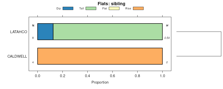
Naff-Palouse complex, 7 to 25 percent slopes332170624872782ph6sid05720131:24000
Palouse silt loam, 3 to 7 percent slopes35954524872802ph6vid05720131:24000
Palouse silt loam, 7 to 25 percent slopes36882724872812ph6wid05720131:24000
Palouse-Latahco complex, 0 to 3 percent slopes37230924872822ph6xid05720131:24000
Athena-Palouse complex, 7 to 25 percent slopes4181024872492ph5vid05720131:24000
Naff-Palouse complex, 8 to 20 percent slopes9017970797072ny6id61119941:24000
Naff-Palouse complex, 2 to 8 percent slopes896177797052ny4id61119941:24000
Palouse-Athena complex, 8 to 20 percent slopes1076034795712nstid61119941:24000
Naff, eroded-Palouse-Garfield complex, 8 to 20 percent slopes923132797092ny8id61119941:24000
Naff, eroded-Palouse complex, 8 to 20 percent slopes912851797082ny7id61119941:24000
Palouse-Athena complex, 2 to 8 percent slopes1062839795702nssid61119941:24000
Palouse-Naff complex, 3 to 8 percent slopes410188013898541hn80id62020131:24000
Naff-Palouse complex, 8 to 25 percent slopes417136113898591hn85id62020131:24000
Palouse silt loam, 8 to 25 percent slopes41138513898551hn81id62020131:24000
Palouse silt loam, 5 to 20 percent slopes46D72426398324kzor62519791:20000
Palouse silt loam, 0 to 5 percent slopes46B54686398224kyor62519791:20000
Palouse silt loam, 20 to 45 percent slopes46E5516398424l0or62519791:20000
Palouse silt loam, 12 to 20 percent slopes64D635564534254ror66719841:20000
Palouse silt loam, 1 to 7 percent slopes64B585364532254por66719841:20000
Palouse silt loam, 20 to 35 percent slopes64E544664535254sor66719841:20000
Palouse silt loam, 7 to 12 percent slopes64C442964533254qor66719841:20000
Palouse silt loam, 7 to 25 percent slopes652663066856329bqwa07519751:20000
Palouse-Thatuna silt loams, 7 to 25 percent slopes71623426857029bywa07519751:20000
Palouse silt loam, 25 to 40 percent slopes67111986856529bswa07519751:20000
Palouse silt loam, 3 to 7 percent slopes6495536856229bpwa07519751:20000
Palouse-Thatuna silt loams, 25 to 40 percent slopes7252796857129bzwa07519751:20000
Palouse silt loam, 7 to 25 percent slopes, eroded6639376856429brwa07519751:20000
Palouse silt loam, 40 to 55 percent slopes6910796856729bvwa07519751:20000
Palouse silt loam, 25 to 40 percent slopes, eroded6810126856629btwa07519751:20000
Palouse-Thatuna silt loams, 40 to 55 percent slopes739336857229c0wa07519751:20000
Palouse-Thatuna silt loams, 3 to 7 percent slopes706736856929bxwa07519751:20000
Naff-Palouse complex, 8 to 25 percent slopes4176927430901hn85wa07519751:20000
Palouse-Naff complex, 3 to 8 percent slopes4103927430921hn80wa07519751:20000
Palouse silt loam, 8 to 25 percent slopes4113827430941hn81wa07519751:20000
Palouse silt loam, 8 to 25 percent slopesPaD10488696852bhxwa61319671:20000
Palouse silt loam, 25 to 40 percent slopesPaE3696696872bhzwa61319671:20000
Palouse silt loam, 0 to 8 percent slopesPaB2871696842bhwwa61319671:20000
Palouse silt loam, 40 to 55 percent slopesPaF2530696892bj1wa61319671:20000
Palouse silt loam, moderately shallow, 3 to 15 percent slopesPeC2423696902bj2wa61319671:20000
Palouse silt loam, 25 to 40 percent slopes, severely erodedPaE32334696882bj0wa61319671:20000
Palouse silt loam, moderately shallow, 25 to 40 percent slopes, erodedPeE21017696922bj4wa61319671:20000
Palouse silt loam, moderately shallow, 15 to 25 percent slopes, erodedPeD2881696912bj3wa61319671:20000
Palouse silt loam, 8 to 25 percent slopes, severely erodedPaD3425696862bhywa61319671:20000
Palouse silt loam, moderately shallow, 7 to 25 percent slopesPlD1629698312bnmwa62319701:20000
Palouse silt loam, moderately shallow, 0 to 7 percent slopesPlB973698302bnlwa62319701:20000
Palouse silt loam, 7 to 25 percent slopesPaD510698292bnkwa62319701:20000
Palouse silt loam, moderately shallow, 25 to 40 percent slopesPlE409698322bnnwa62319701:20000
Palouse silt loam, 0 to 7 percent slopesPaB339698282bnjwa62319701:20000
Palouse silt loam, 8 to 30 percent slopes, erodedPaD211864713712d89wa67119611:31680
Palouse silt loam, moderately deep, 8 to 30 percent slopes, erodedPbD23172713762d8gwa67119611:31680
Palouse silt loam, moderately deep, 30 to 45 percent slopes, erodedPbE22852713782d8jwa67119611:31680
Palouse silt loam, 30 to 45 percent slopesPaE2561713722d8bwa67119611:31680
Palouse silt loam, 0 to 8 percent slopesPaB1869713692d87wa67119611:31680
Palouse silt loam, moderately deep, 30 to 45 percent slopesPbE1733713772d8hwa67119611:31680
Palouse silt loam, moderately deep, 45 to 60 percent slopesPbF1256713792d8kwa67119611:31680
Palouse silt loam, 8 to 30 percent slopesPaD1074713702d88wa67119611:31680
Palouse silt loam, moderately deep, 8 to 30 percent slopesPbD406713752d8fwa67119611:31680
Palouse silt loam, 45 to 60 percent slopesPaF335713732d8cwa67119611:31680
Palouse silt loam, moderately deep, 45 to 60 percent slopes, erodedPbF2261713802d8lwa67119611:31680
Palouse silt loam, moderately deep, 0 to 8 percent slopesPbB237713742d8dwa67119611:31680

Map of Series Extent

Approximate geographic distribution of the PALOUSE soil series. To learn more about how this distribution was mapped, or to compare this soil series extent to others, use the Series Extent Explorer (SEE) application. Source: generalization of SSURGO geometry .