| Palinor-Parisa association | 380 | 563 | 2634010 | 2wbhf | nv621 | 1971 | 1:24000 |
Palinor-Urmafot association | 283 | 757 | 2589863 | 2r374 | nv764 | 2021 | 1:24000 |
Palinor-Automal association | 429 | 91 | 2511435 | 2q8zp | nv764 | 2021 | 1:24000 |
Shabliss-Palinor association | 480 | 37939 | 478348 | j1rl | nv766 | 1994 | 1:24000 |
Palinor-Automal association | 421 | 24074 | 478328 | j1qy | nv766 | 1994 | 1:24000 |
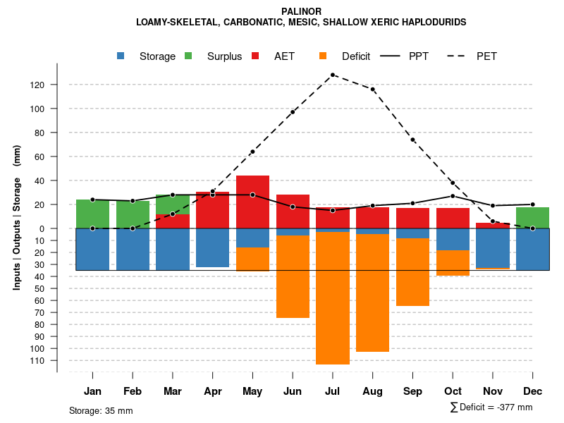
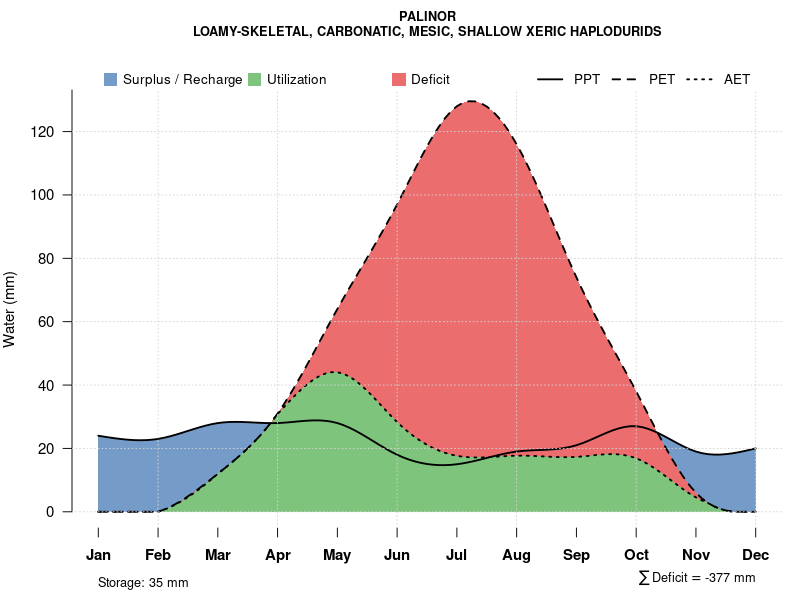
Palinor very gravelly loam, 2 to 15 percent slopes | 321 | 23956 | 2633962 | 2t6gw | nv766 | 1994 | 1:24000 |
Palinor-Urmafot association | 53 | 20536 | 478184 | 2t6h6 | nv766 | 1994 | 1:24000 |
Palinor-Automal-Palinor, eroded association | 429 | 16941 | 478336 | 2wbj0 | nv766 | 1994 | 1:24000 |
Palinor-Pharo-Hundraw association | 186 | 14398 | 478249 | j1nd | nv766 | 1994 | 1:24000 |
Palinor-Automal-Shabliss association | 854 | 12374 | 478500 | j1xh | nv766 | 1994 | 1:24000 |
Palinor-Parisa association | 856 | 11838 | 478502 | 2wbhf | nv766 | 1994 | 1:24000 |
Palinor-Shabliss-Linoyer association | 857 | 10554 | 478503 | j1xl | nv766 | 1994 | 1:24000 |
Palinor-Automal-Wintermute association | 426 | 10553 | 478333 | j1r3 | nv766 | 1994 | 1:24000 |
Palinor-Automal-Izar association | 188 | 7999 | 478251 | j1ng | nv766 | 1994 | 1:24000 |
Zafod-Pyrat-Palinor association | 230 | 7743 | 478265 | j1nx | nv766 | 1994 | 1:24000 |
Palinor-Zimbob-Tecomar association | 851 | 7558 | 478497 | j1xd | nv766 | 1994 | 1:24000 |
Izar-Palinor-Shabliss association | 251 | 5531 | 478274 | j1p6 | nv766 | 1994 | 1:24000 |
Palinor-Pyrat-Shabliss association | 852 | 5404 | 478498 | j1xf | nv766 | 1994 | 1:24000 |
Palinor-Hundraw-Okan association | 424 | 5247 | 478331 | j1r1 | nv766 | 1994 | 1:24000 |
Hundraw-Shabliss-Palinor association | 244 | 4649 | 478272 | j1p4 | nv766 | 1994 | 1:24000 |
Sodhouse-Palinor association | 497 | 4453 | 478360 | j1rz | nv766 | 1994 | 1:24000 |
Palinor-Wintermute-Okan association | 850 | 4332 | 478496 | j1xc | nv766 | 1994 | 1:24000 |
Palinor-Automal-Linoyer association | 858 | 3762 | 478504 | j1xm | nv766 | 1994 | 1:24000 |
Palinor-Zimbob-Okan association | 422 | 2972 | 478329 | j1qz | nv766 | 1994 | 1:24000 |
Palinor very gravelly loam, 2 to 15 percent slopes | 284 | 573 | 2634047 | 2rn2k | nv776 | 1983 | 1:63360 |
Palinor-Yody-Broland association | 6288 | 10697 | 2215783 | 2dcpw | nv778 | 2013 | 1:24000 |
Palinor-Urmafot-Palinor association | 6296 | 8090 | 2215785 | 2dcpy | nv778 | 2013 | 1:24000 |
Palinor-Palinor, moderately steep association | 4516 | 7856 | 2584232 | 2r1gb | nv778 | 2013 | 1:24000 |
Urmafot-Palinor association | 1282 | 7657 | 2215623 | 2dcjq | nv778 | 2013 | 1:24000 |
Palinor, moist-Urmafot association | 4608 | 6965 | 2632641 | 2rfww | nv778 | 2013 | 1:24000 |
Palinor very gravelly loam, 2 to 15 percent slopes | 6321 | 5244 | 2215787 | 2t6gw | nv778 | 2013 | 1:24000 |
Palinor-Urmafot-Urmafot, very shallow association | 6292 | 3005 | 2215784 | 2dcpx | nv778 | 2013 | 1:24000 |
Palinor-Urmafot association | 6283 | 1941 | 2215671 | 2dcl8 | nv778 | 2013 | 1:24000 |
Palinor-Parisa association | 3302 | 1857 | 2215690 | 2dclw | nv778 | 2013 | 1:24000 |
Palinor-Shabliss association | 6286 | 1069 | 2215781 | 2dcpt | nv778 | 2013 | 1:24000 |
Urmafot-Bobs-Palinor association | 6323 | 813 | 2215788 | 2dcq1 | nv778 | 2013 | 1:24000 |
Palinor-Wintermute association | 6287 | 597 | 2215782 | 2dcpv | nv778 | 2013 | 1:24000 |
Zimbob-Palinor association | 6119 | 365 | 2215770 | 2dcpg | nv778 | 2013 | 1:24000 |
Yody-Palinor-Shabliss association | 6573 | 203 | 2215803 | 2dcqj | nv778 | 2013 | 1:24000 |
Parisa-Palinor-Shabliss association | 6334 | 69 | 2215790 | 2dcq3 | nv778 | 2013 | 1:24000 |
Palinor-Izar-Biken association | 1287 | 39 | 2215624 | 2dcjr | nv778 | 2013 | 1:24000 |
Shabliss-Palinor association | 1060 | 10301 | 479928 | j3dk | nv779 | 2004 | 1:24000 |
Palinor-Tulase-Izar association | 3025 | 7253 | 479989 | j3gj | nv779 | 2004 | 1:24000 |
Automal-Izar-Palinor association | 3143 | 6572 | 480011 | j3h7 | nv779 | 2004 | 1:24000 |
Palinor-Urmafot association | 3024 | 6109 | 479988 | j3gh | nv779 | 2004 | 1:24000 |
Urmafot-Palinor-Shree association | 3410 | 4710 | 480068 | j3k2 | nv779 | 2004 | 1:24000 |
Palinor-Urmafot-Urmafot, very shallow association | 1051 | 1940 | 479927 | j3dj | nv779 | 2004 | 1:24000 |
Palinor-Automal-Palinor, eroded association | 4290 | 1930 | 1144496 | 17dy7 | nv779 | 2004 | 1:24000 |
Palinor-Shabliss association | 1052 | 1306 | 636698 | pcjn | nv779 | 2004 | 1:24000 |
Palinor-Urmafot-Palinor association | 6296 | 325 | 2817254 | 2tzhz | nv779 | 2004 | 1:24000 |
Palinor very gravelly loam, 2 to 15 percent slopes | 282 | 168403 | 480396 | 2t6gw | nv780 | 1990 | 1:24000 |
Palinor-Urmafot association | 53 | 83817 | 2633935 | 2t6h6 | nv780 | 1990 | 1:24000 |
Palinor-Shabliss association | 286 | 79203 | 480400 | j3ws | nv780 | 1990 | 1:24000 |
Palinor-Shabliss-Tulase association | 290 | 29348 | 480404 | j3wx | nv780 | 1990 | 1:24000 |
Urmafot-Bobs-Palinor association | 323 | 28780 | 480419 | j3xd | nv780 | 1990 | 1:24000 |
Palinor-Urmafot-Urmafot, very shallow association | 292 | 25148 | 480406 | j3wz | nv780 | 1990 | 1:24000 |
Palinor-Yody-Broland association | 288 | 21586 | 480402 | j3wv | nv780 | 1990 | 1:24000 |
Parisa-Palinor-Shabliss association | 334 | 17890 | 480430 | j3xr | nv780 | 1990 | 1:24000 |
Urmafot-Palinor association | 1282 | 14439 | 480222 | j3q1 | nv780 | 1990 | 1:24000 |
Palinor-Roden association | 295 | 14001 | 480409 | j3x2 | nv780 | 1990 | 1:24000 |
Palinor-Parisa association | 380 | 13307 | 480455 | 2wbhf | nv780 | 1990 | 1:24000 |
Shabliss-Pyrat-Palinor association | 458 | 10659 | 480490 | j3zp | nv780 | 1990 | 1:24000 |
Palinor-Molion-Broland association | 1280 | 9015 | 480220 | j3pz | nv780 | 1990 | 1:24000 |
Palinor-Wintermute association | 287 | 8897 | 480401 | j3wt | nv780 | 1990 | 1:24000 |
Sodhouse-Palinor association | 1821 | 8149 | 480325 | j3tc | nv780 | 1990 | 1:24000 |
Zimbob-Palinor association | 119 | 6094 | 480191 | j3p1 | nv780 | 1990 | 1:24000 |
Palinor-Urmafot-Roden association | 326 | 6072 | 480422 | j3xh | nv780 | 1990 | 1:24000 |
Parisa-Palinor-Tulase association | 338 | 6025 | 480434 | j3xw | nv780 | 1990 | 1:24000 |
Yody-Palinor-Shabliss association | 573 | 5244 | 480533 | j412 | nv780 | 1990 | 1:24000 |
Palinor-Izar-Biken association | 1287 | 4545 | 480226 | j3q5 | nv780 | 1990 | 1:24000 |
Palinor-Roden-Urmafot association | 322 | 3625 | 480418 | j3xc | nv780 | 1990 | 1:24000 |
Biken-Palinor-Barfan association | 1242 | 2115 | 480207 | j3pk | nv780 | 1990 | 1:24000 |
Pyrat-Palinor-Tulase association | 1491 | 1449 | 480277 | j3rt | nv780 | 1990 | 1:24000 |
Palinor-Parisa association | 3302 | 40729 | 480950 | j4gj | nv783 | 1991 | 1:24000 |
Handpah-Palinor-Parisa association | 3334 | 34251 | 480955 | j4gp | nv783 | 1991 | 1:24000 |
Palinor very gravelly loam, 2 to 15 percent slopes | 3300 | 32462 | 480948 | 2t6gw | nv783 | 1991 | 1:24000 |
Palinor-Nuc association | 3301 | 11600 | 480949 | j4gh | nv783 | 1991 | 1:24000 |
Palinor-Urmafot association | 4608 | 600 | 2817278 | 2tzjz | nv783 | 1991 | 1:24000 |
Palinor-Urmafot-Urmafot, very shallow association | 1211 | 30591 | 481145 | j4nt | nv784 | 2006 | 1:24000 |
Palinor very gravelly loam, 2 to 15 percent slopes | 1210 | 10968 | 481144 | 2t6gw | nv784 | 2006 | 1:24000 |
Urmafot-Bobs-Palinor association | 1200 | 4410 | 481143 | j4nr | nv784 | 2006 | 1:24000 |
Palinor-Yody-Broland association | 1212 | 158 | 481146 | j4nv | nv784 | 2006 | 1:24000 |


